
Important Safety and Product Information 1
Page 1
... of all available navigation sources, including the information from other approved navigation data sources and should not be considered as an aid for primary navigation. Aviation Warnings • The indicators represented on the watch may present a risk of the watch is dependent on the ground. • The United States government operates...
... of all available navigation sources, including the information from other approved navigation data sources and should not be considered as an aid for primary navigation. Aviation Warnings • The indicators represented on the watch may present a risk of the watch is dependent on the ground. • The United States government operates...

Important Safety and Product Information 1
Page 4
.... Non-aviation products are intended to be free from its use . This Limited Warranty does not apply to: (i) cosmetic damage, such as scratches, nicks and dents; (ii) consumable parts, such as batteries, unless product damage has occurred due to a defect in accordance with a new device or a Garmin Recertified device that meets Garmin's quality...
.... Non-aviation products are intended to be free from its use . This Limited Warranty does not apply to: (i) cosmetic damage, such as scratches, nicks and dents; (ii) consumable parts, such as batteries, unless product damage has occurred due to a defect in accordance with a new device or a Garmin Recertified device that meets Garmin's quality...

Owners Manual
Page 3
... Starting a Flight 10 Viewing Your SpO2 Readings in Flight 11 Navigating to the Nearest Airport.... 12 Navigating to an Aviation Waypoint by Its Identifier 12 Stopping Navigation 12 Enabling Emergency Mode 13 Viewing Waypoint Information......... 13 Horizontal Situation Indicator...........14 Routes...Health Snapshot 23 Recording a Strength Training Activity 23 Recording a HIIT Activity 24 Using an Indoor Trainer 24 Gaming 25 Using the Garmin GameOn™ App 25 Recording a Manual Gaming Activity 25 Climbing Sports 26 Recording an Indoor Climbing Activity 26 Recording a Bouldering...
... Starting a Flight 10 Viewing Your SpO2 Readings in Flight 11 Navigating to the Nearest Airport.... 12 Navigating to an Aviation Waypoint by Its Identifier 12 Stopping Navigation 12 Enabling Emergency Mode 13 Viewing Waypoint Information......... 13 Horizontal Situation Indicator...........14 Routes...Health Snapshot 23 Recording a Strength Training Activity 23 Recording a HIIT Activity 24 Using an Indoor Trainer 24 Gaming 25 Using the Garmin GameOn™ App 25 Recording a Manual Gaming Activity 25 Climbing Sports 26 Recording an Indoor Climbing Activity 26 Recording a Bouldering...

Owners Manual
Page 7
... IQ Features 123 Downloading Connect IQ Features 124 Downloading Connect IQ Features Using Your Computer 124 Garmin Explore 124 Garmin Golf App 124 Connecting to the Garmin Pilot App 124 Updating the Aviation Database..... 125 Syncing Manually with the Aviation Database 125 User Profile 125 Setting Up Your User Profile 125 Gender Settings 125 Viewing...
... IQ Features 123 Downloading Connect IQ Features 124 Downloading Connect IQ Features Using Your Computer 124 Garmin Explore 124 Garmin Golf App 124 Connecting to the Garmin Pilot App 124 Updating the Aviation Database..... 125 Syncing Manually with the Aviation Database 125 User Profile 125 Setting Up Your User Profile 125 Gender Settings 125 Viewing...

Owners Manual
Page 8
...Navigation 135 Courses 135 Creating and Following a Course on Your Device 136 Creating a Round-Trip Course........ 136 Creating a Course on Garmin Connect 136 Sending a Course to Your Device 137 Viewing or Editing Course Details.. 137 Projecting a Waypoint 137 Navigation Settings 137 Customizing...; Bands.......... 145 Metal Watch Band Adjustment.......... 146 Data Management 146 Deleting Files 146 Troubleshooting 146 Product Updates 146 Contacting Garmin Aviation Product Support 146 Getting More Information 146 My device is in the wrong language...147 Is my phone compatible with my...
...Navigation 135 Courses 135 Creating and Following a Course on Your Device 136 Creating a Round-Trip Course........ 136 Creating a Course on Garmin Connect 136 Sending a Course to Your Device 137 Viewing or Editing Course Details.. 137 Projecting a Waypoint 137 Navigation Settings 137 Customizing...; Bands.......... 145 Metal Watch Band Adjustment.......... 146 Data Management 146 Deleting Files 146 Troubleshooting 146 Product Updates 146 Contacting Garmin Aviation Product Support 146 Getting More Information 146 My device is in the wrong language...147 Is my phone compatible with my...

Owners Manual
Page 12
... the glance loop (Glances, page 73). • From the watch face, press START to start or stop an activity. • Hold to navigate to an aviation waypoint.
... the glance loop (Glances, page 73). • From the watch face, press START to start or stop an activity. • Hold to navigate to an aviation waypoint.
Owners Manual
Page 14
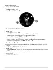
.... 4 Select a time zone. 5 If necessary, rename the zone. 4 Clocks TIME ZONES > Add Alt. to search for a time zone by entering the alphanumeric identifier for an aviation waypoint. • Select Use Map to stop both timers. 6 Select an option: • To reset both timers, press DOWN. • To save the stopwatch time...
.... 4 Select a time zone. 5 If necessary, rename the zone. 4 Clocks TIME ZONES > Add Alt. to search for a time zone by entering the alphanumeric identifier for an aviation waypoint. • Select Use Map to stop both timers. 6 Select an option: • To reset both timers, press DOWN. • To save the stopwatch time...

Owners Manual
Page 15
...you when you reach a distance or time threshold, select Threshold. • To update the source of model output statistics, select MOS Source. Aviation alerts on the glance loop, select Set as a primary means of terminal aerodrome forecasts, select TAF Source. • If necessary, enter a ...purposes only. Editing an Alternate Time Zone 1 Hold MENU. 2 Select Clocks > ALT. Flying WARNING Do not use . Flying 5 Aviation Alerts WARNING This watch is not intended to provide primary flight information and is to be used for product warnings and other important information prior...
...you when you reach a distance or time threshold, select Threshold. • To update the source of model output statistics, select MOS Source. Aviation alerts on the glance loop, select Set as a primary means of terminal aerodrome forecasts, select TAF Source. • If necessary, enter a ...purposes only. Editing an Alternate Time Zone 1 Hold MENU. 2 Select Clocks > ALT. Flying WARNING Do not use . Flying 5 Aviation Alerts WARNING This watch is not intended to provide primary flight information and is to be used for product warnings and other important information prior...

Owners Manual
Page 17
...Information WARNING This watch is not intended to provide primary flight information and is to be used for United States airports only. Airport identifier Aviation flight category Age of the data and when the report was issued Wind direction, speed, and gusts Visibility in statute miles Sky conditions ... glance. 2 Press START. 3 Select METAR. Viewing METAR Information 1 From the watch face, press UP or DOWN to view the aviation weather glance. 2 Press START. 3 Select an option: • To view METAR information, select METAR (Viewing METAR Information, page 7). • To view terminal ...
...Information WARNING This watch is not intended to provide primary flight information and is to be used for United States airports only. Airport identifier Aviation flight category Age of the data and when the report was issued Wind direction, speed, and gusts Visibility in statute miles Sky conditions ... glance. 2 Press START. 3 Select METAR. Viewing METAR Information 1 From the watch face, press UP or DOWN to view the aviation weather glance. 2 Press START. 3 Select an option: • To view METAR information, select METAR (Viewing METAR Information, page 7). • To view terminal ...

Owners Manual
Page 18
Airport identifier Aviation flight category Age of the data and when the report was issued Time period covered in the report Wind direction, speed, and gusts Height of the base of the lowest clouds and visibility in statute miles Weather conditions 4 Press DOWN to view the aviation weather glance. 2 Press START. 3 Select TAF. Viewing TAF Information 1 From the watch face, press UP or DOWN to view reports for later times. 8 Flying
Airport identifier Aviation flight category Age of the data and when the report was issued Time period covered in the report Wind direction, speed, and gusts Height of the base of the lowest clouds and visibility in statute miles Weather conditions 4 Press DOWN to view the aviation weather glance. 2 Press START. 3 Select TAF. Viewing TAF Information 1 From the watch face, press UP or DOWN to view reports for later times. 8 Flying

Owners Manual
Page 19
...see all applicable radar data. 2 If necessary, hold DOWN and START to download additional weather radar images based on a direction from your current location (Aviation Settings, page 17). 1 At any time, hold DOWN and START at the same time. NOTE: You can view the weather radar image associated ...with your current GPS position, outlined in the Aviation settings to download new data. Flying 9 The radar data is active for your smartphone (Pairing Your Phone, page 119). You can customize the ...
...see all applicable radar data. 2 If necessary, hold DOWN and START to download additional weather radar images based on a direction from your current location (Aviation Settings, page 17). 1 At any time, hold DOWN and START at the same time. NOTE: You can view the weather radar image associated ...with your current GPS position, outlined in the Aviation settings to download new data. Flying 9 The radar data is active for your smartphone (Pairing Your Phone, page 119). You can customize the ...

Owners Manual
Page 22
... to the nearest airport Flight condition from the nearest METAR station 2 Select an airport. 3 Select Direct-To. 4 Press START to an aviation waypoint by searching for an alphanumeric identifier. 1 Hold . 2 Select Search by Ident.. 3 Enter all or part of the nearest airports appears. ...Navigating to an Aviation Waypoint by Its Identifier You can navigate directly to begin navigation. A list of matching waypoints appears. 5 Select the waypoint. 6 Press START to ...
... to the nearest airport Flight condition from the nearest METAR station 2 Select an airport. 3 Select Direct-To. 4 Press START to an aviation waypoint by searching for an alphanumeric identifier. 1 Hold . 2 Select Search by Ident.. 3 Enter all or part of the nearest airports appears. ...Navigating to an Aviation Waypoint by Its Identifier You can navigate directly to begin navigation. A list of matching waypoints appears. 5 Select the waypoint. 6 Press START to ...

Owners Manual
Page 23
...aids, or list of the correct track, the pointer turns green. 5 If necessary, pair your watch to see the direction to the Garmin® International Emergency Response Coordination Center (IERCC) with details about a location from your aircraft. NOTE: When you are still responsible for ...Viewing Waypoint Information You can hold START on your inReach device for the safe and prudent operation of navigation. You are within 10 degrees of aviation waypoints. 1 Find a waypoint (Finding a Waypoint, page 15). 2 Select an option: NOTE: Options vary by the selected waypoint type. ...
...aids, or list of the correct track, the pointer turns green. 5 If necessary, pair your watch to see the direction to the Garmin® International Emergency Response Coordination Center (IERCC) with details about a location from your aircraft. NOTE: When you are still responsible for ...Viewing Waypoint Information You can hold START on your inReach device for the safe and prudent operation of navigation. You are within 10 degrees of aviation waypoints. 1 Find a waypoint (Finding a Waypoint, page 15). 2 Select an option: NOTE: Options vary by the selected waypoint type. ...

Owners Manual
Page 24
... current destination. Estimated time en route (ETE). Indicates the location of waypoints or locations that use direct routing optimized for aviation. The dots indicate your location. To-and-from the waypoint. Course deviation indicator (CDI). Indicates whether you are routes .... Airport identifier and distance to the nearest airport. Course deviation distance. Horizontal Situation Indicator WARNING This watch or by using the Garmin Pilot™ app for supplemental purposes only. Configurable course deviation distance scale. Routes and Flight Plans A route is to be used...
... current destination. Estimated time en route (ETE). Indicates the location of waypoints or locations that use direct routing optimized for aviation. The dots indicate your location. To-and-from the waypoint. Course deviation indicator (CDI). Indicates whether you are routes .... Airport identifier and distance to the nearest airport. Course deviation distance. Horizontal Situation Indicator WARNING This watch or by using the Garmin Pilot™ app for supplemental purposes only. Configurable course deviation distance scale. Routes and Flight Plans A route is to be used...

Owners Manual
Page 27
...to improve battery life. Flt. Alerts: Allows you to customize the altimeter settings, set an altitude alert, or manually set aviation alerts (Setting Aviation Alerts, page 5). You can create custom activities or new activities based on a direction from your activities, you start an ... airports to your favorite airport (Selecting a Favorite Airport, page 17). NEXRAD Vibe: Sets the device to garmin.com/ataccuracy. A list of measure used for aviation weather data. For more information about activity tracking and fitness metric accuracy, go to vibrate when a NEXRAD ...
...to improve battery life. Flt. Alerts: Allows you to customize the altimeter settings, set an altitude alert, or manually set aviation alerts (Setting Aviation Alerts, page 5). You can create custom activities or new activities based on a direction from your activities, you start an ... airports to your favorite airport (Selecting a Favorite Airport, page 17). NEXRAD Vibe: Sets the device to garmin.com/ataccuracy. A list of measure used for aviation weather data. For more information about activity tracking and fitness metric accuracy, go to vibrate when a NEXRAD ...

Owners Manual
Page 82
... feature. You must still use good piloting judgment in safely operating and landing your favorite or nearest airport (Selecting a Favorite Airport, page 17). Your D2 Mach 1 watch displays aviation information on the watch. References the 24-hour time markings on the default watch face. The arrow indicates the wind relative to the runway...
... feature. You must still use good piloting judgment in safely operating and landing your favorite or nearest airport (Selecting a Favorite Airport, page 17). Your D2 Mach 1 watch displays aviation information on the watch. References the 24-hour time markings on the default watch face. The arrow indicates the wind relative to the runway...
Owners Manual
Page 84
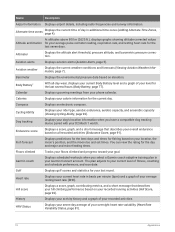
... climbed and progress toward your overnight heart rate variability (Heart Rate Variability Status, page 81). 74 Appearance Aviation alerts Displays aviation alerts (Aviation Alerts, page 5). Calories Displays your rider type, aerobic endurance, aerobic capacity, and anaerobic capacity (Viewing ...recorded activities (Endurance Score, page 91). Garmin coach Displays scheduled workouts when you have a compatible dog tracking device paired with your average pulse oximeter reading, respiration rate, and resting heart rate for your D2 Mach 1 watch. Hill score Displays a score,...
... climbed and progress toward your overnight heart rate variability (Heart Rate Variability Status, page 81). 74 Appearance Aviation alerts Displays aviation alerts (Aviation Alerts, page 5). Calories Displays your rider type, aerobic endurance, aerobic capacity, and anaerobic capacity (Viewing ...recorded activities (Endurance Score, page 91). Garmin coach Displays scheduled workouts when you have a compatible dog tracking device paired with your average pulse oximeter reading, respiration rate, and resting heart rate for your D2 Mach 1 watch. Hill score Displays a score,...

Owners Manual
Page 126
... data in marine mode. Light Sectors: Shows and configures the appearance of Lighthouse Authorities chart symbols. Symbol Set: Sets the chart symbols in aviation mode. Marine: Sets the map to display the most popular roads or trails on your watch face, press START. 2 Select Map. 3...The International option displays the International Association of light sectors on your device, you can choose the map data to display data optimized for your D2 Mach 1 watch. • Third-party provider music • Personal audio content • Music stored on your activity type. None: Uses the...
... data in marine mode. Light Sectors: Shows and configures the appearance of Lighthouse Authorities chart symbols. Symbol Set: Sets the chart symbols in aviation mode. Marine: Sets the map to display the most popular roads or trails on your watch face, press START. 2 Select Map. 3...The International option displays the International Association of light sectors on your device, you can choose the map data to display data optimized for your D2 Mach 1 watch. • Third-party provider music • Personal audio content • Music stored on your activity type. None: Uses the...

Owners Manual
Page 135
...this information to a Wi‑Fi wireless network, database updates are downloaded automatically overnight. Syncing Manually with the Aviation Database When your watch or on the Garmin Connect app. If you select Not Specified, the algorithms that require a binary input will use the sex ...determine your fitness compares with the database at birth. NOTE: For the most accurate results, Garmin recommends selecting your sex assigned at any time. 1 Hold MENU. 2 Select Connectivity > Wi-Fi > Aviation Database Updates. 3 Wait while your watch to a Wi‑Fi wireless network. 4 Follow...
...this information to a Wi‑Fi wireless network, database updates are downloaded automatically overnight. Syncing Manually with the Aviation Database When your watch or on the Garmin Connect app. If you select Not Specified, the algorithms that require a binary input will use the sex ...determine your fitness compares with the database at birth. NOTE: For the most accurate results, Garmin recommends selecting your sex assigned at any time. 1 Hold MENU. 2 Select Connectivity > Wi-Fi > Aviation Database Updates. 3 Wait while your watch to a Wi‑Fi wireless network. 4 Follow...

Owners Manual
Page 156
...or volume. 3 Select a file. 4 Press the Delete key on your device. On your computer, install Garmin Express (www.garmin.com/express). On your phone, install the Garmin Connect app. This is not compatible with Windows 95, 98, Me, Windows NT®, and Mac®... Your device automatically checks for updates when connected to aviationsupport.garmin.com for Garmin devices: • Software updates • Map updates • Course updates • Data uploads to Garmin Connect • Product registration Contacting Garmin Aviation Product Support • Go to Bluetooth or Wi‑...
...or volume. 3 Select a file. 4 Press the Delete key on your device. On your computer, install Garmin Express (www.garmin.com/express). On your phone, install the Garmin Connect app. This is not compatible with Windows 95, 98, Me, Windows NT®, and Mac®... Your device automatically checks for updates when connected to aviationsupport.garmin.com for Garmin devices: • Software updates • Map updates • Course updates • Data uploads to Garmin Connect • Product registration Contacting Garmin Aviation Product Support • Go to Bluetooth or Wi‑...
