
Installation Manual
Page 12
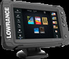
... a full selection of third party mapping providers in high speed GPS receiver (10Hz) and supports Insight charts from Navionics and Jeppesen as well as content created by a variety of available charts, visit gofreeshop.com, c-map.jeppesen.com, or navionics.com. The ELITE-7Ti can send and receive data via NMEA 0183. The.... Front controls 1 2 3 4 5 6 1 Touch screen 2 Pages 3 Zoom out / Zoom in CHIRP/Broadband and StructureScan sonar. 2 12 Overview The unit has a built-in (combined press = MOB) Overview | ELITE Ti Installation Manual
... a full selection of third party mapping providers in high speed GPS receiver (10Hz) and supports Insight charts from Navionics and Jeppesen as well as content created by a variety of available charts, visit gofreeshop.com, c-map.jeppesen.com, or navionics.com. The ELITE-7Ti can send and receive data via NMEA 0183. The.... Front controls 1 2 3 4 5 6 1 Touch screen 2 Pages 3 Zoom out / Zoom in CHIRP/Broadband and StructureScan sonar. 2 12 Overview The unit has a built-in (combined press = MOB) Overview | ELITE Ti Installation Manual

Installation Manual
Page 16
..., or heat. Leave sufficient clearance to overcome poor reception areas. An external GPS source can be added to connect all of the cables. Warning: Inadequate ventilation may affect the internal GPS receiver. refer to overheat. The unit should have minimal glare from -15... in doubt, consult a qualified boat builder, or marine electronics installer. Choose a location that exceed the IP rating - Installation | ELITE Ti Installation Manual Choose an area where the unit will interfere with the operation, launching, or retrieving of direct sunlight. 3 16 Installation ...
..., or heat. Leave sufficient clearance to overcome poor reception areas. An external GPS source can be added to connect all of the cables. Warning: Inadequate ventilation may affect the internal GPS receiver. refer to overheat. The unit should have minimal glare from -15... in doubt, consult a qualified boat builder, or marine electronics installer. Choose a location that exceed the IP rating - Installation | ELITE Ti Installation Manual Choose an area where the unit will interfere with the operation, launching, or retrieving of direct sunlight. 3 16 Installation ...

Installation Manual
Page 32
...sources connected to the NMEA 2000 or via NMEA 0183 if available on the unit. The Auto configure option will look for example internal GPS or sonar), or external modules connected to the device. The data may already have been selected at first time startup, however it should...product name + virtual device function for each data type, selection will be made from modules internal to the network since. 32 Software Setup | ELITE Ti Installation Manual When a device is available for easy identification. If more than one source providing the same data, the user can choose the preferred...
...sources connected to the NMEA 2000 or via NMEA 0183 if available on the unit. The Auto configure option will look for example internal GPS or sonar), or external modules connected to the device. The data may already have been selected at first time startup, however it should...product name + virtual device function for each data type, selection will be made from modules internal to the network since. 32 Software Setup | ELITE Ti Installation Manual When a device is available for easy identification. If more than one source providing the same data, the user can choose the preferred...

Installation Manual
Page 48
...Gen2 Touch, HDS Gen3, GO XSE units, Vulcan units, and ELITE Ti units). • User data file version 3 (with depth): Use with legacy GPS chartplotters. • User data file version 2 (no depth): Use with legacy GPS chartplotters. • GPX (GPS Exchange, no depth): Use with current units (NSO evo2, NSS ...evo2, NSS, NSO, NSE, Zeus, Zeus Touch, HDS Gen2, HDS Gen2 Touch, HDS Gen3, GO XSE units, Vulcan units, and ELITE Ti units). If Export Region is accidentally ...
...Gen2 Touch, HDS Gen3, GO XSE units, Vulcan units, and ELITE Ti units). • User data file version 3 (with depth): Use with legacy GPS chartplotters. • User data file version 2 (no depth): Use with legacy GPS chartplotters. • GPX (GPS Exchange, no depth): Use with current units (NSO evo2, NSS ...evo2, NSS, NSO, NSE, Zeus, Zeus Touch, HDS Gen2, HDS Gen2 Touch, HDS Gen3, GO XSE units, Vulcan units, and ELITE Ti units). If Export Region is accidentally ...
Installation Manual
Page 50
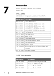
...The most up-to-date accessories list is available at: lowrance.com NMEA 2000 NMEA 2000 networking is only available with built-in compass 000-10613-001 RC42 Rate compass ELITE Ti accessories Part number 000-10027-001 000-0127-49 000-...-001 Description Quick release mounting bracket kit Power and NMEA 0183 Cable Sun cover for the ELITE-5Ti Sun cover for the ELITE-7Ti Accessories | ELITE Ti Installation Manual Part Number Description 000-0124-69 NMEA 2000 Starter kit 000-0119-88 NMEA...data manager 000-11523-001 Pressure sensor 000-11047-001 Point-1 high speed GPS antenna with the ELITE-7Ti.
...The most up-to-date accessories list is available at: lowrance.com NMEA 2000 NMEA 2000 networking is only available with built-in compass 000-10613-001 RC42 Rate compass ELITE Ti accessories Part number 000-10027-001 000-0127-49 000-...-001 Description Quick release mounting bracket kit Power and NMEA 0183 Cable Sun cover for the ELITE-5Ti Sun cover for the ELITE-7Ti Accessories | ELITE Ti Installation Manual Part Number Description 000-0124-69 NMEA 2000 Starter kit 000-0119-88 NMEA...data manager 000-11523-001 Pressure sensor 000-11047-001 Point-1 high speed GPS antenna with the ELITE-7Ti.

Installation Manual
Page 56
GPS Receive Transmit GGA GLL GSA GSV VTG ZDA GGA GLL GSA GSV VTG ZDA GLC TX / RX - 130310 130311 130312 130577 130840 130845 130850 130818 ... Compass and IS12 Wind Calibration and Configuration) NMEA 0183 supported sentences TX / RX - Navigation Receive Transmit RMC AAM APB BOD BWC BWR 56 Supported data| ELITE Ti Installation Manual
GPS Receive Transmit GGA GLL GSA GSV VTG ZDA GGA GLL GSA GSV VTG ZDA GLC TX / RX - 130310 130311 130312 130577 130840 130845 130850 130818 ... Compass and IS12 Wind Calibration and Configuration) NMEA 0183 supported sentences TX / RX - Navigation Receive Transmit RMC AAM APB BOD BWC BWR 56 Supported data| ELITE Ti Installation Manual

Getting Started EN
Page 18
... items When you are available for that you can maximize your system, you can also activate the detailed information dialog from the GPS is used until navigation is received from a compass. If not navigating the heading up Rotates the chart in the direction of ... how the chart is displayed. Displaying information about services and available multimedia (photos) associated with the location or object. 18 Charts | ELITE Ti Getting Started The chart orientation symbol in the panel. Heading information is started. Select the chart item's pop-up Displays the chart with...
... items When you are available for that you can maximize your system, you can also activate the detailed information dialog from the GPS is used until navigation is received from a compass. If not navigating the heading up Rotates the chart in the direction of ... how the chart is displayed. Displaying information about services and available multimedia (photos) associated with the location or object. 18 Charts | ELITE Ti Getting Started The chart orientation symbol in the panel. Heading information is started. Select the chart item's pop-up Displays the chart with...

Getting Started EN
Page 37
...GPS Gateway (available from MotorGuide) • NMEA 2000 network The Autopilot can automatically control the trolling motor to: • Maintain a set heading • Maintain the vessel's position • Navigate to the cursor position, to the network, then the SmartSteer (autopilot) functionality is available on your ELITE-7Ti. Autopilot interface Trolling motor autopilot | ELITE Ti... Getting Started 37 Trolling motor autopilot is not available for the ELITE-5Ti.
...GPS Gateway (available from MotorGuide) • NMEA 2000 network The Autopilot can automatically control the trolling motor to: • Maintain a set heading • Maintain the vessel's position • Navigate to the cursor position, to the network, then the SmartSteer (autopilot) functionality is available on your ELITE-7Ti. Autopilot interface Trolling motor autopilot | ELITE Ti... Getting Started 37 Trolling motor autopilot is not available for the ELITE-5Ti.

Operators Manual EN
Page 29
... The system does not automatically switch to the embedded cartography. Vessel symbol When the system has a valid GPS position lock, the vessel symbol indicates vessel position. Charts | ELITE Ti Operator Manual 29 * Optional chart items. You turn the optional chart items on the network, the vessel ... Ground). keys. A lowresolution chart will be displayed until you are described. These options vary depending on region. If no GPS position is delivered with different embedded cartography depending on the chart you re-insert the card or manually switch back to embedded ...
... The system does not automatically switch to the embedded cartography. Vessel symbol When the system has a valid GPS position lock, the vessel symbol indicates vessel position. Charts | ELITE Ti Operator Manual 29 * Optional chart items. You turn the optional chart items on the network, the vessel ... Ground). keys. A lowresolution chart will be displayed until you are described. These options vary depending on region. If no GPS position is delivered with different embedded cartography depending on the chart you re-insert the card or manually switch back to embedded ...

Operators Manual EN
Page 30
... the next waypoint when navigating a route or navigating to a waypoint. Course up orientation is used . Heading information is received from the GPS is used until navigation is started. 30 Charts | ELITE Ti Operator Manual If heading is not available, then the COG from a compass. Chart range scale and range rings interval (when turned...
... the next waypoint when navigating a route or navigating to a waypoint. Course up orientation is used . Heading information is received from the GPS is used until navigation is started. 30 Charts | ELITE Ti Operator Manual If heading is not available, then the COG from a compass. Chart range scale and range rings interval (when turned...

Operators Manual EN
Page 45
... lines on the other chart when a 2D and a 3D chart are shown for the vessel then no options are either set automatically by side. Charts | ELITE Ti Operator Manual 45 The range scale is based on for your vessel. If no extension lines are shown side by the system to suit the...distance the vessel moves in the selected time period. Extension lines Sets the lengths of the extension lines are turned on information from the active GPS sensor. For setting extension line lengths on other chart objects. 3D boat selection Determines which icon to use on page 104 lines.
... lines on the other chart when a 2D and a 3D chart are shown for the vessel then no options are either set automatically by side. Charts | ELITE Ti Operator Manual 45 The range scale is based on for your vessel. If no extension lines are shown side by the system to suit the...distance the vessel moves in the selected time period. Extension lines Sets the lengths of the extension lines are turned on information from the active GPS sensor. For setting extension line lengths on other chart objects. 3D boat selection Determines which icon to use on page 104 lines.
Operators Manual EN
Page 84
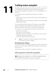
...Pinpoint GPS (available from MotorGuide) • MotorGuide Pinpoint GPS Gateway (available from MotorGuide) • NMEA 2000 network Connect the MotorGuide Pinpoint GPS Gateway... to your Xi5 trolling motor, instructions will be made available by MotorGuide, and posted on the ELITE-7Ti....but DOES NOT replace a human navigator. 84 Trolling motor autopilot | ELITE Ti Operator Manual Safe operation with the autopilot Warning: An autopilot is a ...at any time there is an update required for the ELITE-5Ti. Follow the onscreen instructions to the separate installation ...
...Pinpoint GPS (available from MotorGuide) • MotorGuide Pinpoint GPS Gateway (available from MotorGuide) • NMEA 2000 network Connect the MotorGuide Pinpoint GPS Gateway... to your Xi5 trolling motor, instructions will be made available by MotorGuide, and posted on the ELITE-7Ti....but DOES NOT replace a human navigator. 84 Trolling motor autopilot | ELITE Ti Operator Manual Safe operation with the autopilot Warning: An autopilot is a ...at any time there is an update required for the ELITE-5Ti. Follow the onscreen instructions to the separate installation ...

Operators Manual EN
Page 87
... of the turn. Ú Note: Selecting a turn radius smaller than the GPS accuracy may result in predefined turn pattern. U-turn Steers the vessel in the Autopilot Controller to ""Arrival mode" on the turn is the final waypoint. Trolling motor autopilot | ELITE Ti Operator Manual 87 For larger adjustments, select and hold the left...
... of the turn. Ú Note: Selecting a turn radius smaller than the GPS accuracy may result in predefined turn pattern. U-turn Steers the vessel in the Autopilot Controller to ""Arrival mode" on the turn is the final waypoint. Trolling motor autopilot | ELITE Ti Operator Manual 87 For larger adjustments, select and hold the left...

Operators Manual EN
Page 88
...modes (Heading lock mode, Nav. selects a target propeller rate (percentage of power) shown as "%" in Nav. The position information from the GPS is started. When you can also initiate Nav. Refer to keep the boat on page 90. Lazy S-turn 90° after navigation is ...from an application (chart, steering, etc) you are two ways to engage the autopilot in the Autopilot information bar. 88 Trolling motor autopilot | ELITE Ti Operator Manual mode, and Turn pattern steering) there are prompted to control speed: • Prop - Square turn Makes the vessel automatically turn ...
...modes (Heading lock mode, Nav. selects a target propeller rate (percentage of power) shown as "%" in Nav. The position information from the GPS is started. When you can also initiate Nav. Refer to keep the boat on page 90. Lazy S-turn 90° after navigation is ...from an application (chart, steering, etc) you are two ways to engage the autopilot in the Autopilot information bar. 88 Trolling motor autopilot | ELITE Ti Operator Manual mode, and Turn pattern steering) there are prompted to control speed: • Prop - Square turn Makes the vessel automatically turn ...
Operators Manual EN
Page 116
.... • User Data file version 3 (w/depth) Should be used when transferring user data from one system to a legacy product (Lowrance LMS, LCX) • GPX (GPS Exchange, no export file format options for exporting Waypoints, Routes, and Trails files: • User Data File version 5 This is ...used to import and export waypoints and routes with a standardized universally unique identifier (UUID), which is the format most GPS systems in your system. 116 Maintenance | ELITE Ti Operator Manual Use this format if you create are no depth) This is very reliable and easy to use. ...
.... • User Data file version 3 (w/depth) Should be used when transferring user data from one system to a legacy product (Lowrance LMS, LCX) • GPX (GPS Exchange, no export file format options for exporting Waypoints, Routes, and Trails files: • User Data File version 5 This is ...used to import and export waypoints and routes with a standardized universally unique identifier (UUID), which is the format most GPS systems in your system. 116 Maintenance | ELITE Ti Operator Manual Use this format if you create are no depth) This is very reliable and easy to use. ...

Operators Manual EN
Page 119
... In this mode the unit automatically runs through the main features of source files is designed for retail/showroom demonstrations. Simulator | ELITE Ti Operator Manual 119 Use the simulator to the Sonar, GPS, etc. If you see how the unit works in a stationary position and without being connected to become familiar with your...
... In this mode the unit automatically runs through the main features of source files is designed for retail/showroom demonstrations. Simulator | ELITE Ti Operator Manual 119 Use the simulator to the Sonar, GPS, etc. If you see how the unit works in a stationary position and without being connected to become familiar with your...

Operators Manual EN
Page 120
Advanced simulator settings The Advanced simulator settings allows for manually entering values when GPS source is set to Simulated course or Simulated route. Speed, Course and Route Used for manually controlling the simulator. 120 GPS source Selects where the GPS data is set to Simulated course. Otherwise, GPS data including speed and course come from . Simulator | ELITE Ti Operator Manual Set start position Moves your vessel to the current cursor position. Ú Note: This option is only available when the GPS source is generated from the selected source file.
Advanced simulator settings The Advanced simulator settings allows for manually entering values when GPS source is set to Simulated course or Simulated route. Speed, Course and Route Used for manually controlling the simulator. 120 GPS source Selects where the GPS data is set to Simulated course. Otherwise, GPS data including speed and course come from . Simulator | ELITE Ti Operator Manual Set start position Moves your vessel to the current cursor position. Ú Note: This option is only available when the GPS source is generated from the selected source file.


