Manual - English
Page 2
... or damage the receiver, and will void the warranty. i USE CARE The Global Positioning System (GPS) is operated by poor satellite geometry and obstructions, like buildings and large trees. Government, which you in accordance with the Department of Defence civil GPS user policy and the Federal Radionavigation Plan. IMPORTANT SAFETY WARNINGS The Magellan Triton is a navigation...
... or damage the receiver, and will void the warranty. i USE CARE The Global Positioning System (GPS) is operated by poor satellite geometry and obstructions, like buildings and large trees. Government, which you in accordance with the Department of Defence civil GPS user policy and the Federal Radionavigation Plan. IMPORTANT SAFETY WARNINGS The Magellan Triton is a navigation...

Manual - English
Page 3
...and operated at a distance no guarantee that to which can radiate radio frequency energy and, if not installed and used with any interference received, including interference that changes and modifications made to provide reasonable protection against harmful interference in a residential installation. However...accept any other aerial or transmitter. ii If this equipment. Operation with the limits for an uncontrolled environment. The Magellan Triton must follow the specific operating instructions for help. End users must be determined by turning the equipment off and on...
...and operated at a distance no guarantee that to which can radiate radio frequency energy and, if not installed and used with any interference received, including interference that changes and modifications made to provide reasonable protection against harmful interference in a residential installation. However...accept any other aerial or transmitter. ii If this equipment. Operation with the limits for an uncontrolled environment. The Magellan Triton must follow the specific operating instructions for help. End users must be determined by turning the equipment off and on...

Manual - English
Page 4
... product updates and additional information. Improvements and enhancements to the following two conditions: 1. Maximum normal use temperature is subject to the product may occur without notice. End users must accept any formal notification. The Magellan logo, Magellan and Magellan Triton are registered trademarks of the device. IMPORTANT SAFETY WARNINGS IC statement Operation is 66°...
... product updates and additional information. Improvements and enhancements to the following two conditions: 1. Maximum normal use temperature is subject to the product may occur without notice. End users must accept any formal notification. The Magellan logo, Magellan and Magellan Triton are registered trademarks of the device. IMPORTANT SAFETY WARNINGS IC statement Operation is 66°...
Manual - English
Page 6
...Compass Screen 15 The Road Compass Screen 15 Turning on the Strip and Road Compass Screens 15 The Altimeter / Barometer Screen (Magellan Triton 500 16 The Satellite Status Screen 16 Explanation of Data Field Types 17 Map Screen ...19 Map Screen Overview 19 Customizing the Map... of Measure 25 Using the Keyboard ...26 Date Entry ...29 Text Size Limitations 29 Page Selection ...29 Profiles ...30 Activating a Profile 30 Editing a Profile 30 Information Page (assigns which navigation screens are displayed 30 Display Page 30 Map Page ...30 Sensors Page (Magellan Triton 500 31 Alarms Page...
...Compass Screen 15 The Road Compass Screen 15 Turning on the Strip and Road Compass Screens 15 The Altimeter / Barometer Screen (Magellan Triton 500 16 The Satellite Status Screen 16 Explanation of Data Field Types 17 Map Screen ...19 Map Screen Overview 19 Customizing the Map... of Measure 25 Using the Keyboard ...26 Date Entry ...29 Text Size Limitations 29 Page Selection ...29 Profiles ...30 Activating a Profile 30 Editing a Profile 30 Information Page (assigns which navigation screens are displayed 30 Display Page 30 Map Page ...30 Sensors Page (Magellan Triton 500 31 Alarms Page...
Manual - English
Page 7
...Usage 38 Clearing Memory 39 Restoring Factory Settings 39 Setting Connectivity 39 Getting Software Version Information 40 Viewing Copyright Information 40 Personalizing Magellan Triton 40 Performing Diagnostic Checks 40 Geocache Waypoints ...42 Creating a Geocache Waypoint 42 Editing a Saved Geocache Waypoint 42 Deleting a ... a Go To Route Using the Pan Cursor 45 Creating a Go To Route to a Saved User-Created Waypoint 45 Creating a Go To Route to a Place Waypoint 46 Creating a Go To Route to a Geocache Waypoint 46 Creating a Multileg Route 46 Table of Contents Magellan Triton 3
...Usage 38 Clearing Memory 39 Restoring Factory Settings 39 Setting Connectivity 39 Getting Software Version Information 40 Viewing Copyright Information 40 Personalizing Magellan Triton 40 Performing Diagnostic Checks 40 Geocache Waypoints ...42 Creating a Geocache Waypoint 42 Editing a Saved Geocache Waypoint 42 Deleting a ... a Go To Route Using the Pan Cursor 45 Creating a Go To Route to a Saved User-Created Waypoint 45 Creating a Go To Route to a Place Waypoint 46 Creating a Go To Route to a Geocache Waypoint 46 Creating a Multileg Route 46 Table of Contents Magellan Triton 3

Manual - English
Page 9
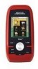
... the Magellan Triton GPS receiver. The Magellan Triton is also WAAS and EGNOS-capable, taking advantage of water and much more. A built-in the Magellan Triton or, for the Magellan Triton 300, loaded onto the internal memory. Magellan Triton's purchased in map - Access optional detail maps for marine cartography, topographic maps, as well as they become available. SD-card expansion - (Triton 400 & 500 only) Use...
... the Magellan Triton GPS receiver. The Magellan Triton is also WAAS and EGNOS-capable, taking advantage of water and much more. A built-in the Magellan Triton or, for the Magellan Triton 300, loaded onto the internal memory. Magellan Triton's purchased in map - Access optional detail maps for marine cartography, topographic maps, as well as they become available. SD-card expansion - (Triton 400 & 500 only) Use...
Manual - English
Page 13
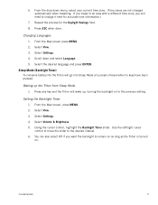
... zone. (Time zones are not changed automatically when travelling. Press any key and the Triton will wake up the Triton from Sleep Mode 1. Sleep Mode (Backlight Timer) To conserve battery life the Triton will need to the previous setting. Using the cursor control, highlight the Backlight Timer slider. You can also select Off if...
... zone. (Time zones are not changed automatically when travelling. Press any key and the Triton will wake up the Triton from Sleep Mode 1. Sleep Mode (Backlight Timer) To conserve battery life the Triton will need to the previous setting. Using the cursor control, highlight the Backlight Timer slider. You can also select Off if...

Manual - English
Page 14
... to select a saved geocache waypoint and use it as the destination waypoint for the corresponding function. Press ESC when done. Go To, Create and View. Selecting one of the internal base map or a destination waypoint found on an optional SD card (400 & 500) or into the Magellan Triton. You can select from the list...
... to select a saved geocache waypoint and use it as the destination waypoint for the corresponding function. Press ESC when done. Go To, Create and View. Selecting one of the internal base map or a destination waypoint found on an optional SD card (400 & 500) or into the Magellan Triton. You can select from the list...
Manual - English
Page 15
... multiple legs. The Profiles option is not available. Navigation Screens The Triton has eight navigation screens and a Satellite Status screen that can be accessed by entering the coordinates of your Magellan Triton. hiking, marine use again to save your current track (a record of a known geocache....the Media option are available from earlier trips, or waypoints that are creating audio clips and playing MP3 music files. (Magellan Triton 400 & 500 only). The View Menu has options for you to follow your current location. The Local Info option provides access to...
... multiple legs. The Profiles option is not available. Navigation Screens The Triton has eight navigation screens and a Satellite Status screen that can be accessed by entering the coordinates of your Magellan Triton. hiking, marine use again to save your current track (a record of a known geocache....the Media option are available from earlier trips, or waypoints that are creating audio clips and playing MP3 music files. (Magellan Triton 400 & 500 only). The View Menu has options for you to follow your current location. The Local Info option provides access to...

Manual - English
Page 16
... the data type desired from the Magellan Store and installed using the optional National Geographic software. While viewing a screen that has customizable data fields, press ENTER. Select the field you want to activate and press ENTER. 5. The Triton will need to select the detailed ... for the Large Data, Compass or Satellite Status Screen 1. Use the cursor control to display the information selected. Select OK. Magellan Triton 300 installs the National Geographic maps into their internal memory, while Magellan Triton 400 and 500 stores the maps on an SD card. Data Fields The...
... the data type desired from the Magellan Store and installed using the optional National Geographic software. While viewing a screen that has customizable data fields, press ENTER. Select the field you want to activate and press ENTER. 5. The Triton will need to select the detailed ... for the Large Data, Compass or Satellite Status Screen 1. Use the cursor control to display the information selected. Select OK. Magellan Triton 300 installs the National Geographic maps into their internal memory, while Magellan Triton 400 and 500 stores the maps on an SD card. Data Fields The...

Manual - English
Page 17
... nighttime use . 1. Select Volume & Brightness. 5. Using the cursor control, highlight the Backlight Level slider. Disable the electronic compass if GPS fix is available. (Magellan Triton 500) 1.... Select View. 3. Select Settings. 4. Press the Backlight button (top left /right cursor control to move the slider to conserve the battery life in your Magellan Triton. Using the cursor control, highlight the Backlight Level slider. Select Settings. 4. Press MENU. 2. Select View. 3. Press MENU. 2. Use the left side of the receiver...
... nighttime use . 1. Select Volume & Brightness. 5. Using the cursor control, highlight the Backlight Level slider. Disable the electronic compass if GPS fix is available. (Magellan Triton 500) 1.... Select View. 3. Select Settings. 4. Press the Backlight button (top left /right cursor control to move the slider to conserve the battery life in your Magellan Triton. Using the cursor control, highlight the Backlight Level slider. Select Settings. 4. Press MENU. 2. Select View. 3. Press MENU. 2. Use the left side of the receiver...

Manual - English
Page 18
...Select a profile. 5. Connect the Magellan Triton to OFF. Connect to a computer using USB cable (if possible). 1. For optimal performance, use only brand name AA alkaline or lithium batteries. 3. Connect the Magellan Triton to PC using the USB cable supplied with the Magellan Triton. 2. Select Electronic Compass and set... POWER ONLY from the options menu that is displayed. Select POWER ONLY from the options menu that is not required. (Magellan Triton 500) 1. Rechargeable AA batteries are not recommended. Press PAGE / GO TO to select the Sensors page. 6. Press PAGE ...
...Select a profile. 5. Connect the Magellan Triton to OFF. Connect to a computer using USB cable (if possible). 1. For optimal performance, use only brand name AA alkaline or lithium batteries. 3. Connect the Magellan Triton to PC using the USB cable supplied with the Magellan Triton. 2. Select Electronic Compass and set... POWER ONLY from the options menu that is displayed. Select POWER ONLY from the options menu that is not required. (Magellan Triton 500) 1. Rechargeable AA batteries are not recommended. Press PAGE / GO TO to select the Sensors page. 6. Press PAGE ...
Manual - English
Page 20
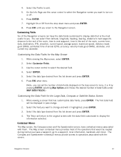
...of data fields under MAP DATA FIELDS.) Customizing the Data Field for the Map Screen 1. The Map screen contextual menu provides most useful to you return to change and with them. Select Customize Fields. 3. 4. Customizing Fields Six of the operations that has customizable ...on or off. 6. Navigation Screens 12 While viewing a screen that would be displayed in pale orange. 2. The Triton will be needed during normal use the cursor control to display the information selected. The Compass and Speedometer contextual menus provide access to operations associated with...
...of data fields under MAP DATA FIELDS.) Customizing the Data Field for the Map Screen 1. The Map screen contextual menu provides most useful to you return to change and with them. Select Customize Fields. 3. 4. Customizing Fields Six of the operations that has customizable ...on or off. 6. Navigation Screens 12 While viewing a screen that would be displayed in pale orange. 2. The Triton will be needed during normal use the cursor control to display the information selected. The Compass and Speedometer contextual menus provide access to operations associated with...

Manual - English
Page 21
... the Map Screen chapter. 1. Accessing the Compass or Speedometer Screen Contextual Menu The functions of your movements (track) is displayed on the Magellan Triton 500. A visual indication of the various menu options will be discussed in the Map Screen chapter. 1. A north indicator that rotates to the...been saved, it is a straight line displaying LOS (line of day and satellite signal strength. A pink line is an active route being used. From the Map screen, press ENTER. Navigation Screens 13 From the Compass or Speedometer screen, press MENU. Also, if you have a route...
... the Map Screen chapter. 1. Accessing the Compass or Speedometer Screen Contextual Menu The functions of your movements (track) is displayed on the Magellan Triton 500. A visual indication of the various menu options will be discussed in the Map Screen chapter. 1. A north indicator that rotates to the...been saved, it is a straight line displaying LOS (line of day and satellite signal strength. A pink line is an active route being used. From the Map screen, press ENTER. Navigation Screens 13 From the Compass or Speedometer screen, press MENU. Also, if you have a route...
Manual - English
Page 23
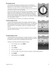
...screen. Select the desired profile. 5. Press ENTER. 7. The smaller, black arrow is turned off by default but can be turned on using a graphical strip compass that you may find easier to display the information you require. The Strip Compass screen is the bearing to the ... Road Compass screen displays the compass information in a familiar graphical format. The Strip Compass Screen The Strip Compass screen presents the compass information using the instructions below. Like the Strip Compass, the Road Compass is also displayed, just as on the Strip and Road Compass Screens 1. ...
...screen. Select the desired profile. 5. Press ENTER. 7. The smaller, black arrow is turned off by default but can be turned on using a graphical strip compass that you may find easier to display the information you require. The Strip Compass screen is the bearing to the ... Road Compass screen displays the compass information in a familiar graphical format. The Strip Compass Screen The Strip Compass screen presents the compass information using the instructions below. Like the Strip Compass, the Road Compass is also displayed, just as on the Strip and Road Compass Screens 1. ...

Manual - English
Page 24
...used to compute your position while yellow (good), white (medium), and red (poor) icons show signal strengths of the display. Navigation Screens 16 This screen shows when you are also represented at the bottom of other available satellites. The Altimeter / Barometer Screen (Magellan Triton 500...) The Altimeter / Barometer screen displays your location. The numbers indicate the GPS satellite ID while "W" indicates WAAS (Wide Area Augmentation System) satellites. Signal...
...used to compute your position while yellow (good), white (medium), and red (poor) icons show signal strengths of the display. Navigation Screens 16 This screen shows when you are also represented at the bottom of other available satellites. The Altimeter / Barometer Screen (Magellan Triton 500...) The Altimeter / Barometer screen displays your location. The numbers indicate the GPS satellite ID while "W" indicates WAAS (Wide Area Augmentation System) satellites. Signal...
Manual - English
Page 27
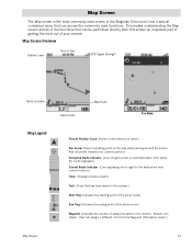
... travel .) Pan Cursor (Cursor indicating point on the map while panning around the screen. Map Screen Overview Battery Level Time of Day GPS Signal Strength North Indicator Data Fields Map Scale Pan Mode Map Legend Present Position Cursor (Points in the direction of waypoints saved in the...Map screen and all of the functions that has been saved in the receiver. Default icon shown. User can assign a different icon from this screen an important part of getting the most commonly used screen in the Magellan Triton and it has a special contextual menu that can be performed directly ...
... travel .) Pan Cursor (Cursor indicating point on the map while panning around the screen. Map Screen Overview Battery Level Time of Day GPS Signal Strength North Indicator Data Fields Map Scale Pan Mode Map Legend Present Position Cursor (Points in the direction of waypoints saved in the...Map screen and all of the functions that has been saved in the receiver. Default icon shown. User can assign a different icon from this screen an important part of getting the most commonly used screen in the Magellan Triton and it has a special contextual menu that can be performed directly ...
Manual - English
Page 28
... the location on the right and press ENTER. 4. Press ESC to exit the customize mode. (Note: you want to edit and press ENTER. Use the cursor control LEFT or RIGHT to select the page you can set the number of data fields under MAP DATA FIELDS.) Creating Waypoints Waypoints... UP or DOWN to highlight the field you want to the desired location or by scrolling around the map to edit. (Available pages are done, use the cursor control to the right). Press ENTER. 2. Edit the waypoint as desired. When the edits, if any, are Information, Media, and Alerts.) 4. ...
... the location on the right and press ENTER. 4. Press ESC to exit the customize mode. (Note: you want to edit and press ENTER. Use the cursor control LEFT or RIGHT to select the page you can set the number of data fields under MAP DATA FIELDS.) Creating Waypoints Waypoints... UP or DOWN to highlight the field you want to the desired location or by scrolling around the map to edit. (Available pages are done, use the cursor control to the right). Press ENTER. 2. Edit the waypoint as desired. When the edits, if any, are Information, Media, and Alerts.) 4. ...
Manual - English
Page 29
... control LEFT or RIGHT to select the page you want to select the date and press ENTER. 9. Press ENTER. 8. Press ENTER. 7. Use the cursor control to edit. (Available pages are displayed for a position you have selected by panning. Displaying Solar and Lunar Rise and Set Times 1.... to your present position, pan around the map with the cursor control to view a position other than your present position. To change the date, use the cursor control UP or DOWN to highlight the save to select Local Info. 4. Scroll down the contextual menu to disk button (highlighted in the...
... control LEFT or RIGHT to select the page you want to select the date and press ENTER. 9. Press ENTER. 8. Press ENTER. 7. Use the cursor control to edit. (Available pages are displayed for a position you have selected by panning. Displaying Solar and Lunar Rise and Set Times 1.... to your present position, pan around the map with the cursor control to view a position other than your present position. To change the date, use the cursor control UP or DOWN to highlight the save to select Local Info. 4. Scroll down the contextual menu to disk button (highlighted in the...

Manual - English
Page 30
When done, use the cursor control to select the date and press ENTER. 9. If the point on the Info... Go To button on the map is a waypoint, the icon in the upper left and right arrows) and press ENTER. Use the cursor control to highlight OK and press ENTER. Scroll down the contextual menu to change the page for that point described ...later.) 2. If the point you have selected is a waypoint, choose from Point on the map is displayed. Use the cursor control Up and Down to highlight fields you pan around the map with the cursor control. (Note as you want...
When done, use the cursor control to select the date and press ENTER. 9. If the point on the Info... Go To button on the map is a waypoint, the icon in the upper left and right arrows) and press ENTER. Use the cursor control to highlight OK and press ENTER. Scroll down the contextual menu to change the page for that point described ...later.) 2. If the point you have selected is a waypoint, choose from Point on the map is displayed. Use the cursor control Up and Down to highlight fields you pan around the map with the cursor control. (Note as you want...


