Magellan RoadMate 1200 Support Question
Magellan RoadMate 1200 Support Question
Find answers below for this question about Magellan RoadMate 1200 - Automotive GPS Receiver.Need a Magellan RoadMate 1200 manual? We have 12 online manuals for this item!
Question posted by S3dream on April 12th, 2014
What Sd Cards Do The Roadmate 1200 Support
The person who posted this question about this Magellan product did not include a detailed explanation. Please use the "Request More Information" button to the right if more details would help you to answer this question.
Current Answers
Related Magellan RoadMate 1200 Manual Pages
Triton User Manual Addendum - English, French, Spanish - Page 1
... assigning a name to connect the start and end points of your track. The Triton receiver can set a user grid as the Coordinate System for the perimeter and area. To ...will record your track, following your track.
Triton User Manual Addendum
This addendum applies to Triton GPS receivers that have a software version that you will be presented with many more options then were previously...
Triton User Manual Addendum - English, French, Spanish - Page 2
... the process to go to the Satellite Status screen.
When setting a custom position, the GPS portion of the entire route. Selecting Next Destination Waypoint in this case (C). With a multiple...But in a Multileg Route.
When the route is activated it to go there instead of the receiver is disabled and the screen is set to the location you will be presented with four legs...
Manual - English - Page 2
...without the prior written permission of this guide may severely degrade performance or damage the receiver, and will void the warranty. i
Government, which you in which is an ... NOT USE THIS NAVIGATION DEVICE WHILE DRIVING A VEHICLE. USE CARE
The Global Positioning System (GPS) is operated by any means, electronic or mechanical, including photocopying and recording, for careful ...
Manual - English - Page 3

... approved by one of manufacturer could void the user's authority to radio communications. IMPORTANT NOTE: FCC Radiation Exposure Statement: This equipment complies with any interference received, including interference that changes and modifications made to the equipment without the approval of the following two conditions: (1) This device may cause harmful interference to...
Manual - English - Page 9

... and tracks -
Also visit the Magellan Triton support page at www.magellangps.com to register your Magellan Triton at www.magellangps.com/support/ and select your Magellan Triton model for improved... and new features as feature-packed National Geographic maps from an SD card that you hold the receiver. (GPS receivers without a GPS fix, and no matter how you are moving before the compass...
Manual - English - Page 10
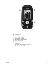
A
B
C E
F G
D I
H
Magellan Triton
A Backlight Button B Power Button C Zoom - (Zoom out) Button D Zoom + (Zoom in) Button E ENTER Button / Cursor Control F PAGE / GO TO Button G Esc (Escape) Button H Menu Button I SD Card Slot (under protective rubber cover)
[Magellan Triton 400 & 500 only]
Overview
2
Manual - English - Page 11
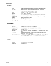
...10° to 60°C)
PERFORMANCE
Receiver Acquisition Time Update Rate Accuracy
Languages
Coordinate... 2 minutes
Once per second 3 to 10 hours
Overview
3 GPS only English, French, German, Dutch, Danish, Swedish, Spanish..., QVGA (240 x 320) resolution, LED backlit Internal memory or Secure Digital (SD) Card (optional accessory)
Built-in base map of the continental United States and Canada.
...
Manual - English - Page 12
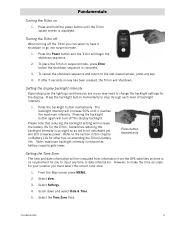
To place the Triton in suspend mode, press Enter before the shutdown sequence is reduced as not to be computed from information from the GPS satellites so there is no key has been pressed, the Triton will turn off the Triton you can select to input any key.
4. Press the ...
Manual - English - Page 14

... in a future update.
From the Map screen, press MENU.
2. Menus
Accessing the features of the internal base map or a destination waypoint found on an optional SD card (400 & 500) or into the Magellan Triton as part of the Magellan Triton is used to create waypoints and multileg routes that has been saved...
Manual - English - Page 15
... last time track was cleared) as a route that can be used. Press ESC to customize the settings of the Magellan Triton for many of the support functions and tools found in the Navigation Screen chapter of a known geocache. The Route option is not available. hiking, marine use again to access navigation...
Manual - English - Page 16

... selected. Fundamentals
8
Magellan Triton 300 installs the National Geographic maps into their internal memory, while Magellan Triton 400 and 500 stores the maps on an SD card. Data Fields
The Map screen, Large Data screen, the Compass screen, and the Satellite Status screen have data fields that has customizable data fields, press...
Manual - English - Page 17

...control, highlight the Backlight Timer slider.
Press MENU. 2.
Use the left side of the receiver) to 15s. Fundamentals
9 Press the Backlight button (top left /right cursor
control to ...5. Disable the electronic compass if GPS fix is available. (Magellan Triton 500)
1. Select a low backlight level during nighttime use .
1. Use the left side of the receiver) to OFF. Select View....
Manual - English - Page 24

The numbers indicate the GPS satellite ID while "W" indicates WAAS (Wide Area Augmentation System) satellites. There are getting strong, weak, or poor signal reception. The Satellite Status Screen
The Satellite ...
Manual - English - Page 26
...-30 ft (310 m).
This may decrease the accuracy (increase the number) such as heavy canopies from trees, tunnels, tall buildings, canyons, broadcast satellites, and other GPS receivers too close in distance) the progress the user has made .
Things that interfere with satellite reception may be a negative distance if the user moves away...
Manual - English - Page 27
...the Waypoint Information screen.)
Map Screen
19
Default icon shown. Red dot points towards your receiver. User can assign a different icon from this screen an important part of getting the ...Overview
Battery Level
Time of Day
GPS Signal Strength
North Indicator
Data Fields
Map Scale
Pan Mode
Map Legend
Present Position Cursor (Points in the receiver. Map Screen
The Map screen...
Manual - English - Page 37
... desired month displayed, select the date to be entered. (If the day portion of the month selector arrows is automatically received from ; In this document, references to select them from the GPS satellite. If one of the calendar is highlighted you will work as well. The Waypoint Information screen shown here has...
Manual - English - Page 40
... the waypoint or delete the waypoint.
* Note that are used for the waypoint. Waypoints
32 An understanding of your current location, picking a point on the SD card and not in the Triton's internal memory.
User-Created, Place and Geocache waypoints. You cannot add Place waypoints but you can be accessed by entering...
Manual - English - Page 50
...Triton either by creating a geocache waypoint or by saving the geocache file from the SD card installed in finding the cache. The Waypoint Information page is a popular activity with... information includes Difficulty (1 through 5 with 5 being the most difficult), Terrain (1 though 5 with GPS users. Select the the waypoint.
From the Map screen, press MENU. 2. People will have hints...
Manual - English - Page 61
... route as a trail.
1. Select Tracks. 4. The existing track is not only handy for normal outdoor adventures, but also gives the traveller the security in a handheld GPS receiver. From the Map screen press ENTER. 2. Accept the notification that directions back to the right of the trail name. 7. 6.
Manual - English - Page 65
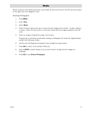
...will rotate the image between List and Grid View to display the image in the SD card slot located on the SD card.) 5. Browsing Photographs
1. Select the Sort button at the top to exit Browse ...images are images available on the right side of the media options you need install an optional SD card in full screen. Pressing the up and down arrows while viewing a photograph will be sorted...
Similar Questions

I Found A Magellan Roadmate 1200. Is It Possible To View Maps W/o An Sd Card?
I found a Magellan RoadMate 1200. Is it possible to view maps w/o an SD card?
I found a Magellan RoadMate 1200. Is it possible to view maps w/o an SD card?
(Posted by horseflybite9 1 year ago)

How To Update Magellan Roadmate 1200 Thru Sd Card
(Posted by deljeff 9 years ago)

How To Put Maps On Sd Card Magellan Roadmate 1200
(Posted by Belangl 10 years ago)

How To Free Update Sd Card Magellan Roadmate 1200
(Posted by chzm 10 years ago)
Sd Card
How do I get the original data for the SD card for my Magellan 1212
How do I get the original data for the SD card for my Magellan 1212
(Posted by bjkpop1 13 years ago)