
User Manual
Page 2
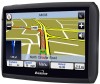
... ·GPS navigation device ·Car mounting kit ·In-car charger ·USB cable ·User guide ·Stylus Keep the packaging materials in a safe place in case you are required for products of no use the unit, you'll need to receive a satellite signal. Keep your sales (till) receipt, which is not advised. 2 Before you can check the number of satellite signals that you later need to fully charge the battery as...
... ·GPS navigation device ·Car mounting kit ·In-car charger ·USB cable ·User guide ·Stylus Keep the packaging materials in a safe place in case you are required for products of no use the unit, you'll need to receive a satellite signal. Keep your sales (till) receipt, which is not advised. 2 Before you can check the number of satellite signals that you later need to fully charge the battery as...

User Manual
Page 3
... injury or damage. Never modify the settings or program you Binatone Personal Navigation Device (PND). Any changes in GPS availability and accuracy, or in direct sun light. Do not pierce or break the battery casing. Using Your PND in the Car When using your PND in high temperatures (>60... you PND while driving. The GPS is essential that provides location and timing information around the globe. Only look at the PND map when it does not obscure your view or impede the operation of properly. Do not use it is operated and controlled under the sole responsibility of the...
... injury or damage. Never modify the settings or program you Binatone Personal Navigation Device (PND). Any changes in GPS availability and accuracy, or in direct sun light. Do not pierce or break the battery casing. Using Your PND in the Car When using your PND in high temperatures (>60... you PND while driving. The GPS is essential that provides location and timing information around the globe. Only look at the PND map when it does not obscure your view or impede the operation of properly. Do not use it is operated and controlled under the sole responsibility of the...

User Manual
Page 4
... Quick Start Guide 07 Position of the Controls 07 Charging the Battery 08 SD Memory Card 08 Car Adaptor 08 Turning the Sat Nav Unit On/Off 09 Turning the Sat Nav Unit Off (Sleep Mode 09 System Reset 09 Windscreen Holder Installation 10 Getting Started 11 Starting Up 11 Settings 12 Multi-Media 13 Picture Viewer 13 Document Viewer 14 Music 15 FM 16 Bluetooth Function 17 GPS Receiver 24 Additional maps...
... Quick Start Guide 07 Position of the Controls 07 Charging the Battery 08 SD Memory Card 08 Car Adaptor 08 Turning the Sat Nav Unit On/Off 09 Turning the Sat Nav Unit Off (Sleep Mode 09 System Reset 09 Windscreen Holder Installation 10 Getting Started 11 Starting Up 11 Settings 12 Multi-Media 13 Picture Viewer 13 Document Viewer 14 Music 15 FM 16 Bluetooth Function 17 GPS Receiver 24 Additional maps...

User Manual
Page 5
... 40 8.4.2 Edit an Entry 41 8.4.3 Delete an Entry 41 8.5 Day/Night Mode 42 8.6 Set Home Address 42 8.7 GPS Status 42 8.8 Miles/Kilometre 43 8.9 About 43 8.10 Time Zone 43 5 Navigational Map Screens 26 3.1 Free Navigation 27 3.2 Route Navigation 28 4. Map Options 36 7.1 North Up/Heading Up 36 7.2 3D/2D 37 7.3 Motorway Sign Post 37 7.4 Voice Guidance 37 7.5 Auto Zoom 38 7.6 Simulation Speed 38 8. CONTENTS NAVIGATION 1. Introduction 25 1.1 GPS connection 25 2.
... 40 8.4.2 Edit an Entry 41 8.4.3 Delete an Entry 41 8.5 Day/Night Mode 42 8.6 Set Home Address 42 8.7 GPS Status 42 8.8 Miles/Kilometre 43 8.9 About 43 8.10 Time Zone 43 5 Navigational Map Screens 26 3.1 Free Navigation 27 3.2 Route Navigation 28 4. Map Options 36 7.1 North Up/Heading Up 36 7.2 3D/2D 37 7.3 Motorway Sign Post 37 7.4 Voice Guidance 37 7.5 Auto Zoom 38 7.6 Simulation Speed 38 8. CONTENTS NAVIGATION 1. Introduction 25 1.1 GPS connection 25 2.

User Manual
Page 6
Route Plan 44 9.1 Navigating 44 9.2 Waypoints 45 9.3 Simulate 46 9.4 Route Options 46 10. Route Navigation Menu 46 10.1 Route Plan 47 10.2 Detour 47 10.3 Cancel Route 47 10.4 Go to 47 10.5 Route Information 48 10.6 Map Options 48 10.7 Settings 48 Frequently asked questions 49 The map contains an error / POI's are missing 49 I am experiencing problems getting a GPS fix 49 Where can I get technical support 49 Where can I get additional maps and guides 49 Technical Specifications 50 EC Declaration of Conformity 51 6 CONTENTS 8.11 Brightness 43 8.12 Calibration 44 9.
Route Plan 44 9.1 Navigating 44 9.2 Waypoints 45 9.3 Simulate 46 9.4 Route Options 46 10. Route Navigation Menu 46 10.1 Route Plan 47 10.2 Detour 47 10.3 Cancel Route 47 10.4 Go to 47 10.5 Route Information 48 10.6 Map Options 48 10.7 Settings 48 Frequently asked questions 49 The map contains an error / POI's are missing 49 I am experiencing problems getting a GPS fix 49 Where can I get technical support 49 Where can I get additional maps and guides 49 Technical Specifications 50 EC Declaration of Conformity 51 6 CONTENTS 8.11 Brightness 43 8.12 Calibration 44 9.
User Manual
Page 7
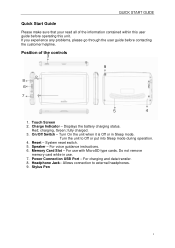
... or put into Sleep mode during operation. 4. On/Off Switch - Turn On the unit when it is Off or in use with MicroSD type cards. Position of the information contained within this user guide before contacting the customer helpline. Displays the battery charging status. charging, Green; For voice guidance instructions. 6. Power Connection USB Port - For use . 7. Stylus Pen 7 Touch Screen 2. QUICK START GUIDE Quick Start Guide Please make sure that your read all of the controls 3 9 2 8 6 7 1 5 4 1. System reset switch. 5.
... or put into Sleep mode during operation. 4. On/Off Switch - Turn On the unit when it is Off or in use with MicroSD type cards. Position of the information contained within this user guide before contacting the customer helpline. Displays the battery charging status. charging, Green; For voice guidance instructions. 6. Power Connection USB Port - For use . 7. Stylus Pen 7 Touch Screen 2. QUICK START GUIDE Quick Start Guide Please make sure that your read all of the controls 3 9 2 8 6 7 1 5 4 1. System reset switch. 5.
User Manual
Page 12
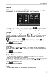
... by receiving 3 GPS signals. Press to confirm and exit Backlight Press 'Backlight' to change the date & time, select the item to be done via the navigation software later. Any changes in settings will mute/un-mute the speaker. Pressing the speaker button will not be done via the navigation software later. Volume Press 'volume' you exit by clicking " " or " ". Power The power page contains the information on the SETTINGS icon the following screen...
... by receiving 3 GPS signals. Press to confirm and exit Backlight Press 'Backlight' to change the date & time, select the item to be done via the navigation software later. Any changes in settings will mute/un-mute the speaker. Pressing the speaker button will not be done via the navigation software later. Volume Press 'volume' you exit by clicking " " or " ". Power The power page contains the information on the SETTINGS icon the following screen...
User Manual
Page 13
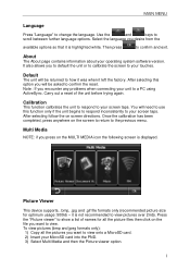
... the reset. Picture Viewer This device supports, .bmp, .jpg and .gif file formats only (recommended picture size for all the pictures you to default the unit or to calibrate the screen to your touches. Once the calibration has been completed, press anywhere on screen directions. Note : If you will be asked to a PC using ActiveSync. You will need to use this...
... the reset. Picture Viewer This device supports, .bmp, .jpg and .gif file formats only (recommended picture size for all the pictures you to default the unit or to calibrate the screen to your touches. Once the calibration has been completed, press anywhere on screen directions. Note : If you will be asked to a PC using ActiveSync. You will need to use this...

User Manual
Page 18
... the factory PIN: This is required when pairing the device with your mobile phone. Information Select the info icon in the Bluetooth menu to turn on the screen. The default setting is the software version number 18 When switched off all of the device, which is the PIN code of the other Bluetooth feature icons will allow you to the PIN code, which will be displayed on /off the Bluetooth function...
... the factory PIN: This is required when pairing the device with your mobile phone. Information Select the info icon in the Bluetooth menu to turn on the screen. The default setting is the software version number 18 When switched off all of the device, which is the PIN code of the other Bluetooth feature icons will allow you to the PIN code, which will be displayed on /off the Bluetooth function...

User Manual
Page 22
... numbers you will need to the instructions in transferring your mobile phone. To refresh the list simple tap on the unit. If you be moved a page at a time. You will you have made phonebook changes while being connected to refresh the phonebook list on the appropriate list icon again. Tap to make a call to the PND (which was last used...
... numbers you will need to the instructions in transferring your mobile phone. To refresh the list simple tap on the unit. If you be moved a page at a time. You will you have made phonebook changes while being connected to refresh the phonebook list on the appropriate list icon again. Tap to make a call to the PND (which was last used...

User Manual
Page 25
... current position in degrees longitude and latitude, your current speed and the status of this type. This is quite normal of products of your position, i.e. The compass circle shows the satellites that the unit is receiving also the strength of these satellites NOTE: At least four GPS signals are required for more information. 25 MAIN MENU GPS Receiver NOTE: This page is limited and GPS navigation Mode...
... current position in degrees longitude and latitude, your current speed and the status of this type. This is quite normal of products of your position, i.e. The compass circle shows the satellites that the unit is receiving also the strength of these satellites NOTE: At least four GPS signals are required for more information. 25 MAIN MENU GPS Receiver NOTE: This page is limited and GPS navigation Mode...

User Manual
Page 26
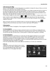
... first satellite connection. The device receives signals from the last location where you used the unit for navigation. In the car this application to plan your trip to suit your personal preferences and interests and to save interesting destinations before you set up your destination, whether you are far away from a number of GPS satellites in order to determine your current position. • Place your navigation device in a location with...
... first satellite connection. The device receives signals from the last location where you used the unit for navigation. In the car this application to plan your trip to suit your personal preferences and interests and to save interesting destinations before you set up your destination, whether you are far away from a number of GPS satellites in order to determine your current position. • Place your navigation device in a location with...
User Manual
Page 30
.... Free navigation and Route Navigation. 5.1 Free navigation In free navigation the unit does not have a valid GPS signal, this can also change the zoom level of the map to enter your current or last known GPS position. 5 Navigation There are currently not shown. If the icon is greyed out then there is no valid signal, if the icon is white with spoken directions to look at the GPS reception screen...
.... Free navigation and Route Navigation. 5.1 Free navigation In free navigation the unit does not have a valid GPS signal, this can also change the zoom level of the map to enter your current or last known GPS position. 5 Navigation There are currently not shown. If the icon is greyed out then there is no valid signal, if the icon is white with spoken directions to look at the GPS reception screen...

User Manual
Page 36
... GPS position or the last position you to enter the longitude and latitude co-ordinates of the map will change to the co-ordinates entry screen. Tap Coordinates the screen will then change to show the map. You can use the keyboard to enter the co-ordinates you wish to navigate to show the Route Plan screen (see page 34). The screen will change to show the Route Plan screen (see page 34). 6.6 Entering a set...
... GPS position or the last position you to enter the longitude and latitude co-ordinates of the map will change to the co-ordinates entry screen. Tap Coordinates the screen will then change to show the map. You can use the keyboard to enter the co-ordinates you wish to navigate to show the Route Plan screen (see page 34). The screen will change to show the Route Plan screen (see page 34). 6.6 Entering a set...
User Manual
Page 37
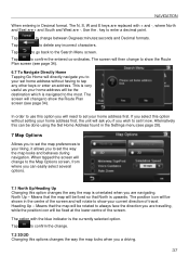
... West are travelling, while the position icon will need to set the map preferences to confirm the change between Degrees:minutes:seconds and Decimal formats. Tap to your home address first. Means that the map will be fixed so that the map will be rotated to show the Route Plan screen (see page 28). 7 Map Options Allows you are navigating. Heading Up - Alternatively this...
... West are travelling, while the position icon will need to set the map preferences to confirm the change between Degrees:minutes:seconds and Decimal formats. Tap to your home address first. Means that the map will be fixed so that the map will be rotated to show the Route Plan screen (see page 28). 7 Map Options Allows you are navigating. Heading Up - Alternatively this...
User Manual
Page 40
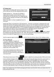
... approaching speed camera visually and shows you activate or deactivate the road speed limit warning. When active this information to open the safety alert options screen. It is activated. This lets you activate or deactivate the speed camera warning, when activated the unit will then change the speeding tolerance using the and keys to select the tolerance you have to the camera. NAVIGATION 8.2 Safety Alert Tap to draw a track of the route...
... approaching speed camera visually and shows you activate or deactivate the road speed limit warning. When active this information to open the safety alert options screen. It is activated. This lets you activate or deactivate the speed camera warning, when activated the unit will then change the speeding tolerance using the and keys to select the tolerance you have to the camera. NAVIGATION 8.2 Safety Alert Tap to draw a track of the route...

User Manual
Page 43
... and return to the settings screen. when selected allows you to change to the GPS status screen, Note; Use the and buttons to select the start time of between 1:00 till 12:00 AM and an end time of satellites which you information about your current GPS position. this information is the number of between these satellites in Longitude and latitude. NAVIGATION 8.5 Day/Night Mode Allows you to either...
... and return to the settings screen. when selected allows you to change to the GPS status screen, Note; Use the and buttons to select the start time of between 1:00 till 12:00 AM and an end time of satellites which you information about your current GPS position. this information is the number of between these satellites in Longitude and latitude. NAVIGATION 8.5 Day/Night Mode Allows you to either...

User Manual
Page 45
... Tap to return to the settings screen without saving. The unit will change to the Route Plan screen. follow the onscreen instructions in order to complete the calibration process. 9 Route Plan Once you have entered your screen taps. NAVIGATION Once set tap to confirm the selection and return to the Route Plan screen; The screen will be shown a warning screen, tap to confirm you will change to the route navigation screen and you can tap...
... Tap to return to the settings screen without saving. The unit will change to the Route Plan screen. follow the onscreen instructions in order to complete the calibration process. 9 Route Plan Once you have entered your screen taps. NAVIGATION Once set tap to confirm the selection and return to the Route Plan screen; The screen will be shown a warning screen, tap to confirm you will change to the route navigation screen and you can tap...

User Manual
Page 49
... viewed separately and is a detailed turn by the unit and the estimated time it will take to scroll through the list of the route, which includes - NAVIGATION 10.5 Route Information Tapping this option will detail the route in text format and contains useful information about the route you are currently viewing the first route. the next street name, distance between these two locations as planned by turn type. Use...
... viewed separately and is a detailed turn by the unit and the estimated time it will take to scroll through the list of the route, which includes - NAVIGATION 10.5 Route Information Tapping this option will detail the route in text format and contains useful information about the route you are currently viewing the first route. the next street name, distance between these two locations as planned by turn type. Use...

User Manual
Page 50
... sky. Please refer to inform our map data provider. If you cannot find an address. Please consult the hardware manual of your device to get further information on the map but you detect an error in London). Please contact our helpline or your entry. TECHNICAL SPECIFICATIONS Frequently asked questions I get software updates? Please make sure you have problems getting a GPS fix. If you are being received by going...
... sky. Please refer to inform our map data provider. If you cannot find an address. Please consult the hardware manual of your device to get further information on the map but you detect an error in London). Please contact our helpline or your entry. TECHNICAL SPECIFICATIONS Frequently asked questions I get software updates? Please make sure you have problems getting a GPS fix. If you are being received by going...


