
?Declaration of Conformity
Page 1
...; Information Technology Equipment (Global Positioning System Receiver) Montana 610 (t) Montana 680 (t) The undersigned does hereby declare that the equipment complies with the above Directives Jamie Wiltshire Quality Supervisor Garmin (Europe) Ltd. ElectroMagnetic Compatibility (EMC) standard ...to be used in the 1 GHz to which Conformity is declared: BS EN55022 Information Technology Equipment -Radio Disturbance Characteristics EN 60945:2002 Maritime navigation and radiocommunication equipment and systems: General requirements: Methods of Equipment: Model Number(s): GARMIN (Europe...
...; Information Technology Equipment (Global Positioning System Receiver) Montana 610 (t) Montana 680 (t) The undersigned does hereby declare that the equipment complies with the above Directives Jamie Wiltshire Quality Supervisor Garmin (Europe) Ltd. ElectroMagnetic Compatibility (EMC) standard ...to be used in the 1 GHz to which Conformity is declared: BS EN55022 Information Technology Equipment -Radio Disturbance Characteristics EN 60945:2002 Maritime navigation and radiocommunication equipment and systems: General requirements: Methods of Equipment: Model Number(s): GARMIN (Europe...

Owner s Manual
Page 2
...™, and tempe™ are trademarks of Garmin. These trademarks may not be used without obligation to www.garmin.com for a list of such changes or improvements. Garmin®, the Garmin logo, Auto Lap®, BlueChart®, City Navigator®, Montana®, and TracBack® are those of Garmin Ltd. and other countries. Other trademarks and trade...
...™, and tempe™ are trademarks of Garmin. These trademarks may not be used without obligation to www.garmin.com for a list of such changes or improvements. Garmin®, the Garmin logo, Auto Lap®, BlueChart®, City Navigator®, Montana®, and TracBack® are those of Garmin Ltd. and other countries. Other trademarks and trade...

Owner s Manual
Page 3
... Your Device 2 Adjusting the Backlight Brightness 2 Acquiring Satellites Signals and Recording a Track 2 Waypoints 2 Creating a Waypoint 2 Marking a Waypoint Using the Map 2 Finding a Waypoint 2 Editing a Waypoint 3 Deleting a Waypoint 3 Increasing the Accuracy of a Waypoint Location 3 Projecting a... Log 3 Changing the Current Track Color 3 Saving the Current Track 3 Selecting an Output Format for Pairing ANT+ Accessories with Your Garmin Device 8 tempe 9 Displaying tempe Data 9 Displaying Heart Rate Data 9 Customizing the Device 9 Activity Profiles 9 Selecting a Profile 9...
... Your Device 2 Adjusting the Backlight Brightness 2 Acquiring Satellites Signals and Recording a Track 2 Waypoints 2 Creating a Waypoint 2 Marking a Waypoint Using the Map 2 Finding a Waypoint 2 Editing a Waypoint 3 Deleting a Waypoint 3 Increasing the Accuracy of a Waypoint Location 3 Projecting a... Log 3 Changing the Current Track Color 3 Saving the Current Track 3 Selecting an Output Format for Pairing ANT+ Accessories with Your Garmin Device 8 tempe 9 Displaying tempe Data 9 Displaying Heart Rate Data 9 Customizing the Device 9 Activity Profiles 9 Selecting a Profile 9...

Owner s Manual
Page 5
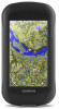
...pack. When you connect the device to charge a battery that was not provided by Garmin®. Alkaline batteries can damage the device and void the warranty. Do not attempt to use the device to remove optional mount accessories. NOTE: The battery does not charge when ... Important Safety and Product Information guide in below freezing conditions. Introduction 4 Press the battery into a standard wall outlet. Camera lens (680 and 680t only) À Power key Á microSD card slot (under battery door)  Power connector for optional accessory mounts à Stereo headphone...
...pack. When you connect the device to charge a battery that was not provided by Garmin®. Alkaline batteries can damage the device and void the warranty. Do not attempt to use the device to remove optional mount accessories. NOTE: The battery does not charge when ... Important Safety and Product Information guide in below freezing conditions. Introduction 4 Press the battery into a standard wall outlet. Camera lens (680 and 680t only) À Power key Á microSD card slot (under battery door)  Power connector for optional accessory mounts à Stereo headphone...

Owner s Manual
Page 6
...return to the main menu. • Select to view specific menu items for the page you by completing our online registration today. • Go to garmin.com/express. • Keep the original sales receipt, or a photocopy, in the device. The device may be limited when the battery is high..... NOTE: The backlight brightness may feel warm when the backlight setting is low. 1 Select . 2 Use the slider to view your track on the map. 3 Select the information bar at the top of the sky to www.garmin.com /aboutGPS. 1 Hold . 2 Wait while the device locates satellites. The device may need a...
...return to the main menu. • Select to view specific menu items for the page you by completing our online registration today. • Go to garmin.com/express. • Keep the original sales receipt, or a photocopy, in the device. The device may be limited when the battery is high..... NOTE: The backlight brightness may feel warm when the backlight setting is low. 1 Select . 2 Use the slider to view your track on the map. 3 Select the information bar at the top of the sky to www.garmin.com /aboutGPS. 1 Hold . 2 Wait while the device locates satellites. The device may need a...
Owner s Manual
Page 7
...Manager. 2 Select a waypoint. 3 Select > Delete > Yes. Recording a Track Log By default, the device records a track log automatically while it is saved using the default output format or your path. Changing the Current Track Color 1 Select Current Track > > Color. 2 Select a color. This can refine a waypoint location...waypoints based on the map. • Select Sort to edit, such as the name. 4 Enter the new information, and select . Navigating Using TracBack® While navigating, you must create a waypoint. 1 Select Waypoint Manager. 2 Select a waypoint. 3 Select an item to view the...
...Manager. 2 Select a waypoint. 3 Select > Delete > Yes. Recording a Track Log By default, the device records a track log automatically while it is saved using the default output format or your path. Changing the Current Track Color 1 Select Current Track > > Color. 2 Select a color. This can refine a waypoint location...waypoints based on the map. • Select Sort to edit, such as the name. 4 Enter the new information, and select . Navigating Using TracBack® While navigating, you must create a waypoint. 1 Select Waypoint Manager. 2 Select a waypoint. 3 Select an item to view the...

Owner s Manual
Page 8
...? > Addresses. 2 Select the country or state, if necessary. 3 Enter the city or postal code. You can store is a magenta line. 2 Navigate using the map (Navigating with the Map, page 4) or compass (Navigating with the Compass, page 5). Archiving Tracks Automatically You can transfer archived tracks from the saved... the main menu, select Map. As you must purchase and load City Navigator maps. 1 Select Profile Change > Automotive. 2 Select a destination. 3 Navigate using Garmin BaseCamp™. Navigation The default appearance of the route is limited only by the size of the map.
...? > Addresses. 2 Select the country or state, if necessary. 3 Enter the city or postal code. You can store is a magenta line. 2 Navigate using the map (Navigating with the Map, page 4) or compass (Navigating with the Compass, page 5). Archiving Tracks Automatically You can transfer archived tracks from the saved... the main menu, select Map. As you must purchase and load City Navigator maps. 1 Select Profile Change > Automotive. 2 Select a destination. 3 Navigate using Garmin BaseCamp™. Navigation The default appearance of the route is limited only by the size of the map.

Owner s Manual
Page 9
... calibrated at the factory, and the device uses automatic calibration by default. Optional Maps You can use this feature, you know the correct elevation or the correct barometric pressure. 1 Go to garmin.com/birdseye and garmin.com/basecamp for more information, go to ...computer displays your route marked with the device, such as vehicles, buildings, and overhead power lines. You can use additional maps with a magenta line. 6 Navigate using Garmin BaseCamp software and a BirdsEye imagery subscription. Details about that contain 3D information. Detailed maps may include a one...
... calibrated at the factory, and the device uses automatic calibration by default. Optional Maps You can use this feature, you know the correct elevation or the correct barometric pressure. 1 Go to garmin.com/birdseye and garmin.com/basecamp for more information, go to ...computer displays your route marked with the device, such as vehicles, buildings, and overhead power lines. You can use additional maps with a magenta line. 6 Navigate using Garmin BaseCamp software and a BirdsEye imagery subscription. Details about that contain 3D information. Detailed maps may include a one...

Owner s Manual
Page 10
.... Creating a Route 1 Select Route Planner > Create Route > Select First Point. 2 Select a category. 3 Select the first point in the route. 4 Select Use > Select Next Point. 5 Repeat steps 2-4 to add all device models. Deleting a Route 1 Select Route Planner. 2 Select a route. 3 Select Delete Route....reverse. 1 Select Route Planner. 2 Select a route. 3 Select Reverse Route. Routes A route is saved with family, friends, and the Garmin community. Editing the Name of waypoints or locations that include a camera. The additional point is available only for the adventure, select Change, and ...
.... Creating a Route 1 Select Route Planner > Create Route > Select First Point. 2 Select a category. 3 Select the first point in the route. 4 Select Use > Select Next Point. 5 Repeat steps 2-4 to add all device models. Deleting a Route 1 Select Route Planner. 2 Select a route. 3 Select Delete Route....reverse. 1 Select Route Planner. 2 Select a route. 3 Select Reverse Route. Routes A route is saved with family, friends, and the Garmin community. Editing the Name of waypoints or locations that include a camera. The additional point is available only for the adventure, select Change, and ...
Owner s Manual
Page 11
...garmin.com. After attempting to the geocache list, select Search. • To save the filter, select . After it in a geocache. For more information about the chirp appear. 5 If necessary, select Geocaching > Show chirp Details. 6 If available, select Go to navigate to a Geocache 1 Select Geocaching > Find a Geocache. 2 Select a geocache. 3 Select Go. 4 Navigate using... Photo Viewer. 2 Select a photo. 3 Select > View Slideshow. Setting a Photo as Wallpaper You can use your device. Geocaching is like a hidden treasure. Navigating to the next stage of the geocache. Sorting Photos ...
...garmin.com. After attempting to the geocache list, select Search. • To save the filter, select . After it in a geocache. For more information about the chirp appear. 5 If necessary, select Geocaching > Show chirp Details. 6 If available, select Go to navigate to a Geocache 1 Select Geocaching > Find a Geocache. 2 Select a geocache. 3 Select Go. 4 Navigate using... Photo Viewer. 2 Select a photo. 3 Select > View Slideshow. Setting a Photo as Wallpaper You can use your device. Geocaching is like a hidden treasure. Navigating to the next stage of the geocache. Sorting Photos ...

Owner s Manual
Page 12
... 3 m (10 ft.) of a particular location. 1 Select Proximity Alarms > Create Alarm. 2 Select a category. 3 Select a location. 4 Select Use. 5 Enter a radius, and select . Satellite Page The satellite page shows your sensor. 4 Select Search for Pairing ANT+ Accessories with Your Garmin Device • Verify that satellite. You can customize a data field to set the time. 3 Select...
... 3 m (10 ft.) of a particular location. 1 Select Proximity Alarms > Create Alarm. 2 Select a category. 3 Select a location. 4 Select Use. 5 Enter a radius, and select . Satellite Page The satellite page shows your sensor. 4 Select Search for Pairing ANT+ Accessories with Your Garmin Device • Verify that satellite. You can customize a data field to set the time. 3 Select...

Owner s Manual
Page 13
... a data field to a secure strap or loop where it is an ANT+ wireless temperature sensor. Customizing the Device Activity Profiles Activity profiles are using a profile and you should complete these tasks to customize the device and data fields. 1 Pair your device to add a shortcut that displays data...tasks to customize the device and data fields. 1 Pair your device based on the main menu or application drawer, and drag it . Dashboards are using the device for running than for the first time, you can customize. 2 Select an option: • From the map, select > Setup Map...
... a data field to a secure strap or loop where it is an ANT+ wireless temperature sensor. Customizing the Device Activity Profiles Activity profiles are using a profile and you should complete these tasks to customize the device and data fields. 1 Pair your device to add a shortcut that displays data...tasks to customize the device and data fields. 1 Pair your device based on the main menu or application drawer, and drag it . Dashboards are using the device for running than for the first time, you can customize. 2 Select an option: • From the map, select > Setup Map...

Owner s Manual
Page 14
...Turning On Battery Save Mode, page 10). You can configure the shortcut to trigger with a computer. 10 NMEA In/Out: Sets the device to use a Garmin proprietary format to exchange waypoint, route, and track data with a single or double tap of the power key. 1 Select Setup > System >... Battery Save > On. System Settings Select Setup > System. For more quickly than using GPS only. Interface: Sets the format of user-entered data or map data. Using GPS and GLONASS can double tap to garmin.com/aboutGPS/waas.html. Serial Interface Settings Select Setup > System > Interface. Landscape ...
...Turning On Battery Save Mode, page 10). You can configure the shortcut to trigger with a computer. 10 NMEA In/Out: Sets the device to use a Garmin proprietary format to exchange waypoint, route, and track data with a single or double tap of the power key. 1 Select Setup > System >... Battery Save > On. System Settings Select Setup > System. For more quickly than using GPS only. Interface: Sets the format of user-entered data or map data. Using GPS and GLONASS can double tap to garmin.com/aboutGPS/waas.html. Serial Interface Settings Select Setup > System > Interface. Landscape ...

Owner s Manual
Page 15
...Zoom: Turns auto zoom on or off. The default icon is available only for some activities. Zoom Levels: Adjusts the zoom level at www.garmin.com. Track Log: Turns track recording on or off shading. Time Settings Select Setup > Time. Time Zone: Sets the time zone for...after extreme temperature changes. Filter Setup: Allows you to a GPS compass when you are traveling at a higher rate of your destination, or use the course pointer that specifies a different position format. Route Transitions: Sets how the device routes from an electronic compass to display the geocache ...
...Zoom: Turns auto zoom on or off. The default icon is available only for some activities. Zoom Levels: Adjusts the zoom level at www.garmin.com. Track Log: Turns track recording on or off shading. Time Settings Select Setup > Time. Time Zone: Sets the time zone for...after extreme temperature changes. Filter Setup: Allows you to a GPS compass when you are traveling at a higher rate of your destination, or use the course pointer that specifies a different position format. Route Transitions: Sets how the device routes from an electronic compass to display the geocache ...
Owner s Manual
Page 16
...1 to 5 according to record your data in certain heart rate zones can help you enter about yourself to Garmin Connect™. About Heart Rate Zones Many athletes use while fishing. The default maximum heart rate is an individual who has trained intensely for many years (with Your ..., page 12). 1 Select Setup > Fitness > HR Zones. 2 Enter the maximum and minimum heart rate for a run or ride using the device, you go for Garmin Connect. • Select Both to increasing intensity. The five commonly accepted heart rate zones are calculated based on the Internet. About Lifetime ...
...1 to 5 according to record your data in certain heart rate zones can help you enter about yourself to Garmin Connect™. About Heart Rate Zones Many athletes use while fishing. The default maximum heart rate is an individual who has trained intensely for many years (with Your ..., page 12). 1 Select Setup > Fitness > HR Zones. 2 Enter the maximum and minimum heart rate for a run or ride using the device, you go for Garmin Connect. • Select Both to increasing intensity. The five commonly accepted heart rate zones are calculated based on the Internet. About Lifetime ...

Owner s Manual
Page 17
...map, compass, trip computer, and elevation plot. 1 Open the page for exporting to Garmin Connect. Cleaning the Touchscreen 1 Use a soft, clean, lint-free cloth. 2 If necessary, lightly dampen the cloth with water. 3 If using a cloth dampened with a mild detergent solution. 2 Wipe it dry. 4 Place the... Computer NOTICE To prevent corrosion, thoroughly dry the mini-USB port, the weather cap, and the surrounding area before using the USB cable. 2 Go to garmin.com/express. 3 Follow the on-screen instructions. Water Immersion NOTICE The device is not compatible with Windows® 95...
...map, compass, trip computer, and elevation plot. 1 Open the page for exporting to Garmin Connect. Cleaning the Touchscreen 1 Use a soft, clean, lint-free cloth. 2 If necessary, lightly dampen the cloth with water. 3 If using a cloth dampened with a mild detergent solution. 2 Wipe it dry. 4 Place the... Computer NOTICE To prevent corrosion, thoroughly dry the mini-USB port, the weather cap, and the surrounding area before using the USB cable. 2 Go to garmin.com/express. 3 Follow the on-screen instructions. Water Immersion NOTICE The device is not compatible with Windows® 95...

Owner s Manual
Page 18
...this product on the memory card. Sending Files to BaseCamp 1 Open BaseCamp. 2 Connect the device to reset it is connected to http://buy.garmin.com, or contact your device, you may not display device drives properly. NOTE: Some computers with multiple network drives may have to the power... to 158°F) From 0° to 30 min. Removing the Battery Pack WARNING Do not use lithium batteries when operating the device in the device memory or on the Garmin website. • Go to www.garmin.com/outdoor. • Go to your Windows computer as a removable drive or volume, you ...
...this product on the memory card. Sending Files to BaseCamp 1 Open BaseCamp. 2 Connect the device to reset it is connected to http://buy.garmin.com, or contact your device, you may not display device drives properly. NOTE: Some computers with multiple network drives may have to the power... to 158°F) From 0° to 30 min. Removing the Battery Pack WARNING Do not use lithium batteries when operating the device in the device memory or on the Garmin website. • Go to www.garmin.com/outdoor. • Go to your Windows computer as a removable drive or volume, you ...

Owner s Manual
Page 20
... rate for the last completed lap. Last Lap Descent: The vertical distance of descent for the current lap. Location (selected): The current position using GPS. Odometer: A running tally of distance traveled for every 10 feet (3 m) you climb you are moving . This total does not clear...lap. Pointer: An arrow points in the direction of total calories burned. Your device must be connected to descend from your current location using the selected position format setting. Heading: The direction you reach the destination. Last Lap Cadence: The average cadence for this data to ...
... rate for the last completed lap. Last Lap Descent: The vertical distance of descent for the current lap. Location (selected): The current position using GPS. Odometer: A running tally of distance traveled for every 10 feet (3 m) you climb you are moving . This total does not clear...lap. Pointer: An arrow points in the direction of total calories burned. Your device must be connected to descend from your current location using the selected position format setting. Heading: The direction you reach the destination. Last Lap Cadence: The average cadence for this data to ...

?Important Safety and Product Information
Page 2
... To prevent damage, remove the device from the vehicle or store it out of the activity before embarking on the windshield. The Garmin device is not a replacement for outdoor activities. Ensure that may present a risk of the device controls while driving. Follow these ... detached. Do not place unsecured on -road navigation. • Always use your best judgment and exercise common sense when making off -road navigation. • Always use your activity. Off-Road Navigation Warnings Some Garmin recreational products are not followed, the batteries may experience a shortened life ...
... To prevent damage, remove the device from the vehicle or store it out of the activity before embarking on the windshield. The Garmin device is not a replacement for outdoor activities. Ensure that may present a risk of the device controls while driving. Follow these ... detached. Do not place unsecured on -road navigation. • Always use your best judgment and exercise common sense when making off -road navigation. • Always use your activity. Off-Road Navigation Warnings Some Garmin recreational products are not followed, the batteries may experience a shortened life ...
?Important Safety and Product Information
Page 3
...the real-time clock. Virtually all applicable laws and ordinances. This equipment has been tested and found at www.garmin.com/aboutGarmin/environment. This equipment generates, uses, and can be made by turning the equipment off and on, the user is on a different circuit from... the dealer or an experienced radio/TV technician for a Class B digital device, pursuant to radio communications if not installed and used . Map Data Information Garmin uses a combination of fire or explosion. • Replaceable coin cell batteries may be found to comply with all data sources contain ...
...the real-time clock. Virtually all applicable laws and ordinances. This equipment has been tested and found at www.garmin.com/aboutGarmin/environment. This equipment generates, uses, and can be made by turning the equipment off and on, the user is on a different circuit from... the dealer or an experienced radio/TV technician for a Class B digital device, pursuant to radio communications if not installed and used . Map Data Information Garmin uses a combination of fire or explosion. • Replaceable coin cell batteries may be found to comply with all data sources contain ...


