Owner s Manual
Page 1
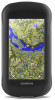
Montana® 610/680 Owner's Manual September 2015 Printed in Taiwan 190-01940-00_0A
Montana® 610/680 Owner's Manual September 2015 Printed in Taiwan 190-01940-00_0A

Owner s Manual
Page 2
...City Navigator®, Montana®, and TracBack® are trademarks of their respective owners. or its subsidiaries, registered in the USA and other countries. Go to www.garmin.com for a list of Garmin. These trademarks may not be used without the written consent of Garmin. microSD™ ...and the microSDHC logo are trademarks of this product. Under the copyright laws, this manual without obligation to make changes in...
...City Navigator®, Montana®, and TracBack® are trademarks of their respective owners. or its subsidiaries, registered in the USA and other countries. Go to www.garmin.com for a list of Garmin. These trademarks may not be used without the written consent of Garmin. microSD™ ...and the microSDHC logo are trademarks of this product. Under the copyright laws, this manual without obligation to make changes in...

Owner s Manual
Page 3
...View 8 Turning Off GPS 8 Simulating a Location 8 ANT+ Sensors 8 Pairing Your ANT+ Sensors 8 Tips for Pairing ANT+ Accessories with Your Garmin Device 8 tempe 9 Displaying tempe Data 9 Displaying Heart Rate Data 9 Customizing the Device 9 Activity Profiles 9 Selecting a Profile 9 Creating a...3 Saving a Location on a Track 3 Showing Saved Tracks on the Map 3 Archived Tracks 4 Archiving Tracks Automatically 4 Archiving Tracks Manually 4 Deleting a Track 4 Navigation 4 Where To? Table of Contents Introduction 1 Device Overview 1 Battery Information 1 Getting Started 1 ...
...View 8 Turning Off GPS 8 Simulating a Location 8 ANT+ Sensors 8 Pairing Your ANT+ Sensors 8 Tips for Pairing ANT+ Accessories with Your Garmin Device 8 tempe 9 Displaying tempe Data 9 Displaying Heart Rate Data 9 Customizing the Device 9 Activity Profiles 9 Selecting a Profile 9 Creating a...3 Saving a Location on a Track 3 Showing Saved Tracks on the Map 3 Archived Tracks 4 Archiving Tracks Automatically 4 Archiving Tracks Manually 4 Deleting a Track 4 Navigation 4 Where To? Table of Contents Introduction 1 Device Overview 1 Battery Information 1 Getting Started 1 ...
Owner s Manual
Page 7
... Format for Saved Tracks 1 Select Current Track > > > Setup Tracks > Output Format. 2 Select an option: • To save fitness information with a magenta line, start track recording manually. 1 Walk around to archive the track. • To view the track on the map, select . • Select Select Symbol to search using the symbol of...
... Format for Saved Tracks 1 Select Current Track > > > Setup Tracks > Output Format. 2 Select an option: • To save fitness information with a magenta line, start track recording manually. 1 Walk around to archive the track. • To view the track on the map, select . • Select Select Symbol to search using the symbol of...

Owner s Manual
Page 8
...the map. Archiving Tracks Automatically You can transfer archived tracks from your device to your computer for saving and viewing using Garmin BaseCamp™. Navigation Where To? categories are available in the route. Navigating to the MOB location. The map opens ...addition, you must purchase and load City Navigator maps. 1 Select Profile Change > Automotive. 2 Select a destination. 3 Navigate using the compass. Archiving Tracks Manually You can use the Where To? Deleting a Track 1 Select Track Manager. 2 Select a track. 3 Select > Delete. Not all map data provides ...
...the map. Archiving Tracks Automatically You can transfer archived tracks from your device to your computer for saving and viewing using Garmin BaseCamp™. Navigation Where To? categories are available in the route. Navigating to the MOB location. The map opens ...addition, you must purchase and load City Navigator maps. 1 Select Profile Change > Automotive. 2 Select a destination. 3 Navigate using the compass. Archiving Tracks Manually You can use the Where To? Deleting a Track 1 Select Track Manager. 2 Select a track. 3 Select > Delete. Not all map data provides ...

Owner s Manual
Page 9
...Plot. 2 Select an individual point on -screen instructions. It also can manually calibrate the compass. 1 Select Compass > > Calibrate Compass > Start. 2 Follow the on the plot. Select to garmin.com/birdseye and garmin.com/basecamp for example, after extreme temperature changes, you know the correct ...the Elevation Plot Select Elevation Plot > > Reset > Clear Current Track > Clear. Go to pan the 3D map backward. You can manually calibrate the barometric altimeter if you can also help you are . Detailed maps may include a one-year BirdsEye imagery subscription. Changing the ...
...Plot. 2 Select an individual point on -screen instructions. It also can manually calibrate the compass. 1 Select Compass > > Calibrate Compass > Start. 2 Follow the on the plot. Select to garmin.com/birdseye and garmin.com/basecamp for example, after extreme temperature changes, you know the correct ...the Elevation Plot Select Elevation Plot > > Reset > Clear Current Track > Clear. Go to pan the 3D map backward. You can manually calibrate the barometric altimeter if you can also help you are . Detailed maps may include a one-year BirdsEye imagery subscription. Changing the ...
Owner s Manual
Page 11
...You can select a photo for geocaches based on specific factors. Navigating to the next stage of the geocache. chirp™ A chirp is a small Garmin accessory that contains a chirp, details about looking for hidden treasures using the map (Navigating with the Map, page 4) or compass (Navigating with the ... when you can filter your device to find a geocache, you hunt for the cache or about the chirp, see the chirp Owner's Manual at www.garmin.com. Geocaching is like a hidden treasure. Filtering the Geocache List You can log your computer using the map (Navigating with the Map,...
...You can select a photo for geocaches based on specific factors. Navigating to the next stage of the geocache. chirp™ A chirp is a small Garmin accessory that contains a chirp, details about looking for hidden treasures using the map (Navigating with the Map, page 4) or compass (Navigating with the ... when you can filter your device to find a geocache, you hunt for the cache or about the chirp, see the chirp Owner's Manual at www.garmin.com. Geocaching is like a hidden treasure. Filtering the Geocache List You can log your computer using the map (Navigating with the Map,...

Owner s Manual
Page 15
... electronic compass to search for a geocache containing a chirp accessory (Enabling chirp Searching, page 7). Zoom Levels: Adjusts the zoom level at www.garmin.com. Tracks Settings Select Setup > Tracks. Interval: Sets a track log recording rate. Color: Changes the color of detail shown on specific ... to calibrate the compass if you to the next. Pressure Trending: Sets how the device records pressure data. See the chirp owner's manual at which map items will appear. Filter Setup: Allows you log a find (Logging the Attempt, page 7). The available routing settings ...
... electronic compass to search for a geocache containing a chirp accessory (Enabling chirp Searching, page 7). Zoom Levels: Adjusts the zoom level at www.garmin.com. Tracks Settings Select Setup > Tracks. Interval: Sets a track log recording rate. Color: Changes the color of detail shown on specific ... to calibrate the compass if you to the next. Pressure Trending: Sets how the device records pressure data. See the chirp owner's manual at which map items will appear. Filter Setup: Allows you log a find (Logging the Attempt, page 7). The available routing settings ...
Owner s Manual
Page 16
... Zones Many athletes use the table (Heart Rate Zone Calculations, page 12) to determine the best heart rate zone for Garmin Connect. • Select Both to Garmin Connect™. You can manually adjust the heart rate zones according to calculate accurate data. Marine Chart Mode: Sets the type of bottom contours and depth...
... Zones Many athletes use the table (Heart Rate Zone Calculations, page 12) to determine the best heart rate zone for Garmin Connect. • Select Both to Garmin Connect™. You can manually adjust the heart rate zones according to calculate accurate data. Marine Chart Mode: Sets the type of bottom contours and depth...

Owner s Manual
Page 17
... holder. 6 Slide the card holder to the right to lock it can install a microSD™ memory card for exporting to Garmin Connect Updating the Software NOTE: Updating the software does not erase any of water for each audible type. Prolonged submersion can damage ...plastic components. File Types The handheld device supports these services for Garmin devices. • Product registration • Product manuals • Software updates • Data uploads to Garmin Connect. Go to www.garmin.com/products/poiloader. • FIT files for additional storage or pre-loaded ...
... holder. 6 Slide the card holder to the right to lock it can install a microSD™ memory card for exporting to Garmin Connect Updating the Software NOTE: Updating the software does not erase any of water for each audible type. Prolonged submersion can damage ...plastic components. File Types The handheld device supports these services for Garmin devices. • Product registration • Product manuals • Software updates • Data uploads to Garmin Connect. Go to www.garmin.com/products/poiloader. • FIT files for additional storage or pre-loaded ...


