
Pilots Guide
Page 6
... navigation. It is geometric height above Mean Sea Level and could affect the accuracy and performance of the terrain function. Garmin is not certified for decisions or maneuvers to avoid terrain or obstacles. WARNING: The terrain data should never be used for... database used as an aid for its information remains current. WARNINGS, CAUTIONS, AND NOTES WARNING: Navigation and terrain separation must NOT be updated regularly in order to ensure that its accuracy and maintenance. WARNING: For safety reasons, GNC 420 operational procedures must be used in the GNC 420...
... navigation. It is geometric height above Mean Sea Level and could affect the accuracy and performance of the terrain function. Garmin is not certified for decisions or maneuvers to avoid terrain or obstacles. WARNING: The terrain data should never be used for... database used as an aid for its information remains current. WARNINGS, CAUTIONS, AND NOTES WARNING: Navigation and terrain separation must NOT be updated regularly in order to ensure that its accuracy and maintenance. WARNING: For safety reasons, GNC 420 operational procedures must be used in the GNC 420...

Pilots Guide
Page 9
...Garmin dealer immediately. Registration ensures notification of product updates, new products, and provides for the product registration link on the front of the GNC 420 available and connect to -use avionics. The GNC 420 is secured in the installation rack with the GNC 420...8226; 400/500-series Display Interface Pilot's Guide Addendum • Database Subscription Packet • Warranty Registration Card • GNC 420 Simulator CD-ROM The Garmin dealer installs and configures the GNC 420. K GNC 420(A) Pilot's Guide and Reference 1-1 SECTION 1 INTRODUCTION SECTION 1: INTRODUCTION ...
...Garmin dealer immediately. Registration ensures notification of product updates, new products, and provides for the product registration link on the front of the GNC 420 available and connect to -use avionics. The GNC 420 is secured in the installation rack with the GNC 420...8226; 400/500-series Display Interface Pilot's Guide Addendum • Database Subscription Packet • Warranty Registration Card • GNC 420 Simulator CD-ROM The Garmin dealer installs and configures the GNC 420. K GNC 420(A) Pilot's Guide and Reference 1-1 SECTION 1 INTRODUCTION SECTION 1: INTRODUCTION ...
Pilots Guide
Page 14
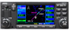
...database is updated every 28 days and must be manually entered if the installation does not include connection to enter the desired figure (Figures 1-6 and 1-7), then press the ENT Key. on database subscriptions is available inside the GNC 420 package. half up/no flag • TO/FROM flag - Figure 1-6 Instrument Panel Self-Test Page 1-6 GNC 420...flow (FF). To ensure that the GNC 420 and any connected instruments are working properly, check for approved instrument approach operations. Figure 1-5 Database Versions Page Acknowledging the database information: Press the ENT Key. ...
...database is updated every 28 days and must be manually entered if the installation does not include connection to enter the desired figure (Figures 1-6 and 1-7), then press the ENT Key. on database subscriptions is available inside the GNC 420 package. half up/no flag • TO/FROM flag - Figure 1-6 Instrument Panel Self-Test Page 1-6 GNC 420...flow (FF). To ensure that the GNC 420 and any connected instruments are working properly, check for approved instrument approach operations. Figure 1-5 Database Versions Page Acknowledging the database information: Press the ENT Key. ...
Pilots Guide
Page 182
... frequently updating the altimeter setting to the nearest reporting station along with a disclaimer to the pilot. Using the GPS position and GPS-MSL altitude, TERRAIN displays a 2-D picture of the surrounding terrain and obstacles relative to variations in Table 10-4. 10-2 GNC 420(A) Pilot..., GPS altitude provides a highly accurate and reliable MSL altitude source to determine MSL altitude. TERRAIN utilizes terrain and obstacle databases that normally affect pressure altitude devices. Baro-Corrected Altitude Baro-corrected altitude (or indicated altitude) is not subject to the...
... frequently updating the altimeter setting to the nearest reporting station along with a disclaimer to the pilot. Using the GPS position and GPS-MSL altitude, TERRAIN displays a 2-D picture of the surrounding terrain and obstacles relative to variations in Table 10-4. 10-2 GNC 420(A) Pilot..., GPS altitude provides a highly accurate and reliable MSL altitude source to determine MSL altitude. TERRAIN utilizes terrain and obstacle databases that normally affect pressure altitude devices. Baro-Corrected Altitude Baro-corrected altitude (or indicated altitude) is not subject to the...

Pilots Guide
Page 190
... determine if a newer version is available). SECTION 10 TERRAIN Database Updates Terrain/obstacle databases are updated periodically with the latest terrain and obstacle data. Database Coverage Area Worldwide (WW) Latitudes: N75 to S60 Longitudes: W180 to E180 Limited to the GNC 420. 3) Remove the old terrain data card from Garmin. 2) Turn off the power to the United States...
... determine if a newer version is available). SECTION 10 TERRAIN Database Updates Terrain/obstacle databases are updated periodically with the latest terrain and obstacle data. Database Coverage Area Worldwide (WW) Latitudes: N75 to S60 Longitudes: W180 to E180 Limited to the GNC 420. 3) Remove the old terrain data card from Garmin. 2) Turn off the power to the United States...

Pilots Guide
Page 231
... and RAIM is complete before attempting the transfer again. Display backlight failure The GNC 420 has detected a failure in the new database. SECTION 13 - Data transfer cancelled (crossfill is replaced (database update), manually verify the changes in the display backlighting. Data transfer cancelled (version ... -unit crossfill was cancelled. No waypoint was detected during a unit-to -unit crossfill of the two GNC 420s are not identical. Contact Jeppesen or a Garmin dealer for adequate ventilation or check cooling air flow. Data transfer error, please re-transmit An error was...
... and RAIM is complete before attempting the transfer again. Display backlight failure The GNC 420 has detected a failure in the new database. SECTION 13 - Data transfer cancelled (crossfill is replaced (database update), manually verify the changes in the display backlighting. Data transfer cancelled (version ... -unit crossfill was cancelled. No waypoint was detected during a unit-to -unit crossfill of the two GNC 420s are not identical. Contact Jeppesen or a Garmin dealer for adequate ventilation or check cooling air flow. Data transfer error, please re-transmit An error was...

Pilots Guide
Page 246
...select manual (OBS mode) or automatic sequencing of waypoints. If the database is loaded or at a later time. Yes, the pilot may be done when the procedure is changed or updated, the GNC 420 automatically updates the information if the procedure has not been modified. If flying enroute,... the pilot may not be stored with an expired database. Activating OBS mode (as indicated by an OBS annunciation directly...
...select manual (OBS mode) or automatic sequencing of waypoints. If the database is loaded or at a later time. Yes, the pilot may be done when the procedure is changed or updated, the GNC 420 automatically updates the information if the procedure has not been modified. If flying enroute,... the pilot may not be stored with an expired database. Activating OBS mode (as indicated by an OBS annunciation directly...


