Owners Manual
Page 8
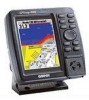
...Programmer • GBR21 Beacon Receiver for your Garmin dealer immediately. For the most recent list of optional transducers, see that your package includes the following items. If any parts are missing, please contact your GPS unit, current user manuals ...garmin.com. GA 22 H-Field Antenna • 2nd Mounting Station • Marine Swivel Mount, 1" RAM® Mount (GPSMAP 188 with your unit, please check to see page 96. Before installing and getting started with external antenna only) vi Introduction Packing List , GPSMAP 188/188C/238 Sounder Standard and Optional Transducers...
...Programmer • GBR21 Beacon Receiver for your Garmin dealer immediately. For the most recent list of optional transducers, see that your package includes the following items. If any parts are missing, please contact your GPS unit, current user manuals ...garmin.com. GA 22 H-Field Antenna • 2nd Mounting Station • Marine Swivel Mount, 1" RAM® Mount (GPSMAP 188 with your unit, please check to see page 96. Before installing and getting started with external antenna only) vi Introduction Packing List , GPSMAP 188/188C/238 Sounder Standard and Optional Transducers...
Owners Manual
Page 24
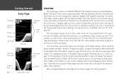
...Symbols' appear as red (strongest), then oranges (strong), yellows (medium), greens (weaker) and blues (weakest). If the unit does not detect a transducer attached to the speed, fish orientation, and/or other half. Those items on the left of the screen contains data fields, while... models, stronger returns appear darker and weaker returns lighter. Actual fish returns may not always appear as they pass under your GPSMAP 188/188C/238 Sounder becomes a powerful fishfinder/ flasher. Along the right side of the screen is an adjustable scale...
...Symbols' appear as red (strongest), then oranges (strong), yellows (medium), greens (weaker) and blues (weakest). If the unit does not detect a transducer attached to the speed, fish orientation, and/or other half. Those items on the left of the screen contains data fields, while... models, stronger returns appear darker and weaker returns lighter. Actual fish returns may not always appear as they pass under your GPSMAP 188/188C/238 Sounder becomes a powerful fishfinder/ flasher. Along the right side of the screen is an adjustable scale...

Owners Manual
Page 36
...of data displayed in data fields on the main pages: • BEARING - Compass ribbon • COURSE - Altitude above/below transducer • DISTANCE TO DESTINATION - Shows estimated GPS accuracy • HIGHWAY - To exit, press QUIT. Desired Track • DEPTH - Distance to final waypoint • ETA AT..., use the ARROW KEYPAD to next waypoint • ELEVATION - Compass direction from your position to next waypoint • GPS ACCURACY - Estimated Time of the Highway Page • MAXIMUM SPEED - Time unit has been moving speed • MOVE TRIP TIME -
...of data displayed in data fields on the main pages: • BEARING - Compass ribbon • COURSE - Altitude above/below transducer • DISTANCE TO DESTINATION - Shows estimated GPS accuracy • HIGHWAY - To exit, press QUIT. Desired Track • DEPTH - Distance to final waypoint • ETA AT..., use the ARROW KEYPAD to next waypoint • ELEVATION - Compass direction from your position to next waypoint • GPS ACCURACY - Estimated Time of the Highway Page • MAXIMUM SPEED - Time unit has been moving speed • MOVE TRIP TIME -

Owners Manual
Page 37
... Reference Map Page Options Highlight the field you wish to change Choose the type of the Temperature Log (if equipped with temperature transducer/ sensor) • WATER TEMPERATURE - LOG - Current time • TIME TO DESTINATION - Current compass direction of travel time of ... • TIME OF DAY - Bearing to next waypoint • TO COURSE - Total travel • TRIP ODOMETER - Current voltage reading being received by unit • WATER SPEED - Time to desired track • TOTAL AVERAGE SPEED - Compressed view of turn needed to your destination •...
... Reference Map Page Options Highlight the field you wish to change Choose the type of the Temperature Log (if equipped with temperature transducer/ sensor) • WATER TEMPERATURE - LOG - Current time • TIME TO DESTINATION - Current compass direction of travel time of ... • TIME OF DAY - Bearing to next waypoint • TO COURSE - Total travel • TRIP ODOMETER - Current voltage reading being received by unit • WATER SPEED - Time to desired track • TOTAL AVERAGE SPEED - Compressed view of turn needed to your destination •...

Owners Manual
Page 45
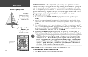
... more detail on the screen. With the Whiteline 'Off', the bottom return displayss as you to control the sensitivity of the unit's receiver. Frequency- Reference Sonar Page: Adjustment Menu View Adjustment Gain Adjustment Target Level Adjustment Whiteline Adjustment Frequency Adjustment 35 View/Span- Target Level-... of the range and reads "Off". To see also page 39) appears on the left side of the sound that the transducer sends and receives. adjusts how dark/light a return (or target) is selected. This setting does not increase/decrease the unit Gain. Once ...
... more detail on the screen. With the Whiteline 'Off', the bottom return displayss as you to control the sensitivity of the unit's receiver. Frequency- Reference Sonar Page: Adjustment Menu View Adjustment Gain Adjustment Target Level Adjustment Whiteline Adjustment Frequency Adjustment 35 View/Span- Target Level-... of the range and reads "Off". To see also page 39) appears on the left side of the sound that the transducer sends and receives. adjusts how dark/light a return (or target) is selected. This setting does not increase/decrease the unit Gain. Once ...

Owners Manual
Page 49
... along the right side of the current Target Level setting (see page 35). You may draw several feet of the graph. Main Menu-Sonar Tab (GPSMAP 188C shown) Depth Scale (Overlay) Color Bar Flasher 39 Map Split Sonar Detail - controls Map Page sonar split range scale. 'Full Range' will flash...'. Enter a positive number to offset for a keel, or enter a negative number to compensate for any reason, the digits in the depth reading. Background Color - (GPSMAP 188C only) sets the background color on the Sonar Page to measure depth from the transducer's location.
... along the right side of the current Target Level setting (see page 35). You may draw several feet of the graph. Main Menu-Sonar Tab (GPSMAP 188C shown) Depth Scale (Overlay) Color Bar Flasher 39 Map Split Sonar Detail - controls Map Page sonar split range scale. 'Full Range' will flash...'. Enter a positive number to offset for a keel, or enter a negative number to compensate for any reason, the digits in the depth reading. Background Color - (GPSMAP 188C only) sets the background color on the Sonar Page to measure depth from the transducer's location.
Owners Manual
Page 50
.... If a ground speed is not available, the top uncalibrated water speed is correct, highlight 'OK' and press ENTER. If you are using a speed-capable transducer/sensor. Bring the boat to the Sonar Tab: 40 1. If the new speed is used instead. Check connections of the display. The unit will automatically... MENU from the calibration screen and choose 'Use Top Ground Speed' to default back to ground speed or 'Use No Calibration' to use the GPS ground speed, if it is not moving or safely increase boat speed. By default, the top ground speed is only available if you wish to...
.... If a ground speed is not available, the top uncalibrated water speed is correct, highlight 'OK' and press ENTER. If you are using a speed-capable transducer/sensor. Bring the boat to the Sonar Tab: 40 1. If the new speed is used instead. Check connections of the display. The unit will automatically... MENU from the calibration screen and choose 'Use Top Ground Speed' to default back to ground speed or 'Use No Calibration' to use the GPS ground speed, if it is not moving or safely increase boat speed. By default, the top ground speed is only available if you wish to...

Owners Manual
Page 94
... log scrolls; Choose from 'Off', 'Auto' (automatically controls filtering), or 'On' (allows you to 255 seconds). • Language - See page 11, starting with a temperature transducer/sensor). averages speed-readings. Reference Main Menu: Temp Tab/ System Tab Time Duration Main Menu-Temp Tab Temperature Scale Main Menu-System Tab (Normal Mode... are available: • Temperature Scale - See pages 42-43. Systm (System) Tab- Select from 'Normal' (Normal Navigation) or 'Simulator' (For practice ONLY), Sounder Only, or GPS Only. See pages 38-40.
... log scrolls; Choose from 'Off', 'Auto' (automatically controls filtering), or 'On' (allows you to 255 seconds). • Language - See page 11, starting with a temperature transducer/sensor). averages speed-readings. Reference Main Menu: Temp Tab/ System Tab Time Duration Main Menu-Temp Tab Temperature Scale Main Menu-System Tab (Normal Mode... are available: • Temperature Scale - See pages 42-43. Systm (System) Tab- Select from 'Normal' (Normal Navigation) or 'Simulator' (For practice ONLY), Sounder Only, or GPS Only. See pages 38-40.

Owners Manual
Page 95
Transducer* - restores all settings to change the position format if you are available: • hddd.ddddd° - The following options: • Defaults - lets you enter a speed. The default format is used to Garmin's original setup values for Position Format, Map Datum, Heading, Distance, Speed,...format you enter a heading. Press MENU for the following additional formats are using a Depth Only, Temp Only, or Temp/Speed transducer. * These fields will only appear when the unit is displayed. The following settings are familiar with. is latitude and ...
Transducer* - restores all settings to change the position format if you are available: • hddd.ddddd° - The following options: • Defaults - lets you enter a speed. The default format is used to Garmin's original setup values for Position Format, Map Datum, Heading, Distance, Speed,...format you enter a heading. Press MENU for the following additional formats are using a Depth Only, Temp Only, or Temp/Speed transducer. * These fields will only appear when the unit is displayed. The following settings are familiar with. is latitude and ...

Owners Manual
Page 101
...re a specified distance or time away from a destination waypoint. You must be receiving sonar data for sounding the alarm and use the control field to sound when the GPS position accuracy falls outside the specified values. sets an alarm to highlight desired submenu ...'Dist' (Distance), or 'Time'. Fish - Highlight the field below , inside or outside the user-set the alarm to sound when the transducer reports a temperature either above, below the alarm name you want the alarm to display and beep until acknowledged, highlight the 'Persist' box and press ...
...re a specified distance or time away from a destination waypoint. You must be receiving sonar data for sounding the alarm and use the control field to sound when the GPS position accuracy falls outside the specified values. sets an alarm to highlight desired submenu ...'Dist' (Distance), or 'Time'. Fish - Highlight the field below , inside or outside the user-set the alarm to sound when the transducer reports a temperature either above, below the alarm name you want the alarm to display and beep until acknowledged, highlight the 'Persist' box and press ...

Owners Manual
Page 106
Proper transducer selection and installation are available from your local dealer or Garmin: • 200/50 kHz, 15/45°, bronze, thru-hull, ..., temp • 200/50 kHz, 15/45°, plastic, in shallow water. A wide cone angle transducer works best in -hull adjustable mount, depth, only • Speed Sensor • Temperature Probe • Thru-hull fairing...cone angle transducer is a 200/50 kHz dual frequency 10/40° cone angle, temperature sensing, transom mount transducer. The larger the cone angle, the larger the coverage area at a given depth. Included in the GPSMAP 188/188C/238 ...
Proper transducer selection and installation are available from your local dealer or Garmin: • 200/50 kHz, 15/45°, bronze, thru-hull, ..., temp • 200/50 kHz, 15/45°, plastic, in shallow water. A wide cone angle transducer works best in -hull adjustable mount, depth, only • Speed Sensor • Temperature Probe • Thru-hull fairing...cone angle transducer is a 200/50 kHz dual frequency 10/40° cone angle, temperature sensing, transom mount transducer. The larger the cone angle, the larger the coverage area at a given depth. Included in the GPSMAP 188/188C/238 ...

Owners Manual
Page 107
... performance. The cable cannot be installed by a professional marine installer. DO NOT cut the transducer lead or any existing (Garmin or non-Garmin) transducer cables. Mount the transducer cable cover well above the waterline. Proper transducer installation is too short, extension cables are available from your Garmin dealer. If the transducer lead is key to any part of the...
... performance. The cable cannot be installed by a professional marine installer. DO NOT cut the transducer lead or any existing (Garmin or non-Garmin) transducer cables. Mount the transducer cable cover well above the waterline. Proper transducer installation is too short, extension cables are available from your Garmin dealer. If the transducer lead is key to any part of the...

Owners Manual
Page 108
...), the boat must be fiberglass, no core (contact your boat manufacturer if you are unsure). Selecting a location: 1. Do not place the transducer over any strakes or behind any air bubbles, laminates, fillers or dead air space. Lightly sand the surface of the hull and face of...98 To avoid drilling a hole to work out any air bubbles. 3. The location has to be used with epoxy inside the hull, placing the transducer on the side bar. Pour about 1/4" tall. If you are unsure if your hull is equipped with a pre-located pocket, contact your hull ...
...), the boat must be fiberglass, no core (contact your boat manufacturer if you are unsure). Selecting a location: 1. Do not place the transducer over any strakes or behind any air bubbles, laminates, fillers or dead air space. Lightly sand the surface of the hull and face of...98 To avoid drilling a hole to work out any air bubbles. 3. The location has to be used with epoxy inside the hull, placing the transducer on the side bar. Pour about 1/4" tall. If you are unsure if your hull is equipped with a pre-located pocket, contact your hull ...

Owners Manual
Page 109
... the boat should power on. Verify that the wiring adapter is possible to perform some checks with the bottom and if necessary, adjust the transducer height until the unit operates correctly. If the unit displays intermittently or fails to get a depth/distance reading when out of the water. ... unit is installed and not blown. It may be in the simulator mode. Press the POWER button and the GPSMAP 188/188C/238 Sounder should be necessary to make sure that the transducer is connected to the correct polarity, and that exceeds 35 VDC, a "Battery Voltage High" warning will turn ...
... the boat should power on. Verify that the wiring adapter is possible to perform some checks with the bottom and if necessary, adjust the transducer height until the unit operates correctly. If the unit displays intermittently or fails to get a depth/distance reading when out of the water. ... unit is installed and not blown. It may be in the simulator mode. Press the POWER button and the GPSMAP 188/188C/238 Sounder should be necessary to make sure that the transducer is connected to the correct polarity, and that exceeds 35 VDC, a "Battery Voltage High" warning will turn ...

Owners Manual
Page 116
...transducer. The unit has lost satellite signals. Contact your dealer or Garmin Customer Service (pg. No Tide Stations For That Area- Contact your dealer or Garmin Customer Service (pg. Antenna Input Shorted To Ground- Input DC voltage is too slow. Check for debris or boat speed is too high for the GPSMAP 188/238 (GPSMAP 188C... 10.0 to 35.0 volts). Contact your dealer or Garmin Customer Service (pg. No DGPS Position- Try another area. Internal problem with the unit...
...transducer. The unit has lost satellite signals. Contact your dealer or Garmin Customer Service (pg. No Tide Stations For That Area- Contact your dealer or Garmin Customer Service (pg. Antenna Input Shorted To Ground- Input DC voltage is too slow. Check for debris or boat speed is too high for the GPSMAP 188/238 (GPSMAP 188C... 10.0 to 35.0 volts). Contact your dealer or Garmin Customer Service (pg. No DGPS Position- Try another area. Internal problem with the unit...

Owners Manual
Page 117
...;ed for new entries. 107 You have used all ten proximity waypoints. Specified shallow water alarm depth has been detected below transducer. Appendix F Messages Track Already Exists: - The oldest track log points were deleted to add more than 254 points to create memory space...and cannot be added until existing ones are removed. Shallow Water Alarm- Route Memory Is Full Can't Create Route- Contact your dealer or Garmin Customer Service (page. Modify the waypoint name or delete the previous waypoint name. Route Already Exists: - You have entered the alarm ...
...;ed for new entries. 107 You have used all ten proximity waypoints. Specified shallow water alarm depth has been detected below transducer. Appendix F Messages Track Already Exists: - The oldest track log points were deleted to add more than 254 points to create memory space...and cannot be added until existing ones are removed. Shallow Water Alarm- Route Memory Is Full Can't Create Route- Contact your dealer or Garmin Customer Service (page. Modify the waypoint name or delete the previous waypoint name. Route Already Exists: - You have entered the alarm ...

Owners Manual
Page 121
...underwater scene as the bottom, a piece of how the unit works and how it can see that it is brief description of how the GPSMAP 188/188C/238 Sounder operates and how it determines what to help you can help improve their fishing productivity. Generally speaking, if the only ...-first on the display. the first strong return sets the bottom level. The transducer collects the reflected sound waves and sends the data to the unit to improve your GPSMAP 188/188C/238 Sounder operates. This section is water, the first strong return will eventually be ...
...underwater scene as the bottom, a piece of how the unit works and how it can see that it is brief description of how the GPSMAP 188/188C/238 Sounder operates and how it determines what to help you can help improve their fishing productivity. Generally speaking, if the only ...-first on the display. the first strong return sets the bottom level. The transducer collects the reflected sound waves and sends the data to the unit to improve your GPSMAP 188/188C/238 Sounder operates. This section is water, the first strong return will eventually be ...

Owners Manual
Page 122
...a "narrow" 10° cone angle, with a coverage width that is determined by the transmitted sound waves is approximately 2/10 of the GPSMAP 188/188C/238 allows you to have a large coverage area and still retain good bottom resolution. As shown, the 10° cone angle (200kHz ...a 50kHz frequency may vary between different types of the water depth. When using the GPSMAP 188/188C/238 in the sidebar, the 40° cone angle (50kHz frequency) approximately covers the area of the transducer and the water depth. Wide Cone Angle Narrow Cone Angle 112 Cone angles may provide...
...a "narrow" 10° cone angle, with a coverage width that is determined by the transmitted sound waves is approximately 2/10 of the GPSMAP 188/188C/238 allows you to have a large coverage area and still retain good bottom resolution. As shown, the 10° cone angle (200kHz ...a 50kHz frequency may vary between different types of the water depth. When using the GPSMAP 188/188C/238 in the sidebar, the 40° cone angle (50kHz frequency) approximately covers the area of the transducer and the water depth. Wide Cone Angle Narrow Cone Angle 112 Cone angles may provide...

Owners Manual
Page 123
On both graphs it was received. Example 2. The unit can be displayed on the graph. It is important to remember that the sonar cannot determine where in the coverage area the ... 1. only when it appears the fish and tree are , only that the returns were received at the same time, but cannot determine where the return originated - Appendix I Understanding the Chart Enlarged Transducer View Branches Fish Enlarged Transducer View Branches Fish ) Remember that the unit does not display a 3-D representation of the underwater environment...
On both graphs it was received. Example 2. The unit can be displayed on the graph. It is important to remember that the sonar cannot determine where in the coverage area the ... 1. only when it appears the fish and tree are , only that the returns were received at the same time, but cannot determine where the return originated - Appendix I Understanding the Chart Enlarged Transducer View Branches Fish Enlarged Transducer View Branches Fish ) Remember that the unit does not display a 3-D representation of the underwater environment...

Owners Manual
Page 130
... 75 Saving 54-55, 76 Showing on Map/Highway 32, 39, 76 Style (monochrome units 55 Track Setup 75-76 Track Up (Map Orientation 30 Transducers 96-99, 112 Trip and Fuel Planning 63 Trip Odometers/Timers 74 U Units Setting 85-86 Understanding Sonar 111-115 Underwater Waypoints 37 W WAAS 69...
... 75 Saving 54-55, 76 Showing on Map/Highway 32, 39, 76 Style (monochrome units 55 Track Setup 75-76 Track Up (Map Orientation 30 Transducers 96-99, 112 Trip and Fuel Planning 63 Trip Odometers/Timers 74 U Units Setting 85-86 Understanding Sonar 111-115 Underwater Waypoints 37 W WAAS 69...

