
GPSMAP 2106/2110 Owner's Manual
Page 4
... Registration v Contact Garmin...v Software License Agreement v Warning ...iv Caution ...iv Getting Started 1 Unit Overview 1 Using the GPSMAP 2106/2110 Keypad 2 Using Soft Keys...3 Using Data Entry/Shortcut Keys 3 Status Bar...3 Turning on the GPSMAP 2106/2110 4 Adjusting the Backlight 4 Initializing the GPS Receiver 5 Receiver Status and Accuracy 6 GPS Setup...6 Using Simulator Mode 7 Basic Operation 8 Using the GPSMAP 2106/2110 8 Selecting Options...
... Registration v Contact Garmin...v Software License Agreement v Warning ...iv Caution ...iv Getting Started 1 Unit Overview 1 Using the GPSMAP 2106/2110 Keypad 2 Using Soft Keys...3 Using Data Entry/Shortcut Keys 3 Status Bar...3 Turning on the GPSMAP 2106/2110 4 Adjusting the Backlight 4 Initializing the GPS Receiver 5 Receiver Status and Accuracy 6 GPS Setup...6 Using Simulator Mode 7 Basic Operation 8 Using the GPSMAP 2106/2110 8 Selecting Options...
GPSMAP 2106/2110 Owner's Manual
Page 5
...Highway Page 41 Changing the Highway Perspective Range 41 Highway Page Options 41 Showing or Hiding Cartography 42 Main Menu 43 GPS Tab...43 Tide Tab ...44 Tide Sub Tab ...44 Current Sub Tab ...46 Celestial Tab 47 Trip Tab...48 ...Tab ...50 Tracks Tab...50 DSC (Digital Selective Calling) Tab 52 Understanding DSC Distress Calls 52 Understanding Position Reports 52 Review DSC Waypoint 53 Setting Up DSC ...54 Using the NAV Key 54 Card Tab ...54 Messages Tab 55 Viewing Detailed ...Tab ...78 General Sub Tab ...79 Graph Sub Tab ...80 Water Temp Sub Tab 81 GPSMAP 2106/2110 Owner's Manual iii
...Highway Page 41 Changing the Highway Perspective Range 41 Highway Page Options 41 Showing or Hiding Cartography 42 Main Menu 43 GPS Tab...43 Tide Tab ...44 Tide Sub Tab ...44 Current Sub Tab ...46 Celestial Tab 47 Trip Tab...48 ...Tab ...50 Tracks Tab...50 DSC (Digital Selective Calling) Tab 52 Understanding DSC Distress Calls 52 Understanding Position Reports 52 Review DSC Waypoint 53 Setting Up DSC ...54 Using the NAV Key 54 Card Tab ...54 Messages Tab 55 Viewing Detailed ...Tab ...78 General Sub Tab ...79 Graph Sub Tab ...80 Water Temp Sub Tab 81 GPSMAP 2106/2110 Owner's Manual iii
GPSMAP 2106/2110 Owner's Manual
Page 18
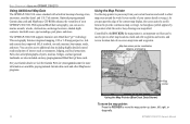
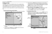
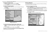
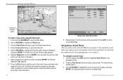
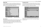
The GPSMAP 2106/2110 supports Garmin's new BlueChart® g2™ technology. You can access marine navaids, wrecks, obstructions, anchorage locations, shaded depth contours, intertidal zones, spot soundings, port plans, and more . An hourglass symbol ... other map locations, mark and edit waypoints and routes, and review location data of interest such as restaurants, lodging, and local attractions. Tide stations. BASIC OPERATION > USING THE GPSMAP 2106/2110 Using Additional Map Data The GPSMAP 2106/2110 comes standard with a built-in basemap showing cities, interstates, ...
The GPSMAP 2106/2110 supports Garmin's new BlueChart® g2™ technology. You can access marine navaids, wrecks, obstructions, anchorage locations, shaded depth contours, intertidal zones, spot soundings, port plans, and more . An hourglass symbol ... other map locations, mark and edit waypoints and routes, and review location data of interest such as restaurants, lodging, and local attractions. Tide stations. BASIC OPERATION > USING THE GPSMAP 2106/2110 Using Additional Map Data The GPSMAP 2106/2110 comes standard with a built-in basemap showing cities, interstates, ...
GPSMAP 2106/2110 Owner's Manual
Page 19
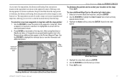
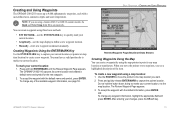
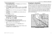
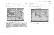
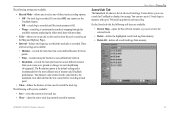
..., allowing you move the pointer to the waypoint or map item. Additional information tabs Map window BASIC OPERATION > USING THE GPSMAP 2106/2110 To eliminate the pointer and re-center your boat moves. Press QUIT to view the information and additional options. Viewing Additional Information... (BlueChart Data Shown) GPSMAP 2106/2110 Owner's Manual 11 The map pointer can also be used to snap to on the Review Waypoint Page. Use the ROCKER to highlight the individual tabs to exit. A chart summary...
..., allowing you move the pointer to the waypoint or map item. Additional information tabs Map window BASIC OPERATION > USING THE GPSMAP 2106/2110 To eliminate the pointer and re-center your boat moves. Press QUIT to view the information and additional options. Viewing Additional Information... (BlueChart Data Shown) GPSMAP 2106/2110 Owner's Manual 11 The map pointer can also be used to snap to on the Review Waypoint Page. Use the ROCKER to highlight the individual tabs to exit. A chart summary...
GPSMAP 2106/2110 Owner's Manual
Page 20
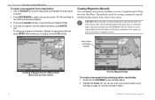
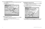
... Name tab. Enter data, as needed, to spell out the name, or scroll through the list. 12 Chart name Distance and bearing Soft keys GPSMAP 2106/2110 Owner's Manual The Find From (Location) Page appears. 2. For By Name, select the top field to narrow your current location: 1.... an Item Press FIND to search for creating a waypoint or viewing the next item in the search results list, and press ENTER. The Review Page appears, showing item information, map location, chart name, distance/bearing, and options for items including waypoints, cities, geographic points, celestial ...
... Name tab. Enter data, as needed, to spell out the name, or scroll through the list. 12 Chart name Distance and bearing Soft keys GPSMAP 2106/2110 Owner's Manual The Find From (Location) Page appears. 2. For By Name, select the top field to narrow your current location: 1.... an Item Press FIND to search for creating a waypoint or viewing the next item in the search results list, and press ENTER. The Review Page appears, showing item information, map location, chart name, distance/bearing, and options for items including waypoints, cities, geographic points, celestial ...
GPSMAP 2106/2110 Owner's Manual
Page 21
...location, not the map location. Use the ROCKER to define a new waypoint location. • Manually-enter new waypoint coordinates manually. The Review Waypoint Page appears. 3. You can create a waypoint by using three basic methods: • ENTER/MARK-use the map display to move the ...information, press ENTER. To create a new waypoint using a Garmin GSD 21 or GSD 22 sounder module, the Depth and Water Temp fields fill in automatically. To change any map location or map feature. GPSMAP 2106/2110 Owner's Manual 13 Creating Waypoints Using the ENTER/MARK Key...
...location, not the map location. Use the ROCKER to define a new waypoint location. • Manually-enter new waypoint coordinates manually. The Review Waypoint Page appears. 3. You can create a waypoint by using three basic methods: • ENTER/MARK-use the map display to move the ...information, press ENTER. To create a new waypoint using a Garmin GSD 21 or GSD 22 sounder module, the Depth and Water Temp fields fill in automatically. To change any map location or map feature. GPSMAP 2106/2110 Owner's Manual 13 Creating Waypoints Using the ENTER/MARK Key...
GPSMAP 2106/2110 Owner's Manual
Page 22
... information, press ENTER. BASIC OPERATION > CREATING AND USING WAYPOINTS To create a new waypoint from a Map Feature (BlueChart g2 Data shown) 14 Review Waypoint Page To create a new waypoint by entering position coordinates: 1. Use the ROCKER to create a waypoint using the steps on the Main Menu... CAUTION: When entering a waypoint manually, be sure that the unit is set to capture the pointer location. Entering coordinates into the GPSMAP 2106/2110 while it is set to step 4. You can result in which the coordinates were created can also mark your changes, press the ...
... information, press ENTER. BASIC OPERATION > CREATING AND USING WAYPOINTS To create a new waypoint from a Map Feature (BlueChart g2 Data shown) 14 Review Waypoint Page To create a new waypoint by entering position coordinates: 1. Use the ROCKER to create a waypoint using the steps on the Main Menu... CAUTION: When entering a waypoint manually, be sure that the unit is set to capture the pointer location. Entering coordinates into the GPSMAP 2106/2110 while it is set to step 4. You can result in which the coordinates were created can also mark your changes, press the ...
GPSMAP 2106/2110 Owner's Manual
Page 23
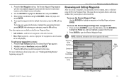
...Wpt (waypoint)-moves or projects the waypoint to the route. Waypoint name Symbol Comment Position Coordinates Depth/water temp Map window GPSMAP 2106/2110 Owner's Manual Review Waypoint Page 15 Press the Add To Route soft key. The Select Route Page appears. 2. Highlight a route or New...waypoint with the next available waypoint number and the receiver's last known location as the default name and location. 4. BASIC OPERATION > REVIEWING AND EDITING WAYPOINTS Reviewing and Editing Waypoints After you create a waypoint, you can modify, review, rename, move, or delete it using the ...
...Wpt (waypoint)-moves or projects the waypoint to the route. Waypoint name Symbol Comment Position Coordinates Depth/water temp Map window GPSMAP 2106/2110 Owner's Manual Review Waypoint Page 15 Press the Add To Route soft key. The Select Route Page appears. 2. Highlight a route or New...waypoint with the next available waypoint number and the receiver's last known location as the default name and location. 4. BASIC OPERATION > REVIEWING AND EDITING WAYPOINTS Reviewing and Editing Waypoints After you create a waypoint, you can modify, review, rename, move, or delete it using the ...
GPSMAP 2106/2110 Owner's Manual
Page 24
... Wpt soft key. The distance and bearing from its present location to the new location. Waypoint Symbol List To change the waypoint name: 1. BASIC OPERATION > REVIEWING AND EDITING WAYPOINTS To change the Comment, Position, Depth, or Water temp: 1. Highlight the waypoint name field, and press ENTER. 2. To move the waypoint... waypoint's current location appears in or out on the map: 1. Highlight the waypoint symbol field to move the waypoint on the map window the Review Waypoint Page: Press the Zoom Up or Zoom Down keys. 16 GPSMAP 2106/2110 Owner's Manual
... Wpt soft key. The distance and bearing from its present location to the new location. Waypoint Symbol List To change the waypoint name: 1. BASIC OPERATION > REVIEWING AND EDITING WAYPOINTS To change the Comment, Position, Depth, or Water temp: 1. Highlight the waypoint name field, and press ENTER. 2. To move the waypoint... waypoint's current location appears in or out on the map: 1. Highlight the waypoint symbol field to move the waypoint on the map window the Review Waypoint Page: Press the Zoom Up or Zoom Down keys. 16 GPSMAP 2106/2110 Owner's Manual

GPSMAP 2106/2110 Owner's Manual
Page 25
...by page. 3. The next waypoint in the list is automatically highlighted. Stored waypoints are shown at the bottom of waypoints; NOTE: When you can review, edit, rename, or delete individual waypoints, or delete all waypoints from the Main Menu: 1. To scroll through the list of the User sub ...was used waypoints are arranged in alphanumeric order. press right or left on the Main Menu, and then highlight the User sub tab. 2. GPSMAP 2106/2110 Owner's Manual 17 To access the Points tab from the unit. Use the ROCKER to open the Main Menu. 2. Deleting Waypoints The ...
...by page. 3. The next waypoint in the list is automatically highlighted. Stored waypoints are shown at the bottom of waypoints; NOTE: When you can review, edit, rename, or delete individual waypoints, or delete all waypoints from the Main Menu: 1. To scroll through the list of the User sub ...was used waypoints are arranged in alphanumeric order. press right or left on the Main Menu, and then highlight the User sub tab. 2. GPSMAP 2106/2110 Owner's Manual 17 To access the Points tab from the unit. Use the ROCKER to open the Main Menu. 2. Deleting Waypoints The ...

GPSMAP 2106/2110 Owner's Manual
Page 26
... you are alerted only to delete, and press ENTER. 4. Press the Delete By Symbol soft key. 3. Proximity circle Proximity waypoint 18 GPSMAP 2106/2110 Owner's Manual You can help you want to delete. 2. A confirmation message appears. 2. To delete all user waypoints. Highlight ... "Proximity Overlaps Another Proximity Waypoint" appears. The alarm circle can add proximity alarms to delete all user waypoints: 1. BASIC OPERATION > REVIEWING AND EDITING WAYPOINTS To delete a single waypoint from the User sub tab: 1. On the User sub tab, highlight the waypoint you ...
... you are alerted only to delete, and press ENTER. 4. Press the Delete By Symbol soft key. 3. Proximity circle Proximity waypoint 18 GPSMAP 2106/2110 Owner's Manual You can help you want to delete. 2. A confirmation message appears. 2. To delete all user waypoints. Highlight ... "Proximity Overlaps Another Proximity Waypoint" appears. The alarm circle can add proximity alarms to delete all user waypoints: 1. BASIC OPERATION > REVIEWING AND EDITING WAYPOINTS To delete a single waypoint from the User sub tab: 1. On the User sub tab, highlight the waypoint you ...
GPSMAP 2106/2110 Owner's Manual
Page 27
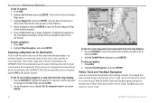
..., or press QUIT to highlight a waypoint or map item, and press ENTER. The Find From Current Position Page appears. 2. The Review Page appears for selecting a destination is the Go To function, which allows you see a straight line on the Proximity sub tab, ...rmation message appears. 3. BASIC OPERATION > NAVIGATING TO A DESTINATION Navigating to a Destination Using the NAV key, the GPSMAP 2106/2110 provides four ways to navigate to a Destination GPSMAP 2106/2110 Owner's Manual 19 If you want to the destination. Current location Destination Navigating to a destination: Go To Point,...
..., or press QUIT to highlight a waypoint or map item, and press ENTER. The Find From Current Position Page appears. 2. The Review Page appears for selecting a destination is the Go To function, which allows you see a straight line on the Proximity sub tab, ...rmation message appears. 3. BASIC OPERATION > NAVIGATING TO A DESTINATION Navigating to a Destination Using the NAV key, the GPSMAP 2106/2110 provides four ways to navigate to a Destination GPSMAP 2106/2110 Owner's Manual 19 If you want to the destination. Current location Destination Navigating to a destination: Go To Point,...
GPSMAP 2106/2110 Owner's Manual
Page 28
...2. Highlight Waypoints, and press ENTER. (You can be stored or saved in the same way. Press the Go To soft key to open the Review Waypoint Page for the selected waypoint. 5. A magenta line appears on the Map Page, and press NAV. 2. On the Navigation menu, highlight Go ... new map point. TracBack uses your present location to select one of three items from this list, such as the Go To destination, the GPSMAP 2106/2110 automatically creates a waypoint named MAP at the pointer location. Highlight Stop Navigation, and press ENTER. Press NAV. 2. Highlight Stop Navigation, and ...
...2. Highlight Waypoints, and press ENTER. (You can be stored or saved in the same way. Press the Go To soft key to open the Review Waypoint Page for the selected waypoint. 5. A magenta line appears on the Map Page, and press NAV. 2. On the Navigation menu, highlight Go ... new map point. TracBack uses your present location to select one of three items from this list, such as the Go To destination, the GPSMAP 2106/2110 automatically creates a waypoint named MAP at the pointer location. Highlight Stop Navigation, and press ENTER. Press NAV. 2. Highlight Stop Navigation, and ...
GPSMAP 2106/2110 Owner's Manual
Page 30
... Select Track Page appears. 2. Highlight the track you want to Resolution for best performance). • If the receiver is turned off or satellite coverage is active, the GPSMAP 2106/2110 takes the track log stored in the reverse direction), press NAV, highlight Invert Route, and press ENTER. TracBack Tips...track before using the Follow Track option. To change the name of the track log to open the Navigation menu. 2. To review and edit a track: 1. The receiver then assigns the 300 waypoints to show the track on the track log setup page must be set to Fill or Wrap. ...
... Select Track Page appears. 2. Highlight the track you want to Resolution for best performance). • If the receiver is turned off or satellite coverage is active, the GPSMAP 2106/2110 takes the track log stored in the reverse direction), press NAV, highlight Invert Route, and press ENTER. TracBack Tips...track before using the Follow Track option. To change the name of the track log to open the Navigation menu. 2. To review and edit a track: 1. The receiver then assigns the 300 waypoints to show the track on the track log setup page must be set to Fill or Wrap. ...
GPSMAP 2106/2110 Owner's Manual
Page 32
... the end point back to open the Route list. 5. From any page, press NAV, and then highlight Follow Route on the Map Page. 24 GPSMAP 2106/2110 Owner's Manual Use the ROCKER to highlight the route you add each new waypoint to the route, the Route list shows the waypoint or map... show other points, such as it . Use the ROCKER to the Route Page. Press the Use List soft key to navigate, and press ENTER. The Review Waypoint Page appears. 8. As you want to open the Route map window. 4. Navigating a Saved Route After you create a route, press the NAV key to open...
... the end point back to open the Route list. 5. From any page, press NAV, and then highlight Follow Route on the Map Page. 24 GPSMAP 2106/2110 Owner's Manual Use the ROCKER to highlight the route you add each new waypoint to the route, the Route list shows the waypoint or map... show other points, such as it . Use the ROCKER to the Route Page. Press the Use List soft key to navigate, and press ENTER. The Review Waypoint Page appears. 8. As you want to open the Route map window. 4. Navigating a Saved Route After you create a route, press the NAV key to open...
GPSMAP 2106/2110 Owner's Manual
Page 35
...On the Routes tab, highlight the route you want to a route: 1. The selected route leg turns yellow. To review individual route points on the Review Waypoint Page. 3. Highlight a point on the route list. The map window opens, showing the selected route. 2. The... color of the waypoint properties on the map: 1. Route leg to magenta and the word "ADD" appears below the map pointer. The map window opens showing the selected route. 2. GPSMAP 2106/2110...
...On the Routes tab, highlight the route you want to a route: 1. The selected route leg turns yellow. To review individual route points on the Review Waypoint Page. 3. Highlight a point on the route list. The map window opens, showing the selected route. 2. The... color of the waypoint properties on the map: 1. Route leg to magenta and the word "ADD" appears below the map pointer. The map window opens showing the selected route. 2. GPSMAP 2106/2110...
GPSMAP 2106/2110 Owner's Manual
Page 36
Press ENTER to add the point to review (waypoint or map item). 3. Press the Move soft key to add a route point. 5. The word "MOVE" appears below the map pointer. The map window opens ... press the Remove soft key. 4. The map window opens showing the selected route. 2. Select the point you want to move the route point. 28 GPSMAP 2106/2110 Owner's Manual Use the ROCKER to drag the map pointer to the location where you want to remove from a route: 1. Use the ROCKER to drag...
Press ENTER to add the point to review (waypoint or map item). 3. Press the Move soft key to add a route point. 5. The word "MOVE" appears below the map pointer. The map window opens ... press the Remove soft key. 4. The map window opens showing the selected route. 2. Select the point you want to move the route point. 28 GPSMAP 2106/2110 Owner's Manual Use the ROCKER to drag the map pointer to the location where you want to remove from a route: 1. Use the ROCKER to drag...
GPSMAP 2106/2110 Owner's Manual
Page 49
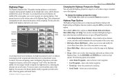
... which direction you are navigating a route, the Highway Page shows each waypoint of the active route. • Edit Active Route (Edit Route)-allows you to review and modify the Active Route from either a list of the route points or on a map. • Show (Hide) Map-allows you to show or ...hide the map on the Highway Page. • Setup-allows you to your course. GPSMAP 2106/2110 Owner's Manual MAIN PAGES > HIGHWAY PAGE Changing the Highway Perspective Range You can zoom the highway perspective range in the active route, Track Log points...
... which direction you are navigating a route, the Highway Page shows each waypoint of the active route. • Edit Active Route (Edit Route)-allows you to review and modify the Active Route from either a list of the route points or on a map. • Show (Hide) Map-allows you to show or ...hide the map on the Highway Page. • Setup-allows you to your course. GPSMAP 2106/2110 Owner's Manual MAIN PAGES > HIGHWAY PAGE Changing the Highway Perspective Range You can zoom the highway perspective range in the active route, Track Log points...
GPSMAP 2106/2110 Owner's Manual
Page 57
... at the bottom of 99.99 nautical or statute miles or kilometers. The sub tabs also provide continuously updated proximity waypoint alarms that can review, edit, rename, or delete individual waypoints, or delete all waypoints currently stored in alphanumeric order. The total number of stored and available ... TAB Proximity Sub Tab Use the Proximity sub tab on the Points tab displays a master list of waypoints quickly and efficiently. GPSMAP 2106/2110 Owner's Manual 49 The alarm circle can help you can be used waypoints User Sub Tab The User sub tab on the Points tab...
... at the bottom of 99.99 nautical or statute miles or kilometers. The sub tabs also provide continuously updated proximity waypoint alarms that can review, edit, rename, or delete individual waypoints, or delete all waypoints currently stored in alphanumeric order. The total number of stored and available ... TAB Proximity Sub Tab Use the Proximity sub tab on the Points tab displays a master list of waypoints quickly and efficiently. GPSMAP 2106/2110 Owner's Manual 49 The alarm circle can help you can be used waypoints User Sub Tab The User sub tab on the Points tab...
GPSMAP 2106/2110 Owner's Manual
Page 59
...The distance value (entered in the value field) is recorded. On the Saved sub tab, the following soft keys are available: • Review Map-opens the Saved Track window so you to use a track for the most efficient use the TracBack feature. • Fill-a track ...track plot based on a user-defined variance from memory. You can review the selected track. • Delete-deletes the highlighted saved track log from memory. • Delete All-deletes all saved track logs. GPSMAP 2106/2110 Owner's Manual 51 The following settings are available: • Record Mode-allows...
...The distance value (entered in the value field) is recorded. On the Saved sub tab, the following soft keys are available: • Review Map-opens the Saved Track window so you to use a track for the most efficient use the TracBack feature. • Fill-a track ...track plot based on a user-defined variance from memory. You can review the selected track. • Delete-deletes the highlighted saved track log from memory. • Delete All-deletes all saved track logs. GPSMAP 2106/2110 Owner's Manual 51 The following settings are available: • Record Mode-allows...