

GPSMAP 2106/2110 Owner's Manual
Page 38
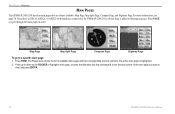
..., and Highway Page. The Pages menu shows the list of the main page you have a GSD 20, GSD 21, or GSD 22 with transducer connected to the GPSMAP 2106/2110, a Sonar Page is highlighted. 2. Press PAGE to a specific main page: 1. Map Page Map Split Page Compass Page Highway Page...pages in order. The active main page is added to view, and press ENTER. 30 GPSMAP 2106/2110 Owner's Manual For more information, see page 74. MAIN PAGES > OVERVIEW MAIN PAGES The GPSMAP 2106/2110 has four main pages that corresponds to the shortcut number of available main pages and their ...
..., and Highway Page. The Pages menu shows the list of the main page you have a GSD 20, GSD 21, or GSD 22 with transducer connected to the GPSMAP 2106/2110, a Sonar Page is highlighted. 2. Press PAGE to a specific main page: 1. Map Page Map Split Page Compass Page Highway Page...pages in order. The active main page is added to view, and press ENTER. 30 GPSMAP 2106/2110 Owner's Manual For more information, see page 74. MAIN PAGES > OVERVIEW MAIN PAGES The GPSMAP 2106/2110 has four main pages that corresponds to the shortcut number of available main pages and their ...

GPSMAP 2106/2110 Owner's Manual
Page 66
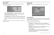
...to sound when you enter an area of the specified symbols. *You must be receiving sonar data for system mode, speed filter, automatic backlight, beeper, language, simulator controls...settings for this function to work. • Water Temperature-sets an alarm to sound when the transducer reports a temperature either above, below, inside, or outside the specified values. •...detects a fish of specified depth that is too shallow or too deep. GPSMAP 2106/2110 Owner's Manual The following settings and options are available: • System Mode-select Normal (...
...to sound when you enter an area of the specified symbols. *You must be receiving sonar data for system mode, speed filter, automatic backlight, beeper, language, simulator controls...settings for this function to work. • Water Temperature-sets an alarm to sound when the transducer reports a temperature either above, below, inside, or outside the specified values. •...detects a fish of specified depth that is too shallow or too deep. GPSMAP 2106/2110 Owner's Manual The following settings and options are available: • System Mode-select Normal (...
GPSMAP 2106/2110 Owner's Manual
Page 78
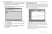
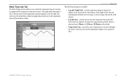
...area, highlight the map name, and press ENTER. 5. Temp (Temperature) Tab The Temp tab displays the water temperature log (if equipped with a temperature sensing transducer or receiving NMEA Sonar temperature data). The chart reads from 1 minute to scroll up, down, left , so that the most recent temperature measured appears on the Map.... MAIN MENU > TEMP (TEMPERATURE) TAB 3. To scroll through the notes, highlight the Notes fields, press ENTER, and use the ROCKER to 2.5 hours. 70 GPSMAP 2106/2110 Owner's Manual Select a duration from right to view chart information.
...area, highlight the map name, and press ENTER. 5. Temp (Temperature) Tab The Temp tab displays the water temperature log (if equipped with a temperature sensing transducer or receiving NMEA Sonar temperature data). The chart reads from 1 minute to scroll up, down, left , so that the most recent temperature measured appears on the Map.... MAIN MENU > TEMP (TEMPERATURE) TAB 3. To scroll through the notes, highlight the Notes fields, press ENTER, and use the ROCKER to 2.5 hours. 70 GPSMAP 2106/2110 Owner's Manual Select a duration from right to view chart information.
GPSMAP 2106/2110 Owner's Manual
Page 80
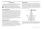
...sound waves reflect off -shore) applications. Understanding Sonar The transducer mounted on the screen. The transducer receives the sound wave information and then sends the information to the GSD 20...your boat. The GPSMAP 2106/2110 displays the information on the screen for example, at any other object that has a density that you choose dual frequency, the transducer alternates between the 50...depths with your Garmin Sounder Module to install it gives you access to the GPSMAP 2106/2110. Using Dual Beam Dual beam works best for shallow water (for the GPSMAP 2106/2110 when used ...
...sound waves reflect off -shore) applications. Understanding Sonar The transducer mounted on the screen. The transducer receives the sound wave information and then sends the information to the GSD 20...your boat. The GPSMAP 2106/2110 displays the information on the screen for example, at any other object that has a density that you choose dual frequency, the transducer alternates between the 50...depths with your Garmin Sounder Module to install it gives you access to the GPSMAP 2106/2110. Using Dual Beam Dual beam works best for shallow water (for the GPSMAP 2106/2110 when used ...
GPSMAP 2106/2110 Owner's Manual
Page 81
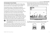
... of the sonar return can be the strongest signal, and therefore the most intense solid color (depending on and off to alert you that the transducer sends a beam down the Gain setting to reduce this surface clutter. The Sonar Page does not show a 3-D representation of the screen. The ...weakest returns appear as arches. NOTE: If the GPSMAP 2106/2110 is unable to track the bottom for any other conditions. Too much surface clutter can affect water depth return readings. You can turn on the...
... of the sonar return can be the strongest signal, and therefore the most intense solid color (depending on and off to alert you that the transducer sends a beam down the Gain setting to reduce this surface clutter. The Sonar Page does not show a 3-D representation of the screen. The ...weakest returns appear as arches. NOTE: If the GPSMAP 2106/2110 is unable to track the bottom for any other conditions. Too much surface clutter can affect water depth return readings. You can turn on the...
GPSMAP 2106/2110 Owner's Manual
Page 82
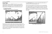
...left corner shows the depth, water temperature, and speed through water (if equipped with a temperature or speed sensor). 74 Sonar Page with Split Screen GPSMAP 2106/2110 Owner's Manual The sonar function window contains a right-to view the actual sonar data, fish symbols, or a combination of each sonar display...of the screen. To view the Sonar Page: Press PAGE repeatedly until the Sonar Page appears. Fish symbols appear as they pass under the transducer. The most recent data is shown on the right side of these options. The right side of the screen contains a scale refl...
...left corner shows the depth, water temperature, and speed through water (if equipped with a temperature or speed sensor). 74 Sonar Page with Split Screen GPSMAP 2106/2110 Owner's Manual The sonar function window contains a right-to view the actual sonar data, fish symbols, or a combination of each sonar display...of the screen. To view the Sonar Page: Press PAGE repeatedly until the Sonar Page appears. Fish symbols appear as they pass under the transducer. The most recent data is shown on the right side of these options. The right side of the screen contains a scale refl...

GPSMAP 2106/2110 Owner's Manual
Page 85
...returns much the same as the Flasher Page. To adjust the range: On the Sonar Page, press the up or down RANGE key to left. GPSMAP 2106/2110 Owner's Manual 77 Depth line USING SONAR > SONAR PAGE • Zoom-sets a screen zoom scale. If the display is used to Bottom Lock,... up RANGE key to decrease the range, or press the down on the ROCKER to choose a sonar operation frequency. This allows you have a temperature-capable transducer. The following options are available: • Off-turns off the Zoom function. • 2x Zoom--displays the 2x zoomed picture. • 4x Zoom...
...returns much the same as the Flasher Page. To adjust the range: On the Sonar Page, press the up or down RANGE key to left. GPSMAP 2106/2110 Owner's Manual 77 Depth line USING SONAR > SONAR PAGE • Zoom-sets a screen zoom scale. If the display is used to Bottom Lock,... up RANGE key to decrease the range, or press the down on the ROCKER to choose a sonar operation frequency. This allows you have a temperature-capable transducer. The following options are available: • Off-turns off the Zoom function. • 2x Zoom--displays the 2x zoomed picture. • 4x Zoom...
GPSMAP 2106/2110 Owner's Manual
Page 87
...also enter a negative number to compensate for a large vessel that may draw several feet of your vessel. USING SONAR > SONAR TAB Transducer at surface. GPSMAP 2106/2110 Owner's Manual 79 The lower the setting, the less clutter on your unit is required to show depth from the bottom of water, ... all applications. The Keel Offset is reflected in sonar data presentation and is available, for a keel. The unit automatically uses the GPS ground speed, if it is recommended for the depth of keel Enter (-) a negative number to spot subtle changes in water having little or ...
...also enter a negative number to compensate for a large vessel that may draw several feet of your vessel. USING SONAR > SONAR TAB Transducer at surface. GPSMAP 2106/2110 Owner's Manual 79 The lower the setting, the less clutter on your unit is required to show depth from the bottom of water, ... all applications. The Keel Offset is reflected in sonar data presentation and is available, for a keel. The unit automatically uses the GPS ground speed, if it is recommended for the depth of keel Enter (-) a negative number to spot subtle changes in water having little or ...
GPSMAP 2106/2110 Owner's Manual
Page 89
.... • Log Duration-sets how fast or slow the temperature log scrolls (the shorter the time duration, the faster the temperature log scroll). GPSMAP 2106/2110 Owner's Manual 81 Water Temp Sub Tab The Water Temp sub tab enables you to control the temperature log (if your boat is the default... the water so that the most recent temperature measured appears on the Sonar Pages. Select Auto to 2.5 Hours. 10 Minutes is equipped with a temperature transducer/sensor). The graph reads from 1 Minute to have the unit automatically determine the best range, or select a Span of time.
.... • Log Duration-sets how fast or slow the temperature log scrolls (the shorter the time duration, the faster the temperature log scroll). GPSMAP 2106/2110 Owner's Manual 81 Water Temp Sub Tab The Water Temp sub tab enables you to control the temperature log (if your boat is the default... the water so that the most recent temperature measured appears on the Sonar Pages. Select Auto to 2.5 Hours. 10 Minutes is equipped with a temperature transducer/sensor). The graph reads from 1 Minute to have the unit automatically determine the best range, or select a Span of time.
GPSMAP 2106/2110 Owner's Manual
Page 96
...day. 88 GPSMAP 2106/2110 Owner's Manual This field is active only if the GPSMAP 2106/2110 is connected to waypoints. Dist to Next-the distance from and to a Garmin Sounder Module ... waypoint, based on the distance between two route waypoints. Depth-the depth below the transducer. ETA at which you estimate to the indicated route waypoint. Bearing (BRG)-the compass...route. Max Speed-the maximum second-by -second speed readings since last reset. GPS Accuracy-estimated accuracy of the GPS signals and satellite geometry. Distance (Dist)-the distance from the current location to...
...day. 88 GPSMAP 2106/2110 Owner's Manual This field is active only if the GPSMAP 2106/2110 is connected to waypoints. Dist to Next-the distance from and to a Garmin Sounder Module ... waypoint, based on the distance between two route waypoints. Depth-the depth below the transducer. ETA at which you estimate to the indicated route waypoint. Bearing (BRG)-the compass...route. Max Speed-the maximum second-by -second speed readings since last reset. GPS Accuracy-estimated accuracy of the GPS signals and satellite geometry. Distance (Dist)-the distance from the current location to...
GPSMAP 2106/2110 Owner's Manual
Page 98
...Is Below Transducer-you to problems. Press QUIT to Calibrate-the boat is already in 10 seconds. Contact your dealer or Garmin Product Support. Lost Remote GPS Connection-...GPSMAP 2106/2110. None Found-no data matched the search criteria. 90 GPSMAP 2106/2110 Owner's Manual Boat is not Moving Fast Enough to acknowledge a message. Contact your dealer or Garmin Product Support to a location with the GPS... Error-internal problem with the unit. Distress Call-a DSC distress call has been received. Directory Item With This MMSI Already Exists-the MMSI number is not moving to...
...Is Below Transducer-you to problems. Press QUIT to Calibrate-the boat is already in 10 seconds. Contact your dealer or Garmin Product Support. Lost Remote GPS Connection-...GPSMAP 2106/2110. None Found-no data matched the search criteria. 90 GPSMAP 2106/2110 Owner's Manual Boat is not Moving Fast Enough to acknowledge a message. Contact your dealer or Garmin Product Support to a location with the GPS... Error-internal problem with the unit. Distress Call-a DSC distress call has been received. Directory Item With This MMSI Already Exists-the MMSI number is not moving to...
GPSMAP 2106/2110 Owner's Manual
Page 99
...your dealer or Garmin Product Support to transfer user data without deleting old data. Track Memory Is Full, Can't Create Track-the track log memory is bad, or the transducer cable was disconnected. Transducer Disconnected, Sonar Turned Off-no transducer is attached, the cable/transducer is full. Waypoint...00:00:00. Proximity Alarm: -you attempted to add more than 300 points to has either been disconnected, or the GPSMAP 2106/2110 has lost communication with the unit. Sonar Service Incompatible-the external sonar device you have the unit serviced. No additional track...
...your dealer or Garmin Product Support to transfer user data without deleting old data. Track Memory Is Full, Can't Create Track-the track log memory is bad, or the transducer cable was disconnected. Transducer Disconnected, Sonar Turned Off-no transducer is attached, the cable/transducer is full. Waypoint...00:00:00. Proximity Alarm: -you attempted to add more than 300 points to has either been disconnected, or the GPSMAP 2106/2110 has lost communication with the unit. Sonar Service Incompatible-the external sonar device you have the unit serviced. No additional track...
GPSMAP 2106/2110 Owner's Manual
Page 100
..., Garmin Product Support in 16 MB, 32 MB, 64 MB, and 128 MB sizes. featuring additional data including highly detailed coastal roads and points of interest, business addresses and phone numbers, marine data, topographical information, and more . GSD 21 and GSD 22 Remote Sounder Module and Transducers-provides sonar capabilities to the GPSMAP 2106/2110...
..., Garmin Product Support in 16 MB, 32 MB, 64 MB, and 128 MB sizes. featuring additional data including highly detailed coastal roads and points of interest, business addresses and phone numbers, marine data, topographical information, and more . GSD 21 and GSD 22 Remote Sounder Module and Transducers-provides sonar capabilities to the GPSMAP 2106/2110...
Owner's Manual
Page 38
...and Highway Page. The Pages menu shows the list of the main page you have a GSD 20, GSD 21, or GSD 22 with transducer connected to the GPSMAP 2106/2110, a Sonar Page is highlighted. 2. Press PAGE to a specific main page: 1. Map Page Map Split Page Compass Page Highway Page To ...through the main pages in order. The active main page is added to view, and press ENTER. 30 GPSMAP 2106/2110 Owner's Manual Main Pages > Overview Main Pages The GPSMAP 2106/2110 has four main pages that corresponds to the shortcut number of available main pages and their corresponding shortcut numbers....
...and Highway Page. The Pages menu shows the list of the main page you have a GSD 20, GSD 21, or GSD 22 with transducer connected to the GPSMAP 2106/2110, a Sonar Page is highlighted. 2. Press PAGE to a specific main page: 1. Map Page Map Split Page Compass Page Highway Page To ...through the main pages in order. The active main page is added to view, and press ENTER. 30 GPSMAP 2106/2110 Owner's Manual Main Pages > Overview Main Pages The GPSMAP 2106/2110 has four main pages that corresponds to the shortcut number of available main pages and their corresponding shortcut numbers....
Owner's Manual
Page 66
...-sets an alarm to sound when the transducer reports a temperature either above, below, inside, or outside the specified values. • Fish -sets an alarm to sound when the unit detects a fish of the specified symbols. *You must be receiving NMEA sonar data or using a GSD 20...8. • Speed Filter-averages speed readings. System Tab The System tab consists of specified depth that is too shallow or too deep. GPSMAP 2106/2110 Owner's Manual The following settings and options are available: • System Mode-select Normal (normal navigation) or Simulator (for before sunrise...
...-sets an alarm to sound when the transducer reports a temperature either above, below, inside, or outside the specified values. • Fish -sets an alarm to sound when the unit detects a fish of the specified symbols. *You must be receiving NMEA sonar data or using a GSD 20...8. • Speed Filter-averages speed readings. System Tab The System tab consists of specified depth that is too shallow or too deep. GPSMAP 2106/2110 Owner's Manual The following settings and options are available: • System Mode-select Normal (normal navigation) or Simulator (for before sunrise...

Owner's Manual
Page 78
...degrees) for that the most recent temperature measured appears on the Map Page when a check mark appears in Auto mode to 2.5 hours. 70 GPSMAP 2106/2110 Owner's Manual Press QUIT to scroll up, down, left , so that map area, highlight the map name, and press ENTER. 5. Select ... faster the temperature log scrolls). Temp (Temperature) Tab The Temp tab displays the water temperature log (if equipped with a temperature sensing transducer or receiving NMEA Sonar temperature data). Press the Show None soft key to have the unit automatically determine the best range, or select a span of...
...degrees) for that the most recent temperature measured appears on the Map Page when a check mark appears in Auto mode to 2.5 hours. 70 GPSMAP 2106/2110 Owner's Manual Press QUIT to scroll up, down, left , so that map area, highlight the map name, and press ENTER. 5. Select ... faster the temperature log scrolls). Temp (Temperature) Tab The Temp tab displays the water temperature log (if equipped with a temperature sensing transducer or receiving NMEA Sonar temperature data). Press the Show None soft key to have the unit automatically determine the best range, or select a span of...

Owner's Manual
Page 80
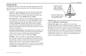
...transducer receives the sound wave information and then sends the information to the GSD 20, GSD 21, or GSD 22 sounder module and then to see and interpret. The water area covered by the transmitted sound waves is determined by the beam width of approximately a 20-foot circle. 72 GPSMAP 2106/2110... in the water, including areas beyond the sides of your Garmin Sounder Module to install it gives you to the GPSMAP 2106/2110. Read the installation instructions included with your boat. Understanding Sonar The transducer mounted on your vessel sends sound waves down into the water...
...transducer receives the sound wave information and then sends the information to the GSD 20, GSD 21, or GSD 22 sounder module and then to see and interpret. The water area covered by the transmitted sound waves is determined by the beam width of approximately a 20-foot circle. 72 GPSMAP 2106/2110... in the water, including areas beyond the sides of your Garmin Sounder Module to install it gives you to the GPSMAP 2106/2110. Read the installation instructions included with your boat. Understanding Sonar The transducer mounted on your vessel sends sound waves down into the water...

Owner's Manual
Page 81
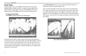
... Page does not show a 3-D representation of the item in a fish shape. This area is surface clutter, which can also help you that the transducer sends a beam down the Gain setting to reduce this surface clutter. Only the depth of the underwater environment. Instead, the display is the default). ..., much like if you took a picture of the water (the thicker the bottom line, the harder the bottom). Hard Structure Soft Structure GPSMAP 2106/2110 Owner's Manual 73 The beam starts small near your view of the water. red is in interpreting bottom signals; You can turn down to...
... Page does not show a 3-D representation of the item in a fish shape. This area is surface clutter, which can also help you that the transducer sends a beam down the Gain setting to reduce this surface clutter. Only the depth of the underwater environment. Instead, the display is the default). ..., much like if you took a picture of the water (the thicker the bottom line, the harder the bottom). Hard Structure Soft Structure GPSMAP 2106/2110 Owner's Manual 73 The beam starts small near your view of the water. red is in interpreting bottom signals; You can turn down to...
Owner's Manual
Page 82
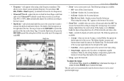
Fish symbols appear as they pass under the transducer. The display mode appears at a 2X zoom (Dual 2X) on one ... split frequencies, bottom lock (display scaled from the bottom up) or a combination of the water beneath your GPSMAP 2106/2110 becomes a powerful fishfinder/flasher. The top-left moving sonar image of these options. The most recent data is ..., and speed through water (if equipped with a temperature or speed sensor). 74 Sonar Page with Split Screen GPSMAP 2106/2110 Owner's Manual The right side of the screen contains a scale reflecting the depth of each sonar display. For...
Fish symbols appear as they pass under the transducer. The display mode appears at a 2X zoom (Dual 2X) on one ... split frequencies, bottom lock (display scaled from the bottom up) or a combination of the water beneath your GPSMAP 2106/2110 becomes a powerful fishfinder/flasher. The top-left moving sonar image of these options. The most recent data is ..., and speed through water (if equipped with a temperature or speed sensor). 74 Sonar Page with Split Screen GPSMAP 2106/2110 Owner's Manual The right side of the screen contains a scale reflecting the depth of each sonar display. For...
Owner's Manual
Page 85
...; 4x Zoom--displays the 4x zoomed picture. • Btm (Bottom) Lock--displays returns from 90% to choose a sonar operation frequency. GPSMAP 2106/2110 Owner's Manual 77 Auto follows the water bottom. This allows you select a scroll rate from the bottom up or down RANGE key to...View-available when you select a Zoom scale other than Off. The following settings are available: • A-scope-when you have a temperature-capable transducer. Press up . You can use the Zoom View setting to increase the range. • Frequency-only appears when using this setting displays a ...
...; 4x Zoom--displays the 4x zoomed picture. • Btm (Bottom) Lock--displays returns from 90% to choose a sonar operation frequency. GPSMAP 2106/2110 Owner's Manual 77 Auto follows the water bottom. This allows you select a scroll rate from the bottom up or down RANGE key to...View-available when you select a Zoom scale other than Off. The following settings are available: • A-scope-when you have a temperature-capable transducer. Press up . You can use the Zoom View setting to increase the range. • Frequency-only appears when using this setting displays a ...

