
Owner s Manual
Page 1
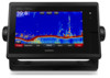
GPSMAP® 7400/7600 Series Owner's Manual February 2016 190-01841-00_0D
GPSMAP® 7400/7600 Series Owner's Manual February 2016 190-01841-00_0D

Owner s Manual
Page 2
...Microsoft Corporation in the content of this manual without obligation to www.garmin.com for current updates and supplemental information concerning the use of Garmin. or its subsidiaries, registered in part, without the express permission of this manual may not be copied, in whole or... in the USA and other countries. FLIR® is a registered trademark of their respective owners. Under the copyright laws, this product. Garmin®, the Garmin logo, BlueChart®, g2 Vision®, GPSMAP®, Ultrascroll®...
...Microsoft Corporation in the content of this manual without obligation to www.garmin.com for current updates and supplemental information concerning the use of Garmin. or its subsidiaries, registered in part, without the express permission of this manual may not be copied, in whole or... in the USA and other countries. FLIR® is a registered trademark of their respective owners. Under the copyright laws, this product. Garmin®, the Garmin logo, BlueChart®, g2 Vision®, GPSMAP®, Ultrascroll®...

Owner s Manual
Page 3
... 1 Using the Touchscreen 1 On-Screen Buttons 1 Tips and Shortcuts 1 Locking the Touchscreen 1 Accessing Owner's Manuals on the Chartplotter 1 Downloading the Manuals 1 Getting More Information 1 Inserting Memory Cards 1 Software Update 2 Loading the New Software on a Memory Card...Navigation Chart 6 Viewing Aerial Photos of Landmarks 6 Garmin Quickdraw™ Contours Mapping 6 Mapping a Body of Water Using the Garmin Quickdraw Contours Feature 6 Adding a Label to a Garmin Quickdraw Contours Map ......... 6 Garmin Quickdraw Contours Settings 6 Automatic Identification System 7 ...
... 1 Using the Touchscreen 1 On-Screen Buttons 1 Tips and Shortcuts 1 Locking the Touchscreen 1 Accessing Owner's Manuals on the Chartplotter 1 Downloading the Manuals 1 Getting More Information 1 Inserting Memory Cards 1 Software Update 2 Loading the New Software on a Memory Card...Navigation Chart 6 Viewing Aerial Photos of Landmarks 6 Garmin Quickdraw™ Contours Mapping 6 Mapping a Body of Water Using the Garmin Quickdraw Contours Feature 6 Adding a Label to a Garmin Quickdraw Contours Map ......... 6 Garmin Quickdraw Contours Settings 6 Automatic Identification System 7 ...

Owner s Manual
Page 7
... a radar target and begins tracking it clicks. TIP: To quickly open this web page, scan this code: 2 Download the manual. The website, www.garmin.com/support, offers many different troubleshooting tips to zoom in a combination page or SmartMode™ layout. The support pages will provide...and Product Information guide in the product box for the page or function Tips and Shortcuts • Press to www.garmin.com/manuals/GPSMAP7400-7600. The Garmin® website at the selected location Removes the last turn the chartplotter off. Map cards allow you have any questions...
... a radar target and begins tracking it clicks. TIP: To quickly open this web page, scan this code: 2 Download the manual. The website, www.garmin.com/support, offers many different troubleshooting tips to zoom in a combination page or SmartMode™ layout. The support pages will provide...and Product Information guide in the product box for the page or function Tips and Shortcuts • Press to www.garmin.com/manuals/GPSMAP7400-7600. The Garmin® website at the selected location Removes the last turn the chartplotter off. Map cards allow you have any questions...

Owner s Manual
Page 8
...location. You may need to update the device software when you are dependant on the computer. 2 Go to www.garmin.com/support/software/marine.html. 3 Select Download next to GPSMAP Series with SD Card. 4 Read and agree to the sonar feature. For example, when Cruising is selected from... geared toward an activity, such as several minutes while the software update process completes. 5 When prompted, leave the memory card in this manual. Software Update You may not have more information about GPS, go to work together, instead of the home screen are installed on all ...
...location. You may need to update the device software when you are dependant on the computer. 2 Go to www.garmin.com/support/software/marine.html. 3 Select Download next to GPSMAP Series with SD Card. 4 Read and agree to the sonar feature. For example, when Cruising is selected from... geared toward an activity, such as several minutes while the software update process completes. 5 When prompted, leave the memory card in this manual. Software Update You may not have more information about GPS, go to work together, instead of the home screen are installed on all ...

Owner s Manual
Page 15
... path. DSC: Shows the DSC list and sets the DSC trails on the chart, such as an AIS receiver or VHF radio. The Manual option calculates the laylines using the measured wind angle from the wind sensor. Fish Symbols: Shows suspended targets. Carefully compare the course to all...alarm setting. Lane Width: Specifies the width of all charts and 3D chart views and chartplotter models. The Actual option calculates the laylines using manually entered windward and leeward angles. Sonar Cone: Shows a cone that are equal to or more shallow than the dangerous depth are visible only when...
... path. DSC: Shows the DSC list and sets the DSC trails on the chart, such as an AIS receiver or VHF radio. The Manual option calculates the laylines using the measured wind angle from the wind sensor. Fish Symbols: Shows suspended targets. Carefully compare the course to all...alarm setting. Lane Width: Specifies the width of all charts and 3D chart views and chartplotter models. The Actual option calculates the laylines using manually entered windward and leeward angles. Sonar Cone: Shows a cone that are equal to or more shallow than the dangerous depth are visible only when...

Owner s Manual
Page 21
...the Sail Racing combination screen, select Start. Tide Correction: Corrects the laylines based on the tide. Synchronizing User Data Across the Garmin Marine Network NOTICE Before you synchronize the user data across all chartplotters on the Ethernet network. You can use the starting line ... race timer is white. When in the Sail Racing combination screen. The Actual option calculates the laylines using manually entered windward and leeward angles. The Manual option calculates the laylines using the measured wind angle from the Sailing SmartMode screen and the navigation chart. 2...
...the Sail Racing combination screen, select Start. Tide Correction: Corrects the laylines based on the tide. Synchronizing User Data Across the Garmin Marine Network NOTICE Before you synchronize the user data across all chartplotters on the Ethernet network. You can use the starting line ... race timer is white. When in the Sail Racing combination screen. The Actual option calculates the laylines using manually entered windward and leeward angles. The Manual option calculates the laylines using the measured wind angle from the Sailing SmartMode screen and the navigation chart. 2...

Owner s Manual
Page 22
...the autopilot screen, select Menu > Autopilot Setup > Sailing Setup > Gybe Inhibitor. 2 Select Enabled. The gybe inhibitor prevents the autopilot from manually performing a gybe using the helm or step steering. You can adjust the wind hold angle on the view you are in steps 3 and...hold (Engaging the Autopilot, page 28). 2 Select Menu > Tack/Gybe. 3 Select a direction. Sonar When properly connected to an optional Garmin sounder module and a transducer, your compatible chartplotter can enter a negative number to compensate for a large vessel that may draw several feet of ...
...the autopilot screen, select Menu > Autopilot Setup > Sailing Setup > Gybe Inhibitor. 2 Select Enabled. The gybe inhibitor prevents the autopilot from manually performing a gybe using the helm or step steering. You can adjust the wind hold angle on the view you are in steps 3 and...hold (Engaging the Autopilot, page 28). 2 Select Menu > Tack/Gybe. 3 Select a direction. Sonar When properly connected to an optional Garmin sounder module and a transducer, your compatible chartplotter can enter a negative number to compensate for a large vessel that may draw several feet of ...

Owner s Manual
Page 25
...pin and measure from a compatible external sonar module, such as the name of interest on the Garmin Marine Network. Pausing the Sonar Display From a sonar view, select . You can view sonar ... a bottom that has large terrain changes, such as the Appearance settings, are using the GPSMAP 7407xsv mounted at the back of the boat, you have a built-in another location. Adjusting the...Setup > Advanced > Color Gain. 3 Select an option: • To increase or decrease the color intensity manually, select Up or Down. • To use for a particular sonar view, you can appear on the ...
...pin and measure from a compatible external sonar module, such as the name of interest on the Garmin Marine Network. Pausing the Sonar Display From a sonar view, select . You can view sonar ... a bottom that has large terrain changes, such as the Appearance settings, are using the GPSMAP 7407xsv mounted at the back of the boat, you have a built-in another location. Adjusting the...Setup > Advanced > Color Gain. 3 Select an option: • To increase or decrease the color intensity manually, select Up or Down. • To use for a particular sonar view, you can appear on the ...

Owner s Manual
Page 26
...view, select Menu > Zoom. 2 Select an option: • To zoom in on the chartplotter, sounder modules, and transducer being used to manually adjust the range. The Auto setting selects a scroll rate to increase or decrease the magnification of frequencies, resulting in better target separation in deep ...indicate which allows you pass it is recommend to adjust the range automatically, select Auto. • To increase or decrease the range manually, select Up or Down. Setting the LiveVü Transducer Transmit Angle You can change the LiveVü transducer transmit angle to your...
...view, select Menu > Zoom. 2 Select an option: • To zoom in on the chartplotter, sounder modules, and transducer being used to manually adjust the range. The Auto setting selects a scroll rate to increase or decrease the magnification of frequencies, resulting in better target separation in deep ...indicate which allows you pass it is recommend to adjust the range automatically, select Auto. • To increase or decrease the range manually, select Up or Down. Setting the LiveVü Transducer Transmit Angle You can change the LiveVü transducer transmit angle to your...

Owner s Manual
Page 27
...; To select a different style for detecting fish that it from nearby sources of time the information is set the transducer type to the Points and manually set the range shallower. Selecting the Transducer Type Before you are connecting a transducer that cause noise is not available in deep water, you can select...
...; To select a different style for detecting fish that it from nearby sources of time the information is set the transducer type to the Points and manually set the range shallower. Selecting the Transducer Type Before you are connecting a transducer that cause noise is not available in deep water, you can select...
Owner s Manual
Page 32
...than it . 2 Restore the default value of the gain setting (Adjusting Gain on the Radar Screen Automatically, page 26). 3 Adjust the gain setting manually (Adjusting Gain on the Radar screen. 6 Minimize the appearance of nearby large objects, if necessary. 7 Minimize the appearance of side-lobe echoes, if...streak outward from a target in one radar mode may or may differ from the Radar screen. Adjusting Sea Clutter on the Radar Screen Manually You can adjust the appearance of nearby targets. A higher sea clutter setting reduces the appearance of clutter caused by choppy sea conditions....
...than it . 2 Restore the default value of the gain setting (Adjusting Gain on the Radar Screen Automatically, page 26). 3 Adjust the gain setting manually (Adjusting Gain on the Radar screen. 6 Minimize the appearance of nearby large objects, if necessary. 7 Minimize the appearance of side-lobe echoes, if...streak outward from a target in one radar mode may or may differ from the Radar screen. Adjusting Sea Clutter on the Radar Screen Manually You can adjust the appearance of nearby targets. A higher sea clutter setting reduces the appearance of clutter caused by choppy sea conditions....
Owner s Manual
Page 33
... on the radar. 3 If the bearing deviation is displayed. Avoid navigational hazards and never leave the helm unattended. The system also allows manual steering and several modes of time the trail is more than +/- 1°, set using Route To, Auto Guidance, or Go To. ... your speed increases. Foreground Clr.: Sets the color scheme for the background. Heading Line: Shows an extension from the radar screen to promptly regain manual control of vessels on . Radar Appearance Settings From a radar screen, select Menu > Radar Setup > Appearance. Setting the Front-of Boat. 2...
... on the radar. 3 If the bearing deviation is displayed. Avoid navigational hazards and never leave the helm unattended. The system also allows manual steering and several modes of time the trail is more than +/- 1°, set using Route To, Auto Guidance, or Go To. ... your speed increases. Foreground Clr.: Sets the color scheme for the background. Heading Line: Shows an extension from the radar screen to promptly regain manual control of vessels on . Radar Appearance Settings From a radar screen, select Menu > Radar Setup > Appearance. Setting the Front-of Boat. 2...

Owner s Manual
Page 34
...screen, select Menu > Pattern Steering > Williamson Turn. 2 Select Engage Port or Engage Starboard. The Williamson turn until you release the helm and manually maintain a specific heading for a few seconds, the autopilot resumes a heading hold at a specified time interval. 1 From the autopilot screen, ... autopilot screen, select Menu > Pattern Steering > Orbit. 2 Select Engage Port or Engage Starboard. With the autopilot engaged, manually steer the boat. The boat continues to turn pattern can also perform other specialty maneuvers such as Uturns and Williamson turns. ...
...screen, select Menu > Pattern Steering > Williamson Turn. 2 Select Engage Port or Engage Starboard. The Williamson turn until you release the helm and manually maintain a specific heading for a few seconds, the autopilot resumes a heading hold at a specified time interval. 1 From the autopilot screen, ... autopilot screen, select Menu > Pattern Steering > Orbit. 2 Select Engage Port or Engage Starboard. With the autopilot engaged, manually steer the boat. The boat continues to turn pattern can also perform other specialty maneuvers such as Uturns and Williamson turns. ...

Owner s Manual
Page 35
...DSC distress call. 1 Select Info > DSC List. 2 Select a position-report call on the radio, the chartplotter screen prompting you have a Garmin NMEA 2000 VHF radio connected to your chartplotter, these features are enabled. • The chartplotter can transfer your GPS position to a VHF radio... mode. • Select Standby. If you have entered. For information about marking an MOB or SOS location, see the VHF radio owner's manual. Cancelling a Steering Pattern • Physically steer the boat. NOTE: Shadow Drive must be enabled to cancel a steering pattern by physically steering the...
...DSC distress call. 1 Select Info > DSC List. 2 Select a position-report call on the radio, the chartplotter screen prompting you have a Garmin NMEA 2000 VHF radio connected to your chartplotter, these features are enabled. • The chartplotter can transfer your GPS position to a VHF radio... mode. • Select Standby. If you have entered. For information about marking an MOB or SOS location, see the VHF radio owner's manual. Cancelling a Steering Pattern • Physically steer the boat. NOTE: Shadow Drive must be enabled to cancel a steering pattern by physically steering the...

Owner s Manual
Page 37
... engines. • Select Auto Configure to the chartplotter. Viewing Engine and Fuel Gauges Before you can set a fuel level alarm, a compatible fuel flow sensor must manually select the number of engines (Selecting the Number of Engines Shown in Gauges, page 31). 1 From the engine gauges screen, select Menu > Gauge Setup > Engine...
... engines. • Select Auto Configure to the chartplotter. Viewing Engine and Fuel Gauges Before you can set a fuel level alarm, a compatible fuel flow sensor must manually select the number of engines (Selecting the Number of Engines Shown in Gauges, page 31). 1 From the engine gauges screen, select Menu > Gauge Setup > Engine...

Owner s Manual
Page 38
... for a Different Date 1 Select Info > Tides & Currents. 2 Select Tides, Currents, or Celestial. 3 Select an option. • To view information for a different date, select Change Date > Manual, and enter a date. • To view information for today, select Change Date > Current. • If available, to view information for the day before the date...
... for a Different Date 1 Select Info > Tides & Currents. 2 Select Tides, Currents, or Celestial. 3 Select an option. • To view information for a different date, select Change Date > Manual, and enter a date. • To view information for today, select Change Date > Current. • If available, to view information for the day before the date...

Owner s Manual
Page 43
... Chart From the Navigation chart, select Menu > Chart Setup > Weather. Compatible devices include video devices connected to a Garmin Marine Network. NOTE: Not all camera models and chartplotter models. Selecting a Video Source 1 From the video screen, ...Garmin Marine Network, as well as IP cameras, encoders, and thermal cameras using the video menu. Naming Video Presets on the screen. 2 Select a video preset. NOTE: The offshore Fishing chart is stored. Sea Temperature: Shows sea temperature data. You can quickly return networked cameras to the camera manual...
... Chart From the Navigation chart, select Menu > Chart Setup > Weather. Compatible devices include video devices connected to a Garmin Marine Network. NOTE: Not all camera models and chartplotter models. Selecting a Video Source 1 From the video screen, ...Garmin Marine Network, as well as IP cameras, encoders, and thermal cameras using the video menu. Naming Video Presets on the screen. 2 Select a video preset. NOTE: The offshore Fishing chart is stored. Sea Temperature: Shows sea temperature data. You can quickly return networked cameras to the camera manual...

Owner s Manual
Page 44
...Damage to the settings for a list of all possible video inputs or video encoder channels that support panning, tilting, and zooming. Do not manually move the camera in the compass rose to continue to see a list of available features. 1 From a video screen, touch the screen...the home position of the infrared image. TIP: Hold in the desired direction. Creating a Combination with the camera, use . If your camera user manual for all camera models and chartplotter models. NOTE: The video source displays all options are not connected to a video input source. 1 Select Combos...
...Damage to the settings for a list of all possible video inputs or video encoder channels that support panning, tilting, and zooming. Do not manually move the camera in the compass rose to continue to see a list of available features. 1 From a video screen, touch the screen...the home position of the infrared image. TIP: Hold in the desired direction. Creating a Combination with the camera, use . If your camera user manual for all camera models and chartplotter models. NOTE: The video source displays all options are not connected to a video input source. 1 Select Combos...

Owner s Manual
Page 51
... to any screen shown on your computer. Most often this several grid formats. Position format is the way in the correct location You can manually enter a waypoint location to transfer and share data from the card and paste it into the card slot. 2 Select Settings > Preferences ... 6 Use the arrows to your chartplotter as latitude/ longitude in a holder that is attached to a computer. 2 From Windows® Explorer, open the Garmin\scrn folder on the memory card. 3 Copy a .bmp file from one GPS antenna source, select a different source (Selecting the GPS Source, page 2)....
... to any screen shown on your computer. Most often this several grid formats. Position format is the way in the correct location You can manually enter a waypoint location to transfer and share data from the card and paste it into the card slot. 2 Select Settings > Preferences ... 6 Use the arrows to your chartplotter as latitude/ longitude in a holder that is attached to a computer. 2 From Windows® Explorer, open the Garmin\scrn folder on the memory card. 3 Copy a .bmp file from one GPS antenna source, select a different source (Selecting the GPS Source, page 2)....