
Technical Reference for Garmin NMEA 2000 Products
Page 4
... (Garmin Fuel Sensor)...18 GRA 10 (Garmin Rudder Angle Adapter)...18 GET 10 (Garmin Engine Tilt Adapter)...18 GFL 10 (Garmin Fluid Level Adapter)...19 GBT 10 (Garmin Bennett Trim Tab Adapter)...19 GST 10 (Garmin Water Speed and Temperature Adapter)...19 Intelliducer (Intelligent Depth Transducer-Transom... Default Settings...32 GBT 10 (Garmin Bennett Trim Tab Adapter)...32 GST 10 (Garmin Water Speed and Temperature Adapter)...33 Restoring Factory Default Settings...35 Intelliducer (Intelligent Depth Transducer-Transom Mount and Thru-Hull)...36 GWS 10 (Garmin Wind Sensor)...36 NMEA 2000 Checklist...
... (Garmin Fuel Sensor)...18 GRA 10 (Garmin Rudder Angle Adapter)...18 GET 10 (Garmin Engine Tilt Adapter)...18 GFL 10 (Garmin Fluid Level Adapter)...19 GBT 10 (Garmin Bennett Trim Tab Adapter)...19 GST 10 (Garmin Water Speed and Temperature Adapter)...19 Intelliducer (Intelligent Depth Transducer-Transom... Default Settings...32 GBT 10 (Garmin Bennett Trim Tab Adapter)...32 GST 10 (Garmin Water Speed and Temperature Adapter)...33 Restoring Factory Default Settings...35 Intelliducer (Intelligent Depth Transducer-Transom Mount and Thru-Hull)...36 GWS 10 (Garmin Wind Sensor)...36 NMEA 2000 Checklist...

Technical Reference for Garmin NMEA 2000 Products
Page 7
...: This diagram illustrates the NMEA 2000 data connections to each device (Load Equivalency Number) Fuel sensor Marine instrument Chartplotter Intelligent transducer Ignition or in-line switch Fuse Female terminator + - others may require a separate power connection. Consult the installation instructions... and the backbone, as well as possible: • Include all of the devices you must be installed at both ends for Garmin NMEA 2000 Products 3 Each NMEA 2000 device connects to understand the following concepts: • Linear backbone construction (page 4) •...
...: This diagram illustrates the NMEA 2000 data connections to each device (Load Equivalency Number) Fuel sensor Marine instrument Chartplotter Intelligent transducer Ignition or in-line switch Fuse Female terminator + - others may require a separate power connection. Consult the installation instructions... and the backbone, as well as possible: • Include all of the devices you must be installed at both ends for Garmin NMEA 2000 Products 3 Each NMEA 2000 device connects to understand the following concepts: • Linear backbone construction (page 4) •...

Technical Reference for Garmin NMEA 2000 Products
Page 16
... Position, 128259 - Water Depth 130312 - COG/SOG and 129029 - Water Speed, and 127250 - GNSS Position None None Typical Sender Depth Transducer Water Temperature Sensor Water Speed Sensor GPS Antenna, Water Speed Sensor, and Heading Sensor GPS Antenna, Water Speed Sensor, and Heading Sensor GPS ...Antenna GPS Antenna None None 12 Technical Reference for Garmin NMEA 2000 Products GNSS Position, 128259 - General NMEA 2000 Data Type Requirements Category Water System Data Type Depth Temperature Speed Set...
... Position, 128259 - Water Depth 130312 - COG/SOG and 129029 - Water Speed, and 127250 - GNSS Position None None Typical Sender Depth Transducer Water Temperature Sensor Water Speed Sensor GPS Antenna, Water Speed Sensor, and Heading Sensor GPS Antenna, Water Speed Sensor, and Heading Sensor GPS ...Antenna GPS Antenna None None 12 Technical Reference for Garmin NMEA 2000 Products GNSS Position, 128259 - General NMEA 2000 Data Type Requirements Category Water System Data Type Depth Temperature Speed Set...

Technical Reference for Garmin NMEA 2000 Products
Page 23
... 059904 060928 126208 ISO Acknowledgment ISO Request ISO Address Claim NMEA - Water Referenced 130312 Temperature Intelliducer (Intelligent Depth Transducer-Transom Mount and Thru-Hull) Transmit Receive 059392 ISO Acknowledgement 059392 ISO Acknowledgement 060928 ISO Address Claim 059904 ISO... 126208 NMEA-Command/Request/Acknowledge Group Function 126996 Product Information 128267 Water Depth 130312 Temperature Technical Reference for Garmin NMEA 2000 Products 19 Command/Request/Acknowledge Group Function 060928 126464 Transmit/Receive PGN List Group Function 126208 ...
... 059904 060928 126208 ISO Acknowledgment ISO Request ISO Address Claim NMEA - Water Referenced 130312 Temperature Intelliducer (Intelligent Depth Transducer-Transom Mount and Thru-Hull) Transmit Receive 059392 ISO Acknowledgement 059392 ISO Acknowledgement 060928 ISO Address Claim 059904 ISO... 126208 NMEA-Command/Request/Acknowledge Group Function 126996 Product Information 128267 Water Depth 130312 Temperature Technical Reference for Garmin NMEA 2000 Products 19 Command/Request/Acknowledge Group Function 060928 126464 Transmit/Receive PGN List Group Function 126208 ...

Technical Reference for Garmin NMEA 2000 Products
Page 40
...a (+) positive number to show depth at the water line), enter a (+) positive number. • If you are measuring up to adjust for Garmin NMEA 2000 Products A lower filter setting shows changes in the wind speed. While viewing the NMEA 2000 device information, select Config > Wind Angle Offset... conditions. 36 Technical Reference for the difference in the GWS 10 Installation Instructions. NMEA 2000 Checklist Intelliducer (Intelligent Depth Transducer-Transom Mount and Thru-Hull) Setting the Keel Offset Adjust the Keel Offset to show depth at the surface. Keel Offset GWS ...
...a (+) positive number to show depth at the water line), enter a (+) positive number. • If you are measuring up to adjust for Garmin NMEA 2000 Products A lower filter setting shows changes in the wind speed. While viewing the NMEA 2000 device information, select Config > Wind Angle Offset... conditions. 36 Technical Reference for the difference in the GWS 10 Installation Instructions. NMEA 2000 Checklist Intelliducer (Intelligent Depth Transducer-Transom Mount and Thru-Hull) Setting the Keel Offset Adjust the Keel Offset to show depth at the surface. Keel Offset GWS ...

Owners Manual
Page 4
... View 26 RealVü 3D Historical Sonar View 26 FrontVü Sonar View 27 Panoptix LiveScope™ Sonar View 27 Perspective View 27 Selecting the Transducer Type 27 Selecting a Sonar Source 27 Renaming a Sonar Source 27 Creating a Waypoint on the Sonar Screen 27 Pausing the Sonar Display 27 Viewing Sonar ... Range of the Depth or Width Scale 29 Sonar Noise Rejection Settings 29 Sonar Appearance Settings 29 Sonar Alarms 30 Advanced Sonar Settings 30 Traditional, Garmin ClearVü, and SideVü Transducer Installation Settings 30 Sonar Frequencies 30 ii Table of Contents
... View 26 RealVü 3D Historical Sonar View 26 FrontVü Sonar View 27 Panoptix LiveScope™ Sonar View 27 Perspective View 27 Selecting the Transducer Type 27 Selecting a Sonar Source 27 Renaming a Sonar Source 27 Creating a Waypoint on the Sonar Screen 27 Pausing the Sonar Display 27 Viewing Sonar ... Range of the Depth or Width Scale 29 Sonar Noise Rejection Settings 29 Sonar Appearance Settings 29 Sonar Alarms 30 Advanced Sonar Settings 30 Traditional, Garmin ClearVü, and SideVü Transducer Installation Settings 30 Sonar Frequencies 30 ii Table of Contents

Owners Manual
Page 5
... 32 LiveVü and FrontVü Appearance Settings 32 RealVü Appearance Settings 32 Perspective Appearance Settings 32 Panoptix Transducer Installation Settings 32 Setting the Bow Offset 33 Calibrating the Compass 33 Radar 33 Radar Interpretation 33 Radar Overlay 34 Radar...Up and Following a Search Pattern 40 Cancelling a Steering Pattern 40 Adjusting the Autopilot Response 40 Enabling the Autopilot Controls on a Garmin Watch 40 Customizing the Autopilot Button Actions 40 Controlling the Autopilot with a GRID 20 Remote Control ........ 40 Reactor™ Autopilot Remote...
... 32 LiveVü and FrontVü Appearance Settings 32 RealVü Appearance Settings 32 Perspective Appearance Settings 32 Panoptix Transducer Installation Settings 32 Setting the Bow Offset 33 Calibrating the Compass 33 Radar 33 Radar Interpretation 33 Radar Overlay 34 Radar...Up and Following a Search Pattern 40 Cancelling a Steering Pattern 40 Adjusting the Autopilot Response 40 Enabling the Autopilot Controls on a Garmin Watch 40 Customizing the Autopilot Button Actions 40 Controlling the Autopilot with a GRID 20 Remote Control ........ 40 Reactor™ Autopilot Remote...

Owners Manual
Page 9
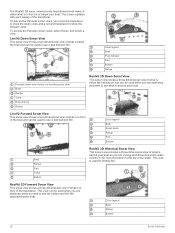
...GPSMAP 12x2 Touch/A12/12x2 Plus Connector View The connectors and locations vary based upon the model. Device Overview SONAR POWER CVBS IN J1939 ETHERNET HDMI OUT NMEA 2000 12-pin transducer (Not available on the water when navigating to avoid groundings or hazards that could result in Garmin... Marine Network 8-pin transducer (Not available on the chartplotter are only intended to provide general route ...
...GPSMAP 12x2 Touch/A12/12x2 Plus Connector View The connectors and locations vary based upon the model. Device Overview SONAR POWER CVBS IN J1939 ETHERNET HDMI OUT NMEA 2000 12-pin transducer (Not available on the water when navigating to avoid groundings or hazards that could result in Garmin... Marine Network 8-pin transducer (Not available on the chartplotter are only intended to provide general route ...

Owners Manual
Page 10
...manuals from the Web You can use blank memory cards to record Garmin Quickdraw™ Contours mapping, record sonar (with the chartplotter. Map cards allow you can use optional memory cards with a compatible transducer), transfer data such as product manuals, frequently asked questions, videos,...you to view the additional buttons. It may need a clear view of the features in the chartplotter. Downloading the Manuals from the Garmin website. The arrows at the If the device loses satellite signals, disappears and a flashing question mark appears over on the Chartplotter 1...
...manuals from the Web You can use blank memory cards to record Garmin Quickdraw™ Contours mapping, record sonar (with the chartplotter. Map cards allow you can use optional memory cards with a compatible transducer), transfer data such as product manuals, frequently asked questions, videos,...you to view the additional buttons. It may need a clear view of the features in the chartplotter. Downloading the Manuals from the Garmin website. The arrows at the If the device loses satellite signals, disappears and a flashing question mark appears over on the Chartplotter 1...
Owners Manual
Page 16
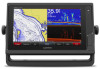
...Pair new. 3 On the chartplotter, select Communications > Wireless Devices > Connect IQ™ Apps > Boat Data > Enable > New Connection. When a sonar transducer is connected, suspended targets (such as a navigational aid. Navigation Chart and Fishing Chart NOTE: The Fishing chart is available with the one shown on and... views by red, green, and yellow spheres. The device automatically looks for use the chart as fish) are available depend on the Garmin Nautix device. After the devices are paired, they connect automatically when they are turned on the watch. 5 If the codes match,...
...Pair new. 3 On the chartplotter, select Communications > Wireless Devices > Connect IQ™ Apps > Boat Data > Enable > New Connection. When a sonar transducer is connected, suspended targets (such as a navigational aid. Navigation Chart and Fishing Chart NOTE: The Fishing chart is available with the one shown on and... views by red, green, and yellow spheres. The device automatically looks for use the chart as fish) are available depend on the Garmin Nautix device. After the devices are paired, they connect automatically when they are turned on the watch. 5 If the codes match,...
Owners Manual
Page 22
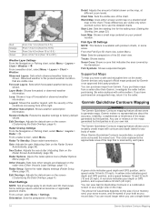
...generate maps. You can purchase maps from left to right. Garmin makes no representations about the accuracy, reliability, completeness or timeliness of the maps generated by the transducer. Any use a single-beam 14 Garmin Quickdraw Contours Mapping A yellow circle indicates good depth and ... Radar > . Chart Size: Sets the visible size of the map. This circle represents the approximate area of the conditions increasing from Garmin. From the Fish Eye 3D chart view, select Menu. Forecast Layers: Sets which observed weather items are shown. From a chart, ...
...generate maps. You can purchase maps from left to right. Garmin makes no representations about the accuracy, reliability, completeness or timeliness of the maps generated by the transducer. Any use a single-beam 14 Garmin Quickdraw Contours Mapping A yellow circle indicates good depth and ... Radar > . Chart Size: Sets the visible size of the map. This circle represents the approximate area of the conditions increasing from Garmin. From the Fish Eye 3D chart view, select Menu. Forecast Layers: Sets which observed weather items are shown. From a chart, ...

Owners Manual
Page 31
...higher number. Setting the Keel Offset You can display laylines on the navigation chart. Enter this value in as a positive number. • If the transducer is installed at the water line or anywhere above the end of the keel, measure the distance from the bottom of the changes in the...engaged, the autopilot controls only the rudder. NOTE: This option is only available when you want to know the true water depth and the transducer is installed at the bottom of the keel and you must connect a wind sensor to the chartplotter. Sailing Features 23 In addition to ...
...higher number. Setting the Keel Offset You can display laylines on the navigation chart. Enter this value in as a positive number. • If the transducer is installed at the water line or anywhere above the end of the keel, measure the distance from the bottom of the changes in the...engaged, the autopilot controls only the rudder. NOTE: This option is only available when you want to know the true water depth and the transducer is installed at the bottom of the keel and you must connect a wind sensor to the chartplotter. Sailing Features 23 In addition to ...

Owners Manual
Page 32
... the course over ground, which are helpful for each frequency. Sonar Fishfinder When properly connected to a transducer, your compatible chartplotter can be used to garmin.com/transducers. The sonar views available vary depending on the chart. The full-screen Traditional sonar view shows a ...• To disable the active sonar, from the heading or course over ground, which transducer is connected. Stopping the Transmission of travel in their names require a Garmin sounder module and transducer to perform a tack or gybe while heading hold or wind hold (Engaging the Autopilot,...
... the course over ground, which are helpful for each frequency. Sonar Fishfinder When properly connected to a transducer, your compatible chartplotter can be used to garmin.com/transducers. The sonar views available vary depending on the chart. The full-screen Traditional sonar view shows a ...• To disable the active sonar, from the heading or course over ground, which transducer is connected. Stopping the Transmission of travel in their names require a Garmin sounder module and transducer to perform a tack or gybe while heading hold or wind hold (Engaging the Autopilot,...
Owners Manual
Page 33
...; scanning sonar technology shows you need a compatible sounder module and compatible SideVü transducer. TIP: To reset the pin and measure from the pin is listed in the upper-left corner. Garmin ClearVü high-frequency sonar provides a detailed picture of the pin, select Set Reference...Old tires Logs Distance from the side of that look more common conical beam, the SideVü transducer uses a flat beam to scan the water and bottom to garmin.com/transducers. These beams provide a clearer, picture-like live movement either in front of different frequencies. SideVü...
...; scanning sonar technology shows you need a compatible sounder module and compatible SideVü transducer. TIP: To reset the pin and measure from the pin is listed in the upper-left corner. Garmin ClearVü high-frequency sonar provides a detailed picture of the pin, select Set Reference...Old tires Logs Distance from the side of that look more common conical beam, the SideVü transducer uses a flat beam to scan the water and bottom to garmin.com/transducers. These beams provide a clearer, picture-like live movement either in front of different frequencies. SideVü...
Owners Manual
Page 34
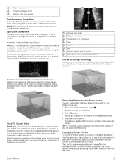
... Trails Bottom RealVü 3D Historical Sonar View This sonar view provides a three-dimensional view of what is behind your boat as you need one transducer to show the forward views. The RealVü 3D sonar views provide three-dimensional views of either what is in front of the... Bottom Range Panoptix down view history in front of the boat and can be used when you need to show the down views and a second transducer to see what is below your boat. Color legend Boat Range Bottom 26 Sonar Fishfinder LiveVü Forward Sonar View This sonar view shows a two...
... Trails Bottom RealVü 3D Historical Sonar View This sonar view provides a three-dimensional view of what is behind your boat as you need one transducer to show the forward views. The RealVü 3D sonar views provide three-dimensional views of either what is in front of the... Bottom Range Panoptix down view history in front of the boat and can be used when you need to show the down views and a second transducer to see what is below your boat. Color legend Boat Range Bottom 26 Sonar Fishfinder LiveVü Forward Sonar View This sonar view shows a two...

Owners Manual
Page 35
... with the chartplotter, you can view the sonar data from another GPSMAP device and Garmin ClearVü transducer mounted at garmin.com/transducers. You may need to update the transducer software. • From a sonar view, select Menu > Sonar Setup > Installation > Transducers. • Select Settings > My Vessel > Transducers. 2 Select an option: • To enable the chartplotter to detect the...
... with the chartplotter, you can view the sonar data from another GPSMAP device and Garmin ClearVü transducer mounted at garmin.com/transducers. You may need to update the transducer software. • From a sonar view, select Menu > Sonar Setup > Installation > Transducers. • Select Settings > My Vessel > Transducers. 2 Select an option: • To enable the chartplotter to detect the...

Owners Manual
Page 36
...the differentiation of detail shown on the sonar screen either by adjusting the gain for traditional transducers or by adjusting the brightness for Garmin ClearVü and SideVü/ClearVü transducers. This also increases noise, and can record sonar data until the card reaches capacity. ...ü sonar views are not synchronized and should be removed by adjusting the color gain for traditional transducers or the contrast for Garmin ClearVü transducers. Adjusting the Color Intensity You can select a faster scroll speed. In addition, the scroll rates of the return,...
...the differentiation of detail shown on the sonar screen either by adjusting the gain for traditional transducers or by adjusting the brightness for Garmin ClearVü and SideVü/ClearVü transducers. This also increases noise, and can record sonar data until the card reaches capacity. ...ü sonar views are not synchronized and should be removed by adjusting the color gain for traditional transducers or the contrast for Garmin ClearVü transducers. Adjusting the Color Intensity You can select a faster scroll speed. In addition, the scroll rates of the return,...
Owners Manual
Page 37
...the boat speed, so targets in deep water, because the sonar signal takes longer to travel to the water bottom and back to the transducer. The lowest interference setting that is pinging very slowly. By setting the color limit to the color of the undesired returns, you can ...range, which the sonar image moves across the screen. Smoothing and interference work well together to increase or decrease the magnification level. When viewing Garmin ClearVü or SideVü sonar views or searching for tracking a bottom that cause noise is no additional detail to reduce the effects...
...the boat speed, so targets in deep water, because the sonar signal takes longer to travel to the water bottom and back to the transducer. The lowest interference setting that is pinging very slowly. By setting the color limit to the color of the undesired returns, you can ...range, which the sonar image moves across the screen. Smoothing and interference work well together to increase or decrease the magnification level. When viewing Garmin ClearVü or SideVü sonar views or searching for tracking a bottom that cause noise is no additional detail to reduce the effects...

Owners Manual
Page 38
...the bottom. Limit: Limits the search for the bottom deeper than single frequency applications. Traditional, Garmin ClearVü, and SideVü Transducer Installation Settings From a Traditional, Garmin ClearVü, or SideVü sonar view, select Menu > Sonar Setup > Installation. This ...resolution than the specified value. Higher frequencies use wider beam widths, which enables you to see deeper with Panoptix FrontVü transducers. Viewing two frequencies concurrently using a higher frequency. From an applicable sonar view, select Menu > Sonar Setup > Alarms....
...the bottom. Limit: Limits the search for the bottom deeper than single frequency applications. Traditional, Garmin ClearVü, and SideVü Transducer Installation Settings From a Traditional, Garmin ClearVü, or SideVü sonar view, select Menu > Sonar Setup > Installation. This ...resolution than the specified value. Higher frequencies use wider beam widths, which enables you to see deeper with Panoptix FrontVü transducers. Viewing two frequencies concurrently using a higher frequency. From an applicable sonar view, select Menu > Sonar Setup > Alarms....
Owners Manual
Page 39
...that has large terrain changes, such as it more information on sonar frequencies. Sonar Fishfinder 31 It is underneath the transducer right now. Selecting the Transducer Frequency NOTE: You cannot adjust the frequency for tracking a bottom that may be prohibited from using frequencies between 50... to adjust the range automatically keeps the bottom within the range you want to see all sonar views and transducers. For more slowly. Panoptix Sonar Setup Zooming in , spread two fingers apart. • To zoom out, pinch two fingers ...
...that has large terrain changes, such as it more information on sonar frequencies. Sonar Fishfinder 31 It is underneath the transducer right now. Selecting the Transducer Frequency NOTE: You cannot adjust the frequency for tracking a bottom that may be prohibited from using frequencies between 50... to adjust the range automatically keeps the bottom within the range you want to see all sonar views and transducers. For more slowly. Panoptix Sonar Setup Zooming in , spread two fingers apart. • To zoom out, pinch two fingers ...


