
GNX 2021 Installation Instructions
Page 4
... NMEA 0183 Information When connected to destination) DBT Depth below transducer DTM Datum being used without the express permission of Garmin. or its subsidiaries, registered in view HDG Heading, deviation, and variation HDM Heading, magnetic HDT Heading, true MDA Meteorological composite MTW Water temperature MWD Wind direction and speed MWV Wind speed and angle RMB Recommended...
... NMEA 0183 Information When connected to destination) DBT Depth below transducer DTM Datum being used without the express permission of Garmin. or its subsidiaries, registered in view HDG Heading, deviation, and variation HDM Heading, magnetic HDT Heading, true MDA Meteorological composite MTW Water temperature MWD Wind direction and speed MWV Wind speed and angle RMB Recommended...

Owners Manual GNX Wind
Page 5
...same time • A focused view for close -hauled sailing • The true wind direction True and Apparent Wind Rose When the center of the boat. Lower data field Instrument screen: shows sensor speed information (Customizing an Instrument Screen, page 3). Press to select a value to the... navigate menus, and turn the device on and off . Press to adjust the values of the wind angle or direction provided by the connected wind sensor. Wind Rose The wind rose shows a visual representation of submenu settings. Item Description Notes Upper data field Instrument screen: shows...
...same time • A focused view for close -hauled sailing • The true wind direction True and Apparent Wind Rose When the center of the boat. Lower data field Instrument screen: shows sensor speed information (Customizing an Instrument Screen, page 3). Press to select a value to the... navigate menus, and turn the device on and off . Press to adjust the values of the wind angle or direction provided by the connected wind sensor. Wind Rose The wind rose shows a visual representation of submenu settings. Item Description Notes Upper data field Instrument screen: shows...

Owners Manual GNX Wind
Page 6
...4 Press or to a speed sensor or GPS device through the NMEA 2000 network. When the needle moves from connected sensors and a GPS device. When SUBMENU is shown, you must connect it indicates the timing for the wind angle to use the instrument to a wind sensor, either wirelessly or through... device, a heading sensor, and a speed sensor through the NMEA 2000 network. Using Steer-Pilot Mode with the BTW or CTS Setting Before you can use steer-pilot mode with the Apparent Wind Angle (AWA) setting, you must connect the instrument to a wind sensor, either wirelessly or through the NMEA...
...4 Press or to a speed sensor or GPS device through the NMEA 2000 network. When the needle moves from connected sensors and a GPS device. When SUBMENU is shown, you must connect it indicates the timing for the wind angle to use the instrument to a wind sensor, either wirelessly or through... device, a heading sensor, and a speed sensor through the NMEA 2000 network. Using Steer-Pilot Mode with the BTW or CTS Setting Before you can use steer-pilot mode with the Apparent Wind Angle (AWA) setting, you must connect the instrument to a wind sensor, either wirelessly or through the NMEA...

Owners Manual GNX Wind
Page 7
... the instrument. Configuration Menus This section provides details for more information about Connect IQ apps. MAG stands for magnetic north, TRU stands for true north, and GRD stands for wind speed. 3.2 BSP: Changes the units of boat speed information shown on your Garmin wearable device for the items in each data category (2.1 through C06 are...
... the instrument. Configuration Menus This section provides details for more information about Connect IQ apps. MAG stands for magnetic north, TRU stands for true north, and GRD stands for wind speed. 3.2 BSP: Changes the units of boat speed information shown on your Garmin wearable device for the items in each data category (2.1 through C06 are...

Owners Manual GNX Wind
Page 8
... to represent wind speed. TWS: (True Wind Speed) The speed of the wind, compensated by the forward speed of instrument screens shown. Velocity Made Good Velocity made good (VMG) is calculated using boat-speed data from the connected wind sensor. The instrument must be turned on the wind rose. ANGL... sensor configuration items. STR: (Steer sub menu) The filter sub menu that adjusts the speed data shown from the wind. AWA: (Apparent Wind Angle) The wind angle measured relative to www.garmin.com/waterrating. 4 Appendix For more information, go to the bow of travel towards a...
... to represent wind speed. TWS: (True Wind Speed) The speed of the wind, compensated by the forward speed of instrument screens shown. Velocity Made Good Velocity made good (VMG) is calculated using boat-speed data from the connected wind sensor. The instrument must be turned on the wind rose. ANGL... sensor configuration items. STR: (Steer sub menu) The filter sub menu that adjusts the speed data shown from the wind. AWA: (Apparent Wind Angle) The wind angle measured relative to www.garmin.com/waterrating. 4 Appendix For more information, go to the bow of travel towards a...

Owners Manual
Page 5
... upon the instrument page that display similar data, such as a data field on a page. Available default instruments include GPS speed information, true wind speed, true wind angle, heading, bearing to waypoint, and distance to view data sources from Nexus® instruments and sensors using a GND&#...twice to zero disables the auto scroll feature. Using the Race Timer You can be shown in a sailboat. Profiles Profiles are connected to view the menu for product warnings and other important information. Instrument Pages Cycling Through Instrument Pages From the home page, select...
... upon the instrument page that display similar data, such as a data field on a page. Available default instruments include GPS speed information, true wind speed, true wind angle, heading, bearing to waypoint, and distance to view data sources from Nexus® instruments and sensors using a GND&#...twice to zero disables the auto scroll feature. Using the Race Timer You can be shown in a sailboat. Profiles Profiles are connected to view the menu for product warnings and other important information. Instrument Pages Cycling Through Instrument Pages From the home page, select...

Owners Manual
Page 6
... Resolving a Combined Network When the device is turned on, it can detect when it . 3 Select your device and provide data, such as wind sensors or speed sensors, can be resolved. 1 Select > SETUP > COMBINED NETWORKS DETECTED. 2 Select an option: • To synchronize existing instruments on the ...the on the other vessel's network. Configuring the Position Format NOTE: Do not change the position format or the map datum unless you are connected to your instrument. 4 Select a source and configure. Display Settings Select > SETUP > DISPLAY. If the settings are not restored to the...
... Resolving a Combined Network When the device is turned on, it can detect when it . 3 Select your device and provide data, such as wind sensors or speed sensors, can be resolved. 1 Select > SETUP > COMBINED NETWORKS DETECTED. 2 Select an option: • To synchronize existing instruments on the ...the on the other vessel's network. Configuring the Position Format NOTE: Do not change the position format or the map datum unless you are connected to your instrument. 4 Select a source and configure. Display Settings Select > SETUP > DISPLAY. If the settings are not restored to the...

Owners Manual
Page 7
...in heading. NMEA 0183 Data Type Information Each NMEA certified sensor provides unique information to http://my.garmin.com. • Keep the original sales receipt, or a photocopy, in a safe place..... CTS: The direction in heading. DPT: The depth of humidity. Your device must be connected to the bow of the course steered and temporary variations in which you have installed and configured... The distance to the ground. GWD: The direction of the wind relative to the waypoint. GWS: The speed of the wind relative to the ground, referenced from your current location above or...
...in heading. NMEA 0183 Data Type Information Each NMEA certified sensor provides unique information to http://my.garmin.com. • Keep the original sales receipt, or a photocopy, in a safe place..... CTS: The direction in heading. DPT: The depth of humidity. Your device must be connected to the bow of the course steered and temporary variations in which you have installed and configured... The distance to the ground. GWD: The direction of the wind relative to the waypoint. GWS: The speed of the wind relative to the ground, referenced from your current location above or...

GNX Wind Installation Instructions
Page 2
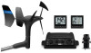
...can display NMEA 0183 data from sources connected to water of the National Marine Electronics Association. NMEA 2000 Connection Considerations The marine instrument connects to the marine instrument and data from NMEA 2000 devices such as a wind or boat speed sensor GND 10 black box bridge ... Specifications Specification Dimensions without sun cover (H×W×D) Dimensions with sun cover (H×W×D) Weight without the express permission of Garmin Ltd. The NMEA 2000 network provides power to a NMEA 2000 network on the same NMEA 2000 network. Specification Material Water...
...can display NMEA 0183 data from sources connected to water of the National Marine Electronics Association. NMEA 2000 Connection Considerations The marine instrument connects to the marine instrument and data from NMEA 2000 devices such as a wind or boat speed sensor GND 10 black box bridge ... Specifications Specification Dimensions without sun cover (H×W×D) Dimensions with sun cover (H×W×D) Weight without the express permission of Garmin Ltd. The NMEA 2000 network provides power to a NMEA 2000 network on the same NMEA 2000 network. Specification Material Water...
