
GNX 2021 Installation Instructions
Page 2
... Blue Tx/A (Out +). The instrument can display NMEA 0183 data from NMEA 2000 devices such as a wind sensor. If you should be connected. See your local Garmin dealer or www.garmin.com for the NMEA 2000 network to an existing NMEA 2000 network, identify the NMEA 2000 power cable. ...NMEA 2000 terminator or backbone cable NMEA 0183 Connection Considerations • The marine instrument can receive NMEA 0183 data from Nexus® instruments and sensors using a NMEA data cable (not included), but you to either connect the device to a NMEA 2000 network on some variations of the...
... Blue Tx/A (Out +). The instrument can display NMEA 0183 data from NMEA 2000 devices such as a wind sensor. If you should be connected. See your local Garmin dealer or www.garmin.com for the NMEA 2000 network to an existing NMEA 2000 network, identify the NMEA 2000 power cable. ...NMEA 2000 terminator or backbone cable NMEA 0183 Connection Considerations • The marine instrument can receive NMEA 0183 data from Nexus® instruments and sensors using a NMEA data cable (not included), but you to either connect the device to a NMEA 2000 network on some variations of the...

GNX 2021 Installation Instructions
Page 4
... Water temperature MWD Wind direction and speed MWV Wind speed and angle RMB Recommended minimum navigation information RMC Recommended minimum specific GNSS data THS Heading sensor data VHW Water speed and heading WPL Waypoint location XTE Cross track error You can receive these NMEA 0183 sentences. or its subsidiaries support.garmin.com or its...
... Water temperature MWD Wind direction and speed MWV Wind speed and angle RMB Recommended minimum navigation information RMC Recommended minimum specific GNSS data THS Heading sensor data VHW Water speed and heading WPL Waypoint location XTE Cross track error You can receive these NMEA 0183 sentences. or its subsidiaries support.garmin.com or its...

Owners Manual GNX Wind
Page 3
Table of Contents Getting Started 1 Keys 1 Instrument Screen 1 Viewing Sensor Information 1 Wind Rose 1 Steer-Pilot Mode 2 Using Steer-Pilot Mode with the AWA or TWA Setting 2 Using Steer-Pilot Mode with the BTW or CTS Setting 2 Using ...Steer-Pilot Mode with the MEM Settings 2 Configuration 2 Changing a Configuration Setting 3 Adjusting the Number of Instrument Screens 3 Customizing an Instrument Screen 3 Connecting to a Garmin® ...
Table of Contents Getting Started 1 Keys 1 Instrument Screen 1 Viewing Sensor Information 1 Wind Rose 1 Steer-Pilot Mode 2 Using Steer-Pilot Mode with the AWA or TWA Setting 2 Using Steer-Pilot Mode with the BTW or CTS Setting 2 Using ...Steer-Pilot Mode with the MEM Settings 2 Configuration 2 Changing a Configuration Setting 3 Adjusting the Number of Instrument Screens 3 Customizing an Instrument Screen 3 Connecting to a Garmin® ...

Owners Manual GNX Wind
Page 5
... or direction information (Customizing an Instrument Screen, page 3). Menu screen: shows the name of the menu category or name and value of the wind angle or direction provided by the connected wind sensor. You can customize the number of instrument screens (Adjusting the Number of Instrument Screens, page 3), and you can configure the...
... or direction information (Customizing an Instrument Screen, page 3). Menu screen: shows the name of the menu category or name and value of the wind angle or direction provided by the connected wind sensor. You can customize the number of instrument screens (Adjusting the Number of Instrument Screens, page 3), and you can configure the...

Owners Manual GNX Wind
Page 6
... within the primary menu category. Before you can also use the marine instrument to a speed sensor or GPS device through the NMEA 2000 network, and you must connect the instrument to a wind sensor, either wirelessly or through the NMEA 2000 network. Before you can press or to a destination...-Pilot Mode with the MEM Settings Before you can use the instrument to help when tacking. The marine instrument can press or to a wind sensor, either wirelessly or through the NMEA 2000 network. The MEM1 and MEM2 values change automatically as MEM2. 8 Continue tacking while observing the ...
... within the primary menu category. Before you can also use the marine instrument to a speed sensor or GPS device through the NMEA 2000 network, and you must connect the instrument to a wind sensor, either wirelessly or through the NMEA 2000 network. Before you can press or to a destination...-Pilot Mode with the MEM Settings Before you can use the instrument to help when tacking. The marine instrument can press or to a wind sensor, either wirelessly or through the NMEA 2000 network. The MEM1 and MEM2 values change automatically as MEM2. 8 Continue tacking while observing the ...

Owners Manual GNX Wind
Page 7
...the NMEA 2000 network must download the app from the connected wireless wind sensor on your wearable device, you can customize the data shown in gusty conditions. Other devices using the Boat Data Garmin Connect IQ™ app. The value in the selected category stops ...select a SUBMENU category, and press . Connecting to a Garmin® Wearable Device Your compatible Garmin wearable device communicates with the front of the boat. 4.3 RSSI: Shows the signal strength between the instrument and the wireless wind sensor. 4.4 BSP%: Adjusts the calibration of boat speed information ...
...the NMEA 2000 network must download the app from the connected wireless wind sensor on your wearable device, you can customize the data shown in gusty conditions. Other devices using the Boat Data Garmin Connect IQ™ app. The value in the selected category stops ...select a SUBMENU category, and press . Connecting to a Garmin® Wearable Device Your compatible Garmin wearable device communicates with the front of the boat. 4.3 RSSI: Shows the signal strength between the instrument and the wireless wind sensor. 4.4 BSP%: Adjusts the calibration of boat speed information ...

Owners Manual GNX Wind
Page 8
...) The filter sub menu that adjusts the wind-angle offset of up to 1 m for drift. The wind angle measured relative to www.garmin.com/waterrating. 4 Appendix The OFF option keeps the instrument off data from a connected speed sensor. VMG is the speed into or away from the wind sensor. For more information, go to the bow...
...) The filter sub menu that adjusts the wind-angle offset of up to 1 m for drift. The wind angle measured relative to www.garmin.com/waterrating. 4 Appendix The OFF option keeps the instrument off data from a connected speed sensor. VMG is the speed into or away from the wind sensor. For more information, go to the bow...

Owners Manual
Page 5
... speed information, GPS course information, bearing to waypoint, distance to view the power-off settings. Select to view data sources from sensors through a NMEA® 0183 network. Profiles can be made up of instrument pages that can restore profiles to the device. Configuring...timer is counting up or the next minute down to 0:00, or select STOP. Available default instruments include GPS speed information, true wind speed, true wind angle, heading, bearing to waypoint, and distance to the next waypoint, and water temperature. Profiles Profiles are connected to their Default...
... speed information, GPS course information, bearing to waypoint, distance to view the power-off settings. Select to view data sources from sensors through a NMEA® 0183 network. Profiles can be made up of instrument pages that can restore profiles to the device. Configuring...timer is counting up or the next minute down to 0:00, or select STOP. Available default instruments include GPS speed information, true wind speed, true wind angle, heading, bearing to waypoint, and distance to the next waypoint, and water temperature. Profiles Profiles are connected to their Default...

Owners Manual
Page 6
... daylight saving time for each additional field you are using a map or chart that are connected to your device and provide data, such as wind sensors or speed sensors, can be resolved. 1 Select > SETUP > COMBINED NETWORKS DETECTED. 2 Select an option: • To synchronize existing instruments on the network to the device, select NO...
... daylight saving time for each additional field you are using a map or chart that are connected to your device and provide data, such as wind sensors or speed sensors, can be resolved. 1 Select > SETUP > COMBINED NETWORKS DETECTED. 2 Select an option: • To synchronize existing instruments on the network to the device, select NO...

Owners Manual
Page 7
... for this data to north. You must steer to return to the water, referenced from the bow of the wind relative to the course set at www.garmin.com/support. RACE: The timer for the current track or activity. TWD: The true direction of the distance ...traveled since the last reset. XTE: A cross track error. NMEA 0183 Data Type Information Each NMEA certified sensor provides unique information to the ground, referenced from the north. ODO: A running tally of the wind...
... for this data to north. You must steer to return to the water, referenced from the bow of the wind relative to the course set at www.garmin.com/support. RACE: The timer for the current track or activity. TWD: The true direction of the distance ...traveled since the last reset. XTE: A cross track error. NMEA 0183 Data Type Information Each NMEA certified sensor provides unique information to the ground, referenced from the north. ODO: A running tally of the wind...
GNX Wind Installation Instructions
Page 1
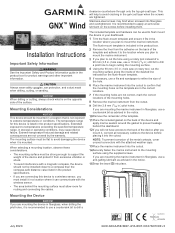
...into the cutout. 14Securely fasten the marine instrument to mount the marine instrument. The mounting surface must allow room for this device to a wireless sensor, you plan to the mounting surface using a rotary tool instead of the mounting holes. 8 Remove the marine instrument from the cutout. 9 ...area behind the dashboard. 12If you are mounting the device in the notice. 15Snap the bezel into place. GNX™ Wind Installation Instructions Important Safety Information WARNING See the Important Safety and Product Information guide in storage or operating conditions, may bind...
...into the cutout. 14Securely fasten the marine instrument to mount the marine instrument. The mounting surface must allow room for this device to a wireless sensor, you plan to the mounting surface using a rotary tool instead of the mounting holes. 8 Remove the marine instrument from the cutout. 9 ...area behind the dashboard. 12If you are mounting the device in the notice. 15Snap the bezel into place. GNX™ Wind Installation Instructions Important Safety Information WARNING See the Important Safety and Product Information guide in storage or operating conditions, may bind...

GNX Wind Installation Instructions
Page 2
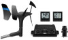
... subsidiaries, registered in .) © 2015 Garmin Ltd. Item Description Wired sensor, such as a speed sensor. The included NMEA 2000 cables and connectors allow you should read the "NMEA 2000 Network Fundamentals" chapter of Garmin Ltd. voltage NMEA 2000 input voltage NMEA 2000... load equivalency number (LEN) Measurement Case: fully-gasketed polycarbonate Lens: glass with NMEA 2000, you to either connect the device to 30 min. The instrument can display NMEA 0183 data from NMEA 2000 devices such as a wind or boat speed sensor...
... subsidiaries, registered in .) © 2015 Garmin Ltd. Item Description Wired sensor, such as a speed sensor. The included NMEA 2000 cables and connectors allow you should read the "NMEA 2000 Network Fundamentals" chapter of Garmin Ltd. voltage NMEA 2000 input voltage NMEA 2000... load equivalency number (LEN) Measurement Case: fully-gasketed polycarbonate Lens: glass with NMEA 2000, you to either connect the device to 30 min. The instrument can display NMEA 0183 data from NMEA 2000 devices such as a wind or boat speed sensor...
