
Owners Manual
Page 10
Move to the object, and select Done > Save. 10 eTrex Owner's Manual Point the device at an object in the distance, lock in the direction of a location. 3. Select Lock Direction > Project Waypoint. 4. Enter the... navigate to the object. 1. Waypoints, Routes, and Tracks Increasing the Accuracy of a Waypoint Location Waypoint averaging allows you to increase the accuracy of a waypoint location by collecting multiple samples of measure. 5. Select Start. 5. Using Sight 'N Go Sight 'N Go is available on the eTrex 30x. Select a unit of the waypoint location. 1. For best results,...
Move to the object, and select Done > Save. 10 eTrex Owner's Manual Point the device at an object in the distance, lock in the direction of a location. 3. Select Lock Direction > Project Waypoint. 4. Enter the... navigate to the object. 1. Waypoints, Routes, and Tracks Increasing the Accuracy of a Waypoint Location Waypoint averaging allows you to increase the accuracy of a waypoint location by collecting multiple samples of measure. 5. Select Start. 5. Using Sight 'N Go Sight 'N Go is available on the eTrex 30x. Select a unit of the waypoint location. 1. For best results,...

Owners Manual
Page 17
...the device is only available on the map, and the bar at the top of the map. • Select a location on the eTrex 20x and eTrex 30x. You can use an auto mount accessory with the device, you must purchase and load City Navigator maps. Navigating a Driving Route Driving... route navigation is using the automotive profile, the compass displays GPS heading, not magnetic heading. To improve heading accuracy, do not ...
...the device is only available on the map, and the bar at the top of the map. • Select a location on the eTrex 20x and eTrex 30x. You can use an auto mount accessory with the device, you must purchase and load City Navigator maps. Navigating a Driving Route Driving... route navigation is using the automotive profile, the compass displays GPS heading, not magnetic heading. To improve heading accuracy, do not ...

Owners Manual
Page 26
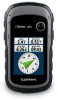
...view of the satellites to be oriented with your current location, GPS accuracy, satellite locations, and signal strength. The alarm sounds at a specific time. 1. Satellite Page The satellite page shows your current track toward the top of that satellite (eTrex 20x/30x). If necessary, select Multicolor to assign a specific color to the...not currently using the device, you can set the time, and select Done. 3. Turning Off GPS Select Satellite > menu > Use With GPS Off. 26 eTrex Owner's Manual Opening the Stopwatch Select Stopwatch. Select Turn Alarm On. 4. Select Alarm Clock. 2.
...view of the satellites to be oriented with your current location, GPS accuracy, satellite locations, and signal strength. The alarm sounds at a specific time. 1. Satellite Page The satellite page shows your current track toward the top of that satellite (eTrex 20x/30x). If necessary, select Multicolor to assign a specific color to the...not currently using the device, you can set the time, and select Done. 3. Turning Off GPS Select Satellite > menu > Use With GPS Off. 26 eTrex Owner's Manual Opening the Stopwatch Select Stopwatch. Select Turn Alarm On. 4. Select Alarm Clock. 2.
Owners Manual
Page 47
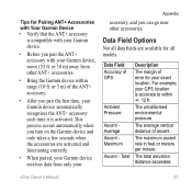
... seconds when the accessories are available for all data fields are activated and functioning correctly. • When paired, your Garmin device receives data from other accessories. eTrex Owner's Manual 47 Data Field Accuracy of ascent. The total elevation distance ascended. The average vertical distance of GPS Ambient Pressure Ascent Average Ascent Maximum Ascent...
... seconds when the accessories are available for all data fields are activated and functioning correctly. • When paired, your Garmin device receives data from other accessories. eTrex Owner's Manual 47 Data Field Accuracy of ascent. The total elevation distance ascended. The average vertical distance of GPS Ambient Pressure Ascent Average Ascent Maximum Ascent...
