
Manual - English
Page 6
... trip 19 Editing a multiple destination trip 20 Magellan CrossoverGPS 1 What the Magellan CrossoverGPS can do for you 1 Magellan CrossoverGPS Reference Manual 2 Magellan CrossoverGPS 2 Magellan CrossoverGPS Right Side View 3 Magellan CrossoverGPS Left Side View 3 Magellan CrossoverGPS Application Menu Screen 4 The Application Menu 4 Accessing the Application Menu 5 Satellite Status ...5 Magellan CrossoverGPS Vehicle Navigation Screens 6 Map Screen ...6 Main Menu Screens 7 Main Menu...
... trip 19 Editing a multiple destination trip 20 Magellan CrossoverGPS 1 What the Magellan CrossoverGPS can do for you 1 Magellan CrossoverGPS Reference Manual 2 Magellan CrossoverGPS 2 Magellan CrossoverGPS Right Side View 3 Magellan CrossoverGPS Left Side View 3 Magellan CrossoverGPS Application Menu Screen 4 The Application Menu 4 Accessing the Application Menu 5 Satellite Status ...5 Magellan CrossoverGPS Vehicle Navigation Screens 6 Map Screen ...6 Main Menu Screens 7 Main Menu...

Manual - English
Page 7
Deleting a multiple destination trip 21 Renaming a multiple destination trip 21 Magellan CrossoverGPS Enhanced POIs 22 Overview ...22 Accessing the Enhanced POI Menu 22 Loading an Enhanced POI file 22 Displaying/Selecting Categories 22 Setting Alarms ...22 ... Compass Screen 27 Creating a Waypoint from the Marine Navigation Menu 27 Setting your Port ...28 Going to your Port 28 Creating a Goto Route from the Map Screen 28 Creating a Goto Route from the Marine Navigation Menu 29 Creating a Trip ...29 Activating a Trip ...30 Track Tools ...30 Bow View ...31 Accessing the...
Deleting a multiple destination trip 21 Renaming a multiple destination trip 21 Magellan CrossoverGPS Enhanced POIs 22 Overview ...22 Accessing the Enhanced POI Menu 22 Loading an Enhanced POI file 22 Displaying/Selecting Categories 22 Setting Alarms ...22 ... Compass Screen 27 Creating a Waypoint from the Marine Navigation Menu 27 Setting your Port ...28 Going to your Port 28 Creating a Goto Route from the Map Screen 28 Creating a Goto Route from the Marine Navigation Menu 29 Creating a Trip ...29 Activating a Trip ...30 Track Tools ...30 Bow View ...31 Accessing the...

Manual - English
Page 8
... ...40 Address Book Options (Waypoint Options in Marine and Outdoor 40 Active Track Options (Marine and Outdoor only 40 Map Options ...41 Map Colors (Vehicle Navigation only 41 Route Preferences (Vehicle Navigation only 41 Detour Options (Vehicle Navigation only 42 Simulator Mode ...(Vehicle Navigation only 42 Menu Colors ...42 Tone Options ...43 Navigation Instruction (Vehicle Navigation only 43 GPS Options ...43 Backup and Restore (...
... ...40 Address Book Options (Waypoint Options in Marine and Outdoor 40 Active Track Options (Marine and Outdoor only 40 Map Options ...41 Map Colors (Vehicle Navigation only 41 Route Preferences (Vehicle Navigation only 41 Detour Options (Vehicle Navigation only 42 Simulator Mode ...(Vehicle Navigation only 42 Menu Colors ...42 Tone Options ...43 Navigation Instruction (Vehicle Navigation only 43 GPS Options ...43 Backup and Restore (...

Manual - English
Page 12
... Connects power to store music and photos as well as optional region maps. External Power Input - (under protective cover) Should the Magellan CrossoverGPS not function or during firmware updates you may be used for use where the Magellan CrossoverGPS might be in the up position.) Hold Button - (under ...for outdoor use of the display and sets the receiver into a power saving mode. The SD card can be required to reset the unit. (The Magellan CrossoverGPS will operate only if the reset switch is in a pocket or backpack. Magellan CrossoverGPS Right Side View Power - Press and hold...
... Connects power to store music and photos as well as optional region maps. External Power Input - (under protective cover) Should the Magellan CrossoverGPS not function or during firmware updates you may be used for use where the Magellan CrossoverGPS might be in the up position.) Hold Button - (under ...for outdoor use of the display and sets the receiver into a power saving mode. The SD card can be required to reset the unit. (The Magellan CrossoverGPS will operate only if the reset switch is in a pocket or backpack. Magellan CrossoverGPS Right Side View Power - Press and hold...

Manual - English
Page 13
...provide you with turn driving instructions using the built-in street maps. The Photos button opens the Photo Viewer application where you can view photos that you can store on an optional SD card. Magellan CrossoverGPS Application Menu 4 The Music button opens the Music ...Player application where you can play MP3 files that you need for your Magellan CrossoverGPS. The Outdoor button takes you to the Outdoor Navigation application in applications. The Magellan CrossoverGPS has 90 meter topographic maps included for the 48 contiguous United States. Photos - More detailed (30 ...
...provide you with turn driving instructions using the built-in street maps. The Photos button opens the Photo Viewer application where you can view photos that you can store on an optional SD card. Magellan CrossoverGPS Application Menu 4 The Music button opens the Music ...Player application where you can play MP3 files that you need for your Magellan CrossoverGPS. The Outdoor button takes you to the Outdoor Navigation application in applications. The Magellan CrossoverGPS has 90 meter topographic maps included for the 48 contiguous United States. Photos - More detailed (30 ...

Manual - English
Page 15
... the unit of your heading as N, NE, NW, W, etc. At the posted speed limit, the turn on the Magellan CrossoverGPS. When tapped repeats the last verbal instruction. Magellan CrossoverGPS Vehicle Navigation Screens Map Screen The Map Screen is the icon When tapped, offers you the option for a restaurant. Whether you are getting directions or...
... the unit of your heading as N, NE, NW, W, etc. At the posted speed limit, the turn on the Magellan CrossoverGPS. When tapped repeats the last verbal instruction. Magellan CrossoverGPS Vehicle Navigation Screens Map Screen The Map Screen is the icon When tapped, offers you the option for a restaurant. Whether you are getting directions or...

Manual - English
Page 16
When tapped, displays the maneuver list screen. When tapped, zooms in the map display. active route and normal. With no active route, the Main Menu provides access to functions that pertain to next maneuver and remaining distance of ... Street Name 11 Volume Zoom In 12 Displays the name of the street that the next maneuver will occur. Active Route 2 3 4 1 12 11 10 10 5 6 7 8 9 Magellan Crossover Vehicle Navigation Screens 7 Tapping this button toggles the field between time to the route. Main Menu Screens The Main Menu has two modes; 8 Time...
When tapped, displays the maneuver list screen. When tapped, zooms in the map display. active route and normal. With no active route, the Main Menu provides access to functions that pertain to next maneuver and remaining distance of ... Street Name 11 Volume Zoom In 12 Displays the name of the street that the next maneuver will occur. Active Route 2 3 4 1 12 11 10 10 5 6 7 8 9 Magellan Crossover Vehicle Navigation Screens 7 Tapping this button toggles the field between time to the route. Main Menu Screens The Main Menu has two modes; 8 Time...

Manual - English
Page 17
... the trip computer feature providing information about the trip that are near upcoming freeway exits. (Only used while travelling on . Magellan Crossover Vehicle Navigation Screens 8 Displays a bar graph indicating satellite When tapped displays the signal strength. Functional only when travelling on... . Provides access to tools to a listing of the route main menu. The Magellan CrossoverGPS will automatically attempt to access the Map Screen Detour gives you the option of rerouting the trip around traffic problems ahead of the route main...
... the trip computer feature providing information about the trip that are near upcoming freeway exits. (Only used while travelling on . Magellan Crossover Vehicle Navigation Screens 8 Displays a bar graph indicating satellite When tapped displays the signal strength. Functional only when travelling on... . Provides access to tools to a listing of the route main menu. The Magellan CrossoverGPS will automatically attempt to access the Map Screen Detour gives you the option of rerouting the trip around traffic problems ahead of the route main...

Manual - English
Page 18
... indicating satellite signal strength. Save your home address in the Magellan CrossoverGPS. Create a route to access additional map regions stored in the Magellan CrossoverGPS and easily create a trip with your home as the destination. No Active Route 2 3 4 1 14 13 15 12 5 6 7 8 9 10 11 Map Button 1 2 Street Address Button 3 POI Button 4 Satellite Status 5 Home Button...
... indicating satellite signal strength. Save your home address in the Magellan CrossoverGPS. Create a route to access additional map regions stored in the Magellan CrossoverGPS and easily create a trip with your home as the destination. No Active Route 2 3 4 1 14 13 15 12 5 6 7 8 9 10 11 Map Button 1 2 Street Address Button 3 POI Button 4 Satellite Status 5 Home Button...

Manual - English
Page 19
...the screen shows a compass, the elevation (if able to the Map screen. Tap the "X" in the upper right corner to return to compute) and the speed you are travelling. Used to access personal POIs created with the Magellan PC Toolkit Used to reach your address book. The right side ...of the maneuvers remaining to do to create a multidestination trip that can be saved. Tap on the Map screen) The Locate screen displays information about previous trips ...
...the screen shows a compass, the elevation (if able to the Map screen. Tap the "X" in the upper right corner to return to compute) and the speed you are travelling. Used to access personal POIs created with the Magellan PC Toolkit Used to reach your address book. The right side ...of the maneuvers remaining to do to create a multidestination trip that can be saved. Tap on the Map screen) The Locate screen displays information about previous trips ...
Manual - English
Page 20
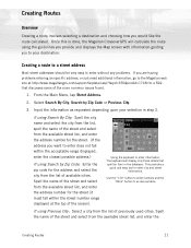
...and enter the address number for a FAQ that spell an item in step 2. If using the guidelines you provide and displays the Map screen with information guiding you are having problems entering an specific address, or just need additional information, go to your selection in ... range displayed, enter the closest possible address.) If using Search by Zip Code or Previous City. 3. Once this is done, the Magellan CrossoverGPS will display only those letters that discusses some of the screen). Creating Routes Overview Creating a route involves selecting a destination and choosing...
...and enter the address number for a FAQ that spell an item in step 2. If using the guidelines you provide and displays the Map screen with information guiding you are having problems entering an specific address, or just need additional information, go to your selection in ... range displayed, enter the closest possible address.) If using Search by Zip Code or Previous City. 3. Once this is done, the Magellan CrossoverGPS will display only those letters that discusses some of the screen). Creating Routes Overview Creating a route involves selecting a destination and choosing...

Manual - English
Page 26
Tap Save to store the changes into your finger or stylus to pan the crosshair cursor around the map. If you do a search, you will be asked to enter the first few times to return to the Main Menu if you want to add ... Address, Dining, ATM, Gas.. 5. Confirm the deletion by tapping on the crosshair cursor. Select Select on Map: The Map screen is over the point on the map you are done. Tap List Addresses 3. When the crosshair cursor is displayed. You can change the address information. From the Main Menu, tap Address Book. 2. ...
Tap Save to store the changes into your finger or stylus to pan the crosshair cursor around the map. If you do a search, you will be asked to enter the first few times to return to the Main Menu if you want to add ... Address, Dining, ATM, Gas.. 5. Confirm the deletion by tapping on the crosshair cursor. Select Select on Map: The Map screen is over the point on the map you are done. Tap List Addresses 3. When the crosshair cursor is displayed. You can change the address information. From the Main Menu, tap Address Book. 2. ...
Manual - English
Page 33
... MapSend BlueNav Local Charts and any external maps (Magellan BlueNav) you want to select a region from Magellan at http://www.magellangps.com/ products/software.asp. Marine Map with the BlueNav Chart into the SD card slot on the left side of the Magellan BlueNav charts you turn it on, a... in the lower right corner to your marine trip. Tap Yes. 4. Changing Regions 1. Marine Navigation 24 The Magellan CrossoverGPS is on the SD card. 3. Select the map you can enhance your point of the eXplorist MapSend BlueNav XL3 Charts. (Meridian MapSend BlueNav XL3 charts will have...
... MapSend BlueNav Local Charts and any external maps (Magellan BlueNav) you want to select a region from Magellan at http://www.magellangps.com/ products/software.asp. Marine Map with the BlueNav Chart into the SD card slot on the left side of the Magellan BlueNav charts you turn it on, a... in the lower right corner to your marine trip. Tap Yes. 4. Changing Regions 1. Marine Navigation 24 The Magellan CrossoverGPS is on the SD card. 3. Select the map you can enhance your point of the eXplorist MapSend BlueNav XL3 Charts. (Meridian MapSend BlueNav XL3 charts will have...

Manual - English
Page 34
... a history of your travels. When you look at the map screen you will notice a dotted line showing you want to leave the port and...the street name and number, the city, and the state to the fishing hotspot you move across the water the Magellan CrossoverGPS drops and records electronic breadcrumbs that follows this track back to where you to load. Trip A trip is ... goto is a route with two destinations (or two legs). Backtrack As explained above, the Magellan CrossoverGPS records your present position to pinpoint its location, while a waypoint uses imaginary lines drawn on the...
... a history of your travels. When you look at the map screen you will notice a dotted line showing you want to leave the port and...the street name and number, the city, and the state to the fishing hotspot you move across the water the Magellan CrossoverGPS drops and records electronic breadcrumbs that follows this track back to where you to load. Trip A trip is ... goto is a route with two destinations (or two legs). Backtrack As explained above, the Magellan CrossoverGPS records your present position to pinpoint its location, while a waypoint uses imaginary lines drawn on the...

Manual - English
Page 35
...display the Marine Navigation menu. Map Screen Overview 1 2 3 4 5 1 Information Bar 2 Zoom out 3 Position Icon North Indicator 4 Data field 5 6 Map Scale MENU button 7 Create Waypoint 8 9 Brightness 10 Zoom In 11 Satellite Status 11 10 9 8 7 6 Displays information for the map. A list of your current ... a waypoint. Tap to save your current position. Displays the current distance scale for the cursor position while panning around the map. When tapped displays a slider bar that can also create a goto route to adjust the display brightness. Tap and hold for...
...display the Marine Navigation menu. Map Screen Overview 1 2 3 4 5 1 Information Bar 2 Zoom out 3 Position Icon North Indicator 4 Data field 5 6 Map Scale MENU button 7 Create Waypoint 8 9 Brightness 10 Zoom In 11 Satellite Status 11 10 9 8 7 6 Displays information for the map. A list of your current ... a waypoint. Tap to save your current position. Displays the current distance scale for the cursor position while panning around the map. When tapped displays a slider bar that can also create a goto route to adjust the display brightness. Tap and hold for...

Manual - English
Page 36
...the method selected to edit the name, lat/lon, altitude or information. 6. Tap 2. Tap 2. A waypoint is created and indicated by an 'x' on Map to visually place the waypoint or Enter Lat/Lon to edit the name, lat/lon, altitude or information. 3. Creating a Waypoint from the Compass Screen 1. ... to edit the name, lat/lon, altitude or information. 4. Tap Save. 6. Tap 2. Select Create New Entry. 3. Tap 3. Tap on the map. A waypoint is created and indicated by an 'x' on any of the fields to locate or enter the waypoint position. 5. Tap on any of the...
...the method selected to edit the name, lat/lon, altitude or information. 6. Tap 2. Tap 2. A waypoint is created and indicated by an 'x' on Map to visually place the waypoint or Enter Lat/Lon to edit the name, lat/lon, altitude or information. 3. Creating a Waypoint from the Compass Screen 1. ... to edit the name, lat/lon, altitude or information. 4. Tap Save. 6. Tap 2. Select Create New Entry. 3. Tap 3. Tap on the map. A waypoint is created and indicated by an 'x' on any of the fields to locate or enter the waypoint position. 5. Tap on any of the...

Manual - English
Page 37
...visually place your port on any of the fields to your Favorites list. 7. Creating a Goto Route from the map or enter it's latitude and longitude. 3. Setting your port. 4. Tap Save. The Map screen is the first time you have accessed the Port function you want to go to edit the name, ...lat/lon, altitude or information. 6. Tap on the map or Enter Lat/Lon to either select the port from the Map Screen 1. Navigate along the map to the location you will be asked to type in your destination waypoint. Pan the cursor along this...
...visually place your port on any of the fields to your Favorites list. 7. Creating a Goto Route from the map or enter it's latitude and longitude. 3. Setting your port. 4. Tap Save. The Map screen is the first time you have accessed the Port function you want to go to edit the name, ...lat/lon, altitude or information. 6. Tap on the map or Enter Lat/Lon to either select the port from the Map Screen 1. Navigate along the map to the location you will be asked to type in your destination waypoint. Pan the cursor along this...

Manual - English
Page 38
... this line to go to find the desired waypoint. 4. Tap on the waypoint name from Previous Destinations, Favorites, List Waypoints or Create New Entry. 6. The Map screen is selected, select List Waypoints again or use the search feature to your destination waypoint. Tap Save. 10. If List Waypoints is displayed with...
... this line to go to find the desired waypoint. 4. Tap on the waypoint name from Previous Destinations, Favorites, List Waypoints or Create New Entry. 6. The Map screen is selected, select List Waypoints again or use the search feature to your destination waypoint. Tap Save. 10. If List Waypoints is displayed with...

Manual - English
Page 39
The map is displayed. Activating a Trip 1. Select Guide Me. 3. Tap on the first waypoint in the.... • Tap Back Track to create a route that follows your active track as a trip that can be visible on the map while navigating. Marine Navigation 30 From the Marine Navigation menu, tap 2. Tap on the entire trip. 5. to save your active ...again later. • Tap View on Map to see the entire active track displayed on the map. • Tap Color to use. 4. Track Tools 1. A list of the track line displayed on the map. • Show on Map sets the track to save your active ...
The map is displayed. Activating a Trip 1. Select Guide Me. 3. Tap on the first waypoint in the.... • Tap Back Track to create a route that follows your active track as a trip that can be visible on the map while navigating. Marine Navigation 30 From the Marine Navigation menu, tap 2. Tap on the entire trip. 5. to save your active ...again later. • Tap View on Map to see the entire active track displayed on the map. • Tap Color to use. 4. Track Tools 1. A list of the track line displayed on the map. • Show on Map sets the track to save your active ...
Manual - English
Page 41
...the SD card. 3. If the unit is compatible with the Magellan CrossoverGPS.) Loading MapSend Topo Charts 1. Outdoor Map without a MapSend Topo map loaded. Magellan MapSend Topo maps are NOT compatible with MapSend Topo maps that maps have an active trip or goto you turn it before being able...a CD-ROM or DVD are available from the SD card. 2. Changing Regions 1. The Magellan CrossoverGPS has 90 meter topographic maps installed for hiking and camping. Without loading any external maps (Magellan MapSend Topo) you want to cancel it on, a message will be displayed that are ...
...the SD card. 3. If the unit is compatible with the Magellan CrossoverGPS.) Loading MapSend Topo Charts 1. Outdoor Map without a MapSend Topo map loaded. Magellan MapSend Topo maps are NOT compatible with MapSend Topo maps that maps have an active trip or goto you turn it before being able...a CD-ROM or DVD are available from the SD card. 2. Changing Regions 1. The Magellan CrossoverGPS has 90 meter topographic maps installed for hiking and camping. Without loading any external maps (Magellan MapSend Topo) you want to cancel it on, a message will be displayed that are ...


