Manual - English
Page 7
... Getting Software Version Information 40 Viewing Copyright Information 40 Personalizing Magellan Triton 40 Performing Diagnostic Checks 40 Geocache Waypoints ...42 Creating a Geocache Waypoint 42 Editing a Saved Geocache Waypoint 42 Deleting a Saved Geocache Waypoint 43 Deleting a Saved Geocache Waypoint (Alternate Method 43 Deleting All Saved Geocache Waypoints 44 Duplicating a Saved Geocache Waypoint 44 Routes ...45 Go To Routes ...45 Creating...
... Getting Software Version Information 40 Viewing Copyright Information 40 Personalizing Magellan Triton 40 Performing Diagnostic Checks 40 Geocache Waypoints ...42 Creating a Geocache Waypoint 42 Editing a Saved Geocache Waypoint 42 Deleting a Saved Geocache Waypoint 43 Deleting a Saved Geocache Waypoint (Alternate Method 43 Deleting All Saved Geocache Waypoints 44 Duplicating a Saved Geocache Waypoint 44 Routes ...45 Go To Routes ...45 Creating...

Manual - English
Page 14
... SD card (400 & 500) or into the Magellan Triton. From the Map Screen, press MENU. The Place option is used to create waypoints and multileg routes that has been either preloaded into the Magellan Triton as part of the Magellan Triton is a saved track.) The Geocache option allows you want the Triton to not turn off with... keys have been pressed. You can select the trail that has been loaded on the map or by the Magellan Triton. You can also select Off if you to select a saved geocache waypoint and use it as the Go To Menu but these menu options brings up the menu for a Go...
... SD card (400 & 500) or into the Magellan Triton. From the Map Screen, press MENU. The Place option is used to create waypoints and multileg routes that has been either preloaded into the Magellan Triton as part of the Magellan Triton is a saved track.) The Geocache option allows you want the Triton to not turn off with... keys have been pressed. You can select the trail that has been loaded on the map or by the Magellan Triton. You can also select Off if you to select a saved geocache waypoint and use it as the Go To Menu but these menu options brings up the menu for a Go...
Manual - English
Page 15
... access to your current journey. hiking, marine use again to access navigation settings, adjust volume and brightness, select connectivity, view memory details, as well as a route that are creating audio clips and playing MP3 music files. (Magellan Triton 400 & 500 only). Other functions of the ...Place option is used to close the contextual menu. The Trips option will be available in the Magellan Triton from earlier trips, or waypoints that you can use or geocaching. The View Menu has options for a particular activity; Navigation Screen options menus The Map and ...
... access to your current journey. hiking, marine use again to access navigation settings, adjust volume and brightness, select connectivity, view memory details, as well as a route that are creating audio clips and playing MP3 music files. (Magellan Triton 400 & 500 only). Other functions of the ...Place option is used to close the contextual menu. The Trips option will be available in the Magellan Triton from earlier trips, or waypoints that you can use or geocaching. The View Menu has options for a particular activity; Navigation Screen options menus The Map and ...

Manual - English
Page 32
...ESC to return to change. 5. Speed can be displayed as the unit of measure for distances. Elevation can be measured in Meters or Feet. (Magellan Triton 500 only) Choose between showing four data fields, two data fields or turning them off . (Even if the track line is the header bar shown..., or Track Up. ORIENTATION QUICK INFO MAP DATA FIELDS POSITION DESTINATION LINE WAYPOINTS SHOWN GEOCACHES SHOWN POIs SHOWN TRACK LINES MAP DETAILS Set the top of the display to highlight the choice desired. 7. Geocache waypoints on the map can be set to your needs. Changing Map Units of the...
...ESC to return to change. 5. Speed can be displayed as the unit of measure for distances. Elevation can be measured in Meters or Feet. (Magellan Triton 500 only) Choose between showing four data fields, two data fields or turning them off . (Even if the track line is the header bar shown..., or Track Up. ORIENTATION QUICK INFO MAP DATA FIELDS POSITION DESTINATION LINE WAYPOINTS SHOWN GEOCACHES SHOWN POIs SHOWN TRACK LINES MAP DETAILS Set the top of the display to highlight the choice desired. 7. Geocache waypoints on the map can be set to your needs. Changing Map Units of the...
Manual - English
Page 37
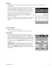
These tabs are used to select them from the GPS satellite. The Waypoint Information screen shown here has three pages with three tabs to select different pages for the function. Date Entry The Magellan Triton uses a standard calendar display to change pages use the PAGE / ... Magellan Triton since the date is highlighted, press the down arrow to move through the dates. Text Size Limitations Single-line fields: 50 characters. Page Selection Some screens like the Waypoint and Geocache Information screens, have tabs across the top of the display is automatically received from...
These tabs are used to select them from the GPS satellite. The Waypoint Information screen shown here has three pages with three tabs to select different pages for the function. Date Entry The Magellan Triton uses a standard calendar display to change pages use the PAGE / ... Magellan Triton since the date is highlighted, press the down arrow to move through the dates. Text Size Limitations Single-line fields: 50 characters. Page Selection Some screens like the Waypoint and Geocache Information screens, have tabs across the top of the display is automatically received from...

Manual - English
Page 38
... speed measurements. You will notice that you want to use the ESC button to exit. Activating a Profile 1. Profiles The Magellan Triton gives you want to edit from the Active Profile drop- Hiking, Marine and Geocaching. You can select. From the Map screen press MENU. 2. Select View. 3. Select the profile you the means to ...Kph, Mph, Kts Meters, Feet kPa, Millibar, inHg, mmHg Sets the unit of measure for distance measurements. Sets the unit of measure for elevation measurements. (Magellan Triton 500 only) Sets the unit of measure for barometric measurements. Profiles 30
... speed measurements. You will notice that you want to use the ESC button to exit. Activating a Profile 1. Profiles The Magellan Triton gives you want to edit from the Active Profile drop- Hiking, Marine and Geocaching. You can select. From the Map screen press MENU. 2. Select View. 3. Select the profile you the means to ...Kph, Mph, Kts Meters, Feet kPa, Millibar, inHg, mmHg Sets the unit of measure for distance measurements. Sets the unit of measure for elevation measurements. (Magellan Triton 500 only) Sets the unit of measure for barometric measurements. Profiles 30
Manual - English
Page 39
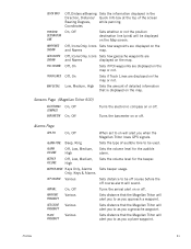
...geocache waypoints are displayed on the map or not. Sensors Page (Magellan Triton 500) ELECTRONIC COMPASS BAROMETER On, Off On, Off Turns the electronic compass on the map. Sets the volume level for the beeper. Turns the arrival alert on will alert you when the Magellan Triton loses GPS signals. Sets distance that the Magellan Triton...will alert you to as you a geocache waypoint. Turns the barometer on the Map screen. Sets distance that the Magellan Triton will be used. QUICK INFO POSITION DESTINATION LINE WAYPOINTS SHOWN GEOCACHES SHOWN POIs SHOWN TRACK LINES MAP DETAIL...
...geocache waypoints are displayed on the map or not. Sensors Page (Magellan Triton 500) ELECTRONIC COMPASS BAROMETER On, Off On, Off Turns the electronic compass on the map. Sets the volume level for the beeper. Turns the arrival alert on will alert you when the Magellan Triton loses GPS signals. Sets distance that the Magellan Triton...will alert you to as you a geocache waypoint. Turns the barometer on the Map screen. Sets distance that the Magellan Triton will be used. QUICK INFO POSITION DESTINATION LINE WAYPOINTS SHOWN GEOCACHES SHOWN POIs SHOWN TRACK LINES MAP DETAIL...
Manual - English
Page 40
... to get you use them when creating a route. Waypoints Waypoints are the key to the Triton memory. With information on the map. The Magellan Triton has three different classifications for newly created waypoints. User-Created, Place and Geocache waypoints. The Magellan Triton automatically assigns a name for the waypoint using the convention of where you define. Waypoint...
... to get you use them when creating a route. Waypoints Waypoints are the key to the Triton memory. With information on the map. The Magellan Triton has three different classifications for newly created waypoints. User-Created, Place and Geocache waypoints. The Magellan Triton automatically assigns a name for the waypoint using the convention of where you define. Waypoint...
Manual - English
Page 50
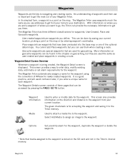
... and use the Magellan Triton to the Information page. People will have hints and descriptions included to http://www.geocaching.com or do a search on or off. 9. For additional information on geocaching and geocaching events, go to help in the Triton. 8. Geocache information includes Difficulty (1 through 5 with 5 being the most difficult), Terrain (1 though 5 with GPS users. Select from...
... and use the Magellan Triton to the Information page. People will have hints and descriptions included to http://www.geocaching.com or do a search on or off. 9. For additional information on geocaching and geocaching events, go to help in the Triton. 8. Geocache information includes Difficulty (1 through 5 with 5 being the most difficult), Terrain (1 though 5 with GPS users. Select from...

Manual - English
Page 51
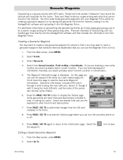
... and use the keyboard to view. From the Map screen, press MENU. 2. Change the order that waypoint.) Deleting a Saved Geocache Waypoint 1. 3. Select Geocache. 4. To do a search, select Search and using the keyboard, enter the first few characters of waypoints. 6. Select the ...you want to edit from the list of the waypoint.) 5. When the waypoint name is displayed. 8. Deleting a Saved Geocache Waypoint (Alternate Method) 1. Geocaching 43 When the waypoint name is highlighted press MENU. Select the order you want the waypoints listed, either by nearest,...
... and use the keyboard to view. From the Map screen, press MENU. 2. Change the order that waypoint.) Deleting a Saved Geocache Waypoint 1. 3. Select Geocache. 4. To do a search, select Search and using the keyboard, enter the first few characters of waypoints. 6. Select the ...you want to edit from the list of the waypoint.) 5. When the waypoint name is displayed. 8. Deleting a Saved Geocache Waypoint (Alternate Method) 1. Geocaching 43 When the waypoint name is highlighted press MENU. Select the order you want the waypoints listed, either by nearest,...

Manual - English
Page 52
.... 6. Confirm the duplication of the waypoint name. 7. Use the keyboard to save the waypoint with the new name. 10. Select Geocache. 4. Select the Delete All Geocaches from the contextual menu. 7. Select the green checkmark to enter the waypoint name. 9. 6. Select Delete Waypoint. 9. To do a... search, select Search and using the keyboard, enter the first few characters of waypoints. 5. Geocaching 44 When the waypoint name is highlighted press MENU. From the Map screen, press MENU. 2. Select Waypoint. 4. Use the PAGE / GO TO...
.... 6. Confirm the duplication of the waypoint name. 7. Use the keyboard to save the waypoint with the new name. 10. Select Geocache. 4. Select the Delete All Geocaches from the contextual menu. 7. Select the green checkmark to enter the waypoint name. 9. 6. Select Delete Waypoint. 9. To do a... search, select Search and using the keyboard, enter the first few characters of waypoints. 5. Geocaching 44 When the waypoint name is highlighted press MENU. From the Map screen, press MENU. 2. Select Waypoint. 4. Use the PAGE / GO TO...

Manual - English
Page 54
Creating a Go To Route to a Geocache Waypoint 1. Select Search to from the list of waypoints and press ENTER. Higlight the waypoint you want to go to display the keyboard and enter ... want the waypoints listed by name. Select Go To. 3. Select Create. 3. Select the Category and Subcategory. (Not all categories will have a subcategory.) 6. Select Route. Select Geocache. 4. To do a search, select Search and using the keyboard, enter the first few characters for a waypoint you want the waypoints listed, either by nearest, date...
Creating a Go To Route to a Geocache Waypoint 1. Select Search to from the list of waypoints and press ENTER. Higlight the waypoint you want to go to display the keyboard and enter ... want the waypoints listed by name. Select Go To. 3. Select Create. 3. Select the Category and Subcategory. (Not all categories will have a subcategory.) 6. Select Route. Select Geocache. 4. To do a search, select Search and using the keyboard, enter the first few characters for a waypoint you want the waypoints listed, either by nearest, date...

Manual - English
Page 55
...Route Create screen is saved and stored in the action header bar. 11. Confirm the deletion. (This does not remove the waypoint from the Triton's memory, only from the list of the route. 10. The newly created route is displayed with a graphical representation of Place waypoints and ...route. The Map screen is complete. 9. Select the green checkmark when done. 13. Point on the point desired. Geocache: Select a waypoint from the list of saved geocache waypoints and press ENTER. Select the method for determining the next destination in the list. 6. Deleting one of the ...
...Route Create screen is saved and stored in the action header bar. 11. Confirm the deletion. (This does not remove the waypoint from the Triton's memory, only from the list of the route. 10. The newly created route is displayed with a graphical representation of Place waypoints and ...route. The Map screen is complete. 9. Select the green checkmark when done. 13. Point on the point desired. Geocache: Select a waypoint from the list of saved geocache waypoints and press ENTER. Select the method for determining the next destination in the list. 6. Deleting one of the ...
