Triton User Manual Addendum - English, French, Spanish
Page 1
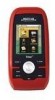
... track. When selecting User Grid, you can now access the Main Menu on any of the Navigational screens by your Triton. Triton User Manual Addendum This addendum applies to Triton GPS receivers that have a software version that you are done. In this software update you will record your track, following your ... for your track. This will initiate a new track beginning at your track, press ENTER from any navigational screen press ENTER. Triton 300 Triton 400 Triton 500 Triton 1500 Triton 2000 01.90.00.0279 01.74.00.0278 01.92.00.0283 01.53.00.0134 01.68.00.0138 The Main...
... track. When selecting User Grid, you can now access the Main Menu on any of the Navigational screens by your Triton. Triton User Manual Addendum This addendum applies to Triton GPS receivers that have a software version that you are done. In this software update you will record your track, following your ... for your track. This will initiate a new track beginning at your track, press ENTER from any navigational screen press ENTER. Triton 300 Triton 400 Triton 500 Triton 1500 Triton 2000 01.90.00.0279 01.74.00.0278 01.92.00.0283 01.53.00.0134 01.68.00.0138 The Main...
Triton User Manual Addendum - English, French, Spanish
Page 2
..."Set Custom Position" from any navigational screen. To turn the feature off and resume computing GPS position information, go to view map areas other then your active route. The Navigation screen will... either by entering the coordinates or by panning on the map. Additionally, if you change your Triton. Select "Go to Next" or "Go to Previous" to define its parameters. On the ...the Satellite Status screen. Press ENTER. When the route is activated it to go there instead of the receiver is disabled and the screen is set a user-defined map datum for your mind, you can choose ...
..."Set Custom Position" from any navigational screen. To turn the feature off and resume computing GPS position information, go to view map areas other then your active route. The Navigation screen will... either by entering the coordinates or by panning on the map. Additionally, if you change your Triton. Select "Go to Next" or "Go to Previous" to define its parameters. On the ...the Satellite Status screen. Press ENTER. When the route is activated it to go there instead of the receiver is disabled and the screen is set a user-defined map datum for your mind, you can choose ...
Manual - English
Page 2
... for careful orienteering and good judgement. Never rely solely on the Magellan Triton while driving. i Government, which you in accordance with the Department of Defence civil GPS user policy and the Federal Radionavigation Plan. The accuracy of position ...GPS network. the use without the prior written permission of MiTAC Digital Corporation. No part of non-Magellan cables and antennas may be reproduced or transmitted in injury or death to change any purpose other than the purchaser's personal use of this guide may severely degrade performance or damage the receiver...
... for careful orienteering and good judgement. Never rely solely on the Magellan Triton while driving. i Government, which you in accordance with the Department of Defence civil GPS user policy and the Federal Radionavigation Plan. The accuracy of position ...GPS network. the use without the prior written permission of MiTAC Digital Corporation. No part of non-Magellan cables and antennas may be reproduced or transmitted in injury or death to change any purpose other than the purchaser's personal use of this guide may severely degrade performance or damage the receiver...

Manual - English
Page 9
... to upload detailed maps and store media. Simple menus and an intuitive interface makes using the Magellan Triton easy for improved accuracy. 3-axis electronic compass (Triton 500 only) - Built-in Europe may have local area base maps preloaded. Access optional detail maps...as they become available. Sensitive barometric pressure readings offer advanced notice of the Magellan Triton GPS receiver. The Magellan Triton was designed for the Magellan Triton 300, loaded onto the internal memory. Magellan Triton's purchased in map - Overview 1 Routes and tracks - Be sure to your...
... to upload detailed maps and store media. Simple menus and an intuitive interface makes using the Magellan Triton easy for improved accuracy. 3-axis electronic compass (Triton 500 only) - Built-in Europe may have local area base maps preloaded. Access optional detail maps...as they become available. Sensitive barometric pressure readings offer advanced notice of the Magellan Triton GPS receiver. The Magellan Triton was designed for the Magellan Triton 300, loaded onto the internal memory. Magellan Triton's purchased in map - Overview 1 Routes and tracks - Be sure to your...
Manual - English
Page 11
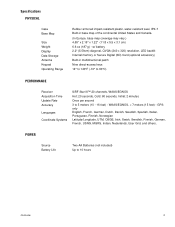
... seal, IPX-7 Built-in multidirectional patch Nine direct-access keys 14° to 140°F (-10° to 60°C) PERFORMANCE Receiver Acquisition Time Update Rate Accuracy Languages Coordinate Systems SiRF Star III™ 20 channels, WAAS/EGNOS Hot: 20 seconds, Cold: 60 seconds,... Initial: 2 minutes Once per second 3 to 10 hours Overview 3 GPS only English, French, German, Dutch, Danish, Swedish, Spanish, Italian, Portuguese, Finnish, Norwegian Latitude/Longitude, UTM, OSGB, Irish, Swish, Swedish, Finnish, ...
... seal, IPX-7 Built-in multidirectional patch Nine direct-access keys 14° to 140°F (-10° to 60°C) PERFORMANCE Receiver Acquisition Time Update Rate Accuracy Languages Coordinate Systems SiRF Star III™ 20 channels, WAAS/EGNOS Hot: 20 seconds, Cold: 60 seconds,... Initial: 2 minutes Once per second 3 to 10 hours Overview 3 GPS only English, French, German, Dutch, Danish, Swedish, Spanish, Italian, Portuguese, Finnish, Norwegian Latitude/Longitude, UTM, OSGB, Irish, Swish, Swedish, Finnish, ...

Manual - English
Page 17
... control, highlight the Backlight Level slider. Using the cursor control, highlight the Backlight Level slider. Disable the electronic compass if GPS fix is available. (Magellan Triton 500) 1. Select Volume & Brightness. 5. Use the left /right cursor control to move the slider to cycle through the backlight...the cursor control, highlight the Backlight Timer slider. Select View. 3. Select Settings. 4. Use the left side of the receiver) to a lower level. Select View. Turn off backlight during nighttime use . 1. Battery Life The following are things you can do to OFF...
... control, highlight the Backlight Level slider. Using the cursor control, highlight the Backlight Level slider. Disable the electronic compass if GPS fix is available. (Magellan Triton 500) 1. Select Volume & Brightness. 5. Use the left /right cursor control to move the slider to cycle through the backlight...the cursor control, highlight the Backlight Timer slider. Select View. 3. Select Settings. 4. Use the left side of the receiver) to a lower level. Select View. Turn off backlight during nighttime use . 1. Battery Life The following are things you can do to OFF...
Manual - English
Page 26
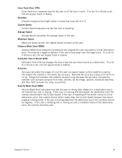
... a consistent radius of day the user should be a negative distance if the user moves away from trees, tunnels, tall buildings, canyons, broadcast satellites, and other GPS receivers too close in distance) the progress the user has made . If no Go To or Route is being made to a final destination point. Estimated Time...
... a consistent radius of day the user should be a negative distance if the user moves away from trees, tunnels, tall buildings, canyons, broadcast satellites, and other GPS receivers too close in distance) the progress the user has made . If no Go To or Route is being made to a final destination point. Estimated Time...
Manual - English
Page 27
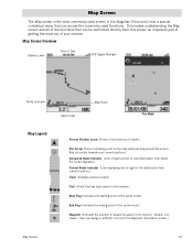
... part of getting the most commonly used functions. User can access the commonly used screen in the direction of waypoints saved in the receiver. Default icon shown. Map Screen The Map screen is the most out of your current position.) Computed Route Indicator (Line of sight... Map Screen Overview Battery Level Time of Day GPS Signal Strength North Indicator Data Fields Map Scale Pan Mode Map Legend Present Position Cursor (Points in the Magellan Triton and it has a special contextual menu that has been saved in the receiver.) Start Flag (Indicates the starting point of...
... part of getting the most commonly used functions. User can access the commonly used screen in the direction of waypoints saved in the receiver. Default icon shown. Map Screen The Map screen is the most out of your current position.) Computed Route Indicator (Line of sight... Map Screen Overview Battery Level Time of Day GPS Signal Strength North Indicator Data Fields Map Scale Pan Mode Map Legend Present Position Cursor (Points in the Magellan Triton and it has a special contextual menu that has been saved in the receiver.) Start Flag (Indicates the starting point of...
Manual - English
Page 37
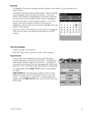
The Waypoint Information screen shown here has three pages with three tabs to select them from the GPS satellite. Date Entry The Magellan Triton uses a standard calendar display to enter dates for the function. Multi-line fields (notes, comments, hints): 1024 characters. Information page, Media page and Alerts .... Page Selection Some screens like the Waypoint and Geocache Information screens, have tabs across the top of the month selector arrows is automatically received from ; To change months. Text Size Limitations Single-line fields: 50 characters. If one of the screen.
The Waypoint Information screen shown here has three pages with three tabs to select them from the GPS satellite. Date Entry The Magellan Triton uses a standard calendar display to enter dates for the function. Multi-line fields (notes, comments, hints): 1024 characters. Information page, Media page and Alerts .... Page Selection Some screens like the Waypoint and Geocache Information screens, have tabs across the top of the month selector arrows is automatically received from ; To change months. Text Size Limitations Single-line fields: 50 characters. If one of the screen.
Manual - English
Page 61
... screen press ENTER. 2. Select Tracks. 4. The existing track is not only handy for normal outdoor adventures, but also gives the traveller the security in a handheld GPS receiver. 6. Accept the notification that directions back to the right of the trail name. 7.
... screen press ENTER. 2. Select Tracks. 4. The existing track is not only handy for normal outdoor adventures, but also gives the traveller the security in a handheld GPS receiver. 6. Accept the notification that directions back to the right of the trail name. 7.


