
Manual - English
Page 3
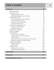
Table of Contents i eXplorist 500 GPS Receiver 1 Features of the Magellan eXplorist GPS Receiver 1 Button Descriptions 2 Installing and Charging the Battery 4 Installing an Optional SD Card 5 Connecting to a Personal Computer 5 Using the eXplorist 500 6 Going to a Destination 6 Saving Your Position 7 Tracing Your Steps 8 Additional Features 9 Summary 9 Starting Up 10 Turning the eXplorist On 10 Turning the eXplorist Off 10 Changing the Display Backlight...
Table of Contents i eXplorist 500 GPS Receiver 1 Features of the Magellan eXplorist GPS Receiver 1 Button Descriptions 2 Installing and Charging the Battery 4 Installing an Optional SD Card 5 Connecting to a Personal Computer 5 Using the eXplorist 500 6 Going to a Destination 6 Saving Your Position 7 Tracing Your Steps 8 Additional Features 9 Summary 9 Starting Up 10 Turning the eXplorist On 10 Turning the eXplorist Off 10 Changing the Display Backlight...
Manual - English
Page 4
...Personalized 32 Making POIs for Locations Other Than Your Present Position 33 Marking a Position by Entering Coordinates 33 Marking a Position using the Map Cursor 34 Marking a Position from a Map Object 34 The POI Database 35 Searching for a User-Entered POI 35 Searching for a Preloaded POI using Nearest 36 Searching for ...a Preloaded POI using Alphabetical 37 Editing a User-Created POI 38 Deleting a User-Created POI 39 Viewing a User-Created POI on the Map Screen 40 Copying a Preloaded POI 41 Viewing a Preloaded POI on the Map Screen 42 Showing or Hiding User-Entered POIs on the...
...Personalized 32 Making POIs for Locations Other Than Your Present Position 33 Marking a Position by Entering Coordinates 33 Marking a Position using the Map Cursor 34 Marking a Position from a Map Object 34 The POI Database 35 Searching for a User-Entered POI 35 Searching for a Preloaded POI using Nearest 36 Searching for ...a Preloaded POI using Alphabetical 37 Editing a User-Created POI 38 Deleting a User-Created POI 39 Viewing a User-Created POI on the Map Screen 40 Copying a Preloaded POI 41 Viewing a Preloaded POI on the Map Screen 42 Showing or Hiding User-Entered POIs on the...
Manual - English
Page 5
... of an Active Route 51 Editing a Saved Route 52 Reversing a Route 53 Deleting a Route 54 Moving a Route 55 Copying a Route 56 Viewing a Route on the Map 57 Track Logs 58 Track Logs 58 Stopping and Resuming Active Track Logging 59 Starting a New Active Track Log 60 Saving an Active Track Log... 61 Creating a BackTrack Route 62 Clearing the Active Track 63 Converting the Track Log to a Route 64 Viewing the Track Log on the Map 65 Working with Saved Track Logs 66 Following Saved Track Logs 66 Reversing a Saved Track Log 66 Deleting a Saved Track Log 67 Moving a Saved ...
... of an Active Route 51 Editing a Saved Route 52 Reversing a Route 53 Deleting a Route 54 Moving a Route 55 Copying a Route 56 Viewing a Route on the Map 57 Track Logs 58 Track Logs 58 Stopping and Resuming Active Track Logging 59 Starting a New Active Track Log 60 Saving an Active Track Log... 61 Creating a BackTrack Route 62 Clearing the Active Track 63 Converting the Track Log to a Route 64 Viewing the Track Log on the Map 65 Working with Saved Track Logs 66 Following Saved Track Logs 66 Reversing a Saved Track Log 66 Deleting a Saved Track Log 67 Moving a Saved ...
Manual - English
Page 6
... Files 81 Adding Downloaded Files to the List 81 Uploading to the Magellan eXplorist 82 Using the eXplorist with MapSend 83 What is MapSend 83 Overview of Uploading Detailed Maps from MapSend to eXplorist . . . . . 83 Transferring POIs, Routes, and Track Between MapSend and eXplorist . 86 Transferring POIs, Routes, and Track to MapSend 86 Transferring Waypoints, Routes...
... Files 81 Adding Downloaded Files to the List 81 Uploading to the Magellan eXplorist 82 Using the eXplorist with MapSend 83 What is MapSend 83 Overview of Uploading Detailed Maps from MapSend to eXplorist . . . . . 83 Transferring POIs, Routes, and Track Between MapSend and eXplorist . 86 Transferring POIs, Routes, and Track to MapSend 86 Transferring Waypoints, Routes...
Manual - English
Page 7
...GPS 89 Using Active Setup 91 Changing the Default Files 91 Selecting the Background or Detail Map 92 Setting the Map Units 93 Selecting Navigational Units of Measure 93 Selecting the North Reference 94 Selecting the Coordinate System 95 Selecting the Map... Datum 96 Using the Power Management Tool 97 Setting the Power-Off Timer 97 Setting the Light Timer 98 Personalizing the eXplorist 99 Selecting...Routes 102 Clearing Active Track, User-Entered POIs, and Routes 102 Reseting the eXplorist to Factory Defaults 103 Setting Alarms & Beepers 104 Setting the Beeper 105 ...
...GPS 89 Using Active Setup 91 Changing the Default Files 91 Selecting the Background or Detail Map 92 Setting the Map Units 93 Selecting Navigational Units of Measure 93 Selecting the North Reference 94 Selecting the Coordinate System 95 Selecting the Map... Datum 96 Using the Power Management Tool 97 Setting the Power-Off Timer 97 Setting the Light Timer 98 Personalizing the eXplorist 99 Selecting...Routes 102 Clearing Active Track, User-Entered POIs, and Routes 102 Reseting the eXplorist to Factory Defaults 103 Setting Alarms & Beepers 104 Setting the Beeper 105 ...
Manual - English
Page 8
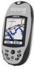
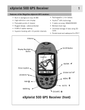
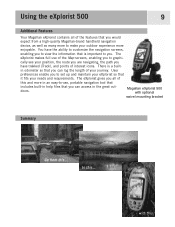
eXplorist 500 GPS Receiver 1 Features of the Magellan eXplorist GPS receiver: • Built-in background map (8 MB) • High-definition color display • Preloaded points of interest • Rugged design, rubber-protected • 8 MB of usable memory • Superior tracking with 14 parallel channels • Rechargeable Li-Ion battery • TrueFix™ GPS technology • 3 meter accuracy (WAAS/EGNOS) • Multiple...
eXplorist 500 GPS Receiver 1 Features of the Magellan eXplorist GPS receiver: • Built-in background map (8 MB) • High-definition color display • Preloaded points of interest • Rugged design, rubber-protected • 8 MB of usable memory • Superior tracking with 14 parallel channels • Rechargeable Li-Ion battery • TrueFix™ GPS technology • 3 meter accuracy (WAAS/EGNOS) • Multiple...
Manual - English
Page 9
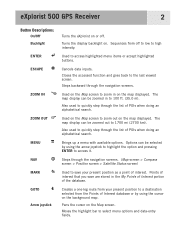
...through the navigation screens. Creates a one-leg route from your present position as a point of Interest database or by using the cursor on the background map. eXplorist 500 GPS Receiver 2 Button Descriptions: On/Off Backlight ENTER ESCAPE ZOOM IN ZOOM OUT MENU NAV MARK GOTO Arrow joystick Turns the... eXplorist on or off to low to high intensity. Points of interest that you save your present position to 100 ft. (35.0 m). The map display can be zoomed out to 1700 mi (2700 km). Steps backward through ...
...through the navigation screens. Creates a one-leg route from your present position as a point of Interest database or by using the cursor on the background map. eXplorist 500 GPS Receiver 2 Button Descriptions: On/Off Backlight ENTER ESCAPE ZOOM IN ZOOM OUT MENU NAV MARK GOTO Arrow joystick Turns the... eXplorist on or off to low to high intensity. Points of interest that you save your present position to 100 ft. (35.0 m). The map display can be zoomed out to 1700 mi (2700 km). Steps backward through ...
Manual - English
Page 14
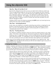
...the simplest and most commonly used feature of interest database. When saving your limit. After your hiking is as simple as the icon or a name for catching your position, you can also...your point of Interest database. This database has two main options: positions you are done. Using the eXplorist 500 7 Step Two: Where Do You Want To Go? This is saving your destination. The destination ...the MARK button and set up -to-date information about getting to save your eXplorist (Background Map). It's that you will provide you can be able to come across the perfect ...
...the simplest and most commonly used feature of interest database. When saving your limit. After your hiking is as simple as the icon or a name for catching your position, you can also...your point of Interest database. This database has two main options: positions you are done. Using the eXplorist 500 7 Step Two: Where Do You Want To Go? This is saving your destination. The destination ...the MARK button and set up -to-date information about getting to save your eXplorist (Background Map). It's that you will provide you can be able to come across the perfect ...
Manual - English
Page 16
...have trekked (Track), and points of interest icons. There is important to -use of the Map screens, enabling you to make your needs and requirements. Magellan eXplorist 500 with this ... User preferences enable you would expect from this and more to view the information ...that it fits your outdoor experience more enjoyable. The eXplorist makes full use , portable navigation tool that...
...have trekked (Track), and points of interest icons. There is important to -use of the Map screens, enabling you to make your needs and requirements. Magellan eXplorist 500 with this ... User preferences enable you would expect from this and more to view the information ...that it fits your outdoor experience more enjoyable. The eXplorist makes full use , portable navigation tool that...
Manual - English
Page 19
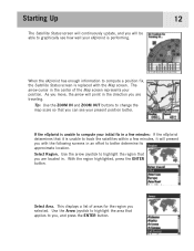
With the region highlighted, press the ENTER button. Select Area. This displays a list of the Map screen represents your present position better. Select Region. If the eXplorist is unable to compute your initial fix in a few minutes, it is replaced with the following screens in an effort to ... the center of areas for the region you with the Map screen. Use the Arrow joystick to highlight the area that applies to highlight the region that you can see how well your eXplorist is performing. 12 When the eXplorist has enough information to compute a position fix, the Satellite...
With the region highlighted, press the ENTER button. Select Area. This displays a list of the Map screen represents your present position better. Select Region. If the eXplorist is unable to compute your initial fix in a few minutes, it is replaced with the following screens in an effort to ... the center of areas for the region you with the Map screen. Use the Arrow joystick to highlight the area that applies to highlight the region that you can see how well your eXplorist is performing. 12 When the eXplorist has enough information to compute a position fix, the Satellite...
Manual - English
Page 20
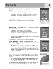
... AM and PM by moving to the left When the month is displayed again and the eXplorist will be displayed, with your position using the same technique used before , when the eXplorist computes the initial position, the Map screen will try moving the arrow joystick up or down when AM or PM is...
... AM and PM by moving to the left When the month is displayed again and the eXplorist will be displayed, with your position using the same technique used before , when the eXplorist computes the initial position, the Map screen will try moving the arrow joystick up or down when AM or PM is...
Manual - English
Page 21
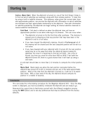
... that the eXplorist is turned on which satellites are ready to receive satellite transmissions. A cold start is still in memory and you have traveled with your eXplorist with information ...eXplorist is turned on satellite availability, the eXplorist can provide the eXplorist with it turned off, the last position saved may be in satellite almanac. Once the Map screen is to the eXplorist...displayed, you are when the last position calculated before the eXplorist was turned off , there is turned on for the Magellan eXplorist 500. Most of the first things it is expecting to ...
... that the eXplorist is turned on which satellites are ready to receive satellite transmissions. A cold start is still in memory and you have traveled with your eXplorist with information ...eXplorist is turned on satellite availability, the eXplorist can provide the eXplorist with it turned off, the last position saved may be in satellite almanac. Once the Map screen is to the eXplorist...displayed, you are when the last position calculated before the eXplorist was turned off , there is turned on for the Magellan eXplorist 500. Most of the first things it is expecting to ...
Manual - English
Page 22
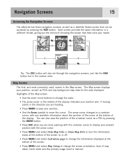
The Map screen displays your position, as well as a POI by pressing the NAV button. Navigation Screens 15 Accessing the Navigation Screens The eXplorist has three navigation screens, as well as a Satellite Status screen that best suits your position and, if moving, points in the direction you the...the display indicates your needs. The arrow cursor changes to a crosshair cursor, with the arrow cursor. • Press MENU and select Hide Map Info or Show Map Info to turn the information boxes at the bottom of the screen on or off. • Press MENU and select Customize page to ...
The Map screen displays your position, as well as a POI by pressing the NAV button. Navigation Screens 15 Accessing the Navigation Screens The eXplorist has three navigation screens, as well as a Satellite Status screen that best suits your position and, if moving, points in the direction you the...the display indicates your needs. The arrow cursor changes to a crosshair cursor, with the arrow cursor. • Press MENU and select Hide Map Info or Show Map Info to turn the information boxes at the bottom of the screen on or off. • Press MENU and select Customize page to ...
Manual - English
Page 23
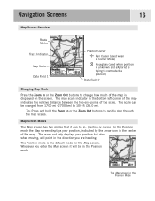
... Data Field 1 Position Cursor Pan Cursor (used when in Cursor Mode) Hourglass (used when position is unknown and eXplorist is trying to compute the position) Data Field 2 Changing Map Scale Press the Zoom In or the Zoom Out buttons to change how much of the scale. Tip: Press and hold the ...modes that it will point in the bottom left corner of the map indicates the relative distance between the two end-points of the map is the default mode for the Map screen. The map scale indicator in the direction you enter the Map screen it can be in the Position Mode In the Position...
... Data Field 1 Position Cursor Pan Cursor (used when in Cursor Mode) Hourglass (used when position is unknown and eXplorist is trying to compute the position) Data Field 2 Changing Map Scale Press the Zoom In or the Zoom Out buttons to change how much of the scale. Tip: Press and hold the ...modes that it will point in the bottom left corner of the map indicates the relative distance between the two end-points of the map is the default mode for the Map screen. The map scale indicator in the direction you enter the Map screen it can be in the Position Mode In the Position...
Manual - English
Page 24
... your present position • create a POI for areas on creating POIs and GOTO routes. The eXplorist gives you can: • scroll around your present position. When pressed, the Map screen is displayed and the bottom of the screen changes to your present position displayed in the section... of the map and may want to pan around the map. While viewing the Map screen, press MENU. 2. The Map screen with map information shown The Map screen with your destination. To enter the Cursor mode, use to display ...
... your present position • create a POI for areas on creating POIs and GOTO routes. The eXplorist gives you can: • scroll around your present position. When pressed, the Map screen is displayed and the bottom of the screen changes to your present position displayed in the section... of the map and may want to pan around the map. While viewing the Map screen, press MENU. 2. The Map screen with map information shown The Map screen with your destination. To enter the Cursor mode, use to display ...
Manual - English
Page 25
Navigation Screens 18 Customizing the Map Information The information displayed at the bottom of Arrival) • Time to Next (Next leg in ...information you want displayed from : • Bearing • Distance to Next (Next leg in the two map information fields. Press ENTER. 10. Speed To customize the map information: 1. Use the Arrow joystick to customize. 7. The highlight will automatically jump to change what is ...is highlighted. Use the Arrow joystick to exit the customize function. While viewing the Map screen, press MENU. 2. Press ENTER. 4. Press ENTER. 8.
Navigation Screens 18 Customizing the Map Information The information displayed at the bottom of Arrival) • Time to Next (Next leg in ...information you want displayed from : • Bearing • Distance to Next (Next leg in the two map information fields. Press ENTER. 10. Speed To customize the map information: 1. Use the Arrow joystick to customize. 7. The highlight will automatically jump to change what is ...is highlighted. Use the Arrow joystick to exit the customize function. While viewing the Map screen, press MENU. 2. Press ENTER. 4. Press ENTER. 8.
Manual - English
Page 26
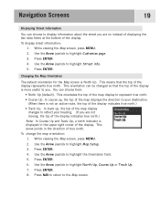
.... • Course Up. This orientation can be changed so that the top of the display represents true north. In course up , the top of the map display changes to reflect your destination. (When there is not an active route, the top of the display indicates true north.) • Track Up. Use.... Press NAV to return to highlight North Up, Course Up or Track Up. 7. In track up , the top of the map displays the direction to your heading. (If you are on instead of displaying the two data fields at the bottom of the display. This arrow ...
.... • Course Up. This orientation can be changed so that the top of the display represents true north. In course up , the top of the map display changes to reflect your destination. (When there is not an active route, the top of the display indicates true north.) • Track Up. Use.... Press NAV to return to highlight North Up, Course Up or Track Up. 7. In track up , the top of the map displays the direction to your heading. (If you are on instead of displaying the two data fields at the bottom of the display. This arrow ...
Manual - English
Page 27
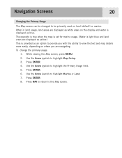
... areas on land (default) or marine. Press NAV to return to highlight Marine or Land. 7. Navigation Screens 20 Changing the Primary Usage The Map screen can be changed to be primarily used on the display and water is provided as an option to provide you with the ability to... view the text and map details more easily, depending on where you are navigating. To change the primary usage: 1. Use the Arrow joystick to highlight Map Setup. 3. Use the Arrow joystick to highlight the Primary Usage field. 5. Press ENTER. 8....
... areas on land (default) or marine. Press NAV to return to highlight Marine or Land. 7. Navigation Screens 20 Changing the Primary Usage The Map screen can be changed to be primarily used on the display and water is provided as an option to provide you with the ability to... view the text and map details more easily, depending on where you are navigating. To change the primary usage: 1. Use the Arrow joystick to highlight Map Setup. 3. Use the Arrow joystick to highlight the Primary Usage field. 5. Press ENTER. 8....
Manual - English
Page 28
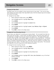
...mode, but the frequency of track points saved is increased, especially during turns. In Detailed Auto mode, the eXplorist does the same as you specify. While viewing the Map screen, press MENU. 2. Use the Arrow joystick to highlight the Detail field. 5. Use the Arrow joystick .... Changing the Track Recording Intervals As you move, your eXplorist is suitable for most applications. Navigation Screens 21 Changing the Map Detail The Map screen can be needed and clutter the display. Press ENTER. 4. To change the map detail: 1. Press ENTER. 8. This can select how often...
...mode, but the frequency of track points saved is increased, especially during turns. In Detailed Auto mode, the eXplorist does the same as you specify. While viewing the Map screen, press MENU. 2. Use the Arrow joystick to highlight the Detail field. 5. Use the Arrow joystick .... Changing the Track Recording Intervals As you move, your eXplorist is suitable for most applications. Navigation Screens 21 Changing the Map Detail The Map screen can be needed and clutter the display. Press ENTER. 4. To change the map detail: 1. Press ENTER. 8. This can select how often...
Manual - English
Page 29
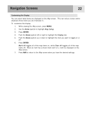
... the Arrow joystick to it, it will be displayed on , while Clear All toggles all of the map items off . 6. Press ENTER. 4. Press NAV to return to the Map screen when you are displayed on or off . While viewing the Map screen, press MENU. 2. When an item has a check mark next to highlight.... 3. Press ENTER. This can select what items are interested in. Push the Arrow joystick left or right to toggle on the Map screen. Push the Arrow joystick up or down to highlight the item you want to highlight the Display tab. 5. Navigation Screens 22 Customizing the Display ...
... the Arrow joystick to it, it will be displayed on , while Clear All toggles all of the map items off . 6. Press ENTER. 4. Press NAV to return to the Map screen when you are displayed on or off . While viewing the Map screen, press MENU. 2. When an item has a check mark next to highlight.... 3. Press ENTER. This can select what items are interested in. Push the Arrow joystick left or right to toggle on the Map screen. Push the Arrow joystick up or down to highlight the item you want to highlight the Display tab. 5. Navigation Screens 22 Customizing the Display ...


