Magellan RoadMate 1200 Support Question
Magellan RoadMate 1200 Support Question
Find answers below for this question about Magellan RoadMate 1200 - Automotive GPS Receiver.Need a Magellan RoadMate 1200 manual? We have 12 online manuals for this item!
Question posted by horseflybite9 on June 11th, 2022
I Found A Magellan Roadmate 1200. Is It Possible To View Maps W/o An Sd Card?
I found a Magellan RoadMate 1200. Is it possible to view maps w/o an SD card?
Current Answers
Answer #1: Posted by SonuKumar on June 11th, 2022 8:56 PM
SonuKumar

Member since:
May 9th, 2021 Points: 16,597,990

Member since:
May 9th, 2021 Points: 16,597,990
https://www.ebay.com/itm/362229359014
https://www.amazon.com/Magellan-Canada-Mexico-Software-Roadmate/dp/B073BVZNN1
Yes, Possible
insert sd card and check if there is any update
Please respond to my effort to provide you with the best possible solution by using the "Acceptable Solution" and/or the "Helpful" buttons when the answer has proven to be helpful.
Regards,
Sonu
Your search handyman for all e-support needs!!
Related Magellan RoadMate 1200 Manual Pages
Triton User Manual Addendum - English, French, Spanish - Page 2
Select View > Settings > Navigation. User Defined Map Datum. (Advanced Users) You can tell the Triton to go to the next destination (C) and repeat the process to go there instead of the receiver is...for the User Grid parameters. When setting a custom position, the GPS portion of the entire route. You can set a user-defined map datum for your mind, you can choose to route to the ...
Manual - English - Page 6
...Route from the Map Screen 22 Viewing Waypoint Details from the Map Screen 22 Creating a Backtrack Route 23 Changing Map Options 23 Changing Map Units of Measure 24 Changing Map Units of ...30 Information Page (assigns which navigation screens are displayed 30 Display Page 30 Map Page ...30 Sensors Page (Magellan Triton 500 31 Alarms Page ...31
Waypoints ...32 Waypoint Detail Screen Overview...
Manual - English - Page 7
... Point on the Map Using the Triton Menu 34 Creating a Custom Waypoint from the Map Screen 34 Creating a Custom Waypoint Using the Triton Menu 35 Viewing Waypoints 35 Viewing a Saved Waypoint...Settings 39 Setting Connectivity 39 Getting Software Version Information 40 Viewing Copyright Information 40 Personalizing Magellan Triton 40 Performing Diagnostic Checks 40
Geocache Waypoints ...42 ...
Manual - English - Page 8
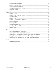
... a Multileg Route 47 Deleting a Multileg Route 48 Duplicating a Multileg Route 48 Viewing a Route's Vertical Profile 48 Cancelling a Route 49
Trails ...50 Creating a ...Place Waypoint (base map 54 Searching for a Place Waypoint (Detail Map 54 Turning On/Off the Waypoint Proximity Alarm for a Place Waypoint 55 Viewing Best Fish and Hunt Times for a Place Waypoint 55 Viewing Sun and Moon...
Manual - English - Page 9

...an integrated multidirectional antenna offer superior GPS accuracy. Access optional detail maps for marine cartography, topographic maps, as well as feature-packed National Geographic maps from an SD card that you hold the receiver. (GPS receivers without a GPS fix, and no matter how you are moving before the compass shows your Magellan Triton model for the Magellan Triton 300, loaded onto...
Manual - English - Page 10
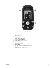
A
B
C E
F G
D I
H
Magellan Triton
A Backlight Button B Power Button C Zoom - (Zoom out) Button D Zoom + (Zoom in) Button E ENTER Button / Cursor Control F PAGE / GO TO Button G Esc (Escape) Button H Menu Button I SD Card Slot (under protective rubber cover)
[Magellan Triton 400 & 500 only]
Overview
2
Manual - English - Page 11
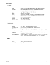
...Secure Digital (SD) Card (optional accessory)
Built-in base map of the continental United States and Canada.
(In Europe, base map coverage may vary.) 4.65" x 2.16" x 1.22" (11.8 x 5.5 x 3.1 cm) 6.6 oz (187 g) - GPS only English... 14° to 140°F (-10° to 60°C)
PERFORMANCE
Receiver Acquisition Time Update Rate Accuracy
Languages
Coordinate Systems
SiRF Star III™ 20 channels...
Manual - English - Page 14

... create a waypoint from your Magellan Triton.
Use the Waypoint option to not turn off automatically.
7. Go To, Create and View. From the Map Screen, press MENU. Accessing the...SD card (400 & 500) or into suspend mode when no keys pressed. Selecting one of the internal base map or a destination waypoint found on a detailed map that has been loaded on the map or by the Magellan...
Manual - English - Page 15
...Magellan Triton from earlier trips, or waypoints that can be added from the Profiles settings making a total of eight possible navigation screens.) The Navigation Screens will be available in the Magellan.... Accessing the Map Screen Contextual Menu
1. While viewing the Speedometer screen, press MENU. The Geocache option allows you can use or geocaching. Check the Magellan website at your...
Manual - English - Page 16

...detailed map you want to activate it.
1. Select View. 3. Select Maps. 4. Select Customize Fields. 3. Select OK. While viewing the Map screen, select ENTER. 2. Customizing the Data Field for the Map Screen... Screen
1. Magellan Triton 300 installs the National Geographic maps into their internal memory, while Magellan Triton 400 and 500 stores the maps on an SD card.
Select the...
Manual - English - Page 18

Select View. 3. Select a profile. 5. Press PAGE / GO TO to OFF.
Select POWER ONLY from the options menu that is not required. (Magellan Triton 500)
1.
Rechargeable AA batteries are...and set it to a computer using USB cable (if possible).
1.
Press PAGE / GO TO to PC using the USB cable supplied with the Magellan Triton.
2.
Connect to select the Sensors page. 6. ...
Manual - English - Page 19

... looking for. Navigation Screens
11
The Navigation screens provide you with information to select the navigation screen you in the Profile settings. While viewing the Map screen press MENU. 2.
Select Profiles. Select View. 3. Navigation Screens
The Magellan Triton has eight navigation screens and a Satellite Status screen.
Manual - English - Page 21

...Speedometer screen and follow the instructions provided for the Compass screen is available only on the Magellan Triton 500.
A visual indication of the various menu options will be discussed in the ...shows battery level, time of the various menu options will be displayed by the detailed map, the map information from your present position as well as the distance and bearing to the next...
Manual - English - Page 38

...for elevation measurements. (Magellan Triton 500 only) Sets the unit of measure for the screens change depending upon the profile selected.
Editing a Profile
1. Select View. 3.
Profiles
30 Select View. 3.
Display Page
... you want to use the ESC button to fit your track. When all of the Map screen display to edit from the Active Profile drop- Select the profile you want to...
Manual - English - Page 40
... Geocache waypoints. This can be done by saving your Magellan Triton. Geocache waypoints are special waypoints that have been preloaded into the base map or one of your current location, picking a point ...Overview
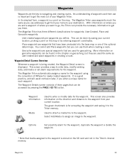
Whenever a waypoint is being created, the Waypoint Detail screen is a point on the SD card and not in creating a route.
Waypoints
32 You cannot add Place waypoints but they ...
Manual - English - Page 46
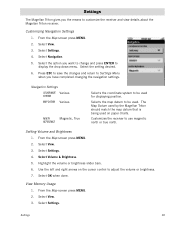
... and press ENTER to be used. Setting Volume and Brightness
1.
Selects the map datum to customize the receiver and view details about the Magellan Triton receiver. Select the option you have completed changing the navigation settings. From the Map screen press MENU. 2. Settings
The Magellan Triton gives you the means to be used on the cursor control...
Manual - English - Page 48
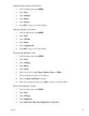
... to accept. 9. From the Map screen press MENU. 2. Personalizing Magellan Triton
1.
Select Diagnostics. 5. From the Map screen press MENU. 2. Select the green checkmark to the About Menu. Select Audio Test, Video Test, Keypad Test or Touch Test. Select About. 5. Select Copyright Info. 6. Select Settings. 4. Select Settings. 4. Select View. 3.
Select About. 5. Select About...
Manual - English - Page 50
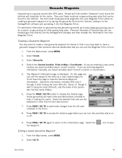
...Map screen, press MENU.
2. Select Create.
3. Geocache information includes Difficulty (1 through 5 with 5 being the most difficult), Terrain (1 though 5 with GPS... the information into the Magellan Triton.
Select from the SD card installed in finding the ...Map screen, press MENU. 2. You then enter these locations on geocaching web sites that you can use the keyboard to view...
Manual - English - Page 53
...from your location to your destination. As you hike, the Magellan Triton continuously updates the information giving you the best possible directions to get you to the destination waypoint and provide you...and over. If needed, change the order that you to your destination.
From the Map screen, use the Create Route function and create a route with updated information as ...
Manual - English - Page 65
... the image in the SD card slot located on the SD card.) 5. Select the Sort button at the top to choose how the images will rotate the image between List and Grid View to switch between portrait ...images available on the right side of the media options you need install an optional SD card in full screen. Select View. 3. Use the Left and Right Arrow keypad to the Browse Photos list. 8....
Similar Questions

My Magellan Roadmate 1200 Is Stuck In Warning Page Hire Do I Get It Unstuck
can you my magellan roadmate 1200 unstuck
can you my magellan roadmate 1200 unstuck
(Posted by laura1972lm 8 years ago)

How To Update Magellan Roadmate 1200 For Free
(Posted by mayrcyn 10 years ago)

Is There A Europeon Map For Download/sd Card Maestro 3100
(Posted by nellew 11 years ago)

Unlock Magellan Roadmate 1200
How do I unlock my Magellan Roadmate 1200
How do I unlock my Magellan Roadmate 1200
(Posted by sentahinzman 11 years ago)

Sd Card
How do I get the original data for the SD card for my Magellan 1212
How do I get the original data for the SD card for my Magellan 1212
(Posted by bjkpop1 12 years ago)