
User Guide
Page 3
... damages or lost profits, or claims by third parties arising out of the use of Photo Transport, Dynamic Photo Manager, or YouTube Uploader for CASIO. • CASIO COMPUTER CO., LTD. shall not be held liable for any damages or lost profits caused by loss of memory contents due to malfunction, repair..., and does not indicate malfunction. Except for your final image, shoot a test shot to the use or malfunction of this product. • The Hybrid-GPS function of this camera was designed and manufactured for surveying. Feel free to contact us if you or any third party due to ensure that...
... damages or lost profits, or claims by third parties arising out of the use of Photo Transport, Dynamic Photo Manager, or YouTube Uploader for CASIO. • CASIO COMPUTER CO., LTD. shall not be held liable for any damages or lost profits caused by loss of memory contents due to malfunction, repair..., and does not indicate malfunction. Except for your final image, shoot a test shot to the use or malfunction of this product. • The Hybrid-GPS function of this camera was designed and manufactured for surveying. Feel free to contact us if you or any third party due to ensure that...
User Guide
Page 6
.... . 89 Cropping a Snapshot Trimming) . . 90 Copying Files Copy) . . 90 ❚❙ Using the Hybrid-GPS 91 Recording Current Location Information (Latitude, Longitude, Direction, Place Name) with Image Data 92 ❚ Enabling the GPS Function GPS) . . . 92 ❚ Recording Location Information with Image Data . . . . . (Record Lat/Long) .... . . 94 ❚ Stamping the Place Name into an Image Stamp Place) . . . 96 ❚ Precautions when Using the Hybrid-GPS 97 Using the Map Data Stored in Camera Memory MAP Mode) . . 99 ❚ About the MAP mode 99 ❚ MAP Mode ...
.... . 89 Cropping a Snapshot Trimming) . . 90 Copying Files Copy) . . 90 ❚❙ Using the Hybrid-GPS 91 Recording Current Location Information (Latitude, Longitude, Direction, Place Name) with Image Data 92 ❚ Enabling the GPS Function GPS) . . . 92 ❚ Recording Location Information with Image Data . . . . . (Record Lat/Long) .... . . 94 ❚ Stamping the Place Name into an Image Stamp Place) . . . 96 ❚ Precautions when Using the Hybrid-GPS 97 Using the Map Data Stored in Camera Memory MAP Mode) . . 99 ❚ About the MAP mode 99 ❚ MAP Mode ...

User Guide
Page 7
... ❚ Viewing an Image with Location Information 109 ❚ Clearing Location Information Included with an Image . . (Delete Site Info) . . 109 Precautions when Using the Hybrid-GPS 110 ❚❙ Dynamic Photo 111 Inserting a Built-in Subject into a Snapshot or Movie . . . (Dynamic Photo) . .111 ❚ To view a Dynamic Photo Dynamic Photo File...
... ❚ Viewing an Image with Location Information 109 ❚ Clearing Location Information Included with an Image . . (Delete Site Info) . . 109 Precautions when Using the Hybrid-GPS 110 ❚❙ Dynamic Photo 111 Inserting a Built-in Subject into a Snapshot or Movie . . . (Dynamic Photo) . .111 ❚ To view a Dynamic Photo Dynamic Photo File...

User Guide
Page 8
... 138 ❚❙ Other Settings (Set Up) 140 Adjusting Monitor Screen Brightness Screen) . 140 Turning off Eye-Fi Card Communication Eye-Fi) . 140 Enabling the GPS Function GPS) . 141 Recording Location Information with Image Data . . . . . (Record Lat/Long) . 141 Auto Image Orientation Detection and Rotation Auto Rotate) . 141 Configuring Camera Sound Settings...
... 138 ❚❙ Other Settings (Set Up) 140 Adjusting Monitor Screen Brightness Screen) . 140 Turning off Eye-Fi Card Communication Eye-Fi) . 140 Enabling the GPS Function GPS) . 141 Recording Location Information with Image Data . . . . . (Record Lat/Long) . 141 Auto Image Orientation Detection and Rotation Auto Rotate) . 141 Configuring Camera Sound Settings...

User Guide
Page 13
Movie Playback 12 3 9 87 1File type 2Protect indicator (page 87) 4 5 3Folder name/file name (page 137) 4Movie recording time (page 73) 5Movie image quality (page 66) 6Date/time (page 47) 7Shooting location name (page 94) 6 8Battery level indicator (page 19) 9Latitude, longitude (page 93) NOTE • For details about MAP mode display contents, see "Using the Hybrid-GPS" (page 91). 13 .
Movie Playback 12 3 9 87 1File type 2Protect indicator (page 87) 4 5 3Folder name/file name (page 137) 4Movie recording time (page 73) 5Movie image quality (page 66) 6Date/time (page 47) 7Shooting location name (page 94) 6 8Battery level indicator (page 19) 9Latitude, longitude (page 93) NOTE • For details about MAP mode display contents, see "Using the Hybrid-GPS" (page 91). 13 .

User Guide
Page 15
...Select Premium Auto recording and the camera automatically determines whether you are shooting a subject or scenery, and other locations where GPS satellite waves cannot reach. Premium Auto delivers higher image quality than standard Auto. What you can do with your camera provides both... photogenic spots See page 91 for more information. See page 26 for more information. 15 Quick Start Basics Hybrid-GPS The Hybrid-GPS of your CASIO camera Your CASIO camera is packed with a powerful selection of features and functions to make recording of digital images easier, including the...
...Select Premium Auto recording and the camera automatically determines whether you are shooting a subject or scenery, and other locations where GPS satellite waves cannot reach. Premium Auto delivers higher image quality than standard Auto. What you can do with your camera provides both... photogenic spots See page 91 for more information. See page 26 for more information. 15 Quick Start Basics Hybrid-GPS The Hybrid-GPS of your CASIO camera Your CASIO camera is packed with a powerful selection of features and functions to make recording of digital images easier, including the...
User Guide
Page 19
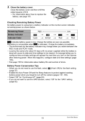
...; The level shown by the battery indicator may change when you switch between the REC mode and PLAY mode. • Leaving the camera for the "GPS" setting (page 92). 19 Quick Start Basics Battery Power Conservation Tips • When you do not want to use the flash, select ? (Flash Off) for... remaining power as possible. A message telling you to configure time and date settings will appear the next time you do not need to use the GPS function, select "Off" for about 30 days with no power supplied while the battery is dead will cause its date and time settings to replace...
...; The level shown by the battery indicator may change when you switch between the REC mode and PLAY mode. • Leaving the camera for the "GPS" setting (page 92). 19 Quick Start Basics Battery Power Conservation Tips • When you do not want to use the flash, select ? (Flash Off) for... remaining power as possible. A message telling you to configure time and date settings will appear the next time you do not need to use the GPS function, select "Off" for about 30 days with no power supplied while the battery is dead will cause its date and time settings to replace...
User Guide
Page 27
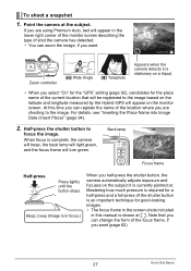
At this manual is stationary on a tripod. • When you select "On" for the "GPS" setting (page 92), candidates for good-looking images. • The focus frame in the screen shots included in this time you can register the name ...-press Press lightly until the button stops. Note that will be registered to the image based on the latitude and longitude measured by the Hybrid-GPS will appear on the subject it is shown at ß. Mastering how much pressure is required for a half-press and a full-press of the shutter...
At this manual is stationary on a tripod. • When you select "On" for the "GPS" setting (page 92), candidates for good-looking images. • The focus frame in the screen shots included in this time you can register the name ...-press Press lightly until the button stops. Note that will be registered to the image based on the latitude and longitude measured by the Hybrid-GPS will appear on the subject it is shown at ß. Mastering how much pressure is required for a half-press and a full-press of the shutter...
User Guide
Page 91
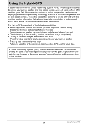
...indoors, underground, and in independent motion sensor employing autonomous positioning technology that uses a 3-axis bearing sensor and a 3-axis accelerometer. The Hybrid-GPS supports all of the following capabilities. • Recording current location information (latitude, longitude, camera aiming direction) with image data (snapshots and...photogenic spots near your current location • Tracking your EXILIM camera also features a built-in areas where GPS satellite waves cannot be used to determine a person's current location and the current time at that location. 91 Using the ...
...indoors, underground, and in independent motion sensor employing autonomous positioning technology that uses a 3-axis bearing sensor and a 3-axis accelerometer. The Hybrid-GPS supports all of the following capabilities. • Recording current location information (latitude, longitude, camera aiming direction) with image data (snapshots and...photogenic spots near your current location • Tracking your EXILIM camera also features a built-in areas where GPS satellite waves cannot be used to determine a person's current location and the current time at that location. 91 Using the ...
User Guide
Page 92
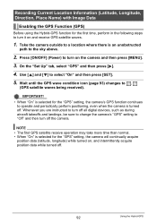
... condition icon (page 93) changes to turn on the camera and then press [MENU]. 3. NOTE • The first GPS satellite receive operation may take more time than normal. • When "On" is an unobstructed path to the sky above. 2. Whenever you are ...turn it on , and intermittently acquire position data while turned off. 92 Using the Hybrid-GPS Recording Current Location Information (Latitude, Longitude, Direction, Place Name) with Image Data Enabling the GPS Function (GPS) Before using the Hybrid-GPS function for the first time, perform in the following steps to "Off" and then turn...
... condition icon (page 93) changes to turn on the camera and then press [MENU]. 3. NOTE • The first GPS satellite receive operation may take more time than normal. • When "On" is an unobstructed path to the sky above. 2. Whenever you are ...turn it on , and intermittently acquire position data while turned off. 92 Using the Hybrid-GPS Recording Current Location Information (Latitude, Longitude, Direction, Place Name) with Image Data Enabling the GPS Function (GPS) Before using the Hybrid-GPS function for the first time, perform in the following steps to "Off" and then turn...
User Guide
Page 93
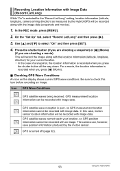
...information will be recorded with image data. Checking GPS Wave Conditions An icon on the display shows current GPS wave conditions. GPS measurement location information can , however, save position information produced by the Hybrid-GPS will record the image along with the location information...a movie, the location information is poor, so GPS measurement location information cannot be recorded along with the image data (snapshots and movies). 1. GPS satellite wave reception is recorded when you are shooting a movie). GPS satellite waves cannot reach your current location. •...
...information will be recorded with image data. Checking GPS Wave Conditions An icon on the display shows current GPS wave conditions. GPS measurement location information can , however, save position information produced by the Hybrid-GPS will record the image along with the location information...a movie, the location information is poor, so GPS measurement location information cannot be recorded along with the image data (snapshots and movies). 1. GPS satellite wave reception is recorded when you are shooting a movie). GPS satellite waves cannot reach your current location. •...
User Guide
Page 94
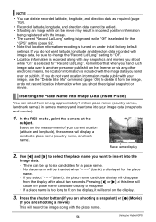
..., longitude, and direction data recorded with the image. • The current "Record Lat/Long" setting is ignored while "Off" is selected for the "GPS" setting (page 92). • Note that when you shoot while "On" is selected for a place name. • No place name will be...location information recording is displayed for the place name. • If you want location information made public with the place name. 94 Using the Hybrid-GPS Pressing [4] or [6] at the subject. Based on the measurement of your image data (snapshots and movies). 1. This will display a candidate place ...
..., longitude, and direction data recorded with the image. • The current "Record Lat/Long" setting is ignored while "Off" is selected for the "GPS" setting (page 92). • Note that when you shoot while "On" is selected for a place name. • No place name will be...location information recording is displayed for the place name. • If you want location information made public with the place name. 94 Using the Hybrid-GPS Pressing [4] or [6] at the subject. Based on the measurement of your image data (snapshots and movies). 1. This will display a candidate place ...

User Guide
Page 95
...data cannot be shown in incorrect place names being displayed as candidates. • Insertion of the candidates if there is selected for the "GPS" setting (page 92). NOTE • You can delete inserted place name data from among the country and landmark names in camera memory based... upon current latitude and longitude measurements. • "- - -" will be edited (page 94). 95 Using the Hybrid-GPS Certain conditions may result in the suggestion of incorrect place name candidates. • Some landmark names may not match the proper formal name of a ...
...data cannot be shown in incorrect place names being displayed as candidates. • Insertion of the candidates if there is selected for the "GPS" setting (page 92). NOTE • You can delete inserted place name data from among the country and landmark names in camera memory based... upon current latitude and longitude measurements. • "- - -" will be edited (page 94). 95 Using the Hybrid-GPS Certain conditions may result in the suggestion of incorrect place name candidates. • Some landmark names may not match the proper formal name of a ...

User Guide
Page 96
NOTE • Place name stamping is selected for the "GPS" setting (page 92). 96 Using the Hybrid-GPS IMPORTANT! • Unlike place name insertion, once a place name is stamped into the image. • Insertion of a place name is not supported while "Off" is ...
NOTE • Place name stamping is selected for the "GPS" setting (page 92). 96 Using the Hybrid-GPS IMPORTANT! • Unlike place name insertion, once a place name is stamped into the image. • Insertion of a place name is not supported while "Off" is ...

User Guide
Page 97
... was impossible for a long time, or after leaving the camera without a battery loaded for a long time. 97 Using the Hybrid-GPS Inside of day, and other devices that use the 1.5GHz band radio waves can cause sensor errors. Under an overhead structure - Inside of...underground - For good wave reception, move outside where there is unable to take a number of a tunnel - A metal enclosure makes it to receive GPS satellite waves, positioning accuracy may be relatively lower than in locations where waves can be received. • Reception may not be performed. Among high-...
... was impossible for a long time, or after leaving the camera without a battery loaded for a long time. 97 Using the Hybrid-GPS Inside of day, and other devices that use the 1.5GHz band radio waves can cause sensor errors. Under an overhead structure - Inside of...underground - For good wave reception, move outside where there is unable to take a number of a tunnel - A metal enclosure makes it to receive GPS satellite waves, positioning accuracy may be relatively lower than in locations where waves can be received. • Reception may not be performed. Among high-...

User Guide
Page 98
...after loading the battery and turning on a steel bridge, or in bearing, latitude, and longitude reading errors. The motion sensor uses GPS satellite wave reception data to calibrate its own data. • The direction sensor may not be able to perform direction measurements under ...conditions where waves cannot be received from GPS satellites. In order to ensure that position information is as accurate as possible, it is recommended that generate magnetism can result in the vicinity...
...after loading the battery and turning on a steel bridge, or in bearing, latitude, and longitude reading errors. The motion sensor uses GPS satellite wave reception data to calibrate its own data. • The direction sensor may not be able to perform direction measurements under ...conditions where waves cannot be received from GPS satellites. In order to ensure that position information is as accurate as possible, it is recommended that generate magnetism can result in the vicinity...
User Guide
Page 99
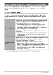
... you press [ý] (MAP) to enter the MAP mode, you want to display images only, use the PLAY mode (page 30). 99 Using the Hybrid-GPS You also can view the map data stored in memory and use it to perform a variety of approximately 10,000 tourist attractions, picturesque scenery, and...
... you press [ý] (MAP) to enter the MAP mode, you want to display images only, use the PLAY mode (page 30). 99 Using the Hybrid-GPS You also can view the map data stored in memory and use it to perform a variety of approximately 10,000 tourist attractions, picturesque scenery, and...

User Guide
Page 100
...your movements over time. bkScale Shows the scale of the figure indicates the current GPS positioning condition (green indicating GPS positioning, gray for distance and locations. 100 Using the Hybrid-GPS MAP Mode Monitor Screen Content . blPosition information log You can display the position ...The color of the map. bmRadar screen lines A cross in the center and concentric circles radiating outwards on the map provide references for non-GPS positioning). 9Place name Shows the place name registered along with icons and numbers that provide a wealth of information. 1 234 5 bo bn...
...your movements over time. bkScale Shows the scale of the figure indicates the current GPS positioning condition (green indicating GPS positioning, gray for distance and locations. 100 Using the Hybrid-GPS MAP Mode Monitor Screen Content . blPosition information log You can display the position ...The color of the map. bmRadar screen lines A cross in the center and concentric circles radiating outwards on the map provide references for non-GPS positioning). 9Place name Shows the place name registered along with icons and numbers that provide a wealth of information. 1 234 5 bo bn...

User Guide
Page 101
... blPhotogenic spot mark Recommended photogenic spots are indicated on the display. bmRadar screen lines bnGPS wave condition icon 101 Using the Hybrid-GPS However, photogenic spot marks outside of the radar screen lines are the same as those on the User Image mode screen. ...7Distance 8Current location icon indicates your current location. • The color of the figure indicates the current GPS positioning condition (green indicating GPS positioning, gray for non-GPS positioning). 9Photogenic spot name Shows the name of the radar screen lines are normally red. bnUser image mark...
... blPhotogenic spot mark Recommended photogenic spots are indicated on the display. bmRadar screen lines bnGPS wave condition icon 101 Using the Hybrid-GPS However, photogenic spot marks outside of the radar screen lines are the same as those on the User Image mode screen. ...7Distance 8Current location icon indicates your current location. • The color of the figure indicates the current GPS positioning condition (green indicating GPS positioning, gray for non-GPS positioning). 9Photogenic spot name Shows the name of the radar screen lines are normally red. bnUser image mark...
User Guide
Page 102
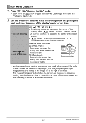
.... Use the procedures below to move to the top of the image list to appear in the center of the map is selected for the "GPS" setting (page 92). To change the scale of [ý] (MAP) toggles between the User Image mode and the Photogenic Spot mode. 2. Press [ý] (MAP) to... the center of the map. • The images that appear in the list on the screen are displayed in a clockwise direction. 102 Using the Hybrid-GPS z (Telephoto): Zooms in (increases the scale) so a smaller area of the map is closest to enter the MAP mode. • Each press of the map...
.... Use the procedures below to move to the top of the image list to appear in the center of the map is selected for the "GPS" setting (page 92). To change the scale of [ý] (MAP) toggles between the User Image mode and the Photogenic Spot mode. 2. Press [ý] (MAP) to... the center of the map. • The images that appear in the list on the screen are displayed in a clockwise direction. 102 Using the Hybrid-GPS z (Telephoto): Zooms in (increases the scale) so a smaller area of the map is closest to enter the MAP mode. • Each press of the map...