
Technical Reference for Garmin NMEA 2000 Products
Page 2
..., copied, transmitted, disseminated, downloaded or stored in any storage medium, for current updates and supplemental information concerning the use and operation of Garmin Ltd. Garmin®, the Garmin logo, and GPSMAP® are trademarks of this and other countries. NMEA 2000® and the ...8482;, GST™, GMI™, GRA™, GET™, GHC™, Intelliducer™, are registered trademarks of Garmin. Visit the Garmin Web site (www.garmin.com) for any revision hereto is subject to change or improve its products and to notify any unauthorized commercial ...
..., copied, transmitted, disseminated, downloaded or stored in any storage medium, for current updates and supplemental information concerning the use and operation of Garmin Ltd. Garmin®, the Garmin logo, and GPSMAP® are trademarks of this and other countries. NMEA 2000® and the ...8482;, GST™, GMI™, GRA™, GET™, GHC™, Intelliducer™, are registered trademarks of Garmin. Visit the Garmin Web site (www.garmin.com) for any revision hereto is subject to change or improve its products and to notify any unauthorized commercial ...

Technical Reference for Garmin NMEA 2000 Products
Page 17
... PGN List Group Function Product Information Vessel Heading Magnetic Variance Speed - These groups are organized into groups. All Garmin NMEA 2000 devices use the proprietary PGN numbers 126720 and 61184. NMEA 2000-Compatible Display Device PGN Information NMEA 2000...126992 System Time 126996 Product Information 127250 Vessel Heading 127489 Engine Parameters - Rapid Update 129026 COG & SOG - Rapid Update 127493 Transmission Parameters, Dynamic 127505 Fluid Level 128259 Speed - GPSMAP 6000/7000 Series Chartplotters Receive 059392 ISO Acknowledgment 059904 ISO Request 060928 ISO ...
... PGN List Group Function Product Information Vessel Heading Magnetic Variance Speed - These groups are organized into groups. All Garmin NMEA 2000 devices use the proprietary PGN numbers 126720 and 61184. NMEA 2000-Compatible Display Device PGN Information NMEA 2000...126992 System Time 126996 Product Information 127250 Vessel Heading 127489 Engine Parameters - Rapid Update 129026 COG & SOG - Rapid Update 127493 Transmission Parameters, Dynamic 127505 Fluid Level 128259 Speed - GPSMAP 6000/7000 Series Chartplotters Receive 059392 ISO Acknowledgment 059904 ISO Request 060928 ISO ...

Technical Reference for Garmin NMEA 2000 Products
Page 22
... Transmit/Receive PGN List Group Function System Time and Date Product Information Position - Rapid Update COG & SOG - Command/Request/Acknowledge Group Function GET 10 (Garmin Engine Tilt Adapter) Transmit 059392 ISO Acknowledgment 060928 ISO Address Claim 126208 NMEA - Dynamic... Engine Receive 059392 059904 060928 126208 127489 127497 127505 127505 Fluid Level (when calibrated using a Garmin chartplotter or marine instrument) GRA 10 (Garmin Rudder Angle Adapter) Transmit Receive 059392 ISO Acknowledgment 059392 060928 ISO Address Claim 059904 126208 NMEA -...
... Transmit/Receive PGN List Group Function System Time and Date Product Information Position - Rapid Update COG & SOG - Command/Request/Acknowledge Group Function GET 10 (Garmin Engine Tilt Adapter) Transmit 059392 ISO Acknowledgment 060928 ISO Address Claim 126208 NMEA - Dynamic... Engine Receive 059392 059904 060928 126208 127489 127497 127505 127505 Fluid Level (when calibrated using a Garmin chartplotter or marine instrument) GRA 10 (Garmin Rudder Angle Adapter) Transmit Receive 059392 ISO Acknowledgment 059392 060928 ISO Address Claim 059904 126208 NMEA -...

Technical Reference for Garmin NMEA 2000 Products
Page 23
... ISO Acknowledgment 059392 060928 ISO Address Claim 059904 126208 NMEA - Command/Request/Acknowledge Group Function GST 10 (Garmin Water Speed and Temperature Adapter) Transmit Receive 059392 ISO Acknowledgment 059392 ISO Acknowledgment 060928 ISO Address Claim 059904 ... Group Function 126208 NMEA - Command/Request/Acknowledge Group Function GFL 10 (Garmin Fluid Level Adapter) Transmit 059392 ISO Acknowledgment 060928 ISO Address Claim 126208 NMEA - Rapid Update Receive 126208 NMEA - Command/Request/Acknowledge Group Function 126996 Product Information 128259...
... ISO Acknowledgment 059392 060928 ISO Address Claim 059904 126208 NMEA - Command/Request/Acknowledge Group Function GST 10 (Garmin Water Speed and Temperature Adapter) Transmit Receive 059392 ISO Acknowledgment 059392 ISO Acknowledgment 060928 ISO Address Claim 059904 ... Group Function 126208 NMEA - Command/Request/Acknowledge Group Function GFL 10 (Garmin Fluid Level Adapter) Transmit 059392 ISO Acknowledgment 060928 ISO Address Claim 126208 NMEA - Rapid Update Receive 126208 NMEA - Command/Request/Acknowledge Group Function 126996 Product Information 128259...

Technical Reference for Garmin NMEA 2000 Products
Page 25
... Claim NMEA - North America Only) Transmit Receive 059392 060928 126208 126464 126996 ISO Acknowledgment ISO Address Claim NMEA - Rapid Update GNSS (Global Navigation Satellite System) Position Data VHF 300 Receive 059392 ISO Acknowledgment 059904 ISO Request 060928 ISO Address Claim 126208... Position Report AIS SAR Aircraft Position Report Radio Frequency/Mode/Power Radio Frequency/Mode/Power DSC Call Information Technical Reference for Garmin NMEA 2000 Products 21 Command/Request/Acknowledge Group Function 129026 COG (course over ground) and SOG (speed over ground) ...
... Claim NMEA - North America Only) Transmit Receive 059392 060928 126208 126464 126996 ISO Acknowledgment ISO Address Claim NMEA - Rapid Update GNSS (Global Navigation Satellite System) Position Data VHF 300 Receive 059392 ISO Acknowledgment 059904 ISO Request 060928 ISO Address Claim 126208... Position Report AIS SAR Aircraft Position Report Radio Frequency/Mode/Power Radio Frequency/Mode/Power DSC Call Information Technical Reference for Garmin NMEA 2000 Products 21 Command/Request/Acknowledge Group Function 129026 COG (course over ground) and SOG (speed over ground) ...

Technical Reference for Garmin NMEA 2000 Products
Page 27
...all custom configuration settings when you restore factory default settings. Setting the Speed Filter The speed filter setting on WAAS/EGNOS, visit www.garmin.com. 1. Select Config > Speed Filter. 3. While viewing the NMEA 2000 configuration menu, select the GPS 17x device. 2. ...Restoring Factory Default Settings You can restore factory default settings to provide smoother position data updates. Select Config > Factory Defaults. For more -accurate position information. Select Config > WAAS/EGNOS. 3. The speed filter averages the ...
...all custom configuration settings when you restore factory default settings. Setting the Speed Filter The speed filter setting on WAAS/EGNOS, visit www.garmin.com. 1. Select Config > Speed Filter. 3. While viewing the NMEA 2000 configuration menu, select the GPS 17x device. 2. ...Restoring Factory Default Settings You can restore factory default settings to provide smoother position data updates. Select Config > Factory Defaults. For more -accurate position information. Select Config > WAAS/EGNOS. 3. The speed filter averages the ...

Technical Reference for Garmin NMEA 2000 Products
Page 41
...). To configure the wind angle filter if the menu option is not displayed: 1. A lower filter setting shows changes in increments of software loaded on your Garmin marine instrument, the specific configuration options may stabilize the display. Enter the following command: "ANGLEFILTER=" 3. Follow the command with a number between 0 and 254,... following options to adjust the filter settings. • Off-the wind angle data is not filtered. • On-select a lower number to update the display device less often, and help the gauge needle or wind angle number to specify data for...
...). To configure the wind angle filter if the menu option is not displayed: 1. A lower filter setting shows changes in increments of software loaded on your Garmin marine instrument, the specific configuration options may stabilize the display. Enter the following command: "ANGLEFILTER=" 3. Follow the command with a number between 0 and 254,... following options to adjust the filter settings. • Off-the wind angle data is not filtered. • On-select a lower number to update the display device less often, and help the gauge needle or wind angle number to specify data for...

Technical Reference for Garmin NMEA 2000 Products
Page 42
... 2000 network? (page 7) Are all drop cables less than 20 ft. (6 m)? (page 8) For the latest free software updates (excluding map data) throughout the life of your NMEA 2000 installation. NMEA 2000 Checklist Use this checklist to confirm your Garmin products, visit the Garmin Web site at www.garmin.com. March 2012 © 2009-2012...
... 2000 network? (page 7) Are all drop cables less than 20 ft. (6 m)? (page 8) For the latest free software updates (excluding map data) throughout the life of your NMEA 2000 installation. NMEA 2000 Checklist Use this checklist to confirm your Garmin products, visit the Garmin Web site at www.garmin.com. March 2012 © 2009-2012...

Owners Manual
Page 2
Go to www.garmin.com for current updates and supplemental information concerning the use of such marks by the Bluetooth SIG, Inc. These trademarks may not be used without the written consent of ...; is a registered trademark of Microsoft Corporation in part, without the express permission of Sirius XM Radio Inc. All other countries. Garmin®, the Garmin logo, ActiveCaptain®, ANT®, BlueChart®, Fusion®, GPSMAP®, inReach®, Ultrascroll®, and VIRB® are trademarks of their respective owners. Under the copyright laws, this...
Go to www.garmin.com for current updates and supplemental information concerning the use of such marks by the Bluetooth SIG, Inc. These trademarks may not be used without the written consent of ...; is a registered trademark of Microsoft Corporation in part, without the express permission of Sirius XM Radio Inc. All other countries. Garmin®, the Garmin logo, ActiveCaptain®, ANT®, BlueChart®, Fusion®, GPSMAP®, inReach®, Ultrascroll®, and VIRB® are trademarks of their respective owners. Under the copyright laws, this...

Owners Manual
Page 3
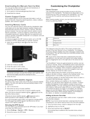
... 1 Tips and Shortcuts (MFD models 1 Accessing Owner's Manuals on the Chartplotter 1 Downloading the Manuals from the Web 2 Garmin Support Center 2 Inserting Memory Cards 2 Acquiring GPS Satellite Signals 2 Selecting the GPS Source 2 Customizing the Chartplotter 2 Home Screen... with the ActiveCaptain App 5 Enabling Smart Notifications 5 Receiving Notifications 6 Managing Notifications 6 Making Notifications Private 6 Updating Software with the ActiveCaptain App 6 Updating Charts with ActiveCaptain 6 Communication with Wireless Devices 6 Wi‑Fi Network 7 Setting Up the Wi‑...
... 1 Tips and Shortcuts (MFD models 1 Accessing Owner's Manuals on the Chartplotter 1 Downloading the Manuals from the Web 2 Garmin Support Center 2 Inserting Memory Cards 2 Acquiring GPS Satellite Signals 2 Selecting the GPS Source 2 Customizing the Chartplotter 2 Home Screen... with the ActiveCaptain App 5 Enabling Smart Notifications 5 Receiving Notifications 6 Managing Notifications 6 Making Notifications Private 6 Updating Software with the ActiveCaptain App 6 Updating Charts with ActiveCaptain 6 Communication with Wireless Devices 6 Wi‑Fi Network 7 Setting Up the Wi‑...
Owners Manual
Page 5
...Up and Following a Search Pattern 39 Cancelling a Steering Pattern 39 Adjusting the Autopilot Response 39 Enabling the Autopilot Controls on a Garmin Watch 39 Customizing the Autopilot Button Actions 39 Controlling the Autopilot with a GRID 20 Remote Control ........ 39 Reactor™ Autopilot ... a Reactor Autopilot Remote Control With a Chartplotter 40 Changing the Functions of the Reactor Autopilot Remote Control Action Keys 40 Updating the Reactor Autopilot Remote Control Software .. 40 Yamaha Autopilot 40 Yamaha Autopilot Screen 40 Yamaha Autopilot Settings 40 Yamaha Autopilot ...
...Up and Following a Search Pattern 39 Cancelling a Steering Pattern 39 Adjusting the Autopilot Response 39 Enabling the Autopilot Controls on a Garmin Watch 39 Customizing the Autopilot Button Actions 39 Controlling the Autopilot with a GRID 20 Remote Control ........ 39 Reactor™ Autopilot ... a Reactor Autopilot Remote Control With a Chartplotter 40 Changing the Functions of the Reactor Autopilot Remote Control Action Keys 40 Updating the Reactor Autopilot Remote Control Software .. 40 Yamaha Autopilot 40 Yamaha Autopilot Screen 40 Yamaha Autopilot Settings 40 Yamaha Autopilot ...
Owners Manual
Page 6
... Locked Channels on a SiriusXM Radio ....... 50 Restoring Default Parental Control Settings Values ....... 50 Changing a Parental Passcode on a SiriusXM Radio ..... 50 Setting the Device Name 51 Updating the Media Player Software 51 SiriusXM Weather 51 SiriusXM Equipment and Subscription Requirements 51 Weather Data Broadcasts 51 Weather Warnings and Weather Bulletins 51 Changing...
... Locked Channels on a SiriusXM Radio ....... 50 Restoring Default Parental Control Settings Values ....... 50 Changing a Parental Passcode on a SiriusXM Radio ..... 50 Setting the Device Name 51 Updating the Media Player Software 51 SiriusXM Weather 51 SiriusXM Equipment and Subscription Requirements 51 Weather Data Broadcasts 51 Weather Warnings and Weather Bulletins 51 Changing...

Owners Manual
Page 7
...Chartplotter 62 Saving System Information to a Memory Card 62 Appendix 62 Registering Your Device with Garmin Express 62 Software Update 62 Loading the New Software on a Memory Card 62 Updating the Device Software 62 Pairing the GRID Device with the Chartplotter from the Chartplotter 63 ...on or keeps turning off 63 My device is not creating waypoints in the correct location 64 Contacting Garmin Support 64 Specifications 64 GPSMAP 10x2 Specifications 64 GPSMAP 12x2 Specifications 64 Sonar Models Specifications 64 NMEA 2000 PGN Information 64 NMEA 0183 Information 65 Index 66...
...Chartplotter 62 Saving System Information to a Memory Card 62 Appendix 62 Registering Your Device with Garmin Express 62 Software Update 62 Loading the New Software on a Memory Card 62 Updating the Device Software 62 Pairing the GRID Device with the Chartplotter from the Chartplotter 63 ...on or keeps turning off 63 My device is not creating waypoints in the correct location 64 Contacting Garmin Support 64 Specifications 64 GPSMAP 10x2 Specifications 64 GPSMAP 12x2 Specifications 64 Sonar Models Specifications 64 NMEA 2000 PGN Information 64 NMEA 0183 Information 65 Index 66...
Owners Manual
Page 9
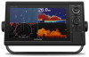
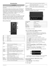
...Press to move the cursor. Press to pan on an option indicates the option is a GPSMAP 1212xsv model. 12-PIN XDCR* POWER CVBS IN ETHERNET NMEA 2000 12-pin transducer Power Ground... screw Composite video in a menu. There is also contact information to Garmin support should you can be precisely followed. Hold for one second to mark an SOS location,... highlight to zoom in the product box for a page. This can download software and chart updates. Introduction WARNING See the Important Safety and Product Information guide in or out of a view...
...Press to move the cursor. Press to pan on an option indicates the option is a GPSMAP 1212xsv model. 12-PIN XDCR* POWER CVBS IN ETHERNET NMEA 2000 12-pin transducer Power Ground... screw Composite video in a menu. There is also contact information to Garmin support should you can be precisely followed. Hold for one second to mark an SOS location,... highlight to zoom in the product box for a page. This can download software and chart updates. Introduction WARNING See the Important Safety and Product Information guide in or out of a view...
Owners Manual
Page 10
...question mark appears over on the front of the chartplotter. For help and information, such as product manuals, frequently asked questions, videos, software updates, and customer support. TIP: If your preferred source for GPS data. Speed class 4 or greater required. 1 Open the access flap ...page different on all displays in the station can show the radar screen. NOTE: If your chartplotter. The selected item is accessible only from the Garmin website. 1 Go to Favorites You can use the ActiveCaptain® app. For more than one GPS source. 1 Select Settings > System >...
...question mark appears over on the front of the chartplotter. For help and information, such as product manuals, frequently asked questions, videos, software updates, and customer support. TIP: If your preferred source for GPS data. Speed class 4 or greater required. 1 Open the access flap ...page different on all displays in the station can show the radar screen. NOTE: If your chartplotter. The selected item is accessible only from the Garmin website. 1 Go to Favorites You can use the ActiveCaptain® app. For more than one GPS source. 1 Select Settings > System >...
Owners Manual
Page 12
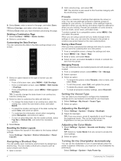
.... 2 Select a preset. 3 Select an option: • To rename the preset, select Rename, enter a name, and select Done. • To edit the preset, select Edit, and update the preset. • To delete the preset, select Delete. • To reset all presets to screens such as charts, sonar views, and radar views. You...
.... 2 Select a preset. 3 Select an option: • To rename the preset, select Rename, enter a name, and select Done. • To edit the preset, select Edit, and update the preset. • To delete the preset, select Delete. • To reset all presets to screens such as charts, sonar views, and radar views. You...

Owners Manual
Page 13
...61). ActiveCaptain App 5 You can transfer the user data back to the card (Copying User Data to the Garmin Quickdraw Contours Community, and update device software. Garmin makes no representations about the accuracy, completeness, or timeliness of interaction with Chartplotter. 5 Follow the on-screen... 6 digits. 3 Reenter the PIN to your GPSMAP device and complete such tasks as waypoints. It is recommended, but not required. NOTICE You might be prompted to account Update software Yes Yes Automatically transfer Garmin Quickdraw contours you forget the PIN. Formatting the ...
...61). ActiveCaptain App 5 You can transfer the user data back to the card (Copying User Data to the Garmin Quickdraw Contours Community, and update device software. Garmin makes no representations about the accuracy, completeness, or timeliness of interaction with Chartplotter. 5 Follow the on-screen... 6 digits. 3 Reenter the PIN to your GPSMAP device and complete such tasks as waypoints. It is recommended, but not required. NOTICE You might be prompted to account Update software Yes Yes Automatically transfer Garmin Quickdraw contours you forget the PIN. Formatting the ...

Owners Manual
Page 14
... for fishing, but allow notifications on the chartplotter used at the helm. 1 From the chartplotter you reconnect the app to the GPSMAP device, the update is available, and you have internet access on the type of notification and your phone operating system. • To answer a ... and your mobile device, space on your Internet service provider for your mobile device, select Clear. The Garmin Express app downloads large charts more information, go to garmin.com /express. Receiving Notifications WARNING Do not read or reply to notifications while operating the vessel. Failure ...
... for fishing, but allow notifications on the chartplotter used at the helm. 1 From the chartplotter you reconnect the app to the GPSMAP device, the update is available, and you have internet access on the type of notification and your phone operating system. • To answer a ... and your mobile device, space on your Internet service provider for your mobile device, select Clear. The Garmin Express app downloads large charts more information, go to garmin.com /express. Receiving Notifications WARNING Do not read or reply to notifications while operating the vessel. Failure ...
Owners Manual
Page 33
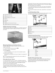
... and select a view. SideVü Scanning Technology Instead of a more like live movement either what is in front of or below your boat. The screen updates very quickly, producing sonar views that look more common conical beam, the SideVü transducer uses a flat beam to scan the water and bottom to...your bait underwater and bait schools in front of or below the boat and can be used to see a bait ball and fish. The screen updates with each sweep of the pin, select Set Reference. TIP: To reset the pin and measure from the current location of the transducer. Panoptix ...
... and select a view. SideVü Scanning Technology Instead of a more like live movement either what is in front of or below your boat. The screen updates very quickly, producing sonar views that look more common conical beam, the SideVü transducer uses a flat beam to scan the water and bottom to...your bait underwater and bait schools in front of or below the boat and can be used to see a bait ball and fish. The screen updates with each sweep of the pin, select Set Reference. TIP: To reset the pin and measure from the current location of the transducer. Panoptix ...
Owners Manual
Page 34
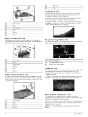
If you are connecting a transducer that was not included with a range of accessory transducers, including the Garmin ClearVü™ transducers, which are available at garmin.com/transducers. To see this feature. NOTE: Not all chartplotters and sonar modules support this sonar view, you must install and ... awareness by showing obstructions under the water, up to 91 meters (300 feet) in front of the boat. You may need to update the transducer software. To see fish and structures. Depth information Suspended targets or fish Bottom of the body of water Perspective View This...
If you are connecting a transducer that was not included with a range of accessory transducers, including the Garmin ClearVü™ transducers, which are available at garmin.com/transducers. To see this feature. NOTE: Not all chartplotters and sonar modules support this sonar view, you must install and ... awareness by showing obstructions under the water, up to 91 meters (300 feet) in front of the boat. You may need to update the transducer software. To see fish and structures. Depth information Suspended targets or fish Bottom of the body of water Perspective View This...
