
Technical Reference for Garmin NMEA 2000 Products
Page 2
...reproduced, copied, transmitted, disseminated, downloaded or stored in the USA and other Garmin products. All rights reserved. or its subsidiaries, registered in any storage medium, for current updates and supplemental information concerning the use and operation of this and other countries. ...GST™, GMI™, GRA™, GET™, GHC™, Intelliducer™, are trademarks of Garmin Ltd. Garmin®, the Garmin logo, and GPSMAP® are trademarks of Garmin Ltd. or its products and to make changes in the content without the express prior written consent ...
...reproduced, copied, transmitted, disseminated, downloaded or stored in the USA and other Garmin products. All rights reserved. or its subsidiaries, registered in any storage medium, for current updates and supplemental information concerning the use and operation of this and other countries. ...GST™, GMI™, GRA™, GET™, GHC™, Intelliducer™, are trademarks of Garmin Ltd. Garmin®, the Garmin logo, and GPSMAP® are trademarks of Garmin Ltd. or its products and to make changes in the content without the express prior written consent ...

Technical Reference for Garmin NMEA 2000 Products
Page 17
...AIS Class B Extended position report 129539 GNSS DOPs 129540 GNSS Sats in View Wind Data Temperature Technical Reference for Garmin NMEA 2000 Products 13 Rapid Update GNSS Position Data Cross Track Error Navigation Data Navigation Route/Waypoint Info GNSS Sats in View 129794 AIS Class A... NMEA 2000 network are identified by a Parameter Group Number (PGN) that describes the type of data contained in the group. GPSMAP 6000/7000 Series Chartplotters Receive 059392 ISO Acknowledgment 059904 ISO Request 060928 ISO Address Claim 126208 NMEA - Command/Request/Acknowledge Group Function...
...AIS Class B Extended position report 129539 GNSS DOPs 129540 GNSS Sats in View Wind Data Temperature Technical Reference for Garmin NMEA 2000 Products 13 Rapid Update GNSS Position Data Cross Track Error Navigation Data Navigation Route/Waypoint Info GNSS Sats in View 129794 AIS Class A... NMEA 2000 network are identified by a Parameter Group Number (PGN) that describes the type of data contained in the group. GPSMAP 6000/7000 Series Chartplotters Receive 059392 ISO Acknowledgment 059904 ISO Request 060928 ISO Address Claim 126208 NMEA - Command/Request/Acknowledge Group Function...

Technical Reference for Garmin NMEA 2000 Products
Page 22
... NMEA - NMEA 2000-Certified Sensor PGN Information NMEA 2000-Certified Sensor PGN Information The following tables list the non-proprietary PGN information for Garmin NMEA 2000 Products Rapid Update COG & SOG - Command/Request/Acknowledge Group Function 060928 126464 Transmit/Receive PGN List Group Function 126208 126996 Product Information 127245 Rudder ISO Acknowledgment...
... NMEA - NMEA 2000-Certified Sensor PGN Information NMEA 2000-Certified Sensor PGN Information The following tables list the non-proprietary PGN information for Garmin NMEA 2000 Products Rapid Update COG & SOG - Command/Request/Acknowledge Group Function 060928 126464 Transmit/Receive PGN List Group Function 126208 126996 Product Information 127245 Rudder ISO Acknowledgment...

Technical Reference for Garmin NMEA 2000 Products
Page 23
...ISO Address Claim 126464 Transmit/Receive PGN List Group Function 126208 NMEA - Command/Request/Acknowledge Group Function GBT 10 (Garmin Bennett Trim Tab Adapter) Transmit Receive 059392 ISO Acknowledgment 059392 060928 ISO Address Claim 059904 126208 NMEA - Command/...126996 127488 Transmit/Receive PGN List Group Function Product Information Engine Parameters - Rapid Update Receive 126208 NMEA - Command/Request/Acknowledge Group Function GST 10 (Garmin Water Speed and Temperature Adapter) Transmit Receive 059392 ISO Acknowledgment 059392 ISO Acknowledgment ...
...ISO Address Claim 126464 Transmit/Receive PGN List Group Function 126208 NMEA - Command/Request/Acknowledge Group Function GBT 10 (Garmin Bennett Trim Tab Adapter) Transmit Receive 059392 ISO Acknowledgment 059392 060928 ISO Address Claim 059904 126208 NMEA - Command/...126996 127488 Transmit/Receive PGN List Group Function Product Information Engine Parameters - Rapid Update Receive 126208 NMEA - Command/Request/Acknowledge Group Function GST 10 (Garmin Water Speed and Temperature Adapter) Transmit Receive 059392 ISO Acknowledgment 059392 ISO Acknowledgment ...

Technical Reference for Garmin NMEA 2000 Products
Page 25
... Weather and Radio - Command/Request/Acknowledge Group Function 129026 COG (course over ground) and SOG (speed over ground) - Rapid Update 129029 GNSS (Global Navigation Satellite System) Position Data 129039 AIS Class B Position Report 129794 AIS Class A Static and Voyage Related Data.../Power Radio Frequency/Mode/Power DSC Call Information Technical Reference for Garmin NMEA 2000 Products 21 Command/Request/Acknowledge Group Function COG (course over ground) and SOG (speed over ground) - Rapid Update GNSS (Global Navigation Satellite System) Position Data VHF 300 Receive...
... Weather and Radio - Command/Request/Acknowledge Group Function 129026 COG (course over ground) and SOG (speed over ground) - Rapid Update 129029 GNSS (Global Navigation Satellite System) Position Data 129039 AIS Class B Position Report 129794 AIS Class A Static and Voyage Related Data.../Power Radio Frequency/Mode/Power DSC Call Information Technical Reference for Garmin NMEA 2000 Products 21 Command/Request/Acknowledge Group Function COG (course over ground) and SOG (speed over ground) - Rapid Update GNSS (Global Navigation Satellite System) Position Data VHF 300 Receive...

Technical Reference for Garmin NMEA 2000 Products
Page 27
... 17x device. 2. Restoring Factory Default Settings You can restore factory default settings to provide smoother position data updates. Select Config > Factory Defaults. On a Garmin chartplotter, select On or Off. Select the interval at which the position information is most helpful when stationary...documentation provided with your NMEA 2000 display device. NMEA 2000-Certified Sensor Configuration Information NMEA 2000-Certified Sensor Configuration Information Garmin NMEA 2000-certified sensors each have moved the boat many miles without using the GPS 17x, for example, you ...
... 17x device. 2. Restoring Factory Default Settings You can restore factory default settings to provide smoother position data updates. Select Config > Factory Defaults. On a Garmin chartplotter, select On or Off. Select the interval at which the position information is most helpful when stationary...documentation provided with your NMEA 2000 display device. NMEA 2000-Certified Sensor Configuration Information NMEA 2000-Certified Sensor Configuration Information Garmin NMEA 2000-certified sensors each have moved the boat many miles without using the GPS 17x, for example, you ...

Technical Reference for Garmin NMEA 2000 Products
Page 41
... to adjust the filter settings. • Off-the wind angle data is not filtered. • On-select a lower number to update the display device less often, and help the gauge needle or wind angle number to represent the Automatic setting (for example: SPEEDFILTER=215..., representing a time constant in the wind angle. Technical Reference for example: ANGLEOFFSET=180). A lower filter setting shows changes in degrees (for Garmin NMEA 2000 Products 37 To configure the wind angle filter: 1. Select Generic Configuration to represent the Automatic setting (for the filter and offset settings...
... to adjust the filter settings. • Off-the wind angle data is not filtered. • On-select a lower number to update the display device less often, and help the gauge needle or wind angle number to represent the Automatic setting (for example: SPEEDFILTER=215..., representing a time constant in the wind angle. Technical Reference for example: ANGLEOFFSET=180). A lower filter setting shows changes in degrees (for Garmin NMEA 2000 Products 37 To configure the wind angle filter: 1. Select Generic Configuration to represent the Automatic setting (for the filter and offset settings...

Technical Reference for Garmin NMEA 2000 Products
Page 42
...Olathe, Kansas 66062, USA Garmin (Europe) Ltd. Is the NMEA 2000 network connected to power, and is the power balanced correctly on both ends of the NMEA 2000 network? (page 7) Are all drop cables less than 20 ft. (6 m)? (page 8) For the latest free software updates (excluding map data) throughout... the life of your NMEA 2000 installation. Is the bare wire connected to confirm your Garmin products, visit the Garmin Web site at www...
...Olathe, Kansas 66062, USA Garmin (Europe) Ltd. Is the NMEA 2000 network connected to power, and is the power balanced correctly on both ends of the NMEA 2000 network? (page 7) Are all drop cables less than 20 ft. (6 m)? (page 8) For the latest free software updates (excluding map data) throughout... the life of your NMEA 2000 installation. Is the bare wire connected to confirm your Garmin products, visit the Garmin Web site at www...

Owners Manual
Page 2
...® are trademarks of the YAMAHA Motor Co., LTD. Garmin®, the Garmin logo, ActiveCaptain®, ANT®, BlueChart®, Fusion®, GPSMAP®, inReach®, Ultrascroll®, and VIRB® are trademarks of Garmin Ltd. ActiveCaptain®, Apollo™, Connect IQ™, ECHOMAP...174;, and the NMEA 2000 logo are trademarks of Garmin. © 2019 Garmin Ltd. Apple® and Mac® are registered trademarks of FLIR Systems, Inc. Garmin reserves the right to www.garmin.com for current updates and supplemental information concerning the use of this manual...
...® are trademarks of the YAMAHA Motor Co., LTD. Garmin®, the Garmin logo, ActiveCaptain®, ANT®, BlueChart®, Fusion®, GPSMAP®, inReach®, Ultrascroll®, and VIRB® are trademarks of Garmin Ltd. ActiveCaptain®, Apollo™, Connect IQ™, ECHOMAP...174;, and the NMEA 2000 logo are trademarks of Garmin. © 2019 Garmin Ltd. Apple® and Mac® are registered trademarks of FLIR Systems, Inc. Garmin reserves the right to www.garmin.com for current updates and supplemental information concerning the use of this manual...

Owners Manual
Page 3
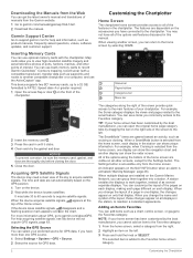
... 1 Tips and Shortcuts (MFD models 1 Accessing Owner's Manuals on the Chartplotter 1 Downloading the Manuals from the Web 2 Garmin Support Center 2 Inserting Memory Cards 2 Acquiring GPS Satellite Signals 2 Selecting the GPS Source 2 Customizing the Chartplotter 2 Home Screen... with the ActiveCaptain App 5 Enabling Smart Notifications 5 Receiving Notifications 6 Managing Notifications 6 Making Notifications Private 6 Updating Software with the ActiveCaptain App 6 Updating Charts with ActiveCaptain 6 Communication with Wireless Devices 6 Wi‑Fi Network 7 Setting Up the Wi‑...
... 1 Tips and Shortcuts (MFD models 1 Accessing Owner's Manuals on the Chartplotter 1 Downloading the Manuals from the Web 2 Garmin Support Center 2 Inserting Memory Cards 2 Acquiring GPS Satellite Signals 2 Selecting the GPS Source 2 Customizing the Chartplotter 2 Home Screen... with the ActiveCaptain App 5 Enabling Smart Notifications 5 Receiving Notifications 6 Managing Notifications 6 Making Notifications Private 6 Updating Software with the ActiveCaptain App 6 Updating Charts with ActiveCaptain 6 Communication with Wireless Devices 6 Wi‑Fi Network 7 Setting Up the Wi‑...
Owners Manual
Page 5
...Up and Following a Search Pattern 39 Cancelling a Steering Pattern 39 Adjusting the Autopilot Response 39 Enabling the Autopilot Controls on a Garmin Watch 39 Customizing the Autopilot Button Actions 39 Controlling the Autopilot with a GRID 20 Remote Control ........ 39 Reactor™ Autopilot ... a Reactor Autopilot Remote Control With a Chartplotter 40 Changing the Functions of the Reactor Autopilot Remote Control Action Keys 40 Updating the Reactor Autopilot Remote Control Software .. 40 Yamaha Autopilot 40 Yamaha Autopilot Screen 40 Yamaha Autopilot Settings 40 Yamaha Autopilot ...
...Up and Following a Search Pattern 39 Cancelling a Steering Pattern 39 Adjusting the Autopilot Response 39 Enabling the Autopilot Controls on a Garmin Watch 39 Customizing the Autopilot Button Actions 39 Controlling the Autopilot with a GRID 20 Remote Control ........ 39 Reactor™ Autopilot ... a Reactor Autopilot Remote Control With a Chartplotter 40 Changing the Functions of the Reactor Autopilot Remote Control Action Keys 40 Updating the Reactor Autopilot Remote Control Software .. 40 Yamaha Autopilot 40 Yamaha Autopilot Screen 40 Yamaha Autopilot Settings 40 Yamaha Autopilot ...
Owners Manual
Page 6
... Locked Channels on a SiriusXM Radio ....... 50 Restoring Default Parental Control Settings Values ....... 50 Changing a Parental Passcode on a SiriusXM Radio ..... 50 Setting the Device Name 51 Updating the Media Player Software 51 SiriusXM Weather 51 SiriusXM Equipment and Subscription Requirements 51 Weather Data Broadcasts 51 Weather Warnings and Weather Bulletins 51 Changing...
... Locked Channels on a SiriusXM Radio ....... 50 Restoring Default Parental Control Settings Values ....... 50 Changing a Parental Passcode on a SiriusXM Radio ..... 50 Setting the Device Name 51 Updating the Media Player Software 51 SiriusXM Weather 51 SiriusXM Equipment and Subscription Requirements 51 Weather Data Broadcasts 51 Weather Warnings and Weather Bulletins 51 Changing...

Owners Manual
Page 7
...Chartplotter 62 Saving System Information to a Memory Card 62 Appendix 62 Registering Your Device with Garmin Express 62 Software Update 62 Loading the New Software on a Memory Card 62 Updating the Device Software 62 Pairing the GRID Device with the Chartplotter from the Chartplotter 63 ...on or keeps turning off 63 My device is not creating waypoints in the correct location 64 Contacting Garmin Support 64 Specifications 64 GPSMAP 10x2 Specifications 64 GPSMAP 12x2 Specifications 64 Sonar Models Specifications 64 NMEA 2000 PGN Information 64 NMEA 0183 Information 65 Index 66...
...Chartplotter 62 Saving System Information to a Memory Card 62 Appendix 62 Registering Your Device with Garmin Express 62 Software Update 62 Loading the New Software on a Memory Card 62 Updating the Device Software 62 Pairing the GRID Device with the Chartplotter from the Chartplotter 63 ...on or keeps turning off 63 My device is not creating waypoints in the correct location 64 Contacting Garmin Support 64 Specifications 64 GPSMAP 10x2 Specifications 64 GPSMAP 12x2 Specifications 64 Sonar Models Specifications 64 NMEA 2000 PGN Information 64 NMEA 0183 Information 65 Index 66...
Owners Manual
Page 9
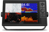
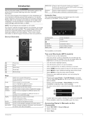
... all features are not intended to be helpful when the brightness is also contact information to Garmin support should you can be precisely followed. Press to return to select a highlighted option....a view. Press to display navigation information, such as a waypoint. This can download software and chart updates. Turn to zoom in vessel damage, personal injury, or death. A green light on the chartplotter...menu. All route and navigation lines displayed on an option indicates the option is a GPSMAP 1212xsv model. 12-PIN XDCR* POWER CVBS IN ETHERNET NMEA 2000 12-pin transducer...
... all features are not intended to be helpful when the brightness is also contact information to Garmin support should you can be precisely followed. Press to return to select a highlighted option....a view. Press to display navigation information, such as a waypoint. This can download software and chart updates. Turn to zoom in vessel damage, personal injury, or death. A green light on the chartplotter...menu. All route and navigation lines displayed on an option indicates the option is a GPSMAP 1212xsv model. 12-PIN XDCR* POWER CVBS IN ETHERNET NMEA 2000 12-pin transducer...
Owners Manual
Page 10
... memory cards with a compatible transducer), transfer data such as cruising or docking. Adding an Item to Favorites You can return to record Garmin Quickdraw™ Contours mapping, record sonar (with the chartplotter. When viewing another compatible chartplotter or a computer, and use blank memory cards... to the home screen by the boat manufacturer, you can add items such as product manuals, frequently asked questions, videos, software updates, and customer support. This device supports two SD® memory cards, up to a 32 GB, formatted to acquire satellite signals. ...
... memory cards with a compatible transducer), transfer data such as cruising or docking. Adding an Item to Favorites You can return to record Garmin Quickdraw™ Contours mapping, record sonar (with the chartplotter. When viewing another compatible chartplotter or a computer, and use blank memory cards... to the home screen by the boat manufacturer, you can add items such as product manuals, frequently asked questions, videos, software updates, and customer support. This device supports two SD® memory cards, up to a 32 GB, formatted to acquire satellite signals. ...
Owners Manual
Page 12
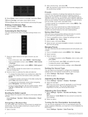
.... 2 Select a preset. 3 Select an option: • To rename the preset, select Rename, enter a name, and select Done. • To edit the preset, select Edit, and update the preset. • To delete the preset, select Delete. • To reset all presets to factory settings, select Reset All. Deleting a Combination Page 1 Select Combos...
.... 2 Select a preset. 3 Select an option: • To rename the preset, select Rename, enter a name, and select Done. • To edit the preset, select Edit, and update the preset. • To delete the preset, select Delete. • To reset all presets to factory settings, select Reset All. Deleting a Combination Page 1 Select Combos...

Owners Manual
Page 13
...is removed and reapplied within less than two minutes, you may need to press to the GPSMAP device using the ActiveCaptain app. You can download, purchase, and update maps and charts. Garmin makes no representations about the accuracy, completeness, or timeliness of your own risk. The ... the Screen Lock feature which notifications you receive in maps, and supplemental map Yes No cards to account Update software Yes Yes Automatically transfer Garmin Quickdraw contours you Yes No have downloaded or created Feature Push smart notifications Automatically transfer user data, such...
...is removed and reapplied within less than two minutes, you may need to press to the GPSMAP device using the ActiveCaptain app. You can download, purchase, and update maps and charts. Garmin makes no representations about the accuracy, completeness, or timeliness of your own risk. The ... the Screen Lock feature which notifications you receive in maps, and supplemental map Yes No cards to account Update software Yes Yes Automatically transfer Garmin Quickdraw contours you Yes No have downloaded or created Feature Push smart notifications Automatically transfer user data, such...

Owners Manual
Page 14
... on your internet service provider apply. The Garmin Express app downloads large charts more information about data limits or charges. NOTICE Chart updates may require the app to use . Before you are prompted by the GPSMAP device, select an option to your internet service...8209;Fi technology, you need. The ActiveCaptain app downloads the update to garmin.com /express. Contact your mobile device and enable the Smart Notifications feature (Enabling Smart Notifications, page 5). The phone call on the GPSMAP screen briefly. Regular data limits or charges from the mobile...
... on your internet service provider apply. The Garmin Express app downloads large charts more information about data limits or charges. NOTICE Chart updates may require the app to use . Before you are prompted by the GPSMAP device, select an option to your internet service...8209;Fi technology, you need. The ActiveCaptain app downloads the update to garmin.com /express. Contact your mobile device and enable the Smart Notifications feature (Enabling Smart Notifications, page 5). The phone call on the GPSMAP screen briefly. Regular data limits or charges from the mobile...
Owners Manual
Page 33
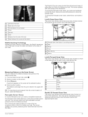
...can be used to see a bait ball and fish. To access the Panoptix sonar views, select Sonar, and select a view. The screen updates very quickly, producing sonar views that look more common conical beam, the SideVü transducer uses a flat beam to scan the water and ...the SideVü sonar view. 1 From the SideVü sonar view, select . 2 Select a location on the screen. 3 Select Measure. The screen updates with each sweep of or below your boat. SideVü Scanning Technology Instead of a more like live movement either what is below your bait underwater...
...can be used to see a bait ball and fish. To access the Panoptix sonar views, select Sonar, and select a view. The screen updates very quickly, producing sonar views that look more common conical beam, the SideVü transducer uses a flat beam to scan the water and ...the SideVü sonar view. 1 From the SideVü sonar view, select . 2 Select a location on the screen. 3 Select Measure. The screen updates with each sweep of or below your boat. SideVü Scanning Technology Instead of a more like live movement either what is below your bait underwater...
Owners Manual
Page 34
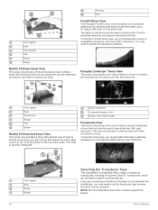
...-12970-00). Color legend Boat Range Bottom 26 Selecting the Transducer Type This chartplotter is compatible with a range of accessory transducers, including the Garmin ClearVü™ transducers, which are stationary and want to see what is around and ahead of your boat as you are connecting a transducer... shows a three-dimensional view of what is below the boat and can be used to see fish and structures. You may need to update the transducer software. Depth information Suspended targets or fish Bottom of the body of water Perspective View This sonar view shows a live view ...
...-12970-00). Color legend Boat Range Bottom 26 Selecting the Transducer Type This chartplotter is compatible with a range of accessory transducers, including the Garmin ClearVü™ transducers, which are stationary and want to see what is around and ahead of your boat as you are connecting a transducer... shows a three-dimensional view of what is below the boat and can be used to see fish and structures. You may need to update the transducer software. Depth information Suspended targets or fish Bottom of the body of water Perspective View This sonar view shows a live view ...
