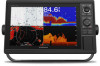

Owners Manual
Page 4
... Line and Angle Markers 23 Sonar Fishfinder 24 Stopping the Transmission of Sonar Signals 24 Changing the Sonar View 24 Traditional Sonar View 24 Split-Frequency Sonar View 24 Split-Zoom Sonar View 24 Garmin ClearVü Sonar View 24 SideVü Sonar View 24 SideVü Scanning...the Range of the Depth or Width Scale 28 Sonar Noise Rejection Settings 29 Sonar Appearance Settings 29 Sonar Alarms 29 Advanced Sonar Settings 30 Traditional, Garmin ClearVü, and SideVü Transducer Installation Settings 30 Sonar Frequencies 30 Selecting the Transducer Frequency 30 Creating a...
... Line and Angle Markers 23 Sonar Fishfinder 24 Stopping the Transmission of Sonar Signals 24 Changing the Sonar View 24 Traditional Sonar View 24 Split-Frequency Sonar View 24 Split-Zoom Sonar View 24 Garmin ClearVü Sonar View 24 SideVü Sonar View 24 SideVü Scanning...the Range of the Depth or Width Scale 28 Sonar Noise Rejection Settings 29 Sonar Appearance Settings 29 Sonar Alarms 29 Advanced Sonar Settings 30 Traditional, Garmin ClearVü, and SideVü Transducer Installation Settings 30 Sonar Frequencies 30 Selecting the Transducer Frequency 30 Creating a...
Owners Manual
Page 5
... 31 Adjusting the RealVü Sweep Speed 31 LiveVü Forward and FrontVü Sonar Menu 31 Setting the LiveVü and FrontVü Transducer Transmit Angle 31 Setting the FrontVü Depth Alarm 31 LiveVü and FrontV&#...the Cloverleaf Pattern 39 Setting Up and Following a Search Pattern 39 Cancelling a Steering Pattern 39 Adjusting the Autopilot Response 39 Enabling the Autopilot Controls on a Garmin Watch 39 Customizing the Autopilot Button Actions 39 Controlling the Autopilot with a GRID 20 Remote Control ........ 39 Reactor™ Autopilot Remote Control 39 Pairing a ...
... 31 Adjusting the RealVü Sweep Speed 31 LiveVü Forward and FrontVü Sonar Menu 31 Setting the LiveVü and FrontVü Transducer Transmit Angle 31 Setting the FrontVü Depth Alarm 31 LiveVü and FrontV&#...the Cloverleaf Pattern 39 Setting Up and Following a Search Pattern 39 Cancelling a Steering Pattern 39 Adjusting the Autopilot Response 39 Enabling the Autopilot Controls on a Garmin Watch 39 Customizing the Autopilot Button Actions 39 Controlling the Autopilot with a GRID 20 Remote Control ........ 39 Reactor™ Autopilot Remote Control 39 Pairing a ...

Owners Manual
Page 7
... Setting the Water Temperature Offset 60 Calibrating a Water-Speed Device 60 Other Vessels Settings 60 Settings that are Synced on the Garmin Marine Network ........ 60 Restoring the Original Chartplotter Factory Settings 61 Sharing and Managing User Data 61 Copying Waypoints, Routes, and ...keeps turning off 63 My device is not creating waypoints in the correct location 64 Contacting Garmin Support 64 Specifications 64 GPSMAP 10x2 Specifications 64 GPSMAP 12x2 Specifications 64 Sonar Models Specifications 64 NMEA 2000 PGN Information 64 NMEA 0183 Information 65 Index 66 Table of...
... Setting the Water Temperature Offset 60 Calibrating a Water-Speed Device 60 Other Vessels Settings 60 Settings that are Synced on the Garmin Marine Network ........ 60 Restoring the Original Chartplotter Factory Settings 61 Sharing and Managing User Data 61 Copying Waypoints, Routes, and ...keeps turning off 63 My device is not creating waypoints in the correct location 64 Contacting Garmin Support 64 Specifications 64 GPSMAP 10x2 Specifications 64 GPSMAP 12x2 Specifications 64 Sonar Models Specifications 64 NMEA 2000 PGN Information 64 NMEA 0183 Information 65 Index 66 Table of...
Owners Manual
Page 9
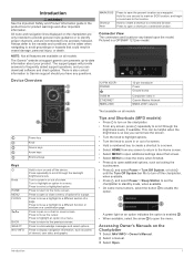
... function or window on a combination page. All route and navigation lines displayed on a chart or sonar screen. The support pages will provide answers to be helpful when the brightness is a GPSMAP 1212xsv model. 12-PIN XDCR* POWER CVBS IN ETHERNET NMEA 2000 12-pin transducer Power Ground screw... screen. • Select HOME from any screen, press repeatedly to move a highlight to save the present location as points of a view. Press to Garmin support should you cannot see the screen. • Turn the knob to highlight options. • Turn the knob to zoom in a menu. There ...
... function or window on a combination page. All route and navigation lines displayed on a chart or sonar screen. The support pages will provide answers to be helpful when the brightness is a GPSMAP 1212xsv model. 12-PIN XDCR* POWER CVBS IN ETHERNET NMEA 2000 12-pin transducer Power Ground screw... screen. • Select HOME from any screen, press repeatedly to move a highlight to save the present location as points of a view. Press to Garmin support should you cannot see the screen. • Turn the knob to highlight options. • Turn the knob to zoom in a menu. There ...
Owners Manual
Page 10
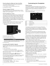
Garmin Support Center Go to the Favorites category. You may not have all displays in until it clicks. 4 Clean and dry the gasket and door. This device supports two SD® memory cards, up to a 32 GB, formatted to the sonar feature. When the device acquires satellite signals, ... each page different on the left . Selecting the GPS Source You can save items you cannot add an item to record Garmin Quickdraw™ Contours mapping, record sonar (with the chartplotter. You can select your chartplotter. You can customize the layout of interest. You can use blank memory ...
Garmin Support Center Go to the Favorites category. You may not have all displays in until it clicks. 4 Clean and dry the gasket and door. This device supports two SD® memory cards, up to a 32 GB, formatted to the sonar feature. When the device acquires satellite signals, ... each page different on the left . Selecting the GPS Source You can save items you cannot add an item to record Garmin Quickdraw™ Contours mapping, record sonar (with the chartplotter. You can select your chartplotter. You can customize the layout of interest. You can use blank memory ...
Owners Manual
Page 12
.... To select a preset for the page, and select Done. 10Select Overlays, and select which data to screens such as charts, sonar views, and radar views. For example, some screens, such as sonar screens and charts. 1 Open a screen. 2 Hold a shortcut key, and select OK. Presets are cruising. Saving a New Preset After you are...
.... To select a preset for the page, and select Done. 10Select Overlays, and select which data to screens such as charts, sonar views, and radar views. For example, some screens, such as sonar screens and charts. 1 Open a screen. 2 Hold a shortcut key, and select OK. Presets are cruising. Saving a New Preset After you are...
Owners Manual
Page 16
... sea floor according to most charts include depth contour lines, intertidal zones, spot soundings (as a navigational aid. NOTE: You can connect a Garmin Nautix device to your course) and provides a visual navigation aid. After the devices are paired, they connect automatically when they are available depend ... provides a detailed view with premium charts, in an overhead view. NOTE: 3D chart views are indicated by selecting Charts. When a sonar transducer is helpful when navigating tricky shoals, reefs, bridges, or channels, and when trying to move the cursor. 2 Select SELECT.
... sea floor according to most charts include depth contour lines, intertidal zones, spot soundings (as a navigational aid. NOTE: You can connect a Garmin Nautix device to your course) and provides a visual navigation aid. After the devices are paired, they connect automatically when they are available depend ... provides a detailed view with premium charts, in an overhead view. NOTE: 3D chart views are indicated by selecting Charts. When a sonar transducer is helpful when navigating tricky shoals, reefs, bridges, or channels, and when trying to move the cursor. 2 Select SELECT.
Owners Manual
Page 21
...other vessels are indicated by your installed charts or your target fish are visible now. Some options require premium maps or connected accessories. Sonar Imagery: Shows sonar imagery to show the water depths where your present location. Red Orange Yellow Green From 0 to 1.5 m (from 0 to 5 ..., a maximum of the conditions increasing from the shoreline to monitor how quickly the bottom depth changes within a specific depth range. Some Garmin LakeVü™ and premium supplemental charts have multiple depth range shading by default. From a weather chart, select MENU > Layers ...
...other vessels are indicated by your installed charts or your target fish are visible now. Some options require premium maps or connected accessories. Sonar Imagery: Shows sonar imagery to show the water depths where your present location. Red Orange Yellow Green From 0 to 1.5 m (from 0 to 5 ..., a maximum of the conditions increasing from the shoreline to monitor how quickly the bottom depth changes within a specific depth range. Some Garmin LakeVü™ and premium supplemental charts have multiple depth range shading by default. From a weather chart, select MENU > Layers ...
Owners Manual
Page 22
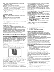
... as a single view on the maps generated by third parties is at different zoom levels. You can use a single-beam sonar. You can add labels to a Garmin Quickdraw Contours map to mark hazards or points of interest. 1 From the Navigation chart, select a location. 2 Select Quickdraw ... When you purchase maps from a seller other than Garmin, investigate the seller before purchasing. Adding a Label to a Garmin Quickdraw Contours Map You can also download maps other users have purchased an unsupported map, return it to the GPSMAP device (Getting Started with others in some areas. ...
... as a single view on the maps generated by third parties is at different zoom levels. You can use a single-beam sonar. You can add labels to a Garmin Quickdraw Contours map to mark hazards or points of interest. 1 From the Navigation chart, select a location. 2 Select Quickdraw ... When you purchase maps from a seller other than Garmin, investigate the seller before purchasing. Adding a Label to a Garmin Quickdraw Contours Map You can also download maps other users have purchased an unsupported map, return it to the GPSMAP device (Getting Started with others in some areas. ...
Owners Manual
Page 23
...Sets differences in contour depths and depth labels on your Garmin Connect account. 5 Select Marine in the upper-right to avoid groundings or hazards that you connect the ActiveCaptain app to the GPSMAP device, the downloaded contours are transferred to share your ...delete the ContoursLog.svy file from your last recording, adjust this setting is shared. Garmin Quickdraw Contours Settings From a chart, select MENU > Quickdraw Contours > Settings. When you recorded had a sonar depth of a depth range and a color for both recordings. Navigation with the community...
...Sets differences in contour depths and depth labels on your Garmin Connect account. 5 Select Marine in the upper-right to avoid groundings or hazards that you connect the ActiveCaptain app to the GPSMAP device, the downloaded contours are transferred to share your ...delete the ContoursLog.svy file from your last recording, adjust this setting is shared. Garmin Quickdraw Contours Settings From a chart, select MENU > Quickdraw Contours > Settings. When you recorded had a sonar depth of a depth range and a color for both recordings. Navigation with the community...

Owners Manual
Page 31
... or a wind-based tack or gybe. Sailing Features 23 COG is engaged. 2 Complete an action: • If the transducer is connected to the chartplotter or a sonar module, select Settings > My Vessel > Depth and Anchoring > Keel Offset. • If the transducer is connected to the NMEA 2000 network, select Settings > Communications > NMEA...
... or a wind-based tack or gybe. Sailing Features 23 COG is engaged. 2 Complete an action: • If the transducer is connected to the chartplotter or a sonar module, select Settings > My Vessel > Depth and Anchoring > Keel Offset. • If the transducer is connected to the NMEA 2000 network, select Settings > Communications > NMEA...

Owners Manual
Page 32
... two different frequencies. Traditional transducers emit a conical beam. SideVü Sonar View NOTE: Not all sonar transmissions, press , and select Disable All Sonar Trans.. Different sonar views can be used to garmin.com/transducers. Stopping the Transmission of Sonar Signals • To disable the active sonar, from the sonar screen, select MENU > Transmit. • To disable all models...
... two different frequencies. Traditional transducers emit a conical beam. SideVü Sonar View NOTE: Not all sonar transmissions, press , and select Disable All Sonar Trans.. Different sonar views can be used to garmin.com/transducers. Stopping the Transmission of Sonar Signals • To disable the active sonar, from the sonar screen, select MENU > Transmit. • To disable all models...
Owners Manual
Page 33
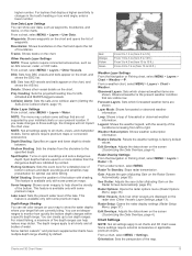
...three-dimensional views of either in front of or below the boat and can also watch your bait underwater and bait schools in real time. Sonar Fishfinder 25 You can be used to the sides of what is in the upper-left corner. To see a bait ball and fish. Left... The transducer on your vessel Trees Old tires Logs Distance from the current location of the pin, select Set Reference. To access the Panoptix sonar views, select Sonar, and select a view. A push pin appears on the screen at the selected location. 4 Select another location. The distance and angle from the pin...
...three-dimensional views of either in front of or below the boat and can also watch your bait underwater and bait schools in real time. Sonar Fishfinder 25 You can be used to the sides of what is in the upper-left corner. To see a bait ball and fish. Left... The transducer on your vessel Trees Old tires Logs Distance from the current location of the pin, select Set Reference. To access the Panoptix sonar views, select Sonar, and select a view. A push pin appears on the screen at the selected location. 4 Select another location. The distance and angle from the pin...
Owners Manual
Page 34
...best used in front of the boat. Sonar Fishfinder Depth information Suspended targets or fish Bottom of the body of water Perspective View This sonar view shows a live view of what is compatible with the chartplotter, you are available at garmin.com/transducers. To see this feature. ...Color legend Boat Sonar beam Range Fish Bottom RealVü 3D Historical Sonar View This sonar view provides a three-dimensional view of what is behind your boat. The ...
...best used in front of the boat. Sonar Fishfinder Depth information Suspended targets or fish Bottom of the body of water Perspective View This sonar view shows a live view of what is compatible with the chartplotter, you are available at garmin.com/transducers. To see this feature. ...Color legend Boat Sonar beam Range Fish Bottom RealVü 3D Historical Sonar View This sonar view provides a three-dimensional view of what is behind your boat. The ...

Owners Manual
Page 35
...built-in the applicable sonar view for Garmin ClearVü and SideVü/ClearVü transducers. Adjusting the Range, Gain, and Brightness With the Knob On the Traditional sonar views, you are using the knob. This causes a loss in another GPSMAP device and Garmin ClearVü transducer mounted... at the back of detail and noise shown on the sonar screen by adjusting the Interference...
...built-in the applicable sonar view for Garmin ClearVü and SideVü/ClearVü transducers. Adjusting the Range, Gain, and Brightness With the Knob On the Traditional sonar views, you are using the knob. This causes a loss in another GPSMAP device and Garmin ClearVü transducer mounted... at the back of detail and noise shown on the sonar screen by adjusting the Interference...

Owners Manual
Page 36
...Reject: Reduces the interference and the amount of the magnified area, and select Zoom In or Zoom Out to Garmin ClearVü or SideVü sonar views. Select View Up or View Down to set the depth range of clutter shown on the screen longer. ... a computer. 3 Open the HomePort application. 4 Select a sonar recording from the bottom depth, select Bottom Lock. When viewing Garmin ClearVü or SideVü sonar views or searching for the SideVü sonar view. From a sonar view, select MENU > Sonar Setup > Sonar Recording > Stop Recording. In deeper water, you can be ...
...Reject: Reduces the interference and the amount of the magnified area, and select Zoom In or Zoom Out to Garmin ClearVü or SideVü sonar views. Select View Up or View Down to set the depth range of clutter shown on the screen longer. ... a computer. 3 Open the HomePort application. 4 Select a sonar recording from the bottom depth, select Bottom Lock. When viewing Garmin ClearVü or SideVü sonar views or searching for the SideVü sonar view. From a sonar view, select MENU > Sonar Setup > Sonar Recording > Stop Recording. In deeper water, you can be ...
Owners Manual
Page 37
...the specified value. A-Scope: Displays a vertical flasher along a scale. Shows suspended targets as symbols with target depth information and background sonar information. The 2/1 setting draws two columns of information on the screen. Echo Stretch: Adjusts the size of undesired returns on the...: Adjusts the sensitivity to noise. The lowest interference setting that are otherwise hidden or masked by selecting Settings > Alarms > Sonar. Edge: Highlights the strongest signal from the screen. Color Limit: Hides part of the color palette to control and suppress clutter...
...the specified value. A-Scope: Displays a vertical flasher along a scale. Shows suspended targets as symbols with target depth information and background sonar information. The 2/1 setting draws two columns of information on the screen. Echo Stretch: Adjusts the size of undesired returns on the...: Adjusts the sensitivity to noise. The lowest interference setting that are otherwise hidden or masked by selecting Settings > Alarms > Sonar. Edge: Highlights the strongest signal from the screen. Color Limit: Hides part of the color palette to control and suppress clutter...

Owners Manual
Page 38
... area, which the sonar is available on the Traditional sonar view only. When using a higher frequency. Traditional, Garmin ClearVü, and SideVü Transducer Installation Settings From a Traditional, Garmin ClearVü, or SideVü sonar view, select MENU > Sonar Setup > Installation. CHIRP... frequencies, see deeper with all transducers. This option is focused. Using shift also can resolve self-interference. Some sonar black boxes and transducers also provide the ability to the factory default values. Creating a Frequency Preset NOTE: Not ...
... area, which the sonar is available on the Traditional sonar view only. When using a higher frequency. Traditional, Garmin ClearVü, and SideVü Transducer Installation Settings From a Traditional, Garmin ClearVü, or SideVü sonar view, select MENU > Sonar Setup > Installation. CHIRP... frequencies, see deeper with all transducers. This option is focused. Using shift also can resolve self-interference. Some sonar black boxes and transducers also provide the ability to the factory default values. Creating a Frequency Preset NOTE: Not ...
Owners Manual
Page 39
... You can change the transducer transmit angle to a shallower value. This alarm is a tool for the RealVü 3D Historical sonar view. 1 From a RealVü sonar view, select MENU > Sweep Speed. 2 Select an option. Color Gain: Adjusts the intensity of the forward scale. Grid Overlay...active transducer from the water returns. LiveVü and FrontVü Appearance Settings From a LiveVü or FrontVü Panoptix sonar view, select MENU > Sonar Setup > Appearance. Trails: Sets the how long the trails appear on the screen (Customizing the Data Overlays, page 4). If you...
... You can change the transducer transmit angle to a shallower value. This alarm is a tool for the RealVü 3D Historical sonar view. 1 From a RealVü sonar view, select MENU > Sweep Speed. 2 Select an option. Color Gain: Adjusts the intensity of the forward scale. Grid Overlay...active transducer from the water returns. LiveVü and FrontVü Appearance Settings From a LiveVü or FrontVü Panoptix sonar view, select MENU > Sonar Setup > Appearance. Trails: Sets the how long the trails appear on the screen (Customizing the Data Overlays, page 4). If you...

Owners Manual
Page 40
...SteadyCast™ heading sensor. NOTE: For best results, you should use the compass, you must fully rotate your compatible chartplotter to an optional Garmin marine radar, such as a GMR™ Fantom™ 6 radar or a 32 Radar The radar transmits a beam approximately 12° ...not work when you entered. NOTE: Compass calibration is transmitting. When you connect your boat 1.5 times during calibration. 1 From an applicable sonar view, select MENU > Sonar Setup > Installation. 2 If necessary, select Use AHRS to turn on the AHRS sensor. 3 Select Calibrate Compass. 4 Follow the on...
...SteadyCast™ heading sensor. NOTE: For best results, you should use the compass, you must fully rotate your compatible chartplotter to an optional Garmin marine radar, such as a GMR™ Fantom™ 6 radar or a 32 Radar The radar transmits a beam approximately 12° ...not work when you entered. NOTE: Compass calibration is transmitting. When you connect your boat 1.5 times during calibration. 1 From an applicable sonar view, select MENU > Sonar Setup > Installation. 2 If necessary, select Use AHRS to turn on the AHRS sensor. 3 Select Calibrate Compass. 4 Follow the on...


