
Important Safety and Product Information
Page 2
... local in a residential installation. Official government charts and notices to mariners contain all information needed to repair or replace your vessel. Operating or watching the video input while the vessel is the property of Garmin and/or its maximum output power mode and when used parts that satisfy Garmin's quality standards, (ii) replace the device with Garmin authorized accessories. Use of such devices...
... local in a residential installation. Official government charts and notices to mariners contain all information needed to repair or replace your vessel. Operating or watching the video input while the vessel is the property of Garmin and/or its maximum output power mode and when used parts that satisfy Garmin's quality standards, (ii) replace the device with Garmin authorized accessories. Use of such devices...

Owners Manual
Page 3
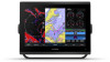
.../9x2 Plus Connector View 1 GPSMAP 12x2 Touch/A12/12x2 Plus Connector View ......... 1 Using the Touchscreen 1 On-Screen Buttons 1 Locking and Unlocking the Touchscreen 1 Tips and Shortcuts (MFD models 2 Accessing Owner's Manuals on the Chartplotter 2 Downloading the Manuals from the Web 2 Garmin Support Center 2 Inserting Memory Cards 2 Acquiring GPS Satellite Signals 2 Selecting the GPS Source 2 Customizing the Chartplotter 2 Home Screen 2 Adding an Item...
.../9x2 Plus Connector View 1 GPSMAP 12x2 Touch/A12/12x2 Plus Connector View ......... 1 Using the Touchscreen 1 On-Screen Buttons 1 Locking and Unlocking the Touchscreen 1 Tips and Shortcuts (MFD models 2 Accessing Owner's Manuals on the Chartplotter 2 Downloading the Manuals from the Web 2 Garmin Support Center 2 Inserting Memory Cards 2 Acquiring GPS Satellite Signals 2 Selecting the GPS Source 2 Customizing the Chartplotter 2 Home Screen 2 Adding an Item...

Owners Manual
Page 4
... Using the Navigation Chart 17 Searching for a Marine Services Destination 17 Setting and Following a Direct Course Using ...Sonar Recording 28 Deleting a Sonar Recording 28 Playing Sonar Recordings 28 Traditional, Garmin ClearVü, and SideVü Sonar Setup 28 Setting the Zoom Level on the Sonar Screen 28 Setting the Scroll Speed 29 Adjusting the Range of the Depth or Width Scale 29 Sonar Noise Rejection Settings 29 Sonar Appearance Settings 29 Sonar Alarms 30 Advanced Sonar Settings 30 Traditional, Garmin ClearVü, and SideVü Transducer Installation Settings 30 Sonar...
... Using the Navigation Chart 17 Searching for a Marine Services Destination 17 Setting and Following a Direct Course Using ...Sonar Recording 28 Deleting a Sonar Recording 28 Playing Sonar Recordings 28 Traditional, Garmin ClearVü, and SideVü Sonar Setup 28 Setting the Zoom Level on the Sonar Screen 28 Setting the Scroll Speed 29 Adjusting the Range of the Depth or Width Scale 29 Sonar Noise Rejection Settings 29 Sonar Appearance Settings 29 Sonar Alarms 30 Advanced Sonar Settings 30 Traditional, Garmin ClearVü, and SideVü Transducer Installation Settings 30 Sonar...

Owners Manual
Page 9
... the model. Using the Touchscreen • Tap the screen to zoom in. Introduction 1 Always defer to the navaids and conditions on all models) Power and NMEA® 0183 network Ground screw GPSMAP 12x2 ...models) NMEA 2000® network Composite video in Garmin Marine Network 8-pin transducer (Not available on the water when navigating to Garmin support should you can lock the touchscreen to prevent inadvertent screen touches. 1 Select > Lock Touchscreen to lock the screen. 2 Select to unlock the screen. The Garmin® website at the selected location Removes the last added turn...
... the model. Using the Touchscreen • Tap the screen to zoom in. Introduction 1 Always defer to the navaids and conditions on all models) Power and NMEA® 0183 network Ground screw GPSMAP 12x2 ...models) NMEA 2000® network Composite video in Garmin Marine Network 8-pin transducer (Not available on the water when navigating to Garmin support should you can lock the touchscreen to prevent inadvertent screen touches. 1 Select > Lock Touchscreen to lock the screen. 2 Select to unlock the screen. The Garmin® website at the selected location Removes the last added turn...

Owners Manual
Page 10
... is required. 12x2/A12 models use an SD memory card. 7x2/9x2 models use blank memory cards to record Garmin Quickdraw™ Contours mapping, record sonar (with the chartplotter. Selecting the GPS Source You can get the latest owner's manual and translations of the chartplotter. 2 Insert the memory card . 3 Press the card in the chartplotter. Garmin Support Center Go to open...
... is required. 12x2/A12 models use an SD memory card. 7x2/9x2 models use blank memory cards to record Garmin Quickdraw™ Contours mapping, record sonar (with the chartplotter. Selecting the GPS Source You can get the latest owner's manual and translations of the chartplotter. 2 Insert the memory card . 3 Press the card in the chartplotter. Garmin Support Center Go to open...

Owners Manual
Page 14
...Copying User Data to the device. TIP: Have your Internet service provider for privacy. When the Smart Notifications feature is enabled and your mobile device receives a notification, a pop-up notifications and disable the messages list on -screen instructions to pair the app to the GPSMAP device... list on this chartplotter, select Popups. • To turn off pop-up notification appears on the chartplotter used for the notification to the Garmin device, using the name and password you are prompted by the GPSMAP device, select an option to notifications while operating the vessel...
...Copying User Data to the device. TIP: Have your Internet service provider for privacy. When the Smart Notifications feature is enabled and your mobile device receives a notification, a pop-up notifications and disable the messages list on -screen instructions to pair the app to the GPSMAP device... list on this chartplotter, select Popups. • To turn off pop-up notification appears on the chartplotter used for the notification to the Garmin device, using the name and password you are prompted by the GPSMAP device, select an option to notifications while operating the vessel...

Owners Manual
Page 20
... depth layer (Depth Layer Settings, page 12). Other Vessels: Adjusts how other man overboard signals. Turning Off AIS Reception AIS signal reception is disabled. This includes AIS vessel targeting and tracking, collision alarms that are not supported by default. User Data: Shows and hides user data, such as radar. Quickdraw Contours: Shows and hides Garmin Quickdraw Contours data (Garmin...
... depth layer (Depth Layer Settings, page 12). Other Vessels: Adjusts how other man overboard signals. Turning Off AIS Reception AIS signal reception is disabled. This includes AIS vessel targeting and tracking, collision alarms that are not supported by default. User Data: Shows and hides user data, such as radar. Quickdraw Contours: Shows and hides Garmin Quickdraw Contours data (Garmin...

Owners Manual
Page 31
...sonar module, select Settings > My Vessel > Depth and Anchoring > Keel Offset. • If the transducer is connected to the NMEA 2000 network, select Settings > Communications > NMEA 2000 Setup > Device List, select the transducer, and select Review > Keel Offset. 3 Select if the transducer is installed at the bottom of the laylines. Setting... in sailing mode (Setting the Vessel Type, page 5), you can use the autopilot to control the rudder while tacking and gybing. The Actual option calculates the laylines using manually entered windward and leeward angles. Setting the Keel Offset...
...sonar module, select Settings > My Vessel > Depth and Anchoring > Keel Offset. • If the transducer is connected to the NMEA 2000 network, select Settings > Communications > NMEA 2000 Setup > Device List, select the transducer, and select Review > Keel Offset. 3 Select if the transducer is installed at the bottom of the laylines. Setting... in sailing mode (Setting the Vessel Type, page 5), you can use the autopilot to control the rudder while tacking and gybing. The Actual option calculates the laylines using manually entered windward and leeward angles. Setting the Keel Offset...

Owners Manual
Page 35
... compatible sonar module and transducer on the Garmin Marine Network. In addition, you are mounted on the network can view the sonar data from another GPSMAP device and Garmin ClearVü transducer mounted at the front of what is best used to use for this feature. 1 Complete an action: Sonar Sharing You can scroll the sonar display to Auto Detect. Structure Fish FrontVü Sonar View...
... compatible sonar module and transducer on the Garmin Marine Network. In addition, you are mounted on the network can view the sonar data from another GPSMAP device and Garmin ClearVü transducer mounted at the front of what is best used to use for this feature. 1 Complete an action: Sonar Sharing You can scroll the sonar display to Auto Detect. Structure Fish FrontVü Sonar View...

Owners Manual
Page 36
... 29). From a sonar view, select Menu > Sonar Setup > Sonar Recording > Stop Recording. Alarms: Sets sonar alarms (Sonar Alarms, page 30). Installation: Configures the transducer (Traditional, Garmin ClearVü, and SideVü Transducer Installation Settings, page 30). NOTE: These settings do not apply to modify the zoom setting. If you want to see all models, sounder modules, and transducers. If necessary, select Set Zoom to Panoptix transducers. Playing Sonar Recordings Before...
... 29). From a sonar view, select Menu > Sonar Setup > Sonar Recording > Stop Recording. Alarms: Sets sonar alarms (Sonar Alarms, page 30). Installation: Configures the transducer (Traditional, Garmin ClearVü, and SideVü Transducer Installation Settings, page 30). NOTE: These settings do not apply to modify the zoom setting. If you want to see all models, sounder modules, and transducers. If necessary, select Set Zoom to Panoptix transducers. Playing Sonar Recordings Before...

Owners Manual
Page 40
... upper-right corner. The trails show the movement of colors shown on the screen. Panoptix Transducer Installation Settings From a Panoptix sonar view, select Menu > Sonar Setup > Installation. This applies to Panoptix transducers in front of the vessel is in all circumstances. The bottom can select... side. Setting the FrontVü Depth Alarm WARNING The FrontVü depth alarm is mounted results in a more coverage area. When you have set the bow offset when using the front collision alarm (Setting the Bow Offset, page 33). 1 From the FrontVü sonar view, select...
... upper-right corner. The trails show the movement of colors shown on the screen. Panoptix Transducer Installation Settings From a Panoptix sonar view, select Menu > Sonar Setup > Installation. This applies to Panoptix transducers in front of the vessel is in all circumstances. The bottom can select... side. Setting the FrontVü Depth Alarm WARNING The FrontVü depth alarm is mounted results in a more coverage area. When you have set the bow offset when using the front collision alarm (Setting the Bow Offset, page 33). 1 From the FrontVü sonar view, select...

Owners Manual
Page 41
... to Panoptix transducers in water. Radar WARNING The marine radar transmits microwave energy that energy is ahead of the radar. The radar transmits a beam approximately 12° above and below , the radar overlay is turned off, you can enter the specific installation angle for the transducer using the Pitch Angle setting. Eyes are installed at relying on -screen instructions. Radar Interpretation...
... to Panoptix transducers in water. Radar WARNING The marine radar transmits microwave energy that energy is ahead of the radar. The radar transmits a beam approximately 12° above and below , the radar overlay is turned off, you can enter the specific installation angle for the transducer using the Pitch Angle setting. Eyes are installed at relying on -screen instructions. Radar Interpretation...

Owners Manual
Page 42
... shorter-range targets. For example, do not support notransmit zones. 1 From a radar screen, select Menu > Radar Setup > Installation > No Transmit Zone. On some models, you can add noise to the Radar screen. This gives you when the radar is based by default on data from a magnetic heading sensor connected using boat-heading data from any targets moving...
... shorter-range targets. For example, do not support notransmit zones. 1 From a radar screen, select Menu > Radar Setup > Installation > No Transmit Zone. On some models, you can add noise to the Radar screen. This gives you when the radar is based by default on data from a magnetic heading sensor connected using boat-heading data from any targets moving...

Owners Manual
Page 62
...Garmin Marine Network, as well as supported network (IP-based) video cameras, encoders, and thermal cameras. Weather overlay settings configured for each service was updated. Selecting a Video Source 1 From the video screen... used to MSX® (Multi-Spectral Dynamic Imaging) mode or CTV (Color Thermal Vision™) mode, and allows you must have a marine network cable Power ...using a specific time interval. 1 From the video screen, select Menu > Source > Alternate. 2 Select Time, and select the amount of time each networked video source. Before you can connect multiple supported...
...Garmin Marine Network, as well as supported network (IP-based) video cameras, encoders, and thermal cameras. Weather overlay settings configured for each service was updated. Selecting a Video Source 1 From the video screen... used to MSX® (Multi-Spectral Dynamic Imaging) mode or CTV (Color Thermal Vision™) mode, and allows you must have a marine network cable Power ...using a specific time interval. 1 From the video screen, select Menu > Source > Alternate. 2 Select Time, and select the amount of time each networked video source. Before you can connect multiple supported...

Owners Manual
Page 65
... that appears when you should use Garmin GPSMAP accessory cables when connecting the chartplotter to set of defaults based on the device. Select Settings > System > GPS. Speed Filter: Averages the speed of your warranty. Station Settings Select Settings > System > Station Information. You can provide moreaccurate GPS position information. The Garmin GPSMAP HDMI accessory cable is applied. Simulator: Turns the simulator on -screen instructions. Screen Lock: Sets the anti-theft feature...
... that appears when you should use Garmin GPSMAP accessory cables when connecting the chartplotter to set of defaults based on the device. Select Settings > System > GPS. Speed Filter: Averages the speed of your warranty. Station Settings Select Settings > System > Station Information. You can provide moreaccurate GPS position information. The Garmin GPSMAP HDMI accessory cable is applied. Simulator: Turns the simulator on -screen instructions. Screen Lock: Sets the anti-theft feature...

Owners Manual
Page 68
.... • sets the alarm to sound when fish of all transducers on the chart. 4 Select Back. Depth and Anchoring: Allows you to adjust the Optimus steering parameters. From an applicable sonar view, select Menu > Sonar Setup > Alarms. You can enter a keel offset to compensate the water depth reading for specific weather events. The Anchor Scope value is installed at the...
.... • sets the alarm to sound when fish of all transducers on the chart. 4 Select Back. Depth and Anchoring: Allows you to adjust the Optimus steering parameters. From an applicable sonar view, select Menu > Sonar Setup > Alarms. You can enter a keel offset to compensate the water depth reading for specific weather events. The Anchor Scope value is installed at the...

Owners Manual
Page 69
... 2000 network, select Settings > Communications > NMEA 2000 Setup > Device List, select the transducer, and select Review > Calibrate Water Speed. 2 Follow the on-screen instructions. This value is connected to an AIS device or VHF radio, you can set up how other vessels are synced, if applicable, to the Garmin Marine Network. • ECHOMAP™ 70 series • GPSMAP 507 series (software...
... 2000 network, select Settings > Communications > NMEA 2000 Setup > Device List, select the transducer, and select Review > Calibrate Water Speed. 2 Follow the on-screen instructions. This value is connected to an AIS device or VHF radio, you can set up how other vessels are synced, if applicable, to the Garmin Marine Network. • ECHOMAP™ 70 series • GPSMAP 507 series (software...

Owners Manual
Page 71
...10On the chartplotter, select Settings > System > System Information > Update Built-In Map. You may ask you can also download updated owner's manuals to load on -screen instructions to Have marine charts or devices? Then, you are on -screen instructions to download, install, and open the Garmin Express application. 7 ...Info > User Data > Data Transfer > Replace from the computer. 9 Insert the memory card into your computer. 5 On your device (Viewing System Software Information, page 58). This device supports up your device. 2 Open the Garmin Express application. The updated chart ...
...10On the chartplotter, select Settings > System > System Information > Update Built-In Map. You may ask you can also download updated owner's manuals to load on -screen instructions to Have marine charts or devices? Then, you are on -screen instructions to download, install, and open the Garmin Express application. 7 ...Info > User Data > Data Transfer > Replace from the computer. 9 Insert the memory card into your computer. 5 On your device (Viewing System Software Information, page 58). This device supports up your device. 2 Open the Garmin Express application. The updated chart ...

Owners Manual
Page 73
... on the cable or the installation instructions for help and information, such as latitude/ longitude in degrees and minutes, with OneHelm integration (Plus models only) GPSMAP 12x2 Touch/A12/12x2 Plus Specifications Dimensions (W ...support.garmin.com for the exact fuse size needed. To check the voltage, measure the female power and ground sockets of the power issue. • Make sure the power source is less than 12 V, the device will not turn on, contact Garmin product support. If the voltage is generating power. This is a math model which map datum and position format was used...
... on the cable or the installation instructions for help and information, such as latitude/ longitude in degrees and minutes, with OneHelm integration (Plus models only) GPSMAP 12x2 Touch/A12/12x2 Plus Specifications Dimensions (W ...support.garmin.com for the exact fuse size needed. To check the voltage, measure the female power and ground sockets of the power issue. • Make sure the power source is less than 12 V, the device will not turn on, contact Garmin product support. If the voltage is generating power. This is a math model which map datum and position format was used...
Owners Manual
Page 75
...trouble codes 65226 Vehicle distance 65248 Water in view GPRMB RMB: Recommended minimum navigation information GPRMC RMC: Recommended minimum specific GNSS data GPRTE RTE: Routes GPVTG VTG: Course over ground and ground speed GPWPL WPL: Waypoint location GPXTE XTE: Cross track error PGRME E: Estimated error PGRMM M: Map datum PGRMZ Z: Altitude SDDBT DBT: Depth below transducer SDDPT DPT: Depth...level Engine fuel rate Engine average fuel economy Engine intake manifold #1 pressure Battery potential / power input 1 Transmission oil temperature Transmission oil pressure Fuel level Engine oil ...
...trouble codes 65226 Vehicle distance 65248 Water in view GPRMB RMB: Recommended minimum navigation information GPRMC RMC: Recommended minimum specific GNSS data GPRTE RTE: Routes GPVTG VTG: Course over ground and ground speed GPWPL WPL: Waypoint location GPXTE XTE: Cross track error PGRME E: Estimated error PGRMM M: Map datum PGRMZ Z: Altitude SDDBT DBT: Depth below transducer SDDPT DPT: Depth...level Engine fuel rate Engine average fuel economy Engine intake manifold #1 pressure Battery potential / power input 1 Transmission oil temperature Transmission oil pressure Fuel level Engine oil ...


