
Owner's Manual
Page 3
... the contents of unit features to create an unsurpassed portable GPS receiver. Read the Safety Information to configure your Garmin dealer immediately. If any pieces are also step-by -step directions on the outside of the manual for choosing the Garmin® GPSMAP® 176/176C. The Main Menu chapter provides detailed explanations about features...
... the contents of unit features to create an unsurpassed portable GPS receiver. Read the Safety Information to configure your Garmin dealer immediately. If any pieces are also step-by -step directions on the outside of the manual for choosing the Garmin® GPSMAP® 176/176C. The Main Menu chapter provides detailed explanations about features...
Owner's Manual
Page 5
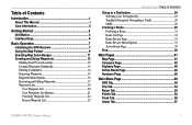
Table of Contents Introduction i About This Manual i Care Information ii Getting Started 3 Unit Basics 3 Interface Keys 6 Basic Operation 7 Initializing the GPS Receiver 7 Using the Map Pointer 9 Selecting Map Zoom Ranges 11 Creating and Using Waypoints 12 Marking Your Present Location 12 Creating Waypoints Graphically 13 Entering ...Find 39 Main Pages 41 Map Page 41 Compass Page 45 Highway Page 46 Active Route Page 48 Numbers Page 48 Main Menu Page 49 GPS Tab 50 Trip Tab 54 Route Tab 54 Points Tab 54 Track Tab 55 Alarm Tab 57 GPSMAP 176/176C Owner's Manual 1
Table of Contents Introduction i About This Manual i Care Information ii Getting Started 3 Unit Basics 3 Interface Keys 6 Basic Operation 7 Initializing the GPS Receiver 7 Using the Map Pointer 9 Selecting Map Zoom Ranges 11 Creating and Using Waypoints 12 Marking Your Present Location 12 Creating Waypoints Graphically 13 Entering ...Find 39 Main Pages 41 Map Page 41 Compass Page 45 Highway Page 46 Active Route Page 48 Numbers Page 48 Main Menu Page 49 GPS Tab 50 Trip Tab 54 Route Tab 54 Points Tab 54 Track Tab 55 Alarm Tab 57 GPSMAP 176/176C Owner's Manual 1
Owner's Manual
Page 11
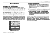
... GPS RECEIVER To initialize the GPS receiver: 1. Following the screen prompts, press ENTER to satellites while updating the Almanac. When the unit is able to navigate, the message 2D GPS Location or 3D GPS Location is no longer valid and your unit may take a few minutes. The unit searches for navigation. BASIC OPERATION Initializing the GPS Receiver The GPSMAP 176/176C...
... GPS RECEIVER To initialize the GPS receiver: 1. Following the screen prompts, press ENTER to satellites while updating the Almanac. When the unit is able to navigate, the message 2D GPS Location or 3D GPS Location is no longer valid and your unit may take a few minutes. The unit searches for navigation. BASIC OPERATION Initializing the GPS Receiver The GPSMAP 176/176C...
Owner's Manual
Page 12
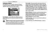
... and allows the map to acquire satellites. BASIC OPERATION > INITIALIZING THE GPS RECEIVER Initialization Options If the GPSMAP 176/176C is displayed with the options Automatic or Use Map. Start Simulator-turns the GPS receiver off . When the unit is set to simulator mode, the GPS receiver is selected, the unit switches to determine its location, an options menu...
... and allows the map to acquire satellites. BASIC OPERATION > INITIALIZING THE GPS RECEIVER Initialization Options If the GPSMAP 176/176C is displayed with the options Automatic or Use Map. Start Simulator-turns the GPS receiver off . When the unit is set to simulator mode, the GPS receiver is selected, the unit switches to determine its location, an options menu...

Owner's Manual
Page 54
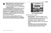
... The signal strength is still in relation to the receiver's last known position. MAIN MENU > GPS TAB GPS Tab The GPS tab provides a visual reference of receiving WAAS (Wide Area Augmentation System) satellite signals. As soon as the GPSMAP 176/176C has collected the necessary data from this time, the..., now in a geostationary orbit over the Pacific Ocean, in developmental service. 50 GPSMAP 176/176C Owner's Manual The status information shows what satellites are visible to the receiver and whether or not they are ready for use of the WAAS satellite signal may also ...
... The signal strength is still in relation to the receiver's last known position. MAIN MENU > GPS TAB GPS Tab The GPS tab provides a visual reference of receiving WAAS (Wide Area Augmentation System) satellite signals. As soon as the GPSMAP 176/176C has collected the necessary data from this time, the..., now in a geostationary orbit over the Pacific Ocean, in developmental service. 50 GPSMAP 176/176C Owner's Manual The status information shows what satellites are visible to the receiver and whether or not they are ready for use of the WAAS satellite signal may also ...
Owner's Manual
Page 55
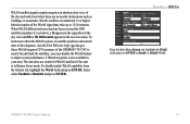
... are numbered 33 or higher. MAIN MENU > GPS TAB From the Main Menu System tab, highlight the WAAS field and press ENTER to 15-20 minutes. Select either Enabled or Disabled and press ENTER. GPSMAP 176/176C Owner's Manual 51 When WAAS differential correction has been received for and track the satellites, you may...
... are numbered 33 or higher. MAIN MENU > GPS TAB From the Main Menu System tab, highlight the WAAS field and press ENTER to 15-20 minutes. Select either Enabled or Disabled and press ENTER. GPSMAP 176/176C Owner's Manual 51 When WAAS differential correction has been received for and track the satellites, you may...

Owner's Manual
Page 56
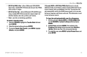
... enough satellites for a 2D or 3D fix. • Receiver Not Usable-the receiver is unusable, possibly due to reset. • Simulating GPS-the receiver is in simulator mode. • GPS Off-the GPS receiver is turned off and back on the strength bar of satellites ...GPS Location-at its last known or initialized position, but not transmitting RTCM data to GPS. • Tuning Beacon-receiver is tuning manual DGPS frequency. • Using Differential-unit is receiving DGPS corrections. • Scanning for Beacon-DGPS receiver is scanning for an available frequency. 52 GPSMAP 176/176C...
... enough satellites for a 2D or 3D fix. • Receiver Not Usable-the receiver is unusable, possibly due to reset. • Simulating GPS-the receiver is in simulator mode. • GPS Off-the GPS receiver is turned off and back on the strength bar of satellites ...GPS Location-at its last known or initialized position, but not transmitting RTCM data to GPS. • Tuning Beacon-receiver is tuning manual DGPS frequency. • Using Differential-unit is receiving DGPS corrections. • Scanning for Beacon-DGPS receiver is scanning for an available frequency. 52 GPSMAP 176/176C...
Owner's Manual
Page 57
... DGPS corrections at the same time. Any altitude entered is automatically calculated when the GPS is used with the GPSMAP 176/176C, the DGPS Rcvr field displays Off. GPSMAP 176/176C Owner's Manual 53 NOTE: If a DGPS receiver is attached to the unit and Garmin DGPS, RTCM In/NMEA Out, or Other DGPS is enabled on Port 2, WAAS...
... DGPS corrections at the same time. Any altitude entered is automatically calculated when the GPS is used with the GPSMAP 176/176C, the DGPS Rcvr field displays Off. GPSMAP 176/176C Owner's Manual 53 NOTE: If a DGPS receiver is attached to the unit and Garmin DGPS, RTCM In/NMEA Out, or Other DGPS is enabled on Port 2, WAAS...

Owner's Manual
Page 78
...; Garmin DGPS-used to connect the GPSMAP 176/176C with a PC or another Garmin GPSMAP 176/176C. Interface Tab NOTE: If a DGPS receiver is used, WAAS capability is automatically turned Off. • Garmin Data Transfer-the proprietary format used when connecting your GPSMAP 176/176C to external NMEA devices, a DGPS beacon receiver, a personal computer, or another Garmin GPSMAP 176/176C. When...sentences. • Text Out-allows the unit to 1200, 2400, 4800, or 9600bps. • RTCM In-allows Differential GPS (DGPS) input using a standard RTCM format. 74 GPSMAP 176/176C Owner's Manual
...; Garmin DGPS-used to connect the GPSMAP 176/176C with a PC or another Garmin GPSMAP 176/176C. Interface Tab NOTE: If a DGPS receiver is used, WAAS capability is automatically turned Off. • Garmin Data Transfer-the proprietary format used when connecting your GPSMAP 176/176C to external NMEA devices, a DGPS beacon receiver, a personal computer, or another Garmin GPSMAP 176/176C. When...sentences. • Text Out-allows the unit to 1200, 2400, 4800, or 9600bps. • RTCM In-allows Differential GPS (DGPS) input using a standard RTCM format. 74 GPSMAP 176/176C Owner's Manual
Owner's Manual
Page 79
... frequency: 1. The numbers in the Frequency field change as the unit scans from 284 kHz to control a Garmin differential beacon receiver directly from your GPSMAP 176/176C. GPSMAP 176/176C Owner's Manual 75 Using the ROCKER, highlight the Transfer Mode field and press ENTER. 2. Select the desired ...Scan and press ENTER. • RTCM In/NMEA Out-allows Differential GPS (DGPS) input using a standard RTCM format and also provides NMEA 0183 version 2.3 output. • RTCM In/Text Out-allows Differential GPS (DGPS) input using a standard RTCM format and also outputs simple ...
... frequency: 1. The numbers in the Frequency field change as the unit scans from 284 kHz to control a Garmin differential beacon receiver directly from your GPSMAP 176/176C. GPSMAP 176/176C Owner's Manual 75 Using the ROCKER, highlight the Transfer Mode field and press ENTER. 2. Select the desired ...Scan and press ENTER. • RTCM In/NMEA Out-allows Differential GPS (DGPS) input using a standard RTCM format and also provides NMEA 0183 version 2.3 output. • RTCM In/Text Out-allows Differential GPS (DGPS) input using a standard RTCM format and also outputs simple ...
Owner's Manual
Page 82
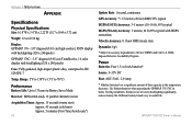
... significant amount of screen backlighting significantly reduces battery life. GPSMAP 176/176C Owner's Manual Use lithium batteries when operating the GPSMAP 176/176C in useful life. Different battery brands vary in below freezing conditions. APPENDIX ...176;F (-15°C to 70°C) Performance Battery Life: Up to 13 hours in Battery Saver Mode Receiver: Differential-ready 12 parallel channel receiver Acquisition Times: Approx. 15 seconds (warm start) Approx. 45 seconds (cold start) Approx. 5 minutes (First Time/AutoLocate®) 78 Update Rate: 1/second, continuous GPS...
... significant amount of screen backlighting significantly reduces battery life. GPSMAP 176/176C Owner's Manual Use lithium batteries when operating the GPSMAP 176/176C in useful life. Different battery brands vary in below freezing conditions. APPENDIX ...176;F (-15°C to 70°C) Performance Battery Life: Up to 13 hours in Battery Saver Mode Receiver: Differential-ready 12 parallel channel receiver Acquisition Times: Approx. 15 seconds (warm start) Approx. 45 seconds (cold start) Approx. 5 minutes (First Time/AutoLocate®) 78 Update Rate: 1/second, continuous GPS...

Owner's Manual
Page 83
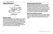
.../23 Beacon Receiver Interfacing The following are supported for NMEA 0183, version 2.3 output: Approved sentences-GPRMC, GPGGA, GPGSA, GPGSV, GPGLL, GPBOD, GPRTE, and GPWPL. APPENDIX > SATELLITE INFORMATION The following formats are the sentences for connection of our Web site at www.garmin.com. Proprietary sentences-PGRME, PGRMZ, and PSLIB. The GPSMAP 176/176C accepts NMEA...
.../23 Beacon Receiver Interfacing The following are supported for NMEA 0183, version 2.3 output: Approved sentences-GPRMC, GPGGA, GPGSA, GPGSV, GPGLL, GPBOD, GPRTE, and GPWPL. APPENDIX > SATELLITE INFORMATION The following formats are the sentences for connection of our Web site at www.garmin.com. Proprietary sentences-PGRME, PGRMZ, and PSLIB. The GPSMAP 176/176C accepts NMEA...
Owner's Manual
Page 84
... the process of storing orbital data it is receiving from the satellite's on the Satellite Information page. When the GPS receiver has achieved a 2D or 3D GPS location, the current location is displayed in the selected location format. 80 GPSMAP 176/176C Owner's Manual When the bar turns solid, the GPS is using a satellite for navigation. Date, Time...
... the process of storing orbital data it is receiving from the satellite's on the Satellite Information page. When the GPS receiver has achieved a 2D or 3D GPS location, the current location is displayed in the selected location format. 80 GPSMAP 176/176C Owner's Manual When the bar turns solid, the GPS is using a satellite for navigation. Date, Time...
Owner's Manual
Page 90
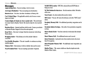
...Garmin Product Support to have entered a route name that Area-No tide stations within 100 miles of the area. Route Memory Full-No additional routes can be saved. Route Truncated-Uploaded route from another device has more maps was found too many items to continue receiving satellite signals. GPSMAP 176/176C... Memory Full-No additional route waypoints can be saved. Shallow Water-The water is being received. Arriving at Destination-You are nearing a proximity waypoint. 86 No Diff GPS Location-RTCM is selected but no further data can be saved. Dragging Anchor-The distance ...
...Garmin Product Support to have entered a route name that Area-No tide stations within 100 miles of the area. Route Memory Full-No additional routes can be saved. Route Truncated-Uploaded route from another device has more maps was found too many items to continue receiving satellite signals. GPSMAP 176/176C... Memory Full-No additional route waypoints can be saved. Shallow Water-The water is being received. Arriving at Destination-You are nearing a proximity waypoint. 86 No Diff GPS Location-RTCM is selected but no further data can be saved. Dragging Anchor-The distance ...

Owner's Manual
Page 92
... waypoints using GPS. The LORAN system covers the entire United States and the U.S. From the perspective of a LORAN receiver. After the waypoint is stored in the United States by recreational vehicles. 88 LORAN TD Feature The LORAN TD (Time Delay) feature eases the transition from this conversion is approximately thirty meters. GPSMAP 176/176C Owner...
... waypoints using GPS. The LORAN system covers the entire United States and the U.S. From the perspective of a LORAN receiver. After the waypoint is stored in the United States by recreational vehicles. 88 LORAN TD Feature The LORAN TD (Time Delay) feature eases the transition from this conversion is approximately thirty meters. GPSMAP 176/176C Owner...


