Instructions
Page 2
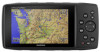
... mm (1/16 in.) drill bit Mounting Considerations NOTICE The swivel base must be mounted using pan-head machine bolts or self-tapping screws. Garmin® strongly recommends having an experienced installer with countersunk heads can damage the mounting bracket. The device should be mounted in .) of the ... metal contacts on the mount at least 8 cm (3 in a location that is easy to reach. Use the weather cap on the GPS device and the mount should allow at all installation instructions before proceeding with the installation. To obtain the best performance and to avoid damage to...
... mm (1/16 in.) drill bit Mounting Considerations NOTICE The swivel base must be mounted using pan-head machine bolts or self-tapping screws. Garmin® strongly recommends having an experienced installer with countersunk heads can damage the mounting bracket. The device should be mounted in .) of the ... metal contacts on the mount at least 8 cm (3 in a location that is easy to reach. Use the weather cap on the GPS device and the mount should allow at all installation instructions before proceeding with the installation. To obtain the best performance and to avoid damage to...
Instructions
Page 2
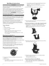
Handlebar Mount Instructions WARNING See the Important Safety and Product Information guide in the GPS device product box for the mount. À 3 Tilt the device forward, and lift it out of the mount. 2 Place the head of each screw in ...
Handlebar Mount Instructions WARNING See the Important Safety and Product Information guide in the GPS device product box for the mount. À 3 Tilt the device forward, and lift it out of the mount. 2 Place the head of each screw in ...
Owner s Manual PDF
Page 3
...Installing the Battery Pack 2 Turning On the Device 2 Adjusting the Backlight Brightness and Volume 2 Support and Updates 2 Setting Up Garmin Express 2 Connected Features 2 Connected Feature Requirements 2 Setting Up Wi‑Fi Connectivity 3 Connecting to a Wireless Network 3 ...Settings 8 Map Settings 8 Marine Settings 8 Marine Navigation Settings 8 Trip Computer Settings 8 Highway Page Settings 8 Alarms Settings 8 GPS Satellite Settings 9 System Settings 9 Serial Interface Settings 9 Display Settings 9 Routing Settings 9 Tracks Settings 9 Altimeter Settings 10 Sound...
...Installing the Battery Pack 2 Turning On the Device 2 Adjusting the Backlight Brightness and Volume 2 Support and Updates 2 Setting Up Garmin Express 2 Connected Features 2 Connected Feature Requirements 2 Setting Up Wi‑Fi Connectivity 3 Connecting to a Wireless Network 3 ...Settings 8 Map Settings 8 Marine Settings 8 Marine Navigation Settings 8 Trip Computer Settings 8 Highway Page Settings 8 Alarms Settings 8 GPS Satellite Settings 9 System Settings 9 Serial Interface Settings 9 Display Settings 9 Routing Settings 9 Tracks Settings 9 Altimeter Settings 10 Sound...

Owner s Manual PDF
Page 5
...; Turn off GLONASS (Enabling GLONASS and WAAS, page 3). Device Overview Battery cover D-ring À microSD card slot (under battery door) Á MCX port for external GPS antenna (under weather cap) Â Mini-USB port (under weather cap) Ã Power connector for the device may exceed the usable range of their capacity...
...; Turn off GLONASS (Enabling GLONASS and WAAS, page 3). Device Overview Battery cover D-ring À microSD card slot (under battery door) Á MCX port for external GPS antenna (under weather cap) Â Mini-USB port (under weather cap) Ã Power connector for the device may exceed the usable range of their capacity...

Owner s Manual PDF
Page 7
... should pair your GPSMAP 276Cx device directly through the Garmin Connect Mobile app on your current track toward the top of satellites available to enable Wi‑Fi technology. 3 Select Add Network. 4 Select a wireless network from the list. 5 If necessary, enter the password. Acquiring Satellite Signals Before you can use GPS navigation features, you...
... should pair your GPSMAP 276Cx device directly through the Garmin Connect Mobile app on your current track toward the top of satellites available to enable Wi‑Fi technology. 3 Select Add Network. 4 Select a wireless network from the list. 5 If necessary, enter the password. Acquiring Satellite Signals Before you can use GPS navigation features, you...

Owner s Manual PDF
Page 9
..., select Move Waypoint, and use the arrow keys. • To remove the point from your device to your computer for saving and viewing using the Garmin BaseCamp™ application. Stopping Navigation Select NAV > Stop Navigation. System setting changes for units of tracks. Clearing the Active Track From the main menu, select... plan the trip. The device recalculates your current track recording. Viewing the Active Route 1 While navigating a route, from the current track log on and receiving a GPS signal. If you to navigate the route in units per hour.
..., select Move Waypoint, and use the arrow keys. • To remove the point from your device to your computer for saving and viewing using the Garmin BaseCamp™ application. Stopping Navigation Select NAV > Stop Navigation. System setting changes for units of tracks. Clearing the Active Track From the main menu, select... plan the trip. The device recalculates your current track recording. Viewing the Active Route 1 While navigating a route, from the current track log on and receiving a GPS signal. If you to navigate the route in units per hour.

Owner s Manual PDF
Page 11
... Reset Odometer to reset the odometer value to zero. • Select Reset All to reset all trip computer values to a smartphone with Garmin Connect Mobile (Pairing a Smartphone with the Map, page 6). Viewing Current Weather Conditions and Forecasts To view current weather forecast information, you navigate...an option: • Select Current Elevation, and enter the elevation. • Select Sea Level Pressure, and enter the pressure. • Select GPS Altitude. 4 Select Calibrate. Navigating to a Point on the Elevation Plot 1 Use the arrow keys to the current day. You can download and ...
... Reset Odometer to reset the odometer value to zero. • Select Reset All to reset all trip computer values to a smartphone with Garmin Connect Mobile (Pairing a Smartphone with the Map, page 6). Viewing Current Weather Conditions and Forecasts To view current weather forecast information, you navigate...an option: • Select Current Elevation, and enter the elevation. • Select Sea Level Pressure, and enter the pressure. • Select GPS Altitude. 4 Select Calibrate. Navigating to a Point on the Elevation Plot 1 Use the arrow keys to the current day. You can download and ...

Owner s Manual PDF
Page 13
NOTE: Some settings are saved and cleared automatically. Use With GPS Off: Allows you exceed a specified drift distance while anchored. Interface: Sets the format of location and velocity information. Garmin Spanner: Allows you to adjust the backlight for transportation while routing. Text Out:... organize your activity with most useful when driving or navigating on the map. MTP: Sets the device to use a Garmin proprietary format to use Wide Area Augmentation System/European Geostationary Navigation Overlay Service (WAAS/EGNOS) data. Routing Settings The available...
NOTE: Some settings are saved and cleared automatically. Use With GPS Off: Allows you exceed a specified drift distance while anchored. Interface: Sets the format of location and velocity information. Garmin Spanner: Allows you to adjust the backlight for transportation while routing. Text Out:... organize your activity with most useful when driving or navigating on the map. MTP: Sets the device to use a Garmin proprietary format to use Wide Area Augmentation System/European Geostationary Navigation Overlay Service (WAAS/EGNOS) data. Routing Settings The available...

Owner s Manual PDF
Page 14
...Trip option resets the track and trip data when you to automatically calibrate the altimeter as long as the device receives GPS signals and the Continuous calibration option is structured. The Fixed Elevation option assumes the device is started. The device continues...moving. Calibrate Altimeter: Allows you to reset. Sound Settings From the main menu, select Setup > Sound. Beeper: Sets the beeper to appear on your GPS position. Voice Language: Sets the language for distance and speed, elevation, depth, temperature, pressure, and vertical speed. 1 Select Setup > Units. 2...
...Trip option resets the track and trip data when you to automatically calibrate the altimeter as long as the device receives GPS signals and the Continuous calibration option is structured. The Fixed Elevation option assumes the device is started. The device continues...moving. Calibrate Altimeter: Allows you to reset. Sound Settings From the main menu, select Setup > Sound. Beeper: Sets the beeper to appear on your GPS position. Voice Language: Sets the language for distance and speed, elevation, depth, temperature, pressure, and vertical speed. 1 Select Setup > Units. 2...

Owner s Manual PDF
Page 15
... You can store files on the device. 3 Plug the large end of the ANT+ accessory. • After you pair the first time, your Garmin device automatically recognizes the ANT+ accessory each time it . The device has a memory card slot for exporting to your computer. 4 Place the memory card..., you must safely disconnect your device from your device, the sensor status changes from Searching to Connected. NOTE: Some computers with AA batteries GPS on your device. See your operating system documentation to learn how to map the drive. 2 On your Windows computer as mounted volumes. If...
... You can store files on the device. 3 Plug the large end of the ANT+ accessory. • After you pair the first time, your Garmin device automatically recognizes the ANT+ accessory each time it . The device has a memory card slot for exporting to your computer. 4 Place the memory card..., you must safely disconnect your device from your device, the sensor status changes from Searching to Connected. NOTE: Some computers with AA batteries GPS on your device. See your operating system documentation to learn how to map the drive. 2 On your Windows computer as mounted volumes. If...
Owner s Manual PDF
Page 17
... 8 D data, transferring 11 data fields 8 deleting, all user data 11 device, care 10 E elevation 6 plot 7 F files, transferring 11 finding locations 6 G Garmin Connect 2, 3 Garmin Express 2, 3 registering the device 2 updating software 2 geocaches 11 GLONASS 3 GPS 3 satellite page 9 settings 9 signal 3 H HomePort 11 hunting and fishing times 7 K keys 1 L locations editing 4 saving 4 M main menu, using 1 man overboard (MOB...
... 8 D data, transferring 11 data fields 8 deleting, all user data 11 device, care 10 E elevation 6 plot 7 F files, transferring 11 finding locations 6 G Garmin Connect 2, 3 Garmin Express 2, 3 registering the device 2 updating software 2 geocaches 11 GLONASS 3 GPS 3 satellite page 9 settings 9 signal 3 H HomePort 11 hunting and fishing times 7 K keys 1 L locations editing 4 saving 4 M main menu, using 1 man overboard (MOB...

Owner s Manual Web
Page 2
... attempting such operations. • When navigating, carefully compare information displayed on the device to provide route suggestions only. To purchase replacement batteries, see your Garmin device. 2 GPS Notice The navigation device may not cause harmful interference, and (2) this product is designed to all -terrain vehicles, follow route suggestions if they suggest an...
... attempting such operations. • When navigating, carefully compare information displayed on the device to provide route suggestions only. To purchase replacement batteries, see your Garmin device. 2 GPS Notice The navigation device may not cause harmful interference, and (2) this product is designed to all -terrain vehicles, follow route suggestions if they suggest an...

