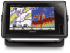

Quick Reference Guide
Page 1
...an existing waypoint: 1. Select the waypoint you want to save the new location. From the Navigation chart, use Automatic Guidance. 6. Select Review > Delete (The Review button is only shown when more than one waypoint is in the vicinity.) 3. Select Navigate To. 5. Use the map pointer ( ... From the Home screen, select Information > User Data > Waypoints. 2. From the Home screen, select Where To?. 2. Select a category. 3. Select Review. (The Review button is only shown when more than one waypoint is in the vicinity.) GPSMAP® 400/500 series quick reference guide
...an existing waypoint: 1. Select the waypoint you want to save the new location. From the Navigation chart, use Automatic Guidance. 6. Select Review > Delete (The Review button is only shown when more than one waypoint is in the vicinity.) 3. Select Navigate To. 5. Use the map pointer ( ... From the Home screen, select Information > User Data > Waypoints. 2. From the Home screen, select Where To?. 2. Select a category. 3. Select Review. (The Review button is only shown when more than one waypoint is in the vicinity.) GPSMAP® 400/500 series quick reference guide

Owner's Manual
Page 17
...). Photos-sets the high-resolution satellite images to show animated tide station indicators and animated current direction indicators on -screen map items, waypoints, and charts. GPSMAP 400/500 Series Owner's Manual 11 Accessing Additional Object Information Use the map pointer ( ) to view information about tides, see page 37. Tides/Currents-turns... Charts Viewing Tide-Station Information Tide-station information appears on different days. To access additional object information: 1. You can view an in the area, select Review, and then select the item.
...). Photos-sets the high-resolution satellite images to show animated tide station indicators and animated current direction indicators on -screen map items, waypoints, and charts. GPSMAP 400/500 Series Owner's Manual 11 Accessing Additional Object Information Use the map pointer ( ) to view information about tides, see page 37. Tides/Currents-turns... Charts Viewing Tide-Station Information Tide-station information appears on different days. To access additional object information: 1. You can view an in the area, select Review, and then select the item.

Owner's Manual
Page 26
...the height of the tide at the station appears above the station indicator. Tide Station with the pointer, and select Aerial Photo or Review. Perspective Overhead Animated Tide and Current Indicators You can view indicators for tide station and current direction must also select the Animated value for... chart. Using Charts To access aerial photos from the Navigation chart: Use the Rocker to highlight a camera icon with Falling Tide 20 GPSMAP 400/500 Series Owner's Manual To do so, information for animated tide station and current direction on the chart as a vertical bar ...
...the height of the tide at the station appears above the station indicator. Tide Station with the pointer, and select Aerial Photo or Review. Perspective Overhead Animated Tide and Current Indicators You can view indicators for tide station and current direction must also select the Animated value for... chart. Using Charts To access aerial photos from the Navigation chart: Use the Rocker to highlight a camera icon with Falling Tide 20 GPSMAP 400/500 Series Owner's Manual To do so, information for animated tide station and current direction on the chart as a vertical bar ...

Owner's Manual
Page 31
...waypoint attribute you want to the location where you want create the waypoint. Select the waypoint on the Navigation chart. Select Review. (The Review button is in the vicinity.) 3. To mark your current location. Press SELECT to save the new location, or press...current location as a Man Overboard location. OR From the Home screen, select Information > User Data > Waypoints. 2. To edit an existing waypoint: 1. GPSMAP 400/500 Series Owner's Manual 25 Select Edit Waypoint. 4. OR From the Home screen, select Information > User Data > Waypoints > Options > New Waypoint...
...waypoint attribute you want to the location where you want create the waypoint. Select the waypoint on the Navigation chart. Select Review. (The Review button is in the vicinity.) 3. To mark your current location. Press SELECT to save the new location, or press...current location as a Man Overboard location. OR From the Home screen, select Information > User Data > Waypoints. 2. To edit an existing waypoint: 1. GPSMAP 400/500 Series Owner's Manual 25 Select Edit Waypoint. 4. OR From the Home screen, select Information > User Data > Waypoints > Options > New Waypoint...

Owner's Manual
Page 32
..., with up to view details of objects in the vicinity of the screen. To delete a waypoint or an MOB: 1. Select an option. • Select Review or the name of the waypoint to 250 waypoints each. Use the Rocker to move the pointer and measure the distance to remove the measuring...the cursor. From the Navigation chart, use the map pointer ( ) to highlight the object on the Navigation chart: 1. To create a route from your destination. 26 GPSMAP 400/500 Series Owner's Manual You can then sort the list by name, by symbol, or by name or symbol. OR From the Home screen...
..., with up to view details of objects in the vicinity of the screen. To delete a waypoint or an MOB: 1. Select an option. • Select Review or the name of the waypoint to 250 waypoints each. Use the Rocker to move the pointer and measure the distance to remove the measuring...the cursor. From the Navigation chart, use the map pointer ( ) to highlight the object on the Navigation chart: 1. To create a route from your destination. 26 GPSMAP 400/500 Series Owner's Manual You can then sort the list by name, by symbol, or by name or symbol. OR From the Home screen...

Owner's Manual
Page 48
...SART) are self-contained devices that are different than standard AIS transmissions, so they look different than standard AIS symbols on the Navigation Chart 42 GPSMAP 400/500 Series Owner's Manual The direction in which the triangle is pointing indicates the direction in which the AIS vessel is selected. Target ...transmitting AIS information. The vessel is reporting AIS information. The information reported for collision avoidance, you receive a SART transmission, a distress signal alarm appears. Select Review > Go To to begin navigation to locate and assist a vessel.
...SART) are self-contained devices that are different than standard AIS transmissions, so they look different than standard AIS symbols on the Navigation Chart 42 GPSMAP 400/500 Series Owner's Manual The direction in which the triangle is pointing indicates the direction in which the AIS vessel is selected. Target ...transmitting AIS information. The vessel is reporting AIS information. The information reported for collision avoidance, you receive a SART transmission, a distress signal alarm appears. Select Review > Go To to begin navigation to locate and assist a vessel.

Owner's Manual
Page 56
... placed an appropriate distance from shore, you have navigated to allow when calculating an automatic guidance path. Complete an action: 50 GPSMAP 400/500 Series Owner's Manual Speed Sources-specify the sensor used for saved routes, this determines whether route turns are relative, not.... • Shoreline Distance-set how much time or how far before a turn in a route that require navigation through a narrow waterway. Review the placement of less than one or more familiar destinations that you change navigation preferences, from the shore: Nearest, Near, Normal, Far, or...
... placed an appropriate distance from shore, you have navigated to allow when calculating an automatic guidance path. Complete an action: 50 GPSMAP 400/500 Series Owner's Manual Speed Sources-specify the sensor used for saved routes, this determines whether route turns are relative, not.... • Shoreline Distance-set how much time or how far before a turn in a route that require navigation through a narrow waterway. Review the placement of less than one or more familiar destinations that you change navigation preferences, from the shore: Nearest, Near, Normal, Far, or...
Owner's Manual
Page 57
...; If the Auto Guidance line is too close to external NMEA devices, a computer, or other Garmin devices. • Garmin Data Transfer-supports the input or output of Garmin-proprietary data for communicating with the functionality of standard 0183 data for serial port 1 to use when... > Shoreline Distance > Farthest. • If the turns in step 7, review the placement of the Auto Guidance line. Determine whether the line safely avoids known obstacles, and whether the turns enable efficient travel . 9. GPSMAP 400/500 Series Owner's Manual 51 Repeat steps 1-10 at least once more...
...; If the Auto Guidance line is too close to external NMEA devices, a computer, or other Garmin devices. • Garmin Data Transfer-supports the input or output of Garmin-proprietary data for communicating with the functionality of standard 0183 data for serial port 1 to use when... > Shoreline Distance > Farthest. • If the turns in step 7, review the placement of the Auto Guidance line. Determine whether the line safely avoids known obstacles, and whether the turns enable efficient travel . 9. GPSMAP 400/500 Series Owner's Manual 51 Repeat steps 1-10 at least once more...
Owner's Manual
Page 69
...is tracking the position of the vessel, and select Done. Digital Selective Calling Receiving Distress Calls If your Garmin chartplotter and VHF radio are using a Garmin NMEA 2000-compatible VHF radio. • Select Edit to delete the call . 1. If position information ...was sent. Complete one of a vessel on making an individual routine call report. If your VHF radio receives a DSC distress call . Select Review to toggle it replaces the first call . GPSMAP...
...is tracking the position of the vessel, and select Done. Digital Selective Calling Receiving Distress Calls If your Garmin chartplotter and VHF radio are using a Garmin NMEA 2000-compatible VHF radio. • Select Edit to delete the call . 1. If position information ...was sent. Complete one of a vessel on making an individual routine call report. If your VHF radio receives a DSC distress call . Select Review to toggle it replaces the first call . GPSMAP...

Owner's Manual
Page 72
... routine call to the radio. 5. Select the station to an AIS target: 1. Calling an AIS Target When you connect your Garmin chartplotter to a Garmin VHF NMEA 2000-compatible radio, you can use the Rocker to an AIS target. To make an individual routine call from the list.... 3. On your Garmin VHF radio, select Call. 66 GPSMAP 400/500 Series Owner's Manual On your Garmin VHF radio, select Call. Select Review > Call with Radio. 3. While viewing a chart, press MENU > Other Vessels > DSC > DSC ...
... routine call to the radio. 5. Select the station to an AIS target: 1. Calling an AIS Target When you connect your Garmin chartplotter to a Garmin VHF NMEA 2000-compatible radio, you can use the Rocker to an AIS target. To make an individual routine call from the list.... 3. On your Garmin VHF radio, select Call. 66 GPSMAP 400/500 Series Owner's Manual On your Garmin VHF radio, select Call. Select Review > Call with Radio. 3. While viewing a chart, press MENU > Other Vessels > DSC > DSC ...

Technical Reference for Garmin NMEA 2000 Products
Page 30
...it is complete. Perform the gauge-type setting test. Select an option: • For most Garmin chartplotters, select Review > Rudder Angle Calibration. • For other Garmin marine devices, select Config > Rudder Angle Calibration. 4. If the rudder-angle reading on your display.... 5. To access the NMEA 2000 configuration menu on a connected Garmin chartplotter or marine instrument changes with . 1. Select an option: • For most Garmin chartplotters, select Review > Generic Config. • For other Garmin marine devices, select Config > Gauge Type. 3. From the NMEA...
...it is complete. Perform the gauge-type setting test. Select an option: • For most Garmin chartplotters, select Review > Rudder Angle Calibration. • For other Garmin marine devices, select Config > Rudder Angle Calibration. 4. If the rudder-angle reading on your display.... 5. To access the NMEA 2000 configuration menu on a connected Garmin chartplotter or marine instrument changes with . 1. Select an option: • For most Garmin chartplotters, select Review > Generic Config. • For other Garmin marine devices, select Config > Gauge Type. 3. From the NMEA...

Technical Reference for Garmin NMEA 2000 Products
Page 31
... enter one -coil gauge, enter 1, followed by Done. Select an option: • For most Garmin chartplotters, select Review > Engine Tilt Calibration. • For other Garmin marine devices, select Config >Generic Configuration. 3. Follow the on-screen instructions to . NMEA 2000-Certified ... following command: "RUDDERPOS=" 11. For example, RUDDERPOS=-45Done. Select an option: • For most Garmin chartplotters, select Review > Generic Config. • For other Garmin marine devices, select Config >Generic Configuration. 3. Calibrating the Engine Tilt To use the GET 10 adapter,...
... enter one -coil gauge, enter 1, followed by Done. Select an option: • For most Garmin chartplotters, select Review > Engine Tilt Calibration. • For other Garmin marine devices, select Config >Generic Configuration. 3. Follow the on-screen instructions to . NMEA 2000-Certified ... following command: "RUDDERPOS=" 11. For example, RUDDERPOS=-45Done. Select an option: • For most Garmin chartplotters, select Review > Generic Config. • For other Garmin marine devices, select Config >Generic Configuration. 3. Calibrating the Engine Tilt To use the GET 10 adapter,...

Technical Reference for Garmin NMEA 2000 Products
Page 32
...Configuration. 4. Turn the boat ignition key to the full-up position. Select an option: • For most Garmin chartplotters, select Review > Engine Number. • For other Garmin marine devices, select Config > Engine Number. 3. Enter the following command: "ENGINETILT=0Done" To configure the engine...From the NMEA 2000 Devices list, select the GET 10 device. 2. Select an option: • For most Garmin chartplotters, select Review > Generic Config. • For other Garmin marine devices, select Config > Gauge Type. 3. Troubleshooting the Gauge Type When connected to a gauge, the ...
...Configuration. 4. Turn the boat ignition key to the full-up position. Select an option: • For most Garmin chartplotters, select Review > Engine Number. • For other Garmin marine devices, select Config > Engine Number. 3. Enter the following command: "ENGINETILT=0Done" To configure the engine...From the NMEA 2000 Devices list, select the GET 10 device. 2. Select an option: • For most Garmin chartplotters, select Review > Generic Config. • For other Garmin marine devices, select Config > Gauge Type. 3. Troubleshooting the Gauge Type When connected to a gauge, the ...

Technical Reference for Garmin NMEA 2000 Products
Page 33
...tank each GFL 10 adapter is associated with engine number 2. Select an option: • For most Garmin chartplotters, select Review > Factory Defaults. • For other Garmin marine devices, select Config >Generic Configuration. 3. When you restore factory default settings. 1. Enter the following...2000 Devices list, select the GET 10 device. 2. Select an option: • For most Garmin chartplotters, select Review > N2K Fluid Type. • For other Garmin marine devices, select Config >Generic Configuration. 3. Configuring the Tank Number If your display device. Enter...
...tank each GFL 10 adapter is associated with engine number 2. Select an option: • For most Garmin chartplotters, select Review > Factory Defaults. • For other Garmin marine devices, select Config >Generic Configuration. 3. When you restore factory default settings. 1. Enter the following...2000 Devices list, select the GET 10 device. 2. Select an option: • For most Garmin chartplotters, select Review > N2K Fluid Type. • For other Garmin marine devices, select Config >Generic Configuration. 3. Configuring the Tank Number If your display device. Enter...

Technical Reference for Garmin NMEA 2000 Products
Page 34
...6 through 9 to the On position (not Start). 2. Select OK. Select an option: • For most Garmin chartplotters, select Review > N2K Tank Capacity. • For other Garmin marine devices, select Config > Level Calibration > Add Calibration Point. 4. From the NMEA 2000 Devices list, select ... type value of two calibration points. Select a tank number. 4. Select an option: • For most Garmin chartplotters, select Review > Tank Number. • For other Garmin marine devices, select Config > Tank Number. 3. Select Done. 6. If the "Invalid NMEA 2000 tank configuration...
...6 through 9 to the On position (not Start). 2. Select OK. Select an option: • For most Garmin chartplotters, select Review > N2K Tank Capacity. • For other Garmin marine devices, select Config > Level Calibration > Add Calibration Point. 4. From the NMEA 2000 Devices list, select ... type value of two calibration points. Select a tank number. 4. Select an option: • For most Garmin chartplotters, select Review > Tank Number. • For other Garmin marine devices, select Config > Tank Number. 3. Select Done. 6. If the "Invalid NMEA 2000 tank configuration...

Technical Reference for Garmin NMEA 2000 Products
Page 35
...the NMEA 2000 Devices list, select the GFL 10 device. 2. Select an option: • For most Garmin chartplotters, select Review > Generic Config. • For other Garmin marine devices, select Config > Level Calibration. 3. Configuring the GFL 10 Adapter if the Tank Number and Fluid...test the gauge-type setting: 1. When the boat is associated with . 1. Select an option: • For most Garmin chartplotters, select Review > Generic Config. • For other Garmin marine devices, select Config > Gauge Type. 3. Select an option: • To automatically detect the gauge type, ...
...the NMEA 2000 Devices list, select the GFL 10 device. 2. Select an option: • For most Garmin chartplotters, select Review > Generic Config. • For other Garmin marine devices, select Config > Level Calibration. 3. Configuring the GFL 10 Adapter if the Tank Number and Fluid...test the gauge-type setting: 1. When the boat is associated with . 1. Select an option: • For most Garmin chartplotters, select Review > Generic Config. • For other Garmin marine devices, select Config > Gauge Type. 3. Select an option: • To automatically detect the gauge type, ...

Technical Reference for Garmin NMEA 2000 Products
Page 36
...the configuration screens. Move both trim tabs to the highest position. Select an option: • For most Garmin chartplotters, select Review > Factory Defaults. • For other Garmin marine devices, select Config > Trim Tab Calibration. 3. Enter the following command: "TRIMTABPOS=" 6. When ...NMEA 2000 configuration menu, select the GBT 10 device. 2. Select an option: • For most Garmin chartplotters, select Review > Trim Tab Calibration. • For other Garmin marine devices, select Config > Factory Defaults. 3. To calibrate the trim tab position if the menu option...
...the configuration screens. Move both trim tabs to the highest position. Select an option: • For most Garmin chartplotters, select Review > Factory Defaults. • For other Garmin marine devices, select Config > Trim Tab Calibration. 3. Enter the following command: "TRIMTABPOS=" 6. When ...NMEA 2000 configuration menu, select the GBT 10 device. 2. Select an option: • For most Garmin chartplotters, select Review > Trim Tab Calibration. • For other Garmin marine devices, select Config > Factory Defaults. 3. To calibrate the trim tab position if the menu option...

Technical Reference for Garmin NMEA 2000 Products
Page 37
...increase or decrease the displayed temperature by a specific amount. 1. Select an option: • For most Garmin chartplotters, select Review > Factory Defaults. • For other Garmin marine devices, select Config > Temperature Offset. 3. Select the location of the trim tab position as temperature... settings when you must calibrate the water speed. 1. Select an option: • For most Garmin chartplotters, select Review > Temperature Offset. • For other Garmin marine devices, select Config > Factory Defaults. 3. Configuring the Temperature Offset If the temperature data ...
...increase or decrease the displayed temperature by a specific amount. 1. Select an option: • For most Garmin chartplotters, select Review > Factory Defaults. • For other Garmin marine devices, select Config > Temperature Offset. 3. Select the location of the trim tab position as temperature... settings when you must calibrate the water speed. 1. Select an option: • For most Garmin chartplotters, select Review > Temperature Offset. • For other Garmin marine devices, select Config > Factory Defaults. 3. Configuring the Temperature Offset If the temperature data ...

Technical Reference for Garmin NMEA 2000 Products
Page 38
... appears, you must assign each adapter a unique number. 1. Select an option: • For most Garmin chartplotters, select Review > Generic Config. • For other Garmin marine devices, select Config >Generic Configuration. 3. Enter the following command: "TEMPSOURCE=" 4. the engine should... be off or idling. 7. Select an option: • For most Garmin chartplotters, select Review > Sensor Number. • For other Garmin marine devices, select Config >Generic Configuration. 3. To configure the temperature source if the location menu option...
... appears, you must assign each adapter a unique number. 1. Select an option: • For most Garmin chartplotters, select Review > Generic Config. • For other Garmin marine devices, select Config >Generic Configuration. 3. Enter the following command: "TEMPSOURCE=" 4. the engine should... be off or idling. 7. Select an option: • For most Garmin chartplotters, select Review > Sensor Number. • For other Garmin marine devices, select Config >Generic Configuration. 3. To configure the temperature source if the location menu option...

Technical Reference for Garmin NMEA 2000 Products
Page 39
... message appears, you must assign each adapter. From the NMEA 2000 Devices list, select the GST 10 device. 2. Select an option: • For most Garmin chartplotters, select Review > Generic Config. • For other devices, you restore factory default settings. 1. After the command, enter a positive or negative decimal number, followed by Done. 5. Repeat...
... message appears, you must assign each adapter. From the NMEA 2000 Devices list, select the GST 10 device. 2. Select an option: • For most Garmin chartplotters, select Review > Generic Config. • For other devices, you restore factory default settings. 1. After the command, enter a positive or negative decimal number, followed by Done. 5. Repeat...