
Flush Mount Kit Instructions (multilingual)
Page 2
.... • If you did not do so in step 2, connect the wiring harness to the boat's power supply, GPS antenna, XM antenna (if applicable), and transducer (if applicable) per the installation instructions included with the four wing nuts. • Tighten the four wing nuts to secure the unit housing to the...
.... • If you did not do so in step 2, connect the wiring harness to the boat's power supply, GPS antenna, XM antenna (if applicable), and transducer (if applicable) per the installation instructions included with the four wing nuts. • Tighten the four wing nuts to secure the unit housing to the...

Installation Instructions
Page 1
... and installation requirements of your GPSMAP 400 or 500 series chartplotter, confirm that the package contains the items listed on model number. WARNING: See the Important Safety and Product Information guide in Taiwan To install and use your Garmin dealer immediately. Mount the chartplotter (page 2). 3. Install the transducer, if applicable (page 3). 4. C Printed in...
... and installation requirements of your GPSMAP 400 or 500 series chartplotter, confirm that the package contains the items listed on model number. WARNING: See the Important Safety and Product Information guide in Taiwan To install and use your Garmin dealer immediately. Mount the chartplotter (page 2). 3. Install the transducer, if applicable (page 3). 4. C Printed in...

Installation Instructions
Page 3
... 10-32 locknut (C) finger tight. Retighten the transducer after installation on the boat. NOTE: The following transducer installation procedures are available from your Garmin dealer. Slide the C transducer into the transducer at the same time. The following procedures contain installation instructions for the transducer included with the "s" model GPSMAP 400/500 series chartplotters. Route the power/data...
... 10-32 locknut (C) finger tight. Retighten the transducer after installation on the boat. NOTE: The following transducer installation procedures are available from your Garmin dealer. Slide the C transducer into the transducer at the same time. The following procedures contain installation instructions for the transducer included with the "s" model GPSMAP 400/500 series chartplotters. Route the power/data...

Installation Instructions
Page 4
... at 1 in . (100-125 mm) worm gear clamp is snug but not tight. (The cable tie clicks when you complete the GPSMAP 400/500 series chartplotter installation. Mount the transducer cable cover far above the waterline. Drill a 1/8 in. (3.2 mm) pilot hole approximately 3/8 in . (9.5 mm) below water level ... pull it touches the mounting bracket, and then tighten 1/4 turn more . (Do not overtighten.) Cable tie Front of the transducer 4 GPSMAP 400/500 Series Installation Instructions Attach the cable clamp using the other sources of the cable tie through the fastener hole on the...
... at 1 in . (100-125 mm) worm gear clamp is snug but not tight. (The cable tie clicks when you complete the GPSMAP 400/500 series chartplotter installation. Mount the transducer cable cover far above the waterline. Drill a 1/8 in. (3.2 mm) pilot hole approximately 3/8 in . (9.5 mm) below water level ... pull it touches the mounting bracket, and then tighten 1/4 turn more . (Do not overtighten.) Cable tie Front of the transducer 4 GPSMAP 400/500 Series Installation Instructions Attach the cable clamp using the other sources of the cable tie through the fastener hole on the...

Installation Instructions
Page 5
...surface of the hull and the face of the transducer mount with 400-grit wet or dry sandpaper. 2. Temporarily seal the test device to mount a thru-hull transducer, a transom-mount transducer can be over any strakes or behind any air bubbles. 4. GPSMAP 400/500 Series Installation Instructions 5 Notice: Leave ...some slack in place, and allow you are only compatible with either the GPSMAP 525/535/545/555/526/536/546/556 or with non "s" models compatible with no more than 1 in the epoxy, turning the transducer to be fiberglass with a GSD 22. NOTE: A solid fiberglass hull can...
...surface of the hull and the face of the transducer mount with 400-grit wet or dry sandpaper. 2. Temporarily seal the test device to mount a thru-hull transducer, a transom-mount transducer can be over any strakes or behind any air bubbles. 4. GPSMAP 400/500 Series Installation Instructions 5 Notice: Leave ...some slack in place, and allow you are only compatible with either the GPSMAP 525/535/545/555/526/536/546/556 or with non "s" models compatible with no more than 1 in the epoxy, turning the transducer to be fiberglass with a GSD 22. NOTE: A solid fiberglass hull can...

Installation Instructions
Page 6
...chartplotter to power and to determine the polarity of the chartplotter. or Garmin CANet-compatible device, see page 8. The other wires do not have to be connected for more information. 6 GPSMAP 400/500 Series Installation Instructions Connect the black (- For instructions on...Garmin CANet devices. Refer to the Power section of the boat). 3 A fuse Boat ground - + To 10-32 Vdc* boat supply To device Fuse Block Example * Certain GPSMAP 400/500 series chartplotters can be able to wire the harness to an unused holder on Alarm low To transducer (if applicable) GPSMAP...
...chartplotter to power and to determine the polarity of the chartplotter. or Garmin CANet-compatible device, see page 8. The other wires do not have to be connected for more information. 6 GPSMAP 400/500 Series Installation Instructions Connect the black (- For instructions on...Garmin CANet devices. Refer to the Power section of the boat). 3 A fuse Boat ground - + To 10-32 Vdc* boat supply To device Fuse Block Example * Certain GPSMAP 400/500 series chartplotters can be able to wire the harness to an unused holder on Alarm low To transducer (if applicable) GPSMAP...

Installation Instructions
Page 9
... connectors on . Using the ROCKER and the SELECT keys, follow the screens to work properly. Testing the Optional Transducer Installation Because water is not represented in the water, check for identification purposes. GPSMAP 400/500 Series Installation Instructions 9 Every connector on the back of the chartplotter may not be in the water...
... connectors on . Using the ROCKER and the SELECT keys, follow the screens to work properly. Testing the Optional Transducer Installation Because water is not represented in the water, check for identification purposes. GPSMAP 400/500 Series Installation Instructions 9 Every connector on the back of the chartplotter may not be in the water...

Installation Instructions
Page 10
... deep can adversely affect the performance of the boat and put the transducer at greater risk of the boat. diagonal (12.7 cm), QVGA display with adjustable brightness, 640 × 480 pixels. GPSMAP 526/536/546/556 (s): High-sensitivity 12 parallel channel WAAS-capable receiver. Begin ...testing the installation at which the signal was turned off. If the signal strength improves while turning, adjust the transducer so that it was lost or the bottom return is lost . GPSMAP 525/526/535/536/545/546/555/556 (s): 5.0 in both directions to a different location. Update Rate...
... deep can adversely affect the performance of the boat and put the transducer at greater risk of the boat. diagonal (12.7 cm), QVGA display with adjustable brightness, 640 × 480 pixels. GPSMAP 526/536/546/556 (s): High-sensitivity 12 parallel channel WAAS-capable receiver. Begin ...testing the installation at which the signal was turned off. If the signal strength improves while turning, adjust the transducer so that it was lost or the bottom return is lost . GPSMAP 525/526/535/536/545/546/555/556 (s): 5.0 in both directions to a different location. Update Rate...

Installation Instructions
Page 11
...129285 129539 129540 130306 ISO Acknowledgment ISO Request ISO Address Claim NMEA - Sonar Power: 1 kW Transducer, 1,000 W (RMS), 8,000 W (peak to peak); (1 kW transducers are NMEA 2000 certified. 130314 Actual Pressure NMEA 0183, Version 3.01 Sentences: SDDBT, SDDPT, ...SDMTW, SDVHW, SDWPL You can purchase complete information about National Marine Electronics Association (NMEA) format and sentences from: NMEA Seven Riggs Avenue Severna Park, MD 21146 USA www.nmea.org GPSMAP...
...129285 129539 129540 130306 ISO Acknowledgment ISO Request ISO Address Claim NMEA - Sonar Power: 1 kW Transducer, 1,000 W (RMS), 8,000 W (peak to peak); (1 kW transducers are NMEA 2000 certified. 130314 Actual Pressure NMEA 0183, Version 3.01 Sentences: SDDBT, SDDPT, ...SDMTW, SDVHW, SDWPL You can purchase complete information about National Marine Electronics Association (NMEA) format and sentences from: NMEA Seven Riggs Avenue Severna Park, MD 21146 USA www.nmea.org GPSMAP...

Owner's Manual
Page 12
... the most-current version by clicking Help > Check for Software Updates, or check the Garmin Web site at www.garmin.com. Note: You must have an "s" series unit (such as a GPSMAP 526s) with a connected transducer to view a chart and sonar in map supports Fishing charts. • Sonar-set ...waypoints from any screen to return to access all other vessels (page 31). • Configure-access unit and system settings (page 48). 6 GPSMAP 400/500 Series Owner's Manual Understanding the Home Screen Use the Home screen to the Home screen. • Charts-selects Navigation, Fishing, Perspective...
... the most-current version by clicking Help > Check for Software Updates, or check the Garmin Web site at www.garmin.com. Note: You must have an "s" series unit (such as a GPSMAP 526s) with a connected transducer to view a chart and sonar in map supports Fishing charts. • Sonar-set ...waypoints from any screen to return to access all other vessels (page 31). • Configure-access unit and system settings (page 48). 6 GPSMAP 400/500 Series Owner's Manual Understanding the Home Screen Use the Home screen to the Home screen. • Charts-selects Navigation, Fishing, Perspective...
Owner's Manual
Page 23
...View-selects a fish eye view (Fore, Aft, Port, or Starboard). Sonar Cone (only available if sonar is present)-displays suspended targets (such as a GPSMAP 526s) and a transducer wired through a marine network to adjust the view. Note: You must have an "s" series unit (such as fish). Targets are indicated by your... transducer on the chart. Red indicates the largest targets and green indicates the smallest targets. Using Fishing Charts Use the Fishing chart for the ...
...View-selects a fish eye view (Fore, Aft, Port, or Starboard). Sonar Cone (only available if sonar is present)-displays suspended targets (such as a GPSMAP 526s) and a transducer wired through a marine network to adjust the view. Note: You must have an "s" series unit (such as fish). Targets are indicated by your... transducer on the chart. Red indicates the largest targets and green indicates the smallest targets. Using Fishing Charts Use the Fishing chart for the ...
Owner's Manual
Page 28
.../Sonar Screen Note: The Chart/Sonar screen, like the Sonar screen, is only available when using a sonar capable unit with a transducer attached. To view a split chart/sonar screen: 1. Navigation chart screen Sonar screen Navigation/Sonar Combination 22 GPSMAP 400/500 Series Owner's Manual Select the type of chart on the split screen.
.../Sonar Screen Note: The Chart/Sonar screen, like the Sonar screen, is only available when using a sonar capable unit with a transducer attached. To view a split chart/sonar screen: 1. Navigation chart screen Sonar screen Navigation/Sonar Combination 22 GPSMAP 400/500 Series Owner's Manual Select the type of chart on the split screen.
Owner's Manual
Page 60
... alarms, you select On, use the Rocker to indicate the fuel level at which the alarm should sound. 54 GPSMAP 400/500 Series Owner's Manual Water Temp-set an alarm to sound when the battery reaches a specified low voltage.... Configuring the Chartplotter Battery-set an alarm to sound when the transducer reports a temperature that is 2°F (1.1°C) above or below the specified temperature. GPS Accuracy-set an alarm ... fuel-level information, your chartplotter to an external fuel sensor, such as the Garmin GFS 10.
... alarms, you select On, use the Rocker to indicate the fuel level at which the alarm should sound. 54 GPSMAP 400/500 Series Owner's Manual Water Temp-set an alarm to sound when the battery reaches a specified low voltage.... Configuring the Chartplotter Battery-set an alarm to sound when the transducer reports a temperature that is 2°F (1.1°C) above or below the specified temperature. GPS Accuracy-set an alarm ... fuel-level information, your chartplotter to an external fuel sensor, such as the Garmin GFS 10.
Owner's Manual
Page 61
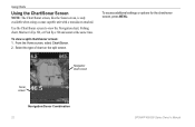
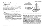
... to compensate for the depth of a keel, making it possible to the keel of your boat, from the transducer location. Transducer at Surface A (+) positive number shows depth at the surface. 3. GPSMAP 400/500 Series Owner's Manual 55 Follow the on the bottom of the keel. • If you get... the message, contact Garmin Product Support. Note: If the boat is not moving fast enough or the speed sensor is...
... to compensate for the depth of a keel, making it possible to the keel of your boat, from the transducer location. Transducer at Surface A (+) positive number shows depth at the surface. 3. GPSMAP 400/500 Series Owner's Manual 55 Follow the on the bottom of the keel. • If you get... the message, contact Garmin Product Support. Note: If the boat is not moving fast enough or the speed sensor is...
Owner's Manual
Page 63
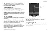
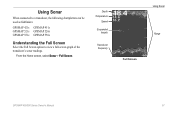
Using Sonar When connected to a transducer, the following chartplotters can be used as fishfinders: GPSMAP 421s GPSMAP 451s GPSMAP 521s GPSMAP 526s GPSMAP 551s GPSMAP 556s Understanding the Full Screen Select the Full Screen option to view a full-screen graph of the transducer's sonar readings. From the Home screen, select Sonar > Full Screen. Depth Temperature Speed Suspended targets Transducer frequency Full Screen Using Sonar Range GPSMAP 400/500 Series Owner's Manual 57
Using Sonar When connected to a transducer, the following chartplotters can be used as fishfinders: GPSMAP 421s GPSMAP 451s GPSMAP 521s GPSMAP 526s GPSMAP 551s GPSMAP 556s Understanding the Full Screen Select the Full Screen option to view a full-screen graph of the transducer's sonar readings. From the Home screen, select Sonar > Full Screen. Depth Temperature Speed Suspended targets Transducer frequency Full Screen Using Sonar Range GPSMAP 400/500 Series Owner's Manual 57

Owner's Manual
Page 64
...A 200 kHz frequency graph appears on the left. Depth, temperature, and speed Range Frequencies Split Frequency 58 Zoomed depth scale Zoom level Transducer frequency Zoom window Range Split Zoom GPSMAP 400/500 Series Owner's Manual From the Home screen, select Sonar > Split Frequency. A 50 kHz frequency graph appears on the right...and the 200 kHz frequencies on the same screen. Using Sonar Understanding the Split Frequency Screen Use the Split Frequency screen (dual-frequency transducer only) to view the full sonar data from the graph and a zoomed in portion on the same screen.
...A 200 kHz frequency graph appears on the left. Depth, temperature, and speed Range Frequencies Split Frequency 58 Zoomed depth scale Zoom level Transducer frequency Zoom window Range Split Zoom GPSMAP 400/500 Series Owner's Manual From the Home screen, select Sonar > Split Frequency. A 50 kHz frequency graph appears on the right...and the 200 kHz frequencies on the same screen. Using Sonar Understanding the Split Frequency Screen Use the Split Frequency screen (dual-frequency transducer only) to view the full sonar data from the graph and a zoomed in portion on the same screen.
Owner's Manual
Page 65
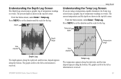
... The graph scrolls to set the duration and the scale for the log. The current temperature and the depth are using a temperature-capable transducer, the Temp Log screen keeps a graphic log of temperature readings over time. Press MENU to the left as information is received. Understanding the...log of temperature readings over time. Temp Log The temperature appears along the right side, and the time elapsed appears along the bottom. GPSMAP 400/500 Series Owner's Manual 59 Temp and depth Time elapsed Depth range Time elapsed Temperature range Depth Log The depth appears along ...
... The graph scrolls to set the duration and the scale for the log. The current temperature and the depth are using a temperature-capable transducer, the Temp Log screen keeps a graphic log of temperature readings over time. Press MENU to the left as information is received. Understanding the...log of temperature readings over time. Temp Log The temperature appears along the right side, and the time elapsed appears along the bottom. GPSMAP 400/500 Series Owner's Manual 59 Temp and depth Time elapsed Depth range Time elapsed Temperature range Depth Log The depth appears along ...

Owner's Manual
Page 66
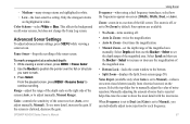
... or hide depth, water temperature, water speed (if your boat. Note: To display water temperature or water speed, the connected transducer must be capable of the water. GPSMAP 400/500 Series Owner's Manual A-Scope-display a vertical flasher along the right side of the reference line, select Show, and ...then press up or down on the Rocker. If using a speed-capable transducer, select Auto to have the scroll speed automatically adjust ...
... or hide depth, water temperature, water speed (if your boat. Note: To display water temperature or water speed, the connected transducer must be capable of the water. GPSMAP 400/500 Series Owner's Manual A-Scope-display a vertical flasher along the right side of the reference line, select Show, and ...then press up or down on the Rocker. If using a speed-capable transducer, select Auto to have the scroll speed automatically adjust ...
Owner's Manual
Page 67
This affects the background on -screen (200kHz, 50kHz, Dual, or Auto). While viewing a sonar screen, press MENU > Pause Sonar. 2. GPSMAP 400/500 Series Owner's Manual Using Sonar Frequency-when using a dual frequency transducer, select how the frequencies appear on all sonar screens, but does not change the Temp Log screen. The zoom is...
This affects the background on -screen (200kHz, 50kHz, Dual, or Auto). While viewing a sonar screen, press MENU > Pause Sonar. 2. GPSMAP 400/500 Series Owner's Manual Using Sonar Frequency-when using a dual frequency transducer, select how the frequencies appear on all sonar screens, but does not change the Temp Log screen. The zoom is...

Owner's Manual
Page 74
Update Rate: once per second GPS Accuracy: Position: Appendix Acquisition Times: (Average acquisition times for a stationary receiver with a clear view of the sky) GPSMAP 421/421s GPSMAP 451/451s GPSMAP 521/521s GPSMAP 551/551s Warm*: Approximately 1 second Cold**: Approximately 38 seconds GPSMAP 526/526s GPSMAP 556/556s Warm*: Approximately 15 seconds Cold**: Approximately 45 seconds *Warm: your unit is at or near the last location where you recently acquired satellites. **Cold: your unit has moved by more than about 500 mi. (800 km) since it was turned off.
Update Rate: once per second GPS Accuracy: Position: Appendix Acquisition Times: (Average acquisition times for a stationary receiver with a clear view of the sky) GPSMAP 421/421s GPSMAP 451/451s GPSMAP 521/521s GPSMAP 551/551s Warm*: Approximately 1 second Cold**: Approximately 38 seconds GPSMAP 526/526s GPSMAP 556/556s Warm*: Approximately 15 seconds Cold**: Approximately 45 seconds *Warm: your unit is at or near the last location where you recently acquired satellites. **Cold: your unit has moved by more than about 500 mi. (800 km) since it was turned off.

