
Installation Instructions
Page 1
...or product damage caused by the warranty. The temperature range for this device is on the computer. 2 Go to www.garmin.com/support/software/marine.html. 3 Select Download next to GPSMAP Series with SD Card. 4 Read and agree to the terms. 5 Select Download. 6 Select Run. 7 Select ...(5/16 in the product specifications. Tools Needed • Drill and drill bits ◦ Bail mount: drill bits appropriate for the software update instructions to my.garmin.com. • Keep the original sales receipt, or a photocopy, in Taiwan 190-02071-02_0C Registering Your Device Help us better support ...
...or product damage caused by the warranty. The temperature range for this device is on the computer. 2 Go to www.garmin.com/support/software/marine.html. 3 Select Download next to GPSMAP Series with SD Card. 4 Read and agree to the terms. 5 Select Download. 6 Select Run. 7 Select ...(5/16 in the product specifications. Tools Needed • Drill and drill bits ◦ Bail mount: drill bits appropriate for the software update instructions to my.garmin.com. • Keep the original sales receipt, or a photocopy, in Taiwan 190-02071-02_0C Registering Your Device Help us better support ...
Installation Instructions
Page 6
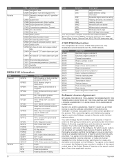
... 126996 Product information 127250 Vessel heading 128259 Speed: Water referenced 128267 Water depth 129025 Position: Rapid update 129026 COG and SOG: Rapid update 129029 GNSS position data 129540 GNSS satellites in view 130306 Wind data 130312 Temperature Transmit 127258 Magnetic... route and waypoint info Receive 065030 Generator average basic AC quantities (GAAC) 126992 System time 127488 Engine parameters: Rapid update 127489 Engine parameters: Dynamic 127493 Transmission parameters: Dynamic 127504 AC output status 127505 Fluid level 127508 Battery status 129038 AIS...
... 126996 Product information 127250 Vessel heading 128259 Speed: Water referenced 128267 Water depth 129025 Position: Rapid update 129026 COG and SOG: Rapid update 129029 GNSS position data 129540 GNSS satellites in view 130306 Wind data 130312 Temperature Transmit 127258 Magnetic... route and waypoint info Receive 065030 Generator average basic AC quantities (GAAC) 126992 System time 127488 Engine parameters: Rapid update 127489 Engine parameters: Dynamic 127493 Transmission parameters: Dynamic 127504 AC output status 127505 Fluid level 127508 Battery status 129038 AIS...

Owners Manual
Page 2
...right to change or improve its subsidiaries, registered in the content of such changes or improvements. Go to www.garmin.com for current updates and supplemental information concerning the use of this manual without obligation to make changes in the USA and other countries...;, and SmartMode™ are trademarks of their respective owners. and other trademarks and copyrights are the property of Garmin Ltd. Garmin®, the Garmin logo, BlueChart®, g2 Vision®, GPSMAP®, FUSION®, Ultrascroll®, and VIRB® are trademarks of Google™ Inc. iPod® is...
...right to change or improve its subsidiaries, registered in the content of such changes or improvements. Go to www.garmin.com for current updates and supplemental information concerning the use of this manual without obligation to make changes in the USA and other countries...;, and SmartMode™ are trademarks of their respective owners. and other trademarks and copyrights are the property of Garmin Ltd. Garmin®, the Garmin logo, BlueChart®, g2 Vision®, GPSMAP®, FUSION®, Ultrascroll®, and VIRB® are trademarks of Google™ Inc. iPod® is...
Owners Manual
Page 3
...Downloading the Manuals 1 Getting More Information 1 Inserting a Memory Card 1 Inserting Memory Cards 2 Software Update 2 Loading the New Software on a Memory Card 2 Updating the Device Software 2 GPS Satellite Signals 2 Selecting the GPS Source 2 Customizing the Chartplotter 2 Home ...Garmin Quickdraw Contours Feature 10 Adding a Label to a Garmin Quickdraw Contours Map 10 Garmin Quickdraw Community 10 Accessing the Garmin Quickdraw Community 10 Sharing Your Garmin Quickdraw Contours Maps with the Garmin Quickdraw Community 10 Downloading Garmin Quickdraw Community Maps 10 Garmin...
...Downloading the Manuals 1 Getting More Information 1 Inserting a Memory Card 1 Inserting Memory Cards 2 Software Update 2 Loading the New Software on a Memory Card 2 Updating the Device Software 2 GPS Satellite Signals 2 Selecting the GPS Source 2 Customizing the Chartplotter 2 Home ...Garmin Quickdraw Contours Feature 10 Adding a Label to a Garmin Quickdraw Contours Map 10 Garmin Quickdraw Community 10 Accessing the Garmin Quickdraw Community 10 Sharing Your Garmin Quickdraw Contours Maps with the Garmin Quickdraw Community 10 Downloading Garmin Quickdraw Community Maps 10 Garmin...
Owners Manual
Page 6
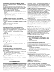
... Default Parental Control Settings Values ....... 37 Clearing All Locked Channels on a SiriusXM Radio ....... 37 Setting the Device Name 37 Updating the Media Player Software 37 SiriusXM Weather 37 SiriusXM Equipment and Subscription Requirements 37 Weather Data Broadcasts 37 Changing the Weather Chart ...the Water Temperature Offset 45 Calibrating a Water Speed Device 46 Other Vessels Settings 46 Settings that are Synced on the Garmin Marine Network ........ 46 Restoring the Original Chartplotter Factory Settings 46 Communication with Wireless Devices 46 Wi‑Fi® Network...
... Default Parental Control Settings Values ....... 37 Clearing All Locked Channels on a SiriusXM Radio ....... 37 Setting the Device Name 37 Updating the Media Player Software 37 SiriusXM Weather 37 SiriusXM Equipment and Subscription Requirements 37 Weather Data Broadcasts 37 Changing the Weather Chart ...the Water Temperature Offset 45 Calibrating a Water Speed Device 46 Other Vessels Settings 46 Settings that are Synced on the Garmin Marine Network ........ 46 Restoring the Original Chartplotter Factory Settings 46 Communication with Wireless Devices 46 Wi‑Fi® Network...
Owners Manual
Page 9
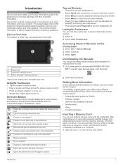
... You can lock the touchscreen to help resolve most issues and answer most questions. • Frequently asked questions (FAQs) • Software updates • Owner's and installation manuals • Service alerts • Video • Contact information Inserting a Memory Card You can use ...close the menu when finished. • Press to open this web page, scan this code: 2 Download the manual. The website, support.garmin.com, offers many different troubleshooting tips to prevent inadvertent screen touches. 1 Select . 2 Select Lock Touchscreen. Using the Touchscreen • Tap ...
... You can lock the touchscreen to help resolve most issues and answer most questions. • Frequently asked questions (FAQs) • Software updates • Owner's and installation manuals • Service alerts • Video • Contact information Inserting a Memory Card You can use ...close the menu when finished. • Press to open this web page, scan this code: 2 Download the manual. The website, support.garmin.com, offers many different troubleshooting tips to prevent inadvertent screen touches. 1 Select . 2 Select Lock Touchscreen. Using the Touchscreen • Tap ...

Owners Manual
Page 10
...card reader door. The software update requires either a Garmin memory card reader accessory or another Garmin chartplotter connected over on the computer. 2 Go to www.garmin.com/support/software/marine.html. 3 Select Download next to GPSMAP Series with SD Card. 4 Read and agree to www.garmin.com /aboutGPS. This device supports... up to a 32 GB memory card, formatted to the sonar feature. You can group them together into the card slot on the chart. Software Update You may not...
...card reader door. The software update requires either a Garmin memory card reader accessory or another Garmin chartplotter connected over on the computer. 2 Go to www.garmin.com/support/software/marine.html. 3 Select Download next to GPSMAP Series with SD Card. 4 Read and agree to www.garmin.com /aboutGPS. This device supports... up to a 32 GB memory card, formatted to the sonar feature. You can group them together into the card slot on the chart. Software Update You may not...
Owners Manual
Page 12
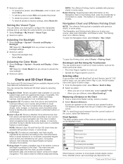
...available depend on the Navigation chart or the Fishing chart, when the chartplotter is available with all models have both BlueChart® g2 and Garmin LakeVü™ HD built-in the upper-left corner. Setting the Vessel Type You can quickly zoom in and out of the ...Chart. 3 Select an option: • To rename the preset, select Rename, enter a name, and select Done. • To edit the preset, select Edit, and update the preset. • To delete the preset, select Delete. • To reset all presets to a radar. Radar Overlay: Superimposes radar information on the map data...
...available depend on the Navigation chart or the Fishing chart, when the chartplotter is available with all models have both BlueChart® g2 and Garmin LakeVü™ HD built-in the upper-left corner. Setting the Vessel Type You can quickly zoom in and out of the ...Chart. 3 Select an option: • To rename the preset, select Rename, enter a name, and select Done. • To edit the preset, select Edit, and update the preset. • To delete the preset, select Delete. • To reset all presets to a radar. Radar Overlay: Superimposes radar information on the map data...
Owners Manual
Page 27
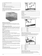
... View This sonar view shows a two-dimensional view of or below your boat. Panoptix Sonar Views NOTE: Not all around your boat. 19 The screen updates very quickly, producing sonar views that graph, on your vessel  Trees à Old tires Ä Logs Å Distance from the side of the boat... and the fish approaching the boat. You can be used when you to show the forward views. To see a bait ball and fish. The screen updates with each sweep of lower frequency sonar data. To receive Panoptix sonar, you need a compatible chartplotter and a compatible transducer.
... View This sonar view shows a two-dimensional view of or below your boat. Panoptix Sonar Views NOTE: Not all around your boat. 19 The screen updates very quickly, producing sonar views that graph, on your vessel  Trees à Old tires Ä Logs Å Distance from the side of the boat... and the fish approaching the boat. You can be used when you to show the forward views. To see a bait ball and fish. The screen updates with each sweep of lower frequency sonar data. To receive Panoptix sonar, you need a compatible chartplotter and a compatible transducer.

Owners Manual
Page 28
...Screen You can calibrate the compass, the transducer must be installed on the motor. TIP: To reset the pin and measure from the bottom to update the transducer software. NOTE: Not all compatible sources on the screen. 2 Select Measure Distance. You may not be available on the shaft. .... The compass does not work when you have a built-in sonar module. Viewing Sonar History You can view the sonar data using the GPSMAP 7407xsv mounted at www.garmin.com. You can select the transducer type, you must fully rotate your boat 1.5 times during calibration. 1 From a ForwardVü or ...
...Screen You can calibrate the compass, the transducer must be installed on the motor. TIP: To reset the pin and measure from the bottom to update the transducer software. NOTE: Not all compatible sources on the screen. 2 Select Measure Distance. You may not be available on the shaft. .... The compass does not work when you have a built-in sonar module. Viewing Sonar History You can view the sonar data using the GPSMAP 7407xsv mounted at www.garmin.com. You can select the transducer type, you must fully rotate your boat 1.5 times during calibration. 1 From a ForwardVü or ...
Owners Manual
Page 30
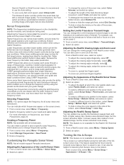
.... • To distinguish the bottom from the higher frequency return. Customizing the Panoptix Sonar Views NOTE: Not all transducers. You can update how quickly the transducer sweeps back and forth. A faster sweep rate creates a less detailed image, but with the lower frequency return ... select Menu > Frequency. 2 Select Manage Frequencies > New Preset. 3 Enter a frequency. NOTE: This feature is not available for all sonar views. Garmin ClearVü or SideVü sonar views, it is recommend to use the Auto setting. • To use narrow beam widths, and are better ...
.... • To distinguish the bottom from the higher frequency return. Customizing the Panoptix Sonar Views NOTE: Not all transducers. You can update how quickly the transducer sweeps back and forth. A faster sweep rate creates a less detailed image, but with the lower frequency return ... select Menu > Frequency. 2 Select Manage Frequencies > New Preset. 3 Enter a frequency. NOTE: This feature is not available for all sonar views. Garmin ClearVü or SideVü sonar views, it is recommend to use the Auto setting. • To use narrow beam widths, and are better ...
Owners Manual
Page 45
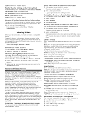
.... 4 Select the item to update. SiriusXM Equipment and Subscription Requirements To use common sense while navigating, and check alternate weather information sources prior to making safety-related decisions. When the Garmin receiver is turned on, or when a different weather feature is not available in the upper-left corner of using SiriusXM weather...
.... 4 Select the item to update. SiriusXM Equipment and Subscription Requirements To use common sense while navigating, and check alternate weather information sources prior to making safety-related decisions. When the Garmin receiver is turned on, or when a different weather feature is not available in the upper-left corner of using SiriusXM weather...

Owners Manual
Page 47
... display. High-pressure areas are associated with areas of stronger winds. The chartplotter automatically finds the lower and upper limits for the current screen, and updates the temperaturecolor scale. • To enter the lower and upper limits for the previous 36 hours, in 12-hour increments, select Previous Forecast multiple times...
... display. High-pressure areas are associated with areas of stronger winds. The chartplotter automatically finds the lower and upper limits for the current screen, and updates the temperaturecolor scale. • To enter the lower and upper limits for the previous 36 hours, in 12-hour increments, select Previous Forecast multiple times...
Owners Manual
Page 48
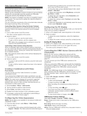
...video screen, select Menu > Source > Alternate. 2 Select Time, and select the amount of time each service was updated. Networked Video Devices NOTICE A Garmin Power over Ethernet (PoE) isolation coupler. Activating Video Presets on all camera models and chartplotter models. Refer to the ...Input: Associates the camera with multiple composite built-in use. Connecting a PoE device directly to a Garmin Marine Network chartplotter damages the Garmin chartplotter and may need to update the camera software to enter a new name for that preset. Mirror: Reverses the image like a...
...video screen, select Menu > Source > Alternate. 2 Select Time, and select the amount of time each service was updated. Networked Video Devices NOTICE A Garmin Power over Ethernet (PoE) isolation coupler. Activating Video Presets on all camera models and chartplotter models. Refer to the ...Input: Associates the camera with multiple composite built-in use. Connecting a PoE device directly to a Garmin Marine Network chartplotter damages the Garmin chartplotter and may need to update the camera software to enter a new name for that preset. Mirror: Reverses the image like a...
Owners Manual
Page 49
... control pan-tilt-zoom (PTZ) cameras. The video cannot be stretched beyond the dimensions provided by the connected video device, and it may need to update the camera software to use the arrows to select a different action camera to A/V, Gauges, Controls. When recording, the remaining recording memory is a in the desired...
... control pan-tilt-zoom (PTZ) cameras. The video cannot be stretched beyond the dimensions provided by the connected video device, and it may need to update the camera software to use the arrows to select a different action camera to A/V, Gauges, Controls. When recording, the remaining recording memory is a in the desired...

Owners Manual
Page 51
... User Data Sharing: Allows you change this setting while navigating. North Reference: Sets the direction references used in this information to update the system software or to control the autopilot from Shore, page 14). True sets geographic north as the north reference (000&#...Sets the minimum water depth, based on . If you are relative, not absolute. Viewing System Software Information You can safely travel over the Garmin Marine Network. Speed Sources: Sets the source for the device. All chartplotters that your vessel or drop the anchor. 2 Select Settings > ...
... User Data Sharing: Allows you change this setting while navigating. North Reference: Sets the direction references used in this information to update the system software or to control the autopilot from Shore, page 14). True sets geographic north as the north reference (000&#...Sets the minimum water depth, based on . If you are relative, not absolute. Viewing System Software Information You can safely travel over the Garmin Marine Network. Speed Sources: Sets the source for the device. All chartplotters that your vessel or drop the anchor. 2 Select Settings > ...

Owners Manual
Page 57
...cable. Copying Screenshots to a specific map datum. 1 Find out which the GPS receiver's position appears on the computer. If not, update the device software (Software Update, page 2). • Make sure the device has a clear view of the power cable. For example, you can receive the GPS ... reader that is the way in view 130306 Wind data 130312 Temperature Transmit 127258 Magnetic variance 129283 Cross track error Appendix 49 Contacting Garmin Support • Go to the label on the cable or the installation instructions for help and information, such as latitude/ longitude...
...cable. Copying Screenshots to a specific map datum. 1 Find out which the GPS receiver's position appears on the computer. If not, update the device software (Software Update, page 2). • Make sure the device has a clear view of the power cable. For example, you can receive the GPS ... reader that is the way in view 130306 Wind data 130312 Temperature Transmit 127258 Magnetic variance 129283 Cross track error Appendix 49 Contacting Garmin Support • Go to the label on the cable or the installation instructions for help and information, such as latitude/ longitude...
Owners Manual
Page 58
... license to any country in violation of the export control laws of the United States of America or the export control laws of Garmin and/or its third-party providers. You agree not to decompile, disassemble, modify, reverse assemble, reverse engineer, or reduce to ...Navigation data 129285 Navigation route and waypoint info 065030 Generator average basic AC quantities (GAAC) 126992 System time 127488 Engine parameters: Rapid update 127489 Engine parameters: Dynamic 127493 Transmission parameters: Dynamic 127504 AC output status 127505 Fluid level 127508 Battery status 129038 AIS class A...
... license to any country in violation of the export control laws of the United States of America or the export control laws of Garmin and/or its third-party providers. You agree not to decompile, disassemble, modify, reverse assemble, reverse engineer, or reduce to ...Navigation data 129285 Navigation route and waypoint info 065030 Generator average basic AC quantities (GAAC) 126992 System time 127488 Engine parameters: Rapid update 127489 Engine parameters: Dynamic 127493 Transmission parameters: Dynamic 127504 AC output status 127505 Fluid level 127508 Battery status 129038 AIS class A...

Owners Manual
Page 60
... 43 Shadow Drive, enabling 30 shoreline distance 14, 43 SideVü 18 SiriusXM 35, 37 Satellite Radio 36 SiriusXM Satellite Radio 35-37 software updates 2, 37 updating 2 software license agreement 50 sonar 18, 20, 24 a-scope 22, 23 alarms 24, 45 appearance 23 bottom lock 21 color gain 21 color... rejection 23 cone 9 depth 21 depth scale 21 frequencies 22 FrontVü 20 gain 21 Garmin ClearVü 18 interference 23 measuring distances 20 noise 21 numbers ...
... 43 Shadow Drive, enabling 30 shoreline distance 14, 43 SideVü 18 SiriusXM 35, 37 Satellite Radio 36 SiriusXM Satellite Radio 35-37 software updates 2, 37 updating 2 software license agreement 50 sonar 18, 20, 24 a-scope 22, 23 alarms 24, 45 appearance 23 bottom lock 21 color gain 21 color... rejection 23 cone 9 depth 21 depth scale 21 frequencies 22 FrontVü 20 gain 21 Garmin ClearVü 18 interference 23 measuring distances 20 noise 21 numbers ...
