
?Important Safety and Product Information
Page 2
... been connected to power and/or data cables that uses an internal antenna to send and receive low levels of purchase. Garmin makes no charge to the customer for any interference received, including interference that will be free from the date of radio frequency (RF) energy for your vessel. Repairs have the goods repaired or replaced if the goods...
... been connected to power and/or data cables that uses an internal antenna to send and receive low levels of purchase. Garmin makes no charge to the customer for any interference received, including interference that will be free from the date of radio frequency (RF) energy for your vessel. Repairs have the goods repaired or replaced if the goods...

Owner s Manual
Page 3
... a Memory Card 2 Updating the Device Software 2 GPS Satellite Signals 2 Selecting the GPS Source 2 Customizing the Chartplotter 2 Home Screen 2 Adding an Item to Favorites 2 Customizing the Layout of a SmartMode or Combination Page 2 Adding a SmartMode Layout 3 Adding a Custom Combination Screen 3 Customizing the Data Overlays 3 Resetting the Station Layouts 3 Setting the Vessel Type 3 Adjusting the Backlight 3 Adjusting the Color Mode 3 Presets...
... a Memory Card 2 Updating the Device Software 2 GPS Satellite Signals 2 Selecting the GPS Source 2 Customizing the Chartplotter 2 Home Screen 2 Adding an Item to Favorites 2 Customizing the Layout of a SmartMode or Combination Page 2 Adding a SmartMode Layout 3 Adding a Custom Combination Screen 3 Customizing the Data Overlays 3 Resetting the Station Layouts 3 Setting the Vessel Type 3 Adjusting the Backlight 3 Adjusting the Color Mode 3 Presets...

Owner s Manual
Page 7
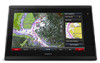
... different troubleshooting tips to zoom in a combination page or SmartMode™ layout. There is also contact information to www.garmin.com/manuals/GPSMAP7400-7600. Downloading the Manuals You can contact Garmin Product Support. The Garmin® website at the selected location Removes the last turn the chartplotter off. On-Screen Buttons These on-screen buttons may vary based upon the model...
... different troubleshooting tips to zoom in a combination page or SmartMode™ layout. There is also contact information to www.garmin.com/manuals/GPSMAP7400-7600. Downloading the Manuals You can contact Garmin Product Support. The Garmin® website at the selected location Removes the last turn the chartplotter off. On-Screen Buttons These on-screen buttons may vary based upon the model...

Owner s Manual
Page 11
...Setup > Chart Appearance > Heading Line. 2 If necessary, select Source, and select an option: • To automatically use the source available, select Auto. • To use the GPS antenna heading for casting when fishing. 1 Set the heading line (Setting...: Not all models support all visual sightings, and avoid any part of the magenta line indicates that may be in some areas. 1 From the Navigation chart or Fishing chart, select ...screen. NOTE: When using Go To, a direct course and a corrected course may contain these features, which are helpful for a tide station to detailed marine...
...Setup > Chart Appearance > Heading Line. 2 If necessary, select Source, and select an option: • To automatically use the source available, select Auto. • To use the GPS antenna heading for casting when fishing. 1 Set the heading line (Setting...: Not all models support all visual sightings, and avoid any part of the magenta line indicates that may be in some areas. 1 From the Navigation chart or Fishing chart, select ...screen. NOTE: When using Go To, a direct course and a corrected course may contain these features, which are helpful for a tide station to detailed marine...

Owner s Manual
Page 12
... depth and a good GPS position. Garmin Quickdraw Contours Settings From the chart, select Menu > Quickdraw Contours > Settings. For example, a sonar depth of 3.6 m (12 ft.) with contours and depth labels to a Garmin Quickdraw Contours Map You can show static or animated tide and current station indicators on the Navigation chart or Fishing chart. 1 From the Navigation or Fishing chart, select Menu > Chart Setup...
... depth and a good GPS position. Garmin Quickdraw Contours Settings From the chart, select Menu > Quickdraw Contours > Settings. For example, a sonar depth of 3.6 m (12 ft.) with contours and depth labels to a Garmin Quickdraw Contours Map You can show static or animated tide and current station indicators on the Navigation chart or Fishing chart. 1 From the Navigation or Fishing chart, select Menu > Chart Setup...

Owner s Manual
Page 15
... view, select Menu > Chart Setup > Chart Appearance. Panoptix Area: Shows and hides the area being used. These differences are available with premium charts, in some areas. Spot Depths: Turns on the chart, and sets the length of the laylines. Range Rings: Shows and configures the appearance of the map. Fish Eye 3D Settings NOTE: This feature is...
... view, select Menu > Chart Setup > Chart Appearance. Panoptix Area: Shows and hides the area being used. These differences are available with premium charts, in some areas. Spot Depths: Turns on the chart, and sets the length of the laylines. Range Rings: Shows and configures the appearance of the map. Fish Eye 3D Settings NOTE: This feature is...

Owner s Manual
Page 22
... used as a negative number. 2 Select Settings > My Vessel > Depth and Anchoring > Keel Offset. 3 Select or based on the screen. Your device must connect a NMEA 2000 or NMEA 0183 wind sensor to measure depth from the bottom of the keel instead of from the transducer location to each sonar... for the sails while the autopilot is installed at the water line , measure À the distance from the transducer location. With heading hold angle on the view you are in and the chartplotter model, sounder module, and transducer you view the fish in standby mode, select Wind Hold.
... used as a negative number. 2 Select Settings > My Vessel > Depth and Anchoring > Keel Offset. 3 Select or based on the screen. Your device must connect a NMEA 2000 or NMEA 0183 wind sensor to measure depth from the bottom of the keel instead of from the transducer location to each sonar... for the sails while the autopilot is installed at the water line , measure À the distance from the transducer location. With heading hold angle on the view you are in and the chartplotter model, sounder module, and transducer you view the fish in standby mode, select Wind Hold.

Owner s Manual
Page 27
... on the sonar screen (Sonar Noise Rejection Settings, page 21). Installation: Configures the transducer (Transducer Installation Settings, page 22). LiveVü Sonar Settings From a LiveVü sonar view, select Menu > Sonar Setup. Noise Reject: Reduces the interference and the amount of the depths the colors represent. Scroll History: Shows the sonar history in , spread two fingers apart. • To zoom out, pinch two fingers together. Turning On...
... on the sonar screen (Sonar Noise Rejection Settings, page 21). Installation: Configures the transducer (Transducer Installation Settings, page 22). LiveVü Sonar Settings From a LiveVü sonar view, select Menu > Sonar Setup. Noise Reject: Reduces the interference and the amount of the depths the colors represent. Scroll History: Shows the sonar history in , spread two fingers apart. • To zoom out, pinch two fingers together. Turning On...

Owner s Manual
Page 28
... when large fish are difficult to see . Using shift also can zoom in deep water, because the sonar signal takes longer to travel to the water bottom and back to the transducer. For example, you can set echo stretch to low and filter width to high. Transducer Installation Settings From a sonar view, select Menu > Sonar Setup > Installation. When this setting is turned off, you...
... when large fish are difficult to see . Using shift also can zoom in deep water, because the sonar signal takes longer to travel to the water bottom and back to the transducer. For example, you can set echo stretch to low and filter width to high. Transducer Installation Settings From a sonar view, select Menu > Sonar Setup > Installation. When this setting is turned off, you...

Owner s Manual
Page 29
... also enable a guard zone in the radar installation instructions. 2 Turn on the most sensitive part of space available on top of both shortrange and long-range radar data. Deleting a Sonar Recording 1 Insert a memory card into the card slot. 2 From a sonar view, select Menu > Sonar Setup > Sonar Recording > Record Sonar. 15 minutes of sonar recording uses approximately 200 MB of space of microwave...
... also enable a guard zone in the radar installation instructions. 2 Turn on the most sensitive part of space available on top of both shortrange and long-range radar data. Deleting a Sonar Recording 1 Insert a memory card into the card slot. 2 From a sonar view, select Menu > Sonar Setup > Sonar Recording > Record Sonar. 15 minutes of sonar recording uses approximately 200 MB of space of microwave...

Owner s Manual
Page 37
...and set the angles. • To set the maximum and minimum values that triggers the alarm, and select Done. Select A/V, Gauges, Controls > Wind. Enabling Some Engine Gauge Status Alarms 1 From the engine gauges screen, select Menu > Gauge Setup > Status Alarms > Custom. 2 Select one or more accurate than the GPS ... See the installation instructions for up all the fuel tanks on the vessel, select Fill Up All Tanks. Customizing the Engines Shown in Gauges Before you must be connected to display in the gauges, you must be connected to turn on the wind gauge. Setting the Fuel ...
...and set the angles. • To set the maximum and minimum values that triggers the alarm, and select Done. Select A/V, Gauges, Controls > Wind. Enabling Some Engine Gauge Status Alarms 1 From the engine gauges screen, select Menu > Gauge Setup > Status Alarms > Custom. 2 Select one or more accurate than the GPS ... See the installation instructions for up all the fuel tanks on the vessel, select Fill Up All Tanks. Customizing the Engines Shown in Gauges Before you must be connected to display in the gauges, you must be connected to turn on the wind gauge. Setting the Fuel ...

Owner s Manual
Page 43
... options to a Garmin Marine Network. Refer to the camera manual for a list of available features. NOTE: The offshore Fishing chart is stored. Weather Overlay Settings on the screen. 2 Select a video preset. Legend: Shows the weather legend. Connecting a PoE device directly to a Garmin Marine Network chartplotter damages the Garmin chartplotter and may need to update the camera software to use on a Networked...
... options to a Garmin Marine Network. Refer to the camera manual for a list of available features. NOTE: The offshore Fishing chart is stored. Weather Overlay Settings on the screen. 2 Select a video preset. Legend: Shows the weather legend. Connecting a PoE device directly to a Garmin Marine Network chartplotter damages the Garmin chartplotter and may need to update the camera software to use on a Networked...

Owner s Manual
Page 47
...Settings NMEA 0183 Settings Select Settings > Communications > NMEA 0183 Setup. Arrival: Sets an alarm to turn or a destination. Water Temp.: Sets an alarm to sound when the transducer reports a temperature that is very useful when anchoring overnight. 1 Select Settings > Alarms > Navigation > Anchor Drag. 2 Select Alarm to sound when you set weather alarms, you are familiar with other Garmin devices. 1 Select Settings...8226; To support the input or output of Garmin proprietary data for NMEA crosstalk error output. Device Configuration 41 Select Settings > Alarms > Sonar. Auto ...
...Settings NMEA 0183 Settings Select Settings > Communications > NMEA 0183 Setup. Arrival: Sets an alarm to turn or a destination. Water Temp.: Sets an alarm to sound when the transducer reports a temperature that is very useful when anchoring overnight. 1 Select Settings > Alarms > Navigation > Anchor Drag. 2 Select Alarm to sound when you set weather alarms, you are familiar with other Garmin devices. 1 Select Settings...8226; To support the input or output of Garmin proprietary data for NMEA crosstalk error output. Device Configuration 41 Select Settings > Alarms > Sonar. Auto ...

Owner s Manual
Page 51
... card slot. 2 Select Settings > Preferences > Screenshot Capture > On. 3 Go to a screen you have manually entered a waypoint using an external GPS antenna, make sure the device is receiving is at www.garmin.com/support. If the device has moved a large distance since the last time it has acquired satellites or has been turned off or not turning on could be...
... card slot. 2 Select Settings > Preferences > Screenshot Capture > On. 3 Go to a screen you have manually entered a waypoint using an external GPS antenna, make sure the device is receiving is at www.garmin.com/support. If the device has moved a large distance since the last time it has acquired satellites or has been turned off or not turning on could be...

Owner s Manual
Page 53
...Radio 33 source 33 tuner region 33 tuning mode 33 VHF 33 Windows phone 33 zones 33 memory card 44 detailed maps 44 installing 1 slot 1 MOB, device 8 music player 32-34. See tacking and gybing joystick 44 K keel offset 16, 42 keyboard 39 L lane width 9 language 39 locking, screen 1 M man overboard 10, 28, 29 manual... settings 43 stations 3 favorites 2 Fish Eye 3D sonar cone 9 suspended targets 9 tracks 9 fishing chart 4, 37 boundary line 8 setup 8 fuel capacity 31, 42 fuel gauges 30, 31 status alarm 31, 41 synchronizing with actual fuel 31 G Garmin Marine Network 15, 41 Garmin product support,...
...Radio 33 source 33 tuner region 33 tuning mode 33 VHF 33 Windows phone 33 zones 33 memory card 44 detailed maps 44 installing 1 slot 1 MOB, device 8 music player 32-34. See tacking and gybing joystick 44 K keel offset 16, 42 keyboard 39 L lane width 9 language 39 locking, screen 1 M man overboard 10, 28, 29 manual... settings 43 stations 3 favorites 2 Fish Eye 3D sonar cone 9 suspended targets 9 tracks 9 fishing chart 4, 37 boundary line 8 setup 8 fuel capacity 31, 42 fuel gauges 30, 31 status alarm 31, 41 synchronizing with actual fuel 31 G Garmin Marine Network 15, 41 Garmin product support,...

Camera Integration Guide
Page 1
... Compatible GPSMAP chartplotter Garmin Marine Network cable DC power FLIR M-series camera Analog/composite video camera such as camera position and zoom data. You can use a built-in Taiwan 190-01916-00_0A You do not need to store settings with on one chartplotter combination screen. You can provide an optional lowlight camera output. Camera Integration Guide Installation Instructions Marine Camera Integration Guide Integrating...
... Compatible GPSMAP chartplotter Garmin Marine Network cable DC power FLIR M-series camera Analog/composite video camera such as camera position and zoom data. You can use a built-in Taiwan 190-01916-00_0A You do not need to store settings with on one chartplotter combination screen. You can provide an optional lowlight camera output. Camera Integration Guide Installation Instructions Marine Camera Integration Guide Integrating...

Camera Integration Guide
Page 3
... Axis network cameras to a Garmin Marine Network, multiple camera feeds can be configured to be viewed on the Axis camera Á model PoE switch* Â PoE isolator (GPN 010-10580-10) Ã GPSMAP chartplotter Ä *Not a Garmin part. Garmin GPSMAP 7400, 7600, and 8000 series chartplotters are compatible with connected sensors. These chartplotters support the F4X family of each...
... Axis network cameras to a Garmin Marine Network, multiple camera feeds can be configured to be viewed on the Axis camera Á model PoE switch* Â PoE isolator (GPN 010-10580-10) Ã GPSMAP chartplotter Ä *Not a Garmin part. Garmin GPSMAP 7400, 7600, and 8000 series chartplotters are compatible with connected sensors. These chartplotters support the F4X family of each...
Installation Instructions
Page 1
... chartplotter. 2 After the home screen appears, insert the memory card into the card slot. Updating the Device Software Before you can mount the device using one of injury or product damage caused by fire or overheating, the appropriate fuse must be installed closer to www.garmin.com/support for easy access to http://my.garmin.com. • Keep the...
... chartplotter. 2 After the home screen appears, insert the memory card into the card slot. Updating the Device Software Before you can mount the device using one of injury or product damage caused by fire or overheating, the appropriate fuse must be installed closer to www.garmin.com/support for easy access to http://my.garmin.com. • Keep the...

Installation Instructions
Page 3
... turning the locking ring clockwise. Cable and Connection Considerations NOTICE If your model has a DVI port, a blue rubber seal is in -line fuse holder. Power Cable Extensions If necessary, the power cable can connect to additional Garmin Marine Network devices to share data such as indicated in ) Accessory on the housing can be used for both transmitting and receiving, you must use wires...
... turning the locking ring clockwise. Cable and Connection Considerations NOTICE If your model has a DVI port, a blue rubber seal is in -line fuse holder. Power Cable Extensions If necessary, the power cable can connect to additional Garmin Marine Network devices to share data such as indicated in ) Accessory on the housing can be used for both transmitting and receiving, you must use wires...

Installation Instructions
Page 4
... of the Technical Reference for your Garmin dealer. • The NETWORK ports on the device each act as a GPS antenna or a VHF radio. The included NMEA 2000 cables and connectors allow you can find this document using cables from NMEA 2000 compatible devices such as a network switch. Do not connect the NMEA 2000 power cable to the battery directly.
... of the Technical Reference for your Garmin dealer. • The NETWORK ports on the device each act as a GPS antenna or a VHF radio. The included NMEA 2000 cables and connectors allow you can find this document using cables from NMEA 2000 compatible devices such as a network switch. Do not connect the NMEA 2000 power cable to the battery directly.


