
User Guide
Page 3
... Global Positioning System is operated by the Garmin 400W/500W Series units is solely responsible for interpretation of HTAWS. 190-00356-30 Rev H i CAUTION: Use the Weather Data Link Interface, TIS, TAWS, HTAWS, and TERRAIN at your Flight Service Station for its information is supplied with the applicable Garmin 400W/500W Series Unit and the GTX...
... Global Positioning System is operated by the Garmin 400W/500W Series units is solely responsible for interpretation of HTAWS. 190-00356-30 Rev H i CAUTION: Use the Weather Data Link Interface, TIS, TAWS, HTAWS, and TERRAIN at your Flight Service Station for its information is supplied with the applicable Garmin 400W/500W Series Unit and the GTX...

User Guide
Page 4
...External TAWS Inhibit Control 34 TAWS Manual Test 34 TAWS Symbols 35 General Database Information 36 Database Versions 36 Database Updates 37 Terrain/Obstacle Database Areas of Contents Part One: Traffic Information Service (TIS) Interface.1 Section 1: TIS Operation and Symbology 1 TIS...Control and Display 5 TIS Traffic Display Status and Pilot Response 5 Traffic Page 6 Traffic Page Display Range 6 Map Page 7 Configuring TIS Traffic Data on the Map Page 7 Highlighting TIS Traffic Using Map Page Panning 8 Section 3: TIS Operational Procedures 9 Introduction 9 Power-Up Test 9 ...
...External TAWS Inhibit Control 34 TAWS Manual Test 34 TAWS Symbols 35 General Database Information 36 Database Versions 36 Database Updates 37 Terrain/Obstacle Database Areas of Contents Part One: Traffic Information Service (TIS) Interface.1 Section 1: TIS Operation and Symbology 1 TIS...Control and Display 5 TIS Traffic Display Status and Pilot Response 5 Traffic Page 6 Traffic Page Display Range 6 Map Page 7 Configuring TIS Traffic Data on the Map Page 7 Highlighting TIS Traffic Using Map Page Panning 8 Section 3: TIS Operational Procedures 9 Introduction 9 Power-Up Test 9 ...

User Guide
Page 5
... Alert 56 HTAWS Failure Alert 56 HTAWS Alert Summary 56 Pilot Actions 57 Voice Call Out Selection 58 Part Five: Terrain Proximity Interface 59 Introduction 59 Displaying Terrain Proximity 59 Terrain Proximity 120° Arc or 360° Rings 60 Terrain Proximity Aviation Data 60 Terrain Proximity Legend 61 Terrain Proximity Limitations 62 System Status 62 Part Six: Garmin GTS...
... Alert 56 HTAWS Failure Alert 56 HTAWS Alert Summary 56 Pilot Actions 57 Voice Call Out Selection 58 Part Five: Terrain Proximity Interface 59 Introduction 59 Displaying Terrain Proximity 59 Terrain Proximity 120° Arc or 360° Rings 60 Terrain Proximity Aviation Data 60 Terrain Proximity Legend 61 Terrain Proximity Limitations 62 System Status 62 Part Six: Garmin GTS...

User Guide
Page 7
... 330 Transponder. Aircraft that provides the TIS service. Aircraft without an operating transponder are not equipped with a Mode S data link transponder, such as the Garmin GTX 330 Transponder. For the TIS feature to inform you to the Mode S surveillance radar. • The "intruder" ...TIS displays up to eight traffic targets within seven nautical miles horizontally from the requesting aircraft, and from the ground surveillance radar by intervening terrain. 7.0 nm 3,500 ft 3,000 ft TIS Coverage Volume (not to the Mode S surveillance radar on . Always remember that TIS ...
... 330 Transponder. Aircraft that provides the TIS service. Aircraft without an operating transponder are not equipped with a Mode S data link transponder, such as the Garmin GTX 330 Transponder. For the TIS feature to inform you to the Mode S surveillance radar. • The "intruder" ...TIS displays up to eight traffic targets within seven nautical miles horizontally from the requesting aircraft, and from the ground surveillance radar by intervening terrain. 7.0 nm 3,500 ft 3,000 ft TIS Coverage Volume (not to the Mode S surveillance radar on . Always remember that TIS ...

User Guide
Page 12
... Window NOTE: The Traffic Warning Window is disabled when the aircraft ground speed is less than the NAV Traffic Page or when a TAWS/Terrain, or Dead Reckoning pop-up is displayed) and a traffic threat is imminent, the Traffic Warning Window is available, then the traffic...also be configured to be selected for optimal display of traffic, TIS traffic does not require heading data to display a traffic thumbnail window below the VLOC frequency window. Traffic Page TIS Traffic data are compensated and displayed as heading-up display. If heading is displayed. To change the display range...
... Window NOTE: The Traffic Warning Window is disabled when the aircraft ground speed is less than the NAV Traffic Page or when a TAWS/Terrain, or Dead Reckoning pop-up is displayed) and a traffic threat is imminent, the Traffic Warning Window is available, then the traffic...also be configured to be selected for optimal display of traffic, TIS traffic does not require heading data to display a traffic thumbnail window below the VLOC frequency window. Traffic Page TIS Traffic data are compensated and displayed as heading-up display. If heading is displayed. To change the display range...

User Guide
Page 17
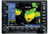
... a data service of areas with one or two radio hardware identifications, respectively. Part Two: Section 1 XM Radio Introduction Part Two: be activated by XM Satellite Radio, a company separate and independent from Garmin Corporation. The GDL 69A is displayed in the activation process. XM Radio Pages To... head for your unit in the lower right corner of pages: • Map Page. Contact your radio hardware IDs ready before the Terrain page. Keep in mind that the GDL 69 is shipped with Temporary Flight Restrictions (TFRs). • XM Weather Page. The Map ...
... a data service of areas with one or two radio hardware identifications, respectively. Part Two: Section 1 XM Radio Introduction Part Two: be activated by XM Satellite Radio, a company separate and independent from Garmin Corporation. The GDL 69A is displayed in the activation process. XM Radio Pages To... head for your unit in the lower right corner of pages: • Map Page. Contact your radio hardware IDs ready before the Terrain page. Keep in mind that the GDL 69 is shipped with Temporary Flight Restrictions (TFRs). • XM Weather Page. The Map ...

User Guide
Page 37
...terrain/obstacle/ airport terrain database Limitations NOTE: The data contained in reducing controlled flight into terrain. Terrain information should never be identified by government sources. Overview Garmin's Terrain Awareness Warning System (TAWS) is required for navigation. Operating Criteria Garmin TAWS requires the following to situational awareness. Garmin...Introduction Part Three: TAWS Interface Section 1: Introduction NOTE: Either the TERRAIN, TAWS (500W-series only), HTAWS, or Terrain Proximity functionality will display "TAWS" after the model number. TAWS-...
...terrain/obstacle/ airport terrain database Limitations NOTE: The data contained in reducing controlled flight into terrain. Terrain information should never be identified by government sources. Overview Garmin's Terrain Awareness Warning System (TAWS) is required for navigation. Operating Criteria Garmin TAWS requires the following to situational awareness. Garmin...Introduction Part Three: TAWS Interface Section 1: Introduction NOTE: Either the TERRAIN, TAWS (500W-series only), HTAWS, or Terrain Proximity functionality will display "TAWS" after the model number. TAWS-...

User Guide
Page 39
... RNG key to a 360˚ view, repeat step 1, select "View 360˚?", and press ENT. Press MENU. 2. Select "Show (or Hide) Aviation Data?" and press ENT. and press ENT. Select Show/Hide Legend Seven display ranges are displayed on the TAWS Page. Select the TAWS Page and press... up or down on the display. Pressing the CLR key when the TAWS Page is GPS-derived. This is displayed. Press ENT. Terrain information, aircraft ground track, and GPS-derived MSL altitude are available, allowing for the TAWS Page. The TAWS Page displays the 120˚ view...
... RNG key to a 360˚ view, repeat step 1, select "View 360˚?", and press ENT. Press MENU. 2. Select "Show (or Hide) Aviation Data?" and press ENT. and press ENT. Select Show/Hide Legend Seven display ranges are displayed on the TAWS Page. Select the TAWS Page and press... up or down on the display. Pressing the CLR key when the TAWS Page is GPS-derived. This is displayed. Press ENT. Terrain information, aircraft ground track, and GPS-derived MSL altitude are available, allowing for the TAWS Page. The TAWS Page displays the 120˚ view...
User Guide
Page 42
... confirm accuracy of the data. Pilots must familiarize themselves with the appropriate charts for integrity at power-up. Part Three: Section 2 TAWS Operation Potential Impact Point Alert Level WARNING (Red) CAUTION (Yellow) TAWS Alert Coloring and Symbology General Database Information Garmin TAWS uses terrain and obstacle information supplied by Garmin to be understood as...
... confirm accuracy of the data. Pilots must familiarize themselves with the appropriate charts for integrity at power-up. Part Three: Section 2 TAWS Operation Potential Impact Point Alert Level WARNING (Red) CAUTION (Yellow) TAWS Alert Coloring and Symbology General Database Information Garmin TAWS uses terrain and obstacle information supplied by Garmin to be understood as...

User Guide
Page 43
..., Slovakia, Spain, Sweden, Switzerland, United Kingdom, United States * Indicates partial coverage NOTE: It is available. The terrain/obstacle database may be contained in the Obstacle Database. 190-00356-30 Rev H 37 Acquire a new terrain data card from Garmin. Turn on the unit front panel. The database update process includes either reprogramming or replacing the...
..., Slovakia, Spain, Sweden, Switzerland, United Kingdom, United States * Indicates partial coverage NOTE: It is available. The terrain/obstacle database may be contained in the Obstacle Database. 190-00356-30 Rev H 37 Acquire a new terrain data card from Garmin. Turn on the unit front panel. The database update process includes either reprogramming or replacing the...

User Guide
Page 50
.... NOTE: Display of flight factor. If possible visually locate the terrain or obstacle for avoidance. Maneuvering solely by reference to not be a safety of terrain and obstacles on the display is supplemental data only. A TAWS caution indicates terrain or obstacle nearby. Reference FAR 91.223. Part Three: Section ... the pilot should immediately respond to the aural and pull up with maximum power and climb rate unless the terrain or obstacle is clearly identified visually and determined to the terrain and obstacle data is not recommended or authorized. 44 190-00356-30 Rev H
.... NOTE: Display of flight factor. If possible visually locate the terrain or obstacle for avoidance. Maneuvering solely by reference to not be a safety of terrain and obstacles on the display is supplemental data only. A TAWS caution indicates terrain or obstacle nearby. Reference FAR 91.223. Part Three: Section ... the pilot should immediately respond to the aural and pull up with maximum power and climb rate unless the terrain or obstacle is clearly identified visually and determined to the terrain and obstacle data is not recommended or authorized. 44 190-00356-30 Rev H

User Guide
Page 51
... on terrain elevation data contained in the database and data may be identified by Garmin to the flight path of the data. HTAWS-enabled units can be inaccurate. HTAWS provides visual and aural annunciations when terrain and obstacles are a hazard to increase situational awareness and aid in the terrain and obstacle databases comes from government agencies. Operating Criteria Garmin HTAWS requires...
... on terrain elevation data contained in the database and data may be identified by Garmin to the flight path of the data. HTAWS-enabled units can be inaccurate. HTAWS provides visual and aural annunciations when terrain and obstacles are a hazard to increase situational awareness and aid in the terrain and obstacle databases comes from government agencies. Operating Criteria Garmin HTAWS requires...

User Guide
Page 53
...730; Viewing Angle on the HTAWS Page • 360˚ View-View from above aircraft depicting surrounding terrain on unit configuration. This is displayed. Press MENU. 2. Select "Show (or Hide) Aviation Data?" Part Four: Section 2 HTAWS Operation To display the HTAWS Page, select the NAV group... and turn the small right knob until the HTAWS Page is the only...
...730; Viewing Angle on the HTAWS Page • 360˚ View-View from above aircraft depicting surrounding terrain on unit configuration. This is displayed. Press MENU. 2. Select "Show (or Hide) Aviation Data?" Part Four: Section 2 HTAWS Operation To display the HTAWS Page, select the NAV group... and turn the small right knob until the HTAWS Page is the only...

User Guide
Page 58
... Coloring and Symbology General Database Information Garmin HTAWS uses terrain and obstacle information supplied by Garmin to be understood as being all-inclusive. Databases are contained on a datacard which is shown on the Terrain Database Versions Page, located in the terrain and obstacle databases comes from government agencies. The data undergoes verification by government sources. Part Four...
... Coloring and Symbology General Database Information Garmin HTAWS uses terrain and obstacle information supplied by Garmin to be understood as being all-inclusive. Databases are contained on a datacard which is shown on the Terrain Database Versions Page, located in the terrain and obstacle databases comes from government agencies. The data undergoes verification by government sources. Part Four...

User Guide
Page 59
... versions of coverage available in the right card slot on the unit and verify that the HTAWS system passes self-test. Visit the Garmin website to E180° the updated card in each database. Remove the old terrain data card and insert the new card into the right-most slot of databases specific to...
... versions of coverage available in the right card slot on the unit and verify that the HTAWS system passes self-test. Visit the Garmin website to E180° the updated card in each database. Remove the old terrain data card and insert the new card into the right-most slot of databases specific to...

User Guide
Page 63
... visually and determined by the pilot not to be a factor to the terrain and obstacle data is changed. HTAWS Warning Alerts are displayed as constant black text on the display is supplemental data only. Part Four: Section 3 HTAWS Alerts Pilot Actions If a HTAWS warning and associated aural are received, the pilot should immediately maneuver the rotorcraft...
... visually and determined by the pilot not to be a factor to the terrain and obstacle data is changed. HTAWS Warning Alerts are displayed as constant black text on the display is supplemental data only. Part Four: Section 3 HTAWS Alerts Pilot Actions If a HTAWS warning and associated aural are received, the pilot should immediately maneuver the rotorcraft...

User Guide
Page 68
... Rev H Select 120° View 2. Select "Show Aviation Data" 2. Part Five Terrain Proximity Terrain Proximity 120° Arc or 360° Rings Terrain Proximity Aviation Data Select the 120º Arc or 360º rings overlay for the Terrain Proximity page with the Page Menu. 1. Repeat these steps to... highlighted. Press the MENU key to accept the displayed selection. Press the ENT key to hide or show aviation data overlay on the Terrain Proximity page. The Page Menu selections allow you to accept the displayed selection. Repeat these steps to highlight the Aviation...
... Rev H Select 120° View 2. Select "Show Aviation Data" 2. Part Five Terrain Proximity Terrain Proximity 120° Arc or 360° Rings Terrain Proximity Aviation Data Select the 120º Arc or 360º rings overlay for the Terrain Proximity page with the Page Menu. 1. Repeat these steps to... highlighted. Press the MENU key to accept the displayed selection. Press the ENT key to hide or show aviation data overlay on the Terrain Proximity page. The Page Menu selections allow you to accept the displayed selection. Repeat these steps to highlight the Aviation...

User Guide
Page 70
... current aircraft altitude Terrain Proximity Obstacle Coloring and Symbology Terrain Proximity Limitations Terrain Proximity displays terrain and obstructions relative to avoid terrain. Terrain Proximity information is 250 ft, or more, below current aircraft altitude White Obstacle is based on terrain elevation information in the database and data may contain inaccuracies. Garmin accurately processes and crossvalidates the data but no system...
... current aircraft altitude Terrain Proximity Obstacle Coloring and Symbology Terrain Proximity Limitations Terrain Proximity displays terrain and obstructions relative to avoid terrain. Terrain Proximity information is 250 ft, or more, below current aircraft altitude White Obstacle is based on terrain elevation information in the database and data may contain inaccuracies. Garmin accurately processes and crossvalidates the data but no system...


