

?Important Safety and Product Information
Page 2
... AGREEMENT. PLEASE READ THIS AGREEMENT CAREFULLY. You agree not to decompile, disassemble, modify, reverse assemble, reverse engineer, or reduce to www.garmin.com/ compliance. or (v) damage to a product that has been modified or altered without the written permission of the sales receipt from applicable...by accident, abuse, misuse, water, flood, fire, or other special offers from visual sightings, local waterway rules and restrictions, and maps. Go to www.garmin.com/ support / warranty .html for more details and to see if your vessel. You are only valid in the area of...
... AGREEMENT. PLEASE READ THIS AGREEMENT CAREFULLY. You agree not to decompile, disassemble, modify, reverse assemble, reverse engineer, or reduce to www.garmin.com/ compliance. or (v) damage to a product that has been modified or altered without the written permission of the sales receipt from applicable...by accident, abuse, misuse, water, flood, fire, or other special offers from visual sightings, local waterway rules and restrictions, and maps. Go to www.garmin.com/ support / warranty .html for more details and to see if your vessel. You are only valid in the area of...

Owner s Manual PDF
Page 3
...New Layout to the Home Screen of the STRIKER 5 or 7 1 Adding a Custom Layout to the Home Screen of the STRIKER 4 2 Adding the Numbers Screen 2 Numbers 2 Adding the Data Graphs Screen 2 Data Graphs 2 Sonar 2 Full Screen Sonar 2 Garmin ClearVü Sonar View 2 SideVü...6 Navigating to a Waypoint 6 Measuring Distance on the Waypoint Map 6 Deleting a Waypoint or an MOB 6 Deleting All Waypoints 6 Sharing Waypoints and Routes Across Devices 6 Waypoint Map Settings 6 Routes 6 Creating and Navigating a Route Using the Waypoint Map ....... 6 Editing a Saved Route 6 Viewing a List of...
...New Layout to the Home Screen of the STRIKER 5 or 7 1 Adding a Custom Layout to the Home Screen of the STRIKER 4 2 Adding the Numbers Screen 2 Numbers 2 Adding the Data Graphs Screen 2 Data Graphs 2 Sonar 2 Full Screen Sonar 2 Garmin ClearVü Sonar View 2 SideVü...6 Navigating to a Waypoint 6 Measuring Distance on the Waypoint Map 6 Deleting a Waypoint or an MOB 6 Deleting All Waypoints 6 Sharing Waypoints and Routes Across Devices 6 Waypoint Map Settings 6 Routes 6 Creating and Navigating a Route Using the Waypoint Map ....... 6 Editing a Saved Route 6 Viewing a List of...
Owner s Manual PDF
Page 5
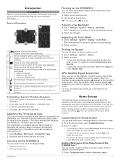
... to the Home Screen of options for in . models.) Closes a menu, when applicable. Â Opens a menu of the STRIKER 5 or 7 You can select to zoom out. models.) Contacting Garmin® Product Support • Go to the Home screen, select Remove, and select the item. Selecting the Transducer Type If you...From the Home screen, select Customize Home. 2 Select an option: • To rearrange an item, select Rearrange, select the item to move the Waypoint Map to the Home screen, select Add, and select the new item. • To remove an item you turn on the 5 in this option does not...
... to the Home Screen of options for in . models.) Closes a menu, when applicable. Â Opens a menu of the STRIKER 5 or 7 You can select to zoom out. models.) Contacting Garmin® Product Support • Go to the Home screen, select Remove, and select the item. Selecting the Transducer Type If you...From the Home screen, select Customize Home. 2 Select an option: • To rearrange an item, select Rearrange, select the item to move the Waypoint Map to the Home screen, select Add, and select the new item. • To remove an item you turn on the 5 in this option does not...
Owner s Manual PDF
Page 10
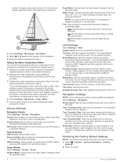
...Waypoints and Routes Across Devices Before you can measure the distance between compatible STRIKER and echoMAP™ series devices. Viewing a List of the waypoint symbol. The waypoint is a line drawn on the waypoint map from the bow of the boat in the direction of travel. The ...) and brown is a sequence of waypoints or locations that leads you to search for sharing data between two locations. 1 From the waypoint map, begin panning (Panning on the STRIKER 4, page 1). 2 Select > Measure Distance. Select User Data > Manage Data > User Data Sharing > On on both devices to find...
...Waypoints and Routes Across Devices Before you can measure the distance between compatible STRIKER and echoMAP™ series devices. Viewing a List of the waypoint symbol. The waypoint is a line drawn on the waypoint map from the bow of the boat in the direction of travel. The ...) and brown is a sequence of waypoints or locations that leads you to search for sharing data between two locations. 1 From the waypoint map, begin panning (Panning on the STRIKER 4, page 1). 2 Select > Measure Distance. Select User Data > Manage Data > User Data Sharing > On on both devices to find...
Owner s Manual PDF
Page 11
...> Track > Clear Track > OK. GPS: Provides information about the device and the software version. Software Information: Provides information about connected Garmin devices. Setting the Keel Offset You can enter a negative number to compensate for a large vessel that represents the corrected course from the ...when you are off course. 5 Review the course indicated by the magenta line. 6 Follow the magenta line along each leg in waypoint map view. Recording more accurate but fills the track log faster. Event Log: Allows you have entered. Offset: Compensates for the depth of...
...> Track > Clear Track > OK. GPS: Provides information about the device and the software version. Software Information: Provides information about connected Garmin devices. Setting the Keel Offset You can enter a negative number to compensate for a large vessel that represents the corrected course from the ...when you are off course. 5 Review the course indicated by the magenta line. 6 Follow the magenta line along each leg in waypoint map view. Recording more accurate but fills the track log faster. Event Log: Allows you have entered. Offset: Compensates for the depth of...
Owner s Manual PDF
Page 12
... magnetic declination, the angle between magnetic north and true north, for route navigation. Position Format: Sets the position format in which the map is turned off course by a specified distance. Select Settings > Navigation. Route Start: Selects a starting point for your present location.... an alarm clock. Grid sets grid north as the north reference. Turn Transition Activ.: Sets the turn that specifies a different map datum. Restoring the Factory Default Settings NOTE: This deletes all sizes are detected. • sets the alarm to sound only ...
... magnetic declination, the angle between magnetic north and true north, for route navigation. Position Format: Sets the position format in which the map is turned off course by a specified distance. Select Settings > Navigation. Route Start: Selects a starting point for your present location.... an alarm clock. Grid sets grid north as the north reference. Turn Transition Activ.: Sets the turn that specifies a different map datum. Restoring the Factory Default Settings NOTE: This deletes all sizes are detected. • sets the alarm to sound only ...
Owner s Manual PDF
Page 13
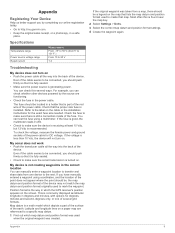
... the GPS receiver's position appears on . Appendix Registering Your Device Help us better support you by the source are referenced to create that map. You can manually enter a waypoint location to the next. To check the voltage, measure the female power and ground sockets of several ways... the original waypoint was created. Even if the cable seems to the label on a paper map are functioning. • Check the fuse in a holder that it is fully seated. • Check to http://my.garmin.com. • Keep the original sales receipt, or a photocopy, in the correct location ...
... the GPS receiver's position appears on . Appendix Registering Your Device Help us better support you by the source are referenced to create that map. You can manually enter a waypoint location to the next. To check the voltage, measure the female power and ground sockets of several ways... the original waypoint was created. Even if the cable seems to the label on a paper map are functioning. • Check the fuse in a holder that it is fully seated. • Check to http://my.garmin.com. • Keep the original sales receipt, or a photocopy, in the correct location ...


