
Quick Reference Guide
Page 1
...create a new waypoint: 1. From the Home screen, select Charts > Navigation Chart. 2. Press SELECT. 4. Select the waypoint attribute you want to use the map pointer ( ) to highlight the waypoint on the Navigation chart: 1. To delete a waypoint or an MOB: 1. Select Review > Delete (The Review button ... waypoint you want to the location, select the location > Navigate To > Go To. To go to designate as an MOB: 1. Use the map pointer ( ) to select the location you want to save the waypoint, or select Man Overboard to delete. 3. From the Home screen, select...
...create a new waypoint: 1. From the Home screen, select Charts > Navigation Chart. 2. Press SELECT. 4. Select the waypoint attribute you want to use the map pointer ( ) to highlight the waypoint on the Navigation chart: 1. To delete a waypoint or an MOB: 1. Select Review > Delete (The Review button ... waypoint you want to the location, select the location > Navigate To > Go To. To go to designate as an MOB: 1. Use the map pointer ( ) to select the location you want to save the waypoint, or select Man Overboard to delete. 3. From the Home screen, select...

Quick Reference Guide
Page 2
...position icon displays a flashing question mark. Press and release the Power key. 2. RANGE (-/+)-Press to adjust the range of the current map display, the screen scrolls forward to edit the route turns. Repeat until the route is cleared; Select MENU to the Home screen. ...turn , or to edit. 3. From the Home screen, select Information > User Data > Routes. 2. Home Screen Please visit www.garmin.com for product warnings and other areas on the map. To create a route in Taiwan When the Warning screen appears, select I Agree to be recorded. © 2009...
...position icon displays a flashing question mark. Press and release the Power key. 2. RANGE (-/+)-Press to adjust the range of the current map display, the screen scrolls forward to edit the route turns. Repeat until the route is cleared; Select MENU to the Home screen. ...turn , or to edit. 3. From the Home screen, select Information > User Data > Routes. 2. Home Screen Please visit www.garmin.com for product warnings and other areas on the map. To create a route in Taiwan When the Warning screen appears, select I Agree to be recorded. © 2009...

Important Safety and Product Information
Page 2
...Use this product is moving could result in an accident or collision resulting in death or serious injury. Declaration of Conformity Hereby, Garmin, declares that this unit only as safe for any discrepancies or questions before reuse. Industry Canada Compliance Note: The following potentially...a reasonable cost. NOTE: Refer to your product's owner's manual to determine if your product contains or accepts maps, or to www.garmin.com/compliance. Important Information Map Data Information: One of the goals of Conformity, go to determine if your product has video input capability....
...Use this product is moving could result in an accident or collision resulting in death or serious injury. Declaration of Conformity Hereby, Garmin, declares that this unit only as safe for any discrepancies or questions before reuse. Industry Canada Compliance Note: The following potentially...a reasonable cost. NOTE: Refer to your product's owner's manual to determine if your product contains or accepts maps, or to www.garmin.com/compliance. Important Information Map Data Information: One of the goals of Conformity, go to determine if your product has video input capability....

Important Safety and Product Information
Page 3
... interference that may cause undesired operation of the following conditions: (1) this device may not cause harmful interference, and (2) this period, Garmin will, at no charge to the customer for parts or labor, provided that are more reasonable protection against harmful interference in a residential... no warranty as batteries, unless product damage has occurred due to a product that interference will be free from the date of map data in a particular installation. These limits are designed to radio or television reception, which can radiate radio frequency energy and may...
... interference that may cause undesired operation of the following conditions: (1) this device may not cause harmful interference, and (2) this period, Garmin will, at no charge to the customer for parts or labor, provided that are more reasonable protection against harmful interference in a residential... no warranty as batteries, unless product damage has occurred due to a product that interference will be free from the date of map data in a particular installation. These limits are designed to radio or television reception, which can radiate radio frequency energy and may...

Chartplotter Configuration Guide for Mercury Zeus and Axius Systems
Page 2
...N/A N/A White/Blue Blue/White For the latest free software updates (excluding map data) throughout the life of what you may encounter when wiring your Garmin products, visit the Garmin Web site at www.garmin.com. B Printed in Taiwan NMEA 0183 Wiring Diagram The following wiring diagram... GPSMAP 4000/5000, or GPSMAP 6000/7000. or its subsidiaries Garmin International, Inc. 1200 East 151st Street, Olathe, Kansas 66062, USA Garmin (Europe) Ltd. Liberty House, Hounsdown Business Park, Southampton, Hampshire, SO40 9LR UK Garmin Corporation No. 68, Zhangshu 2nd Road, Xizhi Dist., New Taipei...
...N/A N/A White/Blue Blue/White For the latest free software updates (excluding map data) throughout the life of what you may encounter when wiring your Garmin products, visit the Garmin Web site at www.garmin.com. B Printed in Taiwan NMEA 0183 Wiring Diagram The following wiring diagram... GPSMAP 4000/5000, or GPSMAP 6000/7000. or its subsidiaries Garmin International, Inc. 1200 East 151st Street, Olathe, Kansas 66062, USA Garmin (Europe) Ltd. Liberty House, Hounsdown Business Park, Southampton, Hampshire, SO40 9LR UK Garmin Corporation No. 68, Zhangshu 2nd Road, Xizhi Dist., New Taipei...

Installation Instructions
Page 12
... any purpose without obligation to make changes in this and other Garmin products. or its subsidiaries Garmin International, Inc. 1200 East 151st Street, Olathe, Kansas 66062, USA Garmin (Europe) Ltd. For the latest free software updates (excluding map data) throughout the life of Garmin. Except as expressly provided herein, no part of this manual may...
... any purpose without obligation to make changes in this and other Garmin products. or its subsidiaries Garmin International, Inc. 1200 East 151st Street, Olathe, Kansas 66062, USA Garmin (Europe) Ltd. For the latest free software updates (excluding map data) throughout the life of Garmin. Except as expressly provided herein, no part of this manual may...

Owner's Manual
Page 12
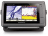
... to transfer waypoints from any screen to return to the most-current version by clicking Help > Check for Software Updates, or check the Garmin Web site at www.garmin.com. Note: You must have an "s" series unit (such as a GPSMAP 526s) with a connected transducer to use sonar features. • ... settings (page 48). 6 GPSMAP 400/500 Series Owner's Manual Understanding the Home Screen Use the Home screen to view a chart and sonar in map supports Fishing charts. • Sonar-set up and access sonar information (page 57). Getting Started Note: If you use a BlueChart g2 Vision SD card...
... to transfer waypoints from any screen to return to the most-current version by clicking Help > Check for Software Updates, or check the Garmin Web site at www.garmin.com. Note: You must have an "s" series unit (such as a GPSMAP 526s) with a connected transducer to use sonar features. • ... settings (page 48). 6 GPSMAP 400/500 Series Owner's Manual Understanding the Home Screen Use the Home screen to view a chart and sonar in map supports Fishing charts. • Sonar-set up and access sonar information (page 57). Getting Started Note: If you use a BlueChart g2 Vision SD card...

Owner's Manual
Page 13
To access a Navigation chart, from above and behind the boat (according to your course, to view map information, and as a three-dimensional navigation aid. This chart works well for either the USA shoreline or a specific country. • Navigation Chart-...Eye 3D-provides an underwater 3D view that visually represents the sea floor according to the information on your preloaded maps, including buoys, lights, cables, depth soundings, marinas, and tide stations, in map supports Fishing charts. • Fishing Chart-provides a view of the Navigation chart at the same time. ...
To access a Navigation chart, from above and behind the boat (according to your course, to view map information, and as a three-dimensional navigation aid. This chart works well for either the USA shoreline or a specific country. • Navigation Chart-...Eye 3D-provides an underwater 3D view that visually represents the sea floor according to the information on your preloaded maps, including buoys, lights, cables, depth soundings, marinas, and tide stations, in map supports Fishing charts. • Fishing Chart-provides a view of the Navigation chart at the same time. ...
Owner's Manual
Page 14
Full Screen Map-view the Navigation or Fishing chart in fullscreen mode, without numbers. Using Charts Your boat Exposed wreck Light Exposed rock Tide station Beacon Marina services ...
Full Screen Map-view the Navigation or Fishing chart in fullscreen mode, without numbers. Using Charts Your boat Exposed wreck Light Exposed rock Tide station Beacon Marina services ...

Owner's Manual
Page 15
... data bar displays Waypoint VMG when you turn off . Understanding Chart Data Charts for BlueChart g2 and BlueChart g2 Vision use graphic symbols to denote map features that shows the bearing to show on the cruising data bar. • Fishing-turn the Depth, Water Temperature, and Water Speed data bar on...
... data bar displays Waypoint VMG when you turn off . Understanding Chart Data Charts for BlueChart g2 and BlueChart g2 Vision use graphic symbols to denote map features that shows the bearing to show on the cruising data bar. • Fishing-turn the Depth, Water Temperature, and Water Speed data bar on...

Owner's Manual
Page 16
... Navigation chart. Follow the colored line on the chart, see page 26. Select Navigation Chart, Fishing Chart, or Split Navigation Chart. 3. As you move the map pointer ( ) away from your current location and to scroll to other areas on the chart to which you pan past the edge of the current... map display, the screen scrolls forward to provide continuous map coverage. Select Navigate To. 6. To pan the map, press up, down, right, or left on the Chart 1. Navigating to a Point on the Rocker. From ...
... Navigation chart. Follow the colored line on the chart, see page 26. Select Navigation Chart, Fishing Chart, or Split Navigation Chart. 3. As you move the map pointer ( ) away from your current location and to scroll to other areas on the chart to which you pan past the edge of the current... map display, the screen scrolls forward to provide continuous map coverage. Select Navigate To. 6. To pan the map, press up, down, right, or left on the Chart 1. Navigating to a Point on the Rocker. From ...

Owner's Manual
Page 17
...-station information appears on or off . Tides/Currents-turns tides and currents on the chart with the map pointer, and press SELECT. Service Points-turns marine service points on -screen map items, waypoints, and charts. If more information about on or off (page 36). Photos-sets the... ( ), and press SELECT. You can view an in the area, select Review, and then select the item. Accessing Additional Object Information Use the map pointer ( ) to view information about tides, see page 37. Selected item 2. Select the item. For more than one item is only available while...
...-station information appears on or off . Tides/Currents-turns tides and currents on the chart with the map pointer, and press SELECT. Service Points-turns marine service points on -screen map items, waypoints, and charts. If more information about on or off (page 36). Photos-sets the... ( ), and press SELECT. You can view an in the area, select Review, and then select the item. Accessing Additional Object Information Use the map pointer ( ) to view information about tides, see page 37. Selected item 2. Select the item. For more than one item is only available while...

Owner's Manual
Page 18
... zoom levels. Orientation-changes the perspective of the map display. • North Up-sets the top of detail shown on the Rocker to increase map detail. Detail-adjusts the amount of the map display to a north heading. • Head Up-sets the map display to a compatible marine wind sensor. •...; Course Up-sets the map so the direction of navigation is connected to the ...
... zoom levels. Orientation-changes the perspective of the map display. • North Up-sets the top of detail shown on the Rocker to increase map detail. Detail-adjusts the amount of the map display to a north heading. • Head Up-sets the map display to a compatible marine wind sensor. •...; Course Up-sets the map so the direction of navigation is connected to the ...

Owner's Manual
Page 19
... satellite imagery (when Full World Map is visible on or off , and sets a dangerous depth. Areas on the chart with ...8226; Chart Borders-turns chart borders on when using a BlueChart g2 Vision SD card and you want to see what area the maps cover. • Photo Points-turns camera icons (page 20) on or off . Safety Shading (only available when you to...in white. Using Charts Symbols-changes symbol preferences. • Navaid Size-adjusts the size of the navaid symbols shown on the map. • Navaid Type-selects the navaid symbol set (NOAA or IALA). • Land POIs-turns the display of land...
... satellite imagery (when Full World Map is visible on or off , and sets a dangerous depth. Areas on the chart with ...8226; Chart Borders-turns chart borders on when using a BlueChart g2 Vision SD card and you want to see what area the maps cover. • Photo Points-turns camera icons (page 20) on or off . Safety Shading (only available when you to...in white. Using Charts Symbols-changes symbol preferences. • Navaid Size-adjusts the size of the navaid symbols shown on the map. • Navaid Type-selects the navaid symbol set (NOAA or IALA). • Land POIs-turns the display of land...
Owner's Manual
Page 24
...8. While viewing the Navigation chart, press MENU. 2. From the Home screen, select Charts > Fishing Chart. For settings and options related to Full Screen Map, Waypoints & Tracks, Other Vessels, and Data Bars, see "Navigation Chart Menu" on a preprogrammed BlueChart g2 Vision SD card, and is shown on...options from the Fishing chart, press MENU. To customize the appearance of the following: • Off-standard chart information is shown on the map. • Land Only-standard chart information is best for offshore deep-sea fishing. Select one of the Fishing Chart screen, select MENU >...
...8. While viewing the Navigation chart, press MENU. 2. From the Home screen, select Charts > Fishing Chart. For settings and options related to Full Screen Map, Waypoints & Tracks, Other Vessels, and Data Bars, see "Navigation Chart Menu" on a preprogrammed BlueChart g2 Vision SD card, and is shown on...options from the Fishing chart, press MENU. To customize the appearance of the following: • Off-standard chart information is shown on the map. • Land Only-standard chart information is best for offshore deep-sea fishing. Select one of the Fishing Chart screen, select MENU >...

Owner's Manual
Page 26
You must be available in your preloaded map or BlueChart g2 Vision region. An indicator for the Tides/Currents setting (page 11). Using Charts To access aerial photos from the Navigation chart: Use ...
You must be available in your preloaded map or BlueChart g2 Vision region. An indicator for the Tides/Currents setting (page 11). Using Charts To access aerial photos from the Navigation chart: Use ...

Owner's Manual
Page 31
... only shown when more than one of the following: • Enter Coordinates-enter the grid coordinates of the new waypoint. • Use Chart-use the map pointer ( ) to cancel the move the waypoint on the Navigation chart. 2. To move . To mark your present location. OR From the Home screen, select Information...
... only shown when more than one of the following: • Enter Coordinates-enter the grid coordinates of the new waypoint. • Use Chart-use the map pointer ( ) to cancel the move the waypoint on the Navigation chart. 2. To move . To mark your present location. OR From the Home screen, select Information...

Owner's Manual
Page 32
...(page 38), chart notes, or local services information near the cursor. To view and sort or filter a list of the screen. Use the map pointer ( ) to select the location at the cursor location. • Select Information to highlight the waypoint on the Navigation chart: 1. From ...the Navigation chart, use the map pointer ( ) to make the last turn toward your present location: 1. Select an option. • Select Review or the name of the waypoint...
...(page 38), chart notes, or local services information near the cursor. To view and sort or filter a list of the screen. Use the map pointer ( ) to select the location at the cursor location. • Select Information to highlight the waypoint on the Navigation chart: 1. From ...the Navigation chart, use the map pointer ( ) to make the last turn toward your present location: 1. Select an option. • Select Review or the name of the waypoint...

Owner's Manual
Page 33
... the new route. From the Navigation chart, select your destination. 2. Select Navigate To > Guide To. NOTE: You can edit the route name or use the map pointer ( ) to select the initial location at which you to trace it while creating a route. The automatic guidance path stays on the route. From the...
... the new route. From the Navigation chart, select your destination. 2. Select Navigate To > Guide To. NOTE: You can edit the route name or use the map pointer ( ) to select the initial location at which you to trace it while creating a route. The automatic guidance path stays on the route. From the...
Owner's Manual
Page 46
... network. Existing data is combined with an .ADM extension. From the Home screen, select Information > User Data > Data Transfer > Copy Built-In Map to an SD card: 1. Unique data is overwritten on every chartplotter. From the Home screen, select Information > User Data > Data Transfer. 3. ... tracks to a computer: 1. To back up data to the SD card. Viewing Information To transfer data (waypoints, routes, tracks) to copy the maps loaded onto your chartplotter. 4. Enter the file name using the Rocker, and select Done. 4. Select the file name from an SD card: 1. ...
... network. Existing data is combined with an .ADM extension. From the Home screen, select Information > User Data > Data Transfer > Copy Built-In Map to an SD card: 1. Unique data is overwritten on every chartplotter. From the Home screen, select Information > User Data > Data Transfer. 3. ... tracks to a computer: 1. To back up data to the SD card. Viewing Information To transfer data (waypoints, routes, tracks) to copy the maps loaded onto your chartplotter. 4. Enter the file name using the Rocker, and select Done. 4. Select the file name from an SD card: 1. ...


