User Manual
Page 3
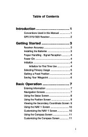
Table of Contents Introduction 1 Conventions Used in this Manual 1 GPS 315/320 Receiver 2 Getting Started 3 Receiver Accuracy 3 Installing the Batteries 3 Proper Handling - Signal Reception 4 Power On 4 Initialize 4 Initialize for First Time Use 4 Selecting Primary Usage 5 Getting a Fixed Position 6 Saving Your Waypoint 6 Basic Operation 7 Entering Information 7 Navigation Screens 7 Using the Status Screen 8 Using the Position...
Table of Contents Introduction 1 Conventions Used in this Manual 1 GPS 315/320 Receiver 2 Getting Started 3 Receiver Accuracy 3 Installing the Batteries 3 Proper Handling - Signal Reception 4 Power On 4 Initialize 4 Initialize for First Time Use 4 Selecting Primary Usage 5 Getting a Fixed Position 6 Saving Your Waypoint 6 Basic Operation 7 Entering Information 7 Navigation Screens 7 Using the Status Screen 8 Using the Position...
User Manual
Page 4
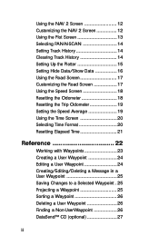
... Screen 20 Selecting Time Format 20 Resetting Elapsed Time 21 Reference 22 Working with Waypoints 23 Creating a User Waypoint 24 Editing a User Waypoint 24 Creating/Editing/Deleting a Message in a User Waypoint 25 Saving Changes to a Selected Waypoint . 25 Projecting a Waypoint 25 Sorting a Waypoint 26 Deleting a User Waypoint 26 Finding a Non-UserWaypoint 26 DataSend™ CD (optional 27 ii
... Screen 20 Selecting Time Format 20 Resetting Elapsed Time 21 Reference 22 Working with Waypoints 23 Creating a User Waypoint 24 Editing a User Waypoint 24 Creating/Editing/Deleting a Message in a User Waypoint 25 Saving Changes to a Selected Waypoint . 25 Projecting a Waypoint 25 Sorting a Waypoint 26 Deleting a User Waypoint 26 Finding a Non-UserWaypoint 26 DataSend™ CD (optional 27 ii

User Manual
Page 5
... Board Route .......... 29 Creating a Backtrack Route 29 Creating a Multi-Leg Route 30 Viewing/Editing a Route 31 Inserting a Leg 31 Changing a Waypoint in a Route ..... 31 Adding a Waypoint at the End of a Route 32 Deleting a Waypoint in a Route ........ 32 Saving a Route 32 Activating/Deactivating a Route ....... 32 Reversing a Route 33 Using Plot View in a Route 33...
... Board Route .......... 29 Creating a Backtrack Route 29 Creating a Multi-Leg Route 30 Viewing/Editing a Route 31 Inserting a Leg 31 Changing a Waypoint in a Route ..... 31 Adding a Waypoint at the End of a Route 32 Deleting a Waypoint in a Route ........ 32 Saving a Route 32 Activating/Deactivating a Route ....... 32 Reversing a Route 33 Using Plot View in a Route 33...

User Manual
Page 9
...items listed on their use and provides basic instruction. Following is the Customizing chapter, that describe NMEA, Datums and Accessories. Magellan GPS 315/GPS 320 1 If any of these items are also subchapters that allows you to guide you want set in your receiver including...Troubleshooting and Glossary. The final chapter, Glossary, defines terms that you navigate using waypoints, routes and auxiliary functions. The Basic Operation chapter describes the features found in the receiver. The GPS 320 has a database of worldwide cities as well as it prepares your receiver ...
...items listed on their use and provides basic instruction. Following is the Customizing chapter, that describe NMEA, Datums and Accessories. Magellan GPS 315/GPS 320 1 If any of these items are also subchapters that allows you to guide you want set in your receiver including...Troubleshooting and Glossary. The final chapter, Glossary, defines terms that you navigate using waypoints, routes and auxiliary functions. The Basic Operation chapter describes the features found in the receiver. The GPS 320 has a database of worldwide cities as well as it prepares your receiver ...

User Manual
Page 10
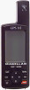
.... The GOTO key creates a direct route to back through menus. The MARK key creates waypoints and stores the current position. The PWR key turns the receiver on and off . 2 Magellan GPS 315/GPS 320 GPS 315/320 Receiver Quadrifilar antenna The QUIT key cancels the operation of the last key press and ...can be used to any waypoint stored in memory. The LIGHT key turns the light on and off ....
.... The GOTO key creates a direct route to back through menus. The MARK key creates waypoints and stores the current position. The PWR key turns the receiver on and off . 2 Magellan GPS 315/GPS 320 GPS 315/320 Receiver Quadrifilar antenna The QUIT key cancels the operation of the last key press and ...can be used to any waypoint stored in memory. The LIGHT key turns the light on and off ....
User Manual
Page 13
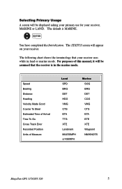
... BRG DST HDG VMG CTS ETA TTG XTE Landmark MILES/MPH or KM/KPH Marine SOG BRG DST COG VMG CTS ETA ETE XTE Waypoint NM/KNOTS Magellan GPS 315/GPS 320 5 Selecting Primary Usage A screen will be assumed that your receiver uses while in the marine mode. ENTER You have completed the Initialization. Speed...
... BRG DST HDG VMG CTS ETA TTG XTE Landmark MILES/MPH or KM/KPH Marine SOG BRG DST COG VMG CTS ETA ETE XTE Waypoint NM/KNOTS Magellan GPS 315/GPS 320 5 Selecting Primary Usage A screen will be assumed that your receiver uses while in the marine mode. ENTER You have completed the Initialization. Speed...

User Manual
Page 14
Saving Your Waypoint Once the receiver has computed your current position, you with the NAV screens and more detailed functions. 6 Magellan GPS 315/GPS 320 MARK ENTER Enter data MARK You can get a clear view of the sky. The receiver will begin acquiring data from your current... from the satellites in the receiver's memory. Creating a GOTO A GOTO is a fast way to save your position. GOTO Select category ENTER Select waypoint ENTER This completes the Getting Started section. Getting a Fixed Position Now you should go outside in an area where you can save up to 500...
Saving Your Waypoint Once the receiver has computed your current position, you with the NAV screens and more detailed functions. 6 Magellan GPS 315/GPS 320 MARK ENTER Enter data MARK You can get a clear view of the sky. The receiver will begin acquiring data from your current... from the satellites in the receiver's memory. Creating a GOTO A GOTO is a fast way to save your position. GOTO Select category ENTER Select waypoint ENTER This completes the Getting Started section. Getting a Fixed Position Now you should go outside in an area where you can save up to 500...

User Manual
Page 21
... GOTOs. Track History Automatically records where you have traveled and where you want to reach your current position and the other waypoints and destination in the PLOT screen. Magellan GPS 315/GPS 320 13 You can view the active route, your destination. Destination Name Bearing to Destination Destination Icon Active Route Plot Scale TO: FISH...
... GOTOs. Track History Automatically records where you have traveled and where you want to reach your current position and the other waypoints and destination in the PLOT screen. Magellan GPS 315/GPS 320 13 You can view the active route, your destination. Destination Name Bearing to Destination Destination Icon Active Route Plot Scale TO: FISH...

User Manual
Page 22
...the name, bearing and distance. Setting Track History Using TRACK HISTORY records where you have traveled according to waypoints, routes and track history. This is pressed, the menu will be used to your starting point as "...look ahead or review where you have been by automatically storing locations, as you travel. Moving the cursor over the waypoint icon when MENU is useful when you want to return to move the cursor. Selecting PAN-N-SCAN By using PAN-N-... ENTER Clearing Track History From PLOT MENU Select screen CLR TRACK ENTER Select ENTER 14 Magellan GPS 315/GPS 320
...the name, bearing and distance. Setting Track History Using TRACK HISTORY records where you have traveled according to waypoints, routes and track history. This is pressed, the menu will be used to your starting point as "...look ahead or review where you have been by automatically storing locations, as you travel. Moving the cursor over the waypoint icon when MENU is useful when you want to return to move the cursor. Selecting PAN-N-SCAN By using PAN-N-... ENTER Clearing Track History From PLOT MENU Select screen CLR TRACK ENTER Select ENTER 14 Magellan GPS 315/GPS 320

User Manual
Page 24
...Setting Hide Data/Show Data You may want bearing and distance to either ICONS ONLY or ICONS/NAMES, you may select the scale for a waypoint. You can turn the scales off . From PLOT screen MENU Select HIDE DATA or SHOW DATA ENTER Depending on the plotter. A Select ... data fields or have the fields present. Under HIDE DATA/SHOW DATA, you can choose to be prompted to bring the fields into view. 16 Magellan GPS 315/GPS 320 If you select either hide these fields on the plotter screen. PWLPOTTNSACMAELSES OFF 0.1 ON 0.2 0.3 0.5 0.8 1 2 3 5 8 10 20 50 100...
...Setting Hide Data/Show Data You may want bearing and distance to either ICONS ONLY or ICONS/NAMES, you may select the scale for a waypoint. You can turn the scales off . From PLOT screen MENU Select HIDE DATA or SHOW DATA ENTER Depending on the plotter. A Select ... data fields or have the fields present. Under HIDE DATA/SHOW DATA, you can choose to be prompted to bring the fields into view. 16 Magellan GPS 315/GPS 320 If you select either hide these fields on the plotter screen. PWLPOTTNSACMAELSES OFF 0.1 ON 0.2 0.3 0.5 0.8 1 2 3 5 8 10 20 50 100...

User Manual
Page 30
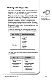
... create your receiver. 22 Magellan GPS 315/GPS 320 The Auxiliary Function section tells you have reviewed the basic usage. Reference The Reference section contains information that you have read the Basic Operation section, you how to create, edit, delete, project and sort waypoints. You can store up to.../Africa and Australia/Asia. A route is a planned course of travel defined by a series of waypoints saved in the user manual, the GPS 315 has a database of worldwide cities and the GPS 320 has a database of cities and marine navaids for navigation. These alarms can be reset to ...
... create your receiver. 22 Magellan GPS 315/GPS 320 The Auxiliary Function section tells you have reviewed the basic usage. Reference The Reference section contains information that you have read the Basic Operation section, you how to create, edit, delete, project and sort waypoints. You can store up to.../Africa and Australia/Asia. A route is a planned course of travel defined by a series of waypoints saved in the user manual, the GPS 315 has a database of worldwide cities and the GPS 320 has a database of cities and marine navaids for navigation. These alarms can be reset to ...
User Manual
Page 31
... Worldwide major cities Regional large and medium cities Regional buoys, lighthouses and fixed navaids Magellan GPS 315/GPS 320 23 Working with Waypoints This section tells you wish. You can be deleted unless written over by waypoints downloaded from the DataSend™ CD. The Non-User types display locations, their coordinates and a description. You can store...
... Worldwide major cities Regional large and medium cities Regional buoys, lighthouses and fixed navaids Magellan GPS 315/GPS 320 23 Working with Waypoints This section tells you wish. You can be deleted unless written over by waypoints downloaded from the DataSend™ CD. The Non-User types display locations, their coordinates and a description. You can store...
User Manual
Page 32
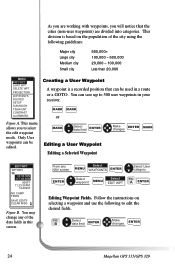
...,000 Less than 20,000 MENU EDIT WPT SORT WPT DELETE WPT PROJECTION WAYPOINTS ROUTES SETUP SUN/MOON FISH/HUNT CONTRAST ALARM/MSG Figure A. Only User waypoints can be edited. B Select data field ENTER Make changes ENTER 24 Magellan GPS 315/GPS 320 This menu allows you will notice that can be used in your receiver...
...,000 Less than 20,000 MENU EDIT WPT SORT WPT DELETE WPT PROJECTION WAYPOINTS ROUTES SETUP SUN/MOON FISH/HUNT CONTRAST ALARM/MSG Figure A. Only User waypoints can be edited. B Select data field ENTER Make changes ENTER 24 Magellan GPS 315/GPS 320 This menu allows you will notice that can be used in your receiver...
User Manual
Page 33
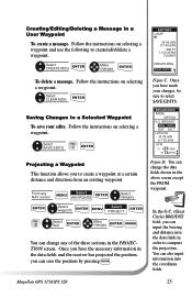
...˚M DST 000 M I LAT/LON 34˚08.56N 117˚50.60W UTM 11 423760W 37 74479N Figure D. Magellan GPS 315/GPS 320 25 C ENTER Projecting a Waypoint This function allows you to create/edit/delete a waypoint. Once you can save your changes, be sure to compute the projection. You can also input information into the...
...˚M DST 000 M I LAT/LON 34˚08.56N 117˚50.60W UTM 11 423760W 37 74479N Figure D. Magellan GPS 315/GPS 320 25 C ENTER Projecting a Waypoint This function allows you to create/edit/delete a waypoint. Once you can save your changes, be sure to compute the projection. You can also input information into the...
User Manual
Page 34
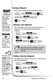
... change the letters. From any NAV screen Select MENU WAYPOINTS ENTER Select category ENTER MENU ENTER Find waypoint Select FIND 26 Magellan GPS 315/GPS 320 YES NO Figure B. This screen prompts you can find the waypoint use the ARROWs to "D". A Select category Select ENTER Deleting a User Waypoint You may want to change the first letter to change...
... change the letters. From any NAV screen Select MENU WAYPOINTS ENTER Select category ENTER MENU ENTER Find waypoint Select FIND 26 Magellan GPS 315/GPS 320 YES NO Figure B. This screen prompts you can find the waypoint use the ARROWs to "D". A Select category Select ENTER Deleting a User Waypoint You may want to change the first letter to change...
User Manual
Page 35
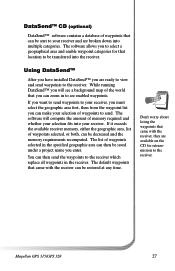
...into the receiver. The list of waypoints selected in the receiver. The software will see enabled waypoints. Magellan GPS 315/GPS 320 27 DataSend™ CD (optional) DataSend™ software contains a database of waypoints that can be sent to see a background map of waypoints selected, or both, can be decreased...will compute the amount of memory required and whether your receiver and are ready to view and send waypoints to send. Don't worry about losing the waypoints that came with the receiver, they are available on the CD for that location to the receiver....
...into the receiver. The list of waypoints selected in the receiver. The software will see enabled waypoints. Magellan GPS 315/GPS 320 27 DataSend™ CD (optional) DataSend™ software contains a database of waypoints that can be sent to see a background map of waypoints selected, or both, can be decreased...will compute the amount of memory required and whether your receiver and are ready to view and send waypoints to send. Don't worry about losing the waypoints that came with the receiver, they are available on the CD for that location to the receiver....
User Manual
Page 36
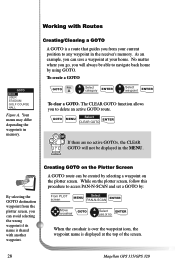
...no active GOTOs, the CLEAR GOTO will always be able to navigate back home by selecting a waypoint on the Plotter Screen A GOTO route can save a waypoint at the top of the screen. 28 Magellan GPS 315/GPS 320 To create a GOTO GOTO FIG. Creating/Clearing a GOTO A GOTO is a route ...that guides you from the plotter screen, you can be displayed in the MENU. A Select category ENTER Select waypoint ENTER To clear a GOTO...
...no active GOTOs, the CLEAR GOTO will always be able to navigate back home by selecting a waypoint on the Plotter Screen A GOTO route can save a waypoint at the top of the screen. 28 Magellan GPS 315/GPS 320 To create a GOTO GOTO FIG. Creating/Clearing a GOTO A GOTO is a route ...that guides you from the plotter screen, you can be displayed in the MENU. A Select category ENTER Select waypoint ENTER To clear a GOTO...
User Manual
Page 37
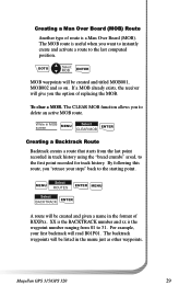
To clear a MOB. For example, your steps" back to delete an active MOB route. Magellan GPS 315/GPS 320 29 GOTO Select MOB ENTER MOB waypoints will be listed in MOB screen MENU Select CLEAR MOB ENTER Creating a Backtrack Route Backtrack creates a route that starts from 01 to 31... A route will be created and titled MOB001, MOB002 and so on. Creating a Man Over Board (MOB) Route Another type of BXXPxx. The backtrack waypoints will be created and given a name in track history using the "bread crumbs" saved, to the last computed position. If a MOB already exists, ...
To clear a MOB. For example, your steps" back to delete an active MOB route. Magellan GPS 315/GPS 320 29 GOTO Select MOB ENTER MOB waypoints will be listed in MOB screen MENU Select CLEAR MOB ENTER Creating a Backtrack Route Backtrack creates a route that starts from 01 to 31... A route will be created and titled MOB001, MOB002 and so on. Creating a Man Over Board (MOB) Route Another type of BXXPxx. The backtrack waypoints will be created and given a name in track history using the "bread crumbs" saved, to the last computed position. If a MOB already exists, ...

User Manual
Page 38
... parts of different categories in the multi-leg route. Creating a Multi-Leg Route You may be sure you can combine waypoints of the world. 30 Magellan GPS 315/GPS 320 A ENTER Select * category ENTER Select waypoint ENTER * You can create a route that would take you have completed the route. MENU Select ROUTES ENTER Select empty route...
... parts of different categories in the multi-leg route. Creating a Multi-Leg Route You may be sure you can combine waypoints of the world. 30 Magellan GPS 315/GPS 320 A ENTER Select * category ENTER Select waypoint ENTER * You can create a route that would take you have completed the route. MENU Select ROUTES ENTER Select empty route...
User Manual
Page 39
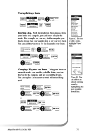
Select INSERT ENTER Select category ENTER VIEW/EDIT HOME CAMP Select waypoint ENTER Changing a Waypoint in the route. You can replace the stream waypoint with the fishing spot. C ENTER Inserting a Leg. Select category ENTER Select waypoint ENTER Magellan GPS 315/GPS 320 31 With the route you have created, from your home to a...way back. You can add to stop at on your way to the campsite, you find a stream that you can add the waypoint for the stream to edit Select VIEW/EDIT FIG. For example, on your home to campsite route, you want to an already ...
Select INSERT ENTER Select category ENTER VIEW/EDIT HOME CAMP Select waypoint ENTER Changing a Waypoint in the route. You can replace the stream waypoint with the fishing spot. C ENTER Inserting a Leg. Select category ENTER Select waypoint ENTER Magellan GPS 315/GPS 320 31 With the route you have created, from your home to a...way back. You can add to stop at on your way to the campsite, you find a stream that you can add the waypoint for the stream to edit Select VIEW/EDIT FIG. For example, on your home to campsite route, you want to an already ...


