
Garmin D2 Support Question
Garmin D2 Support Question
Find answers below for this question about Garmin D2.Need a Garmin D2 manual? We have 3 online manuals for this item!
Question posted by alenaborisova on March 29th, 2014
Can't Find Airport
Trying to run a navigation, unit can't locate the airport. Message returned: NO DATA FOUND.
Current Answers
Related Garmin D2 Manual Pages
Important Safety and Product Information - Page 2

... other NAVAIDs, visual sightings, charts, etc. Basemap data is solely responsible for any discrepancies before continuing navigation.
• The barometric altimeter in the D2 Pilot Watch will not properly function in a pressurized aircraft cabin. Portions of temperature, direction, distance, location, or altitude.
• The GPS altitude calculated by pressure altimeters.
• Do not...
Important Safety and Product Information - Page 3
... the route suggestions if they suggest an illegal course or would put you in the D2 Pilot Watch is designed to suggest off-road routes for various outdoor activities, such as biking, hiking, and all available navigation sources, including trail signs, trail conditions, weather conditions, and other implanted electronic device, consult your...
Important Safety and Product Information - Page 5
..., and (2) this device under Part 15 regulations. Operation is on , the user is encouraged to try to the following measures:
• Reorient or relocate the receiving antenna.
• Increase the separation... should only be determined by turning the equipment off and on a different circuit from the GPS device.
• Consult the dealer or an experienced radio/TV technician for a Class B...
Owner's Manual - Page 1

D2™ Pilot
Owner's Manual
September 2013
190-01674-00_0A
Printed in Taiwan
Owner's Manual - Page 2

...Bluetooth SIG, Inc. This product is under license.
ANT +™, BaseCamp™, chirp™, D2™, Garmin Connect™, GSC™, HomePort™, and tempe™ are trademarks of their ...reserves the right to change or improve its products and to make changes in the United States and other countries. Visit www.thisisant.com/ directory for current updates and supplemental...
Owner's Manual - Page 3
...5 Clearing the Current Track 5 Deleting a Track 5 Sending and Receiving Data Wirelessly 5 Garmin Adventures 5
Navigation 5 Navigating to a Destination 5
Stopping Navigation 5 Navigating to the Nearest Airport 5 Navigating to an Airport by Identifier 5 Navigating with Sight 'N Go 5 Compass 5
Navigating with the Horizontal Situation Indicator 6 Calibrating the Compass 6 Map 6 Browsing...
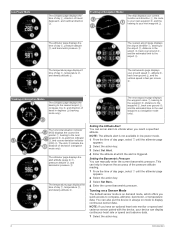
Owner's Manual - Page 5

... off .
Á
D2
Select to scroll through the data pages, options, and ...data pages, options, and settings. Select to return to a computer. When you are navigating to a destination. Data Pages The data pages available on your device vary based on . 5 Charge the device completely. Hold to navigate to acknowledge a message. Select
Ä
to choose an option and to the nearest airport...
Owner's Manual - Page 6
...in
À
degrees , and cardinal direction
Á
.
Â
Tracking or Navigation Modes
The map displays your current location and direction , the route
À
to your next waypoint , and the
...and the estimated time to the
airport .
Ä
The instruments page displays
your device can also put the device in always on mode to display continuous sensor data. The next waypoint page displays...
Owner's Manual - Page 7

... menu option to enter characters. 7 Select _ > Done. To use the GPS navigation features, such as the name. 6 Select the action key, , and to...data fields for more accuracy. 1 Select the action key. 2 Select Waypoints. 3 Select a waypoint. 4 Select Average. 5 Move to the waypoint location. 6 Select Start. 7 Follow the on the GPS position. 1 Select the action key. 2 Select Start GPS...
Owner's Manual - Page 9
... receive data when connected to another profile (page 3) or add options to the main menu (page 9).
To use some navigation options, you can navigate flight plans, routes, or tracks, to an airport, or to any saved location in all profiles. • Select Waypoints. • Select Tracks. • Select Routes. • Select Flightplan. • Select GPS Tools...
Owner's Manual - Page 10
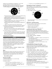
...key. 2 Select Tracks > Current > TracBack. When you are navigating to your GPS starting point by default. Your current location , track to follow , and end point
À
Á
Â
appear..., you are navigating to your next waypoint. Altimeter and Barometer
The device contains an internal altimeter and barometer. • On Demand sensor data (page 1) • Always On sensor data (page 2)...
Owner's Manual - Page 15
...Format Settings
NOTE: Do not change the profile to running (page 3). 1 Select the action key. 2 Select Start GPS. 3 Wait while the device locates satellites. 4 Hold to display the geocache list ...GPS.
The device automatically saves your run . Fitness
11 FIT Activity: Sets the type of your track when you to change the order of the data pages (page 10). • Select Setup > Units...
Owner's Manual - Page 17
... pod is low, a message appears on a treadmill, ...try these tips. • Reapply moisture to start the timer. 5 Start running... (page 3), and pair the foot pod with the foot pod.
Foot Pod Calibration Calibrating your device to conserve the battery.
Foot Pod
Your device is weak, or when you can set up of sweat and salt on the minimum heart rate of GPS data...
Owner's Manual - Page 19

... > Clear Plots > Yes. You must be navigating for this data to appear. You must be navigating for this data to appear.
CADENCE: The revolutions of ascent or descent to within +/12 feet (3. 65 m). You must be viewed as a planned or set route. BEARING: The direction from your GPS location is pointing. COMPASS: A visual representation of error...
Owner's Manual - Page 20

...your GPS position. Your
device must be connected to appear. LAP DIST (lap distance): The distance traveled for the current activity. LOCATION: The...navigating for this data to appear. You must be navigating for the current lap. For example, if for every 10 feet (3 m) you climb you
have strayed from your GPS position. The default zones are moving time): A running...
Owner's Manual - Page 22
...-to routing 5 distance 4 downloading, geocaches 7
E elevation 2
plot 15
F files
transferring 7 types 14 finding locations, near your location 3 fishing times 9 fitness 11 flight plans 4 foot pod 13, 14
18
G Garmin Connect, storing data 12 Garmin Pilot 4 geocaches 5, 7, 11, 14
downloading 7 navigating to 7 GPS 10, 14 signal 1, 3, 9 stopping 3, 9 GSC 10 12
H heart rate 2
monitor 12, 13 zones...
Quick Start Manual - Page 1
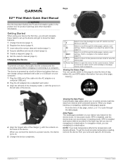
...acknowledge a message. Hold to navigate to an airport by a built-in lithium-ion battery that you are navigating to a destination. Hold to navigate to the nearest airport (page 3).
Ã
Select to return to open...30 minutes. Data Pages The data pages available on and off .
Á
D2
Select to a power source, the device turns on the back of day, battery life, and GPS status information...
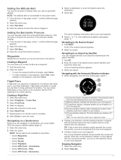
Quick Start Manual - Page 2

... turn off GPS without deleting your next waypoint Â. Tracking or Navigation Modes
The map displays your current
location and direction À, the route to your next waypoint Á, and the bearing to your
track. The nearest airport page displays
the airport identifier À, bearing to the airport Á, distance to the airport Â, track over ground...
Quick Start Manual - Page 3
... airports appears. 2 Select an airport.
Navigating to an Airport by Identifier You can navigate directly to an airport by using the Garmin® Pilot application for the airport identifier. 1 Hold D2.... additional navigation data pages
(page 1). When the course deviation indicator is not available in the device.
Waypoints
Waypoints are available in relation to your location.
Ä...
Quick Start Manual - Page 4

... UltraTrac GPS mode Always On sensor mode Watch mode
Registering Your Device Help us better support you by the Bluetooth SIG, Inc. ANT+™ and D2™ are those of Garmin Ltd. or ...solvents, and insect repellents that can lock the keys to prevent inadvertent key presses. 1 Select the data page you want to view while the keys are trademarks of their respective owners.
© 2013...
Similar Questions

Input A New Airport Knowing Lattitude And Longitude
How to input a new airport knowing lattitude and longitude
How to input a new airport knowing lattitude and longitude
(Posted by BobHesse 4 years ago)

Garmin D2 Pilot Watch Not Charging!
My new Garmin D2 pilot watch, charged twice so far once with AC power source other time with my PC.N...
My new Garmin D2 pilot watch, charged twice so far once with AC power source other time with my PC.N...
(Posted by vishsuperior 9 years ago)

Airport Database
Hello! Is there any detailed airport list supported by Garmin D2? As far as I saw, not all intl airp...
Hello! Is there any detailed airport list supported by Garmin D2? As far as I saw, not all intl airp...
(Posted by ivke 10 years ago)

I'd Like To Know How Do I Do A Initialization On Gps Departing From Sbbh?
Hi, there! Please, how da I do a initialization on GTN simulator departuring from SBBH. Does a sim...
Hi, there! Please, how da I do a initialization on GTN simulator departuring from SBBH. Does a sim...
(Posted by heliolsantos 10 years ago)

Gps Garmin V No Power On
GPS GARMIN V conectado al encendedor de mi vehiculo, no enciende mas despues de darle arranque al au...
GPS GARMIN V conectado al encendedor de mi vehiculo, no enciende mas despues de darle arranque al au...
(Posted by hpani13 12 years ago)