User Manual
Page 178
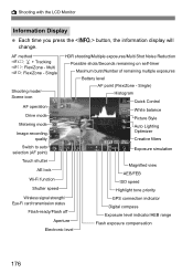
... speed Magnified view AEB/FEB ISO speed Highlight tone priority Wireless signal strength/ Eye-Fi card transmission status Flash-ready/Flash off Aperture Electronic level GPS connection indicator Digital compass Exposure level indicator/AEB range Flash exposure compensation 176 A Shooting with the LCD Monitor Information Display Each time you press...
... speed Magnified view AEB/FEB ISO speed Highlight tone priority Wireless signal strength/ Eye-Fi card transmission status Flash-ready/Flash off Aperture Electronic level GPS connection indicator Digital compass Exposure level indicator/AEB range Flash exposure compensation 176 A Shooting with the LCD Monitor Information Display Each time you press...
User Manual
Page 205
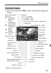
...: Manual Movie Servo AF Headphone volume AE lock Movie recording format Shutter speed Wi-Fi function Wireless signal strength/Eye-Fi card transmission status Aperture GPS connection indicator Magnify/Digital zoom Creative filters Digital compass ISO speed Highlight tone priority Exposure level indicator Exposure compensation Attenuator Level meter Wind filter: Disable...
...: Manual Movie Servo AF Headphone volume AE lock Movie recording format Shutter speed Wi-Fi function Wireless signal strength/Eye-Fi card transmission status Aperture GPS connection indicator Magnify/Digital zoom Creative filters Digital compass ISO speed Highlight tone priority Exposure level indicator Exposure compensation Attenuator Level meter Wind filter: Disable...
User Manual
Page 222
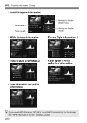
B: Shooting Information Display • Lens/Histogram information Lens name Focal length • White balance information Histogram display (Brightness) Histogram display (RGB) • Picture Style information 1 • Picture Style information 2 • Color space / Noise reduction information • Lens aberration correction information If you used GPS Receiver GP-E2 to record GPS information for the image, the "GPS information" screen will also appear. 220
B: Shooting Information Display • Lens/Histogram information Lens name Focal length • White balance information Histogram display (Brightness) Histogram display (RGB) • Picture Style information 1 • Picture Style information 2 • Color space / Noise reduction information • Lens aberration correction information If you used GPS Receiver GP-E2 to record GPS information for the image, the "GPS information" screen will also appear. 220
User Manual
Page 262
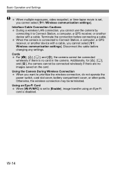
... in the camera. W-14 Interface Cable Connection Cautions During a wireless LAN connection, you cannot use the camera by connecting it to Connect Station, a computer, a GPS receiver, or another device with a cable. Basic Operation and Settings When multiple exposures, video snapshot, or time-lapse movie is connected to Connect Station...
... in the camera. W-14 Interface Cable Connection Cautions During a wireless LAN connection, you cannot use the camera by connecting it to Connect Station, a computer, a GPS receiver, or another device with a cable. Basic Operation and Settings When multiple exposures, video snapshot, or time-lapse movie is connected to Connect Station...

User Manual
Page 289
...the camera receiving the images. Connecting to a Camera 5 Select the images to send. Select images on the camera's playback screen even if GPS information is appended to which a connection was established. While connected, the camera's auto power off does not function. The settings for connecting to...registered with the nickname of the camera to the received image. Shooting locations can be viewed on a virtual map, using Map Utility (EOS software). The connection settings are now complete. W-41 For operations after setting up a connection, see page W-42.
...the camera receiving the images. Connecting to a Camera 5 Select the images to send. Select images on the camera's playback screen even if GPS information is appended to which a connection was established. While connected, the camera's auto power off does not function. The settings for connecting to...registered with the nickname of the camera to the received image. Shooting locations can be viewed on a virtual map, using Map Utility (EOS software). The connection settings are now complete. W-41 For operations after setting up a connection, see page W-42.
