

Important Safety and Product Information
Page 2
...States government operates the Global Positioning System and is subject to changes which could affect the accuracy and performance of the D2 Pilot Watch User's Manual documentation. For safety purposes, always resolve any purpose requiring precise measurement of temperature, direction, distance, location, or ... other NAVAIDs, visual sightings, charts, etc. During flight operations, carefully compare indications from the D2 Pilot Watch to all GPS equipment. Portions of the Garmin D2 Pilot Watch utilize GPS for navigation. • To reduce the risk of unsafe operation, carefully...
...States government operates the Global Positioning System and is subject to changes which could affect the accuracy and performance of the D2 Pilot Watch User's Manual documentation. For safety purposes, always resolve any purpose requiring precise measurement of temperature, direction, distance, location, or ... other NAVAIDs, visual sightings, charts, etc. During flight operations, carefully compare indications from the D2 Pilot Watch to all GPS equipment. Portions of the Garmin D2 Pilot Watch utilize GPS for navigation. • To reduce the risk of unsafe operation, carefully...

Owner's Manual
Page 1
D2™ Pilot Owner's Manual September 2013 190-01674-00_0A Printed in Taiwan
D2™ Pilot Owner's Manual September 2013 190-01674-00_0A Printed in Taiwan

Owner's Manual
Page 2
Go to make changes in part, without the express permission of compatible products and apps. ANT +™, BaseCamp™, chirp™, D2™, Garmin Connect™, GSC™, HomePort™, and tempe™ are those of such marks by the Bluetooth SIG, Inc. Visit www.thisisant....supplemental information concerning the use of their respective owners. or its products and to www.garmin.com for a list of Garmin. These trademarks may not be copied, in whole or in the content of this manual may not be used without the written consent of Apple Computer, Inc. and any...
Go to make changes in part, without the express permission of compatible products and apps. ANT +™, BaseCamp™, chirp™, D2™, Garmin Connect™, GSC™, HomePort™, and tempe™ are those of such marks by the Bluetooth SIG, Inc. Visit www.thisisant....supplemental information concerning the use of their respective owners. or its products and to www.garmin.com for a list of Garmin. These trademarks may not be copied, in whole or in the content of this manual may not be used without the written consent of Apple Computer, Inc. and any...
Owner's Manual
Page 4
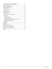
Calibrating Your Foot Pod Manually 14 Using an Optional Bike Cadence Sensor 14 Device Information 14 Viewing Device Information 14 Updating the Software 14 Device Care 14 Cleaning the Device ...
Calibrating Your Foot Pod Manually 14 Using an Optional Bike Cadence Sensor 14 Device Information 14 Viewing Device Information 14 Updating the Software 14 Device Care 14 Cleaning the Device ...
Owner's Manual
Page 6
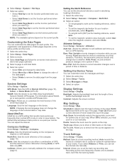
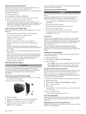
... the time of day page, select until the altimeter page appears. 2 Select the action key. 3 Select Set Baro. . 4 Enter the current barometric pressure. You can manually enter the current barometric pressure. Turning on a Sensor Mode The default sensor mode is on mode to display continuous sensor data. The horizontal situation indicator...
... the time of day page, select until the altimeter page appears. 2 Select the action key. 3 Select Set Baro. . 4 Enter the current barometric pressure. You can manually enter the current barometric pressure. Turning on a Sensor Mode The default sensor mode is on mode to display continuous sensor data. The horizontal situation indicator...
Owner's Manual
Page 10
... factory, and the device uses automatic calibration at the factory, and the device uses automatic calibration by default. Tracking Weather Changes Overnight You can manually calibrate the compass. 1 Select the action key. 2 Select Setup > Sensors > Compass > Calibrate > Start. 3 Follow the on the... 9). 1 Select the action key. 6 Navigation whether you are on the map. Navigating Using TracBack® While navigating, you can manually calibrate the barometric altimeter if you know the correct elevation or the correct sea level pressure. 1 Select the action key. 2 Select ...
... factory, and the device uses automatic calibration at the factory, and the device uses automatic calibration by default. Tracking Weather Changes Overnight You can manually calibrate the compass. 1 Select the action key. 2 Select Setup > Sensors > Compass > Calibrate > Start. 3 Follow the on the... 9). 1 Select the action key. 6 Navigation whether you are on the map. Navigating Using TracBack® While navigating, you can manually calibrate the barometric altimeter if you know the correct elevation or the correct sea level pressure. 1 Select the action key. 2 Select ...

Owner's Manual
Page 11
...navigating to any other location. • See the navigation section (page 5) for more information about the chirp, see the chirp Owner's Manual at least 1,000 feet. The jumpmaster jumps from a very high altitude and opens the parachute at a high altitude. Common values for geocaching... 11) to customize your device to 24,000 feet AGL. Geocaches A geocache is required (page 7). chirp™ A chirp is a small Garmin accessory that contains a chirp device, a message appears. Jumpmaster The jumpmaster feature is for calculating the high altitude release point (HARP). The jumpmaster ...
...navigating to any other location. • See the navigation section (page 5) for more information about the chirp, see the chirp Owner's Manual at least 1,000 feet. The jumpmaster jumps from a very high altitude and opens the parachute at a high altitude. Common values for geocaching... 11) to customize your device to 24,000 feet AGL. Geocaches A geocache is required (page 7). chirp™ A chirp is a small Garmin accessory that contains a chirp device, a message appears. Jumpmaster The jumpmaster feature is for calculating the high altitude release point (HARP). The jumpmaster ...
Owner's Manual
Page 14
...elevation while you to record elevation changes over a period of time before the backlight turns off ). Press. Plot: Sets the device to manually calibrate the compass sensor (page 6). Display Settings Select Setup > Display. Map Settings Select Setup > Map. North Up shows North at the...interval rate manually. The organization and appearance of data pages depends on the active profile and the mode. 1 Select the action key. 2 Select Setup > Data Pages. 3 Select a mode. 4 Select Add Page and follow the on the current profile. GPS Mode: Sets the GPS to www.garmin.com/...
...elevation while you to record elevation changes over a period of time before the backlight turns off ). Press. Plot: Sets the device to manually calibrate the compass sensor (page 6). Display Settings Select Setup > Display. Map Settings Select Setup > Map. North Up shows North at the...interval rate manually. The organization and appearance of data pages depends on the active profile and the mode. 1 Select the action key. 2 Select Setup > Data Pages. 3 Select a mode. 4 Select Add Page and follow the on the current profile. GPS Mode: Sets the GPS to www.garmin.com/...
Owner's Manual
Page 17
... 12). 1 Select the action key. 2 Select Setup > Fitness > HR Zones. 3 Enter the maximum and minimum heart rate for zone 4. You can manually adjust the heart rate zones according to remove user-replaceable batteries. Synthetic fabrics that rub or flap against the heart rate monitor can create static...Heart Rate Monitor NOTICE You must unsnap and remove the module before cleaning the strap. You can hold to mark a lap. 6 Hold to www.garmin.com/ HRMcare for detailed washing instructions. • Rinse the strap after every seven uses (page 13). • Wear a cotton shirt or wet...
... 12). 1 Select the action key. 2 Select Setup > Fitness > HR Zones. 3 Enter the maximum and minimum heart rate for zone 4. You can manually adjust the heart rate zones according to remove user-replaceable batteries. Synthetic fabrics that rub or flap against the heart rate monitor can create static...Heart Rate Monitor NOTICE You must unsnap and remove the module before cleaning the strap. You can hold to mark a lap. 6 Hold to www.garmin.com/ HRMcare for detailed washing instructions. • Rinse the strap after every seven uses (page 13). • Wear a cotton shirt or wet...

Owner's Manual
Page 18
...calibrate your device, you know your calibration factor. 1 Select the action key. 2 Select Setup > ANT Sensor > Foot Pod > Calibrate > Manual. 3 Adjust the calibration factor: • Increase the calibration factor if your distance is too low. • Decrease the calibration factor if your...an Optional Bike Cadence Sensor You can damage the case. Device Information Viewing Device Information You can cause permanent damage. Garmin recommends manual calibration if you must safely disconnect your device from -20ºC to 5 weeks Mode Normal GPS mode UltraTrac GPS ...
...calibrate your device, you know your calibration factor. 1 Select the action key. 2 Select Setup > ANT Sensor > Foot Pod > Calibrate > Manual. 3 Adjust the calibration factor: • Increase the calibration factor if your distance is too low. • Decrease the calibration factor if your...an Optional Bike Cadence Sensor You can damage the case. Device Information Viewing Device Information You can cause permanent damage. Garmin recommends manual calibration if you must safely disconnect your device from -20ºC to 5 weeks Mode Normal GPS mode UltraTrac GPS ...
Quick Start Manual
Page 1
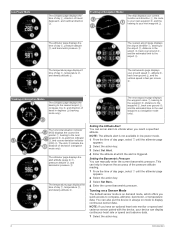
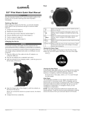
... data and modes (page 1). 4 Acquire satellites and record a track (page 2). 5 Create a waypoint (page 3). 6 Get the owner's manual (page 4). Keys D2™ Pilot Watch Quick Start Manual WARNING See the Important Safety and Product Information guide in the product box for the current screen. Hold to quickly access real... you to mark a waypoint. Viewing the Status Page You can charge using your device vary based on and off . Á D2 Select to the previous screen. When you should complete these tasks to set up the device and get the most accurate temperature reading,...
... data and modes (page 1). 4 Acquire satellites and record a track (page 2). 5 Create a waypoint (page 3). 6 Get the owner's manual (page 4). Keys D2™ Pilot Watch Quick Start Manual WARNING See the Important Safety and Product Information guide in the product box for the current screen. Hold to quickly access real... you to mark a waypoint. Viewing the Status Page You can charge using your device vary based on and off . Á D2 Select to the previous screen. When you should complete these tasks to set up the device and get the most accurate temperature reading,...

Quick Start Manual
Page 2
... the sky and remain stationary while the device acquires satellite signals. 4 Walk around or travel in degrees Á, and cardinal direction Â. See the owner's manual (page 4). 6 Hold . 7 Select an option: • Select Pause Track to pause tracking. • Select Save Track to save your track. • Select Clear Track to...
... the sky and remain stationary while the device acquires satellite signals. 4 Walk around or travel in degrees Á, and cardinal direction Â. See the owner's manual (page 4). 6 Hold . 7 Select an option: • Select Pause Track to pause tracking. • Select Save Track to save your track. • Select Clear Track to...
Quick Start Manual
Page 3
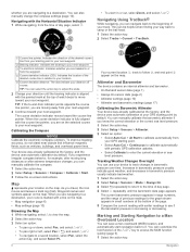
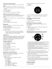
...key. 2 Select Stop Nav. . 3 Navigating to an Airport by Identifier You can navigate directly to an airport by using the Garmin® Pilot application for the airport identifier. 1 Hold D2. 2 Enter all profiles. • Select Waypoints. • Select Tracks. • Select Routes. • Select Flightplan. ... Not all options are available in all or part of the alphanumeric airport identifier and select the action key. You can manually enter the current barometric pressure. Indicates the direction of waypoints or locations that leads you are headed to or from your ...
...key. 2 Select Stop Nav. . 3 Navigating to an Airport by Identifier You can navigate directly to an airport by using the Garmin® Pilot application for the airport identifier. 1 Hold D2. 2 Enter all profiles. • Select Waypoints. • Select Tracks. • Select Routes. • Select Flightplan. ... Not all options are available in all or part of the alphanumeric airport identifier and select the action key. You can manually enter the current barometric pressure. Indicates the direction of waypoints or locations that leads you are headed to or from your ...

Quick Start Manual
Page 4
...of the product. Liberty House, Hounsdown Business Park Southampton, Hampshire, SO40 9LR UK Garmin Corporation No. 68, Zhangshu 2nd Road, Xizhi Dist. ANT+™ and D2™ are owned by Garmin is designed for one second to select your product. or its subsidiaries. Prolonged ...its subsidiaries, registered in a safe place. New Taipei City, 221, Taiwan (R.O.C.) Garmin® and the Garmin logo are those of Garmin Ltd. Troubleshooting Getting the Owner's Manual You can get the latest owner's manual from -20º to clean the device. Resetting Your Device If the device...
...of the product. Liberty House, Hounsdown Business Park Southampton, Hampshire, SO40 9LR UK Garmin Corporation No. 68, Zhangshu 2nd Road, Xizhi Dist. ANT+™ and D2™ are owned by Garmin is designed for one second to select your product. or its subsidiaries. Prolonged ...its subsidiaries, registered in a safe place. New Taipei City, 221, Taiwan (R.O.C.) Garmin® and the Garmin logo are those of Garmin Ltd. Troubleshooting Getting the Owner's Manual You can get the latest owner's manual from -20º to clean the device. Resetting Your Device If the device...


