
GPSMAP 2106/2110 Owner's Manual
Page 4
... Registration v Contact Garmin...v Software License Agreement v Warning ...iv Caution ...iv Getting Started 1 Unit Overview 1 Using the GPSMAP 2106/2110 Keypad 2 Using Soft Keys...3 Using Data Entry/Shortcut Keys 3 Status Bar...3 Turning on the GPSMAP 2106/2110 4 Adjusting the Backlight 4 Initializing the GPS Receiver 5 Receiver Status and Accuracy 6 GPS Setup...6 Using Simulator Mode 7 Basic Operation 8 Using the GPSMAP 2106/2110 8 Selecting Options...
... Registration v Contact Garmin...v Software License Agreement v Warning ...iv Caution ...iv Getting Started 1 Unit Overview 1 Using the GPSMAP 2106/2110 Keypad 2 Using Soft Keys...3 Using Data Entry/Shortcut Keys 3 Status Bar...3 Turning on the GPSMAP 2106/2110 4 Adjusting the Backlight 4 Initializing the GPS Receiver 5 Receiver Status and Accuracy 6 GPS Setup...6 Using Simulator Mode 7 Basic Operation 8 Using the GPSMAP 2106/2110 8 Selecting Options...

GPSMAP 2106/2110 Owner's Manual
Page 5
...Highway Page 41 Changing the Highway Perspective Range 41 Highway Page Options 41 Showing or Hiding Cartography 42 Main Menu 43 GPS Tab...43 Tide Tab ...44 Tide Sub Tab ...44 Current Sub Tab ...46 Celestial Tab 47 Trip Tab...48 ...Tab ...50 Tracks Tab...50 DSC (Digital Selective Calling) Tab 52 Understanding DSC Distress Calls 52 Understanding Position Reports 52 Review DSC Waypoint 53 Setting Up DSC ...54 Using the NAV Key 54 Card Tab ...54 Messages Tab 55 Viewing Detailed ...Tab ...78 General Sub Tab ...79 Graph Sub Tab ...80 Water Temp Sub Tab 81 GPSMAP 2106/2110 Owner's Manual iii
...Highway Page 41 Changing the Highway Perspective Range 41 Highway Page Options 41 Showing or Hiding Cartography 42 Main Menu 43 GPS Tab...43 Tide Tab ...44 Tide Sub Tab ...44 Current Sub Tab ...46 Celestial Tab 47 Trip Tab...48 ...Tab ...50 Tracks Tab...50 DSC (Digital Selective Calling) Tab 52 Understanding DSC Distress Calls 52 Understanding Position Reports 52 Review DSC Waypoint 53 Setting Up DSC ...54 Using the NAV Key 54 Card Tab ...54 Messages Tab 55 Viewing Detailed ...Tab ...78 General Sub Tab ...79 Graph Sub Tab ...80 Water Temp Sub Tab 81 GPSMAP 2106/2110 Owner's Manual iii
GPSMAP 2106/2110 Owner's Manual
Page 60
... tab to control and set off, and the call is specific to the receiver. When the GPSMAP 2106/2110 is used by mariners for a distress call within range. The alarm sounds only for two major operations-distress...Review. Distress calls are received, the oldest is removed when a new call at the top. Log Sub Tab When DSC calls are received, they are automatically stored in the "Appendix." Understanding Position Reports The position report operates similarly to transmit and receive location information. See the GPSMAP 2106/2110 & GPS 17 Installation Instructions for the Garmin...
... tab to control and set off, and the call is specific to the receiver. When the GPSMAP 2106/2110 is used by mariners for a distress call within range. The alarm sounds only for two major operations-distress...Review. Distress calls are received, the oldest is removed when a new call at the top. Log Sub Tab When DSC calls are received, they are automatically stored in the "Appendix." Understanding Position Reports The position report operates similarly to transmit and receive location information. See the GPSMAP 2106/2110 & GPS 17 Installation Instructions for the Garmin...
GPSMAP 2106/2110 Owner's Manual
Page 61
Review DSC Waypoint The Review DSC Waypoint Page operates similarly to the log, the new name appears under the corresponding MMSI number. To add a new directory item: 1. After creating a New Directory Item entry, the name created is only available in the GPS. If you can save the entry... a name is from this page you return to the Distress Page and Position Report Page. The Directory Item Review window allows you want to 100 contacts. Review DSC Waypoint GPSMAP 2106/2110 Owner's Manual 4. Highlight the MMSI, Name, or Comment field, and press ENTER. 3. Another way...
Review DSC Waypoint The Review DSC Waypoint Page operates similarly to the log, the new name appears under the corresponding MMSI number. To add a new directory item: 1. After creating a New Directory Item entry, the name created is only available in the GPS. If you can save the entry... a name is from this page you return to the Distress Page and Position Report Page. The Directory Item Review window allows you want to 100 contacts. Review DSC Waypoint GPSMAP 2106/2110 Owner's Manual 4. Highlight the MMSI, Name, or Comment field, and press ENTER. 3. Another way...

GPSMAP 2106/2110 Owner's Manual
Page 94
...GPS coordinates to the call transmits on the VHF radio. When the unit is approximately 30 meters. These procedures are currently under review by the United States Coast Guard. For more information regarding MMSIs visit: http://www.navcen.uscg.gov/marcomms/gmdss/mmsi.htm. Any DSC-equipped mariner... radio spectrum management of a LORAN receiver. These values vary for the desired destination. Failure to commercial and recreational vessels. Because GPSMAP 2106/2110 Owner's Manual How Can Garmin Help You with DSC support. To receive Distress Calls or Position Reports, you...
...GPS coordinates to the call transmits on the VHF radio. When the unit is approximately 30 meters. These procedures are currently under review by the United States Coast Guard. For more information regarding MMSIs visit: http://www.navcen.uscg.gov/marcomms/gmdss/mmsi.htm. Any DSC-equipped mariner... radio spectrum management of a LORAN receiver. These values vary for the desired destination. Failure to commercial and recreational vessels. Because GPSMAP 2106/2110 Owner's Manual How Can Garmin Help You with DSC support. To receive Distress Calls or Position Reports, you...

GPSMAP 2106/2110 Owner's Manual
Page 103
... 4 basic operation 8 battery alarm 57 Bearing pointer 40 beeper 59 BlueChart 11 BlueChart g2 36, 92 GPSMAP 2106/2110 Owner's Manual bottom of the water 73 btm (bottom) lock 77 C Card tab 54 cartography 36 ...85 directory 53 distress call 52, 86 log 52 position report 52, 86 setup 54 DSC Item Review 53 DSC tab 52 dual beam 72 dual frequency 72 E edit routes 26 waypoints 15 elevation units ... function adjustments 33 function windows 33 G gain 76 gain setting 73 Go To Point 20 GPS accuracy alarm 57 GPS receiver initializing 5 GPS status icon 5 GPS tab 5, 43 GSD 20 i, 58, 72 GSD 21 58, 72 GSD 22 i, ...
... 4 basic operation 8 battery alarm 57 Bearing pointer 40 beeper 59 BlueChart 11 BlueChart g2 36, 92 GPSMAP 2106/2110 Owner's Manual bottom of the water 73 btm (bottom) lock 77 C Card tab 54 cartography 36 ...85 directory 53 distress call 52, 86 log 52 position report 52, 86 setup 54 DSC Item Review 53 DSC tab 52 dual beam 72 dual frequency 72 E edit routes 26 waypoints 15 elevation units ... function adjustments 33 function windows 33 G gain 76 gain setting 73 Go To Point 20 GPS accuracy alarm 57 GPS receiver initializing 5 GPS status icon 5 GPS tab 5, 43 GSD 20 i, 58, 72 GSD 21 58, 72 GSD 22 i, ...

GPSMAP 2106/2110 Owner's Manual
Page 104
...simulator mode 7 setting up 87 using 86 M magnetic north 61 Main Menu 43-71 Card tab 54 Celestial tab 47 GPS tab 43 Highway tab 71 Messages tab 55 Network tab 64 overview 43 Pages tab 64 Points tab 49 Routes tab ...19 clearing 19 proximity waypoint list 18 Q QUICK NAV route 25 QUIT key 2 R re-evaluate route 25 receiver status 6 replace from card 55 review waypoint page 15 ROCKER key 2 routes 23-29 copying 25 creating 23 deleting 26 editing 26 navigating 24 ... version 59 soft keys 3, 9 soft structure 73 Sonar understanding 72-81 sonar alarms 58 Sonar Page 74-77 GPSMAP 2106/2110 Owner's Manual
...simulator mode 7 setting up 87 using 86 M magnetic north 61 Main Menu 43-71 Card tab 54 Celestial tab 47 GPS tab 43 Highway tab 71 Messages tab 55 Network tab 64 overview 43 Pages tab 64 Points tab 49 Routes tab ...19 clearing 19 proximity waypoint list 18 Q QUICK NAV route 25 QUIT key 2 R re-evaluate route 25 receiver status 6 replace from card 55 review waypoint page 15 ROCKER key 2 routes 23-29 copying 25 creating 23 deleting 26 editing 26 navigating 24 ... version 59 soft keys 3, 9 soft structure 73 Sonar understanding 72-81 sonar alarms 58 Sonar Page 74-77 GPSMAP 2106/2110 Owner's Manual

GPSMAP 2106/2110 Owner's Manual
Page 105
adjustment menu 76 configuring 75 Sonar tab 78-81 sound waves 72 source, GPS 6 specifications 82 speed filter 58 speed units 60 status bar 3,... 44 time duration 81 time format 61 time zone 61 TracBack 20, 22 Tips 22 GPSMAP 2106/2110 Owner's Manual Tracks deleting 51 reviewing 22 saving 21 Tracks tab 50 track color 51 track logs 21, 50 track up ...temperature alarm 58 waypoints 13-25 creating 13 deleting 18 editing 15 marking 13, 78 moving 16 proximity 18 reviewing 15 underwater 78 using 13 waypoint list 17 waypoint name changing 16 waypoint symbol changing 16 weakest returns 73...
adjustment menu 76 configuring 75 Sonar tab 78-81 sound waves 72 source, GPS 6 specifications 82 speed filter 58 speed units 60 status bar 3,... 44 time duration 81 time format 61 time zone 61 TracBack 20, 22 Tips 22 GPSMAP 2106/2110 Owner's Manual Tracks deleting 51 reviewing 22 saving 21 Tracks tab 50 track color 51 track logs 21, 50 track up ...temperature alarm 58 waypoints 13-25 creating 13 deleting 18 editing 15 marking 13, 78 moving 16 proximity 18 reviewing 15 underwater 78 using 13 waypoint list 17 waypoint name changing 16 waypoint symbol changing 16 weakest returns 73...

Owner's Manual
Page 4
... Registration v Contact Garmin...v Software License Agreement v Warning...vi Caution...vi Getting Started 1 Unit Overview 1 Using the GPSMAP 2106/2110 Keypad 2 Using Soft Keys...3 Using Data Entry/Shortcut Keys 3 Status Bar...3 Turning on the GPSMAP 2106/2110 4 Adjusting the Backlight 4 Initializing the GPS Receiver 5 Receiver Status and Accuracy 6 GPS Setup...6 Using Simulator Mode 7 Basic Operation 8 Using the GPSMAP 2106/2110 8 Selecting Options...
... Registration v Contact Garmin...v Software License Agreement v Warning...vi Caution...vi Getting Started 1 Unit Overview 1 Using the GPSMAP 2106/2110 Keypad 2 Using Soft Keys...3 Using Data Entry/Shortcut Keys 3 Status Bar...3 Turning on the GPSMAP 2106/2110 4 Adjusting the Backlight 4 Initializing the GPS Receiver 5 Receiver Status and Accuracy 6 GPS Setup...6 Using Simulator Mode 7 Basic Operation 8 Using the GPSMAP 2106/2110 8 Selecting Options...
Owner's Manual
Page 5
... Page 41 Changing the Highway Perspective Range 41 Highway Page Options 41 Showing or Hiding Cartography 42 Main Menu 43 GPS Tab...43 Tide Tab...44 Tide Sub Tab...44 Current Sub Tab...46 Celestial Tab 47 Trip Tab...48 Points...Tab...50 Tracks Tab...50 DSC (Digital Selective Calling) Tab 52 Understanding DSC Distress Calls 52 Understanding Position Reports 52 Review DSC Waypoint 53 Setting Up DSC...54 Using the NAV Key 54 Card Tab...54 Messages Tab 55 Viewing Detailed ...Sonar Tab...78 General Sub Tab...79 Graph Sub Tab...80 Water Temp Sub Tab 81 GPSMAP 2106/2110 Owner's Manual iii
... Page 41 Changing the Highway Perspective Range 41 Highway Page Options 41 Showing or Hiding Cartography 42 Main Menu 43 GPS Tab...43 Tide Tab...44 Tide Sub Tab...44 Current Sub Tab...46 Celestial Tab 47 Trip Tab...48 Points...Tab...50 Tracks Tab...50 DSC (Digital Selective Calling) Tab 52 Understanding DSC Distress Calls 52 Understanding Position Reports 52 Review DSC Waypoint 53 Setting Up DSC...54 Using the NAV Key 54 Card Tab...54 Messages Tab 55 Viewing Detailed ...Sonar Tab...78 General Sub Tab...79 Graph Sub Tab...80 Water Temp Sub Tab 81 GPSMAP 2106/2110 Owner's Manual iii

Owner's Manual
Page 60
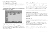
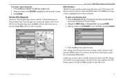
...the GPSMAP 2106/2110 & GPS 17 Installation Instructions for the Garmin unit and VHF radio to send and receive NMEA data from another user's DSC-capable VHF/GPS combination. Distress calls are broadcasted to all DSC users and appear with DSC output, you to sort and delete calls. 52 GPSMAP 2106/2110 Owner's... Manual You can select any DSC distress call within range. The Call List and Log sub tabs both show an Entry Review. DSC uses marine VHF radio and GPS technologies to the distress call. An alert message ...
...the GPSMAP 2106/2110 & GPS 17 Installation Instructions for the Garmin unit and VHF radio to send and receive NMEA data from another user's DSC-capable VHF/GPS combination. Distress calls are broadcasted to all DSC users and appear with DSC output, you to sort and delete calls. 52 GPSMAP 2106/2110 Owner's... Manual You can select any DSC distress call within range. The Call List and Log sub tabs both show an Entry Review. DSC uses marine VHF radio and GPS technologies to the distress call. An alert message ...
Owner's Manual
Page 61
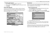
Press ENTER. The Directory Item Review window allows you return to the log, the new name appears under the corresponding MMSI number. Names cannot be sent like a phone book and can delete the displayed call. GPSMAP 2106/2110 Owner's Manual 53 Press up or down on the ROCKER to enter... all contacts by name and MMSI number. After creating a New Directory Item entry, the name created is only available in the GPS. From the DSC tab, highlight the Call List or Log sub tab. 2. Review DSC Waypoint The Review DSC Waypoint Page operates similarly to that particular MMSI number.
Press ENTER. The Directory Item Review window allows you return to the log, the new name appears under the corresponding MMSI number. Names cannot be sent like a phone book and can delete the displayed call. GPSMAP 2106/2110 Owner's Manual 53 Press up or down on the ROCKER to enter... all contacts by name and MMSI number. After creating a New Directory Item entry, the name created is only available in the GPS. From the DSC tab, highlight the Call List or Log sub tab. 2. Review DSC Waypoint The Review DSC Waypoint Page operates similarly to that particular MMSI number.

Owner's Manual
Page 94
...DSC support). Any DSC-equipped mariner (on sea or land) within range can receive the call (if you have...field before storing a waypoint. How Can Garmin Help You with the MMSI number attached to...2110 Owner's Manual Appendix > LORAN TD System Federal Users in the United States Federal users can obtain MMSI assignments from their ship station license. The LORAN (LOng RAnge Navigation) system covers the entire U.S.A. The GPSMAP unit automatically converts GPS... the VHF radio. These procedures are currently under review by obtaining or amending their agency radio spectrum management...
...DSC support). Any DSC-equipped mariner (on sea or land) within range can receive the call (if you have...field before storing a waypoint. How Can Garmin Help You with the MMSI number attached to...2110 Owner's Manual Appendix > LORAN TD System Federal Users in the United States Federal users can obtain MMSI assignments from their ship station license. The LORAN (LOng RAnge Navigation) system covers the entire U.S.A. The GPSMAP unit automatically converts GPS... the VHF radio. These procedures are currently under review by obtaining or amending their agency radio spectrum management...
Owner's Manual
Page 103
... 73 heading 60 highlight 8 Highway Page 41 options 41 I installation i invert route 25 GPSMAP 2106/2110 Owner's Manual 95 See DSC Dilution of Precision 88 distance units 60 distress calls 85 DOP... 88 DSC 52, 85 directory 53 distress call 52, 86 log 52 position report 52, 86 setup 54 DSC Item Review...function adjustments 33 function windows 33 G gain 76 gain setting 73 Go To Point 20 GPS accuracy alarm 57 GPS receiver initializing 5 GPS status icon 5 GPS tab 5, 43 GSD 20 i, 58, 72 GSD 21 58, 72 GSD 22 i,...
... 73 heading 60 highlight 8 Highway Page 41 options 41 I installation i invert route 25 GPSMAP 2106/2110 Owner's Manual 95 See DSC Dilution of Precision 88 distance units 60 distress calls 85 DOP... 88 DSC 52, 85 directory 53 distress call 52, 86 log 52 position report 52, 86 setup 54 DSC Item Review...function adjustments 33 function windows 33 G gain 76 gain setting 73 Go To Point 20 GPS accuracy alarm 57 GPS receiver initializing 5 GPS status icon 5 GPS tab 5, 43 GSD 20 i, 58, 72 GSD 21 58, 72 GSD 22 i,...
Owner's Manual
Page 104
...19 clearing 19 proximity waypoint list 18 Q QUICK NAV route 25 QUIT key 2 R re-evaluate route 25 receiver status 6 replace from card 55 review waypoint page 15 ROCKER key 2 routes 23-29 copying 25 creating 23 deleting 26 editing 26 navigating 24 ...simulator mode 7 setting up 87 using 86 M magnetic north 61 Main Menu 43-71 Card tab 54 Celestial tab 47 GPS tab 43 Highway tab 71 Messages tab 55 Network tab 64 overview 43 Pages tab 64 Points tab 49 Routes tab ... version 59 soft keys 3, 9 soft structure 73 Sonar understanding 72-81 sonar alarms 58 Sonar Page 74-77 GPSMAP 2106/2110 Owner's Manual
...19 clearing 19 proximity waypoint list 18 Q QUICK NAV route 25 QUIT key 2 R re-evaluate route 25 receiver status 6 replace from card 55 review waypoint page 15 ROCKER key 2 routes 23-29 copying 25 creating 23 deleting 26 editing 26 navigating 24 ...simulator mode 7 setting up 87 using 86 M magnetic north 61 Main Menu 43-71 Card tab 54 Celestial tab 47 GPS tab 43 Highway tab 71 Messages tab 55 Network tab 64 overview 43 Pages tab 64 Points tab 49 Routes tab ... version 59 soft keys 3, 9 soft structure 73 Sonar understanding 72-81 sonar alarms 58 Sonar Page 74-77 GPSMAP 2106/2110 Owner's Manual
Owner's Manual
Page 105
See WAAS wide beam 72 Z zoom 35, 41, 77 GPSMAP 2106/2110 Owner's Manual 97 Index adjustment menu 76 configuring 75 Sonar tab 78-81 sound waves 72 source, GPS 6 specifications 82 speed filter 58 speed units 60 status bar 3, 5 storage 87 strongest sonar returns 73 sun rise/set 47 surface clutter 73...water speed 79, 89 water temperature alarm 58 waypoints 13-25 creating 13 deleting 18 editing 15 marking 13, 78 moving 16 proximity 18 reviewing 15 underwater 78 using 13 waypoint list 17 waypoint name changing 16 waypoint symbol changing 16 weakest returns 73 whiteline 74, 76 Wide Area Augmentation...
See WAAS wide beam 72 Z zoom 35, 41, 77 GPSMAP 2106/2110 Owner's Manual 97 Index adjustment menu 76 configuring 75 Sonar tab 78-81 sound waves 72 source, GPS 6 specifications 82 speed filter 58 speed units 60 status bar 3, 5 storage 87 strongest sonar returns 73 sun rise/set 47 surface clutter 73...water speed 79, 89 water temperature alarm 58 waypoints 13-25 creating 13 deleting 18 editing 15 marking 13, 78 moving 16 proximity 18 reviewing 15 underwater 78 using 13 waypoint list 17 waypoint name changing 16 waypoint symbol changing 16 weakest returns 73 whiteline 74, 76 Wide Area Augmentation...


