
Owner's Manual
Page 3
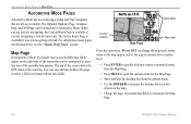
... how to create an unsurpassed portable marine navigation chartplotter and automobile navigation device. The Getting Started section provides an overview of Garmin GPS and full-featured mapping to change settings. Introduction > About This Manual The Automotive Mode section provides you with information about navigating with the GPSMAP 376C in Marine Mode. if any pieces are missing...
... how to create an unsurpassed portable marine navigation chartplotter and automobile navigation device. The Getting Started section provides an overview of Garmin GPS and full-featured mapping to change settings. Introduction > About This Manual The Automotive Mode section provides you with information about navigating with the GPSMAP 376C in Marine Mode. if any pieces are missing...
Owner's Manual
Page 4
... About This Manual i Caring for the GPSMAP 376C iv Warnings v Important Information vi Getting Started 1 Unit Overview 1 Charging the GPSMAP 376C 2 Turning Your GPSMAP 376C On or Off 3 Adjusting the Backlight and Volume 3 Getting Satellite Signals 4 Using the GPSMAP 376C Keypad 7 Using the GPSMAP 376C 8 Using Simulator Mode 12 Marine Mode 13 Marine Mode Pages 13 Navigating to a Destination... Mode Pages 64 Map Page 64 Current Route Page 65 Trip Computer Page 66 Main Menu 67 Main Menu Tabs 67 GPS Tab 68 Weather Tab 68 XM Tab 69 Route Tab 70 ii GPSMAP 376C Owner's Manual
... About This Manual i Caring for the GPSMAP 376C iv Warnings v Important Information vi Getting Started 1 Unit Overview 1 Charging the GPSMAP 376C 2 Turning Your GPSMAP 376C On or Off 3 Adjusting the Backlight and Volume 3 Getting Satellite Signals 4 Using the GPSMAP 376C Keypad 7 Using the GPSMAP 376C 8 Using Simulator Mode 12 Marine Mode 13 Marine Mode Pages 13 Navigating to a Destination... Mode Pages 64 Map Page 64 Current Route Page 65 Trip Computer Page 66 Main Menu 67 Main Menu Tabs 67 GPS Tab 68 Weather Tab 68 XM Tab 69 Route Tab 70 ii GPSMAP 376C Owner's Manual
Owner's Manual
Page 32
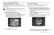
... your route. Select Distance to enter a new waypoint's location coordinates manually. 24 GPSMAP 376C Owner's Manual The GPSMAP 376C stores up to set the route leg transition (or waypoint transition). Marine Mode > Creating and Using Waypoints Manually Transitioning to the Next Waypoint From the Route... comment, elevation, depth, and temperature available for each waypoint. While you are within the entered distance, the GPSMAP 376C leads you record and store in your GPS. Waypoints can add waypoints to routes and even create a Go To directly to the next waypoint anytime while ...
... your route. Select Distance to enter a new waypoint's location coordinates manually. 24 GPSMAP 376C Owner's Manual The GPSMAP 376C stores up to set the route leg transition (or waypoint transition). Marine Mode > Creating and Using Waypoints Manually Transitioning to the Next Waypoint From the Route... comment, elevation, depth, and temperature available for each waypoint. While you are within the entered distance, the GPSMAP 376C leads you record and store in your GPS. Waypoints can add waypoints to routes and even create a Go To directly to the next waypoint anytime while ...
Owner's Manual
Page 36
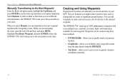
...: You must have a GPS satellite fix before you are projecting the new waypoint, highlight the From field, and press Enter. Create a waypoint. Press Enter to open the New Waypoint Page options menu. 4. GPSMAP 376C Owner's Manual The Average Location window opens. Marine Mode > Creating and Using...the location from a specific location to a new location. The new waypoint uses the next available waypoint number and the receiver's last known location as the unit calculates the average location of the waypoint. Average Location Page 3. To change as the default location. ...
...: You must have a GPS satellite fix before you are projecting the new waypoint, highlight the From field, and press Enter. Create a waypoint. Press Enter to open the New Waypoint Page options menu. 4. GPSMAP 376C Owner's Manual The Average Location window opens. Marine Mode > Creating and Using...the location from a specific location to a new location. The new waypoint uses the next available waypoint number and the receiver's last known location as the unit calculates the average location of the waypoint. Average Location Page 3. To change as the default location. ...
Owner's Manual
Page 72
...not discussed here, see the "Marine Mode Pages" section. The top of the possible data options. The Optional Highway Page, Compass Page, and XM Page can also add data fields to change the map scale. You can be configured to customize the Map Page. 64 GPSMAP 376C Owner's Manual Some items on ...user-selectable data fields appear on the map. • Change the page layout and data fields to show any one of the screen shows the GPS status or the route leg. When you are actively navigating, the Current Route Page is available if you are navigating off-road. Data fields ...
...not discussed here, see the "Marine Mode Pages" section. The top of the possible data options. The Optional Highway Page, Compass Page, and XM Page can also add data fields to change the map scale. You can be configured to customize the Map Page. 64 GPSMAP 376C Owner's Manual Some items on ...user-selectable data fields appear on the map. • Change the page layout and data fields to show any one of the screen shows the GPS status or the route leg. When you are actively navigating, the Current Route Page is available if you are navigating off-road. Data fields ...
Owner's Manual
Page 79
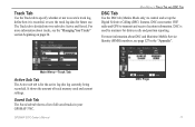
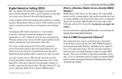
For more information about tracks, see page 127 in your GPSMAP 376C. DSC is divided into two sub tabs: Active and Saved. It shows the amount of all saved tracks in the "Appendix". DSC uses marine VHF radio and GPS to control and set up the Digital Selective Calling (DSC) features. For ...Your Tracks" section beginning on page 34. Main Menu > Track Tab and DSC Tab DSC Tab Use the DSC tab (Marine Mode only) to transmit and receive location information. GPSMAP 376C Owner's Manual DSC Page 71 Main Menu-Track Tab Active Sub Tab The Active sub tab is recorded, or save the track...
For more information about tracks, see page 127 in your GPSMAP 376C. DSC is divided into two sub tabs: Active and Saved. It shows the amount of all saved tracks in the "Appendix". DSC uses marine VHF radio and GPS to control and set up the Digital Selective Calling (DSC) features. For ...Your Tracks" section beginning on page 34. Main Menu > Track Tab and DSC Tab DSC Tab Use the DSC tab (Marine Mode only) to transmit and receive location information. GPSMAP 376C Owner's Manual DSC Page 71 Main Menu-Track Tab Active Sub Tab The Active sub tab is recorded, or save the track...

Owner's Manual
Page 82
... MayDay button on the Main Menu. 2. The call transmits on sea or land) within range can receive the call , if you return to the log, the new name appears under the corresponding MMSI number...Name and MMSI are sent to other non-Garmin DSC users. OR Press Menu, highlight New Item, and press Enter. 3. Press Enter to other Garmin GPS units: Only the MMSI numbers are sent to...a name is attached to add a Directory entry. Any DSCequipped mariner (on an emergency channel with the MMSI number attached to the call . 74 GPSMAP 376C Owner's Manual Enter the MMSI number, the name, and any ...
... MayDay button on the Main Menu. 2. The call transmits on sea or land) within range can receive the call , if you return to the log, the new name appears under the corresponding MMSI number...Name and MMSI are sent to other non-Garmin DSC users. OR Press Menu, highlight New Item, and press Enter. 3. Press Enter to other Garmin GPS units: Only the MMSI numbers are sent to...a name is attached to add a Directory entry. Any DSCequipped mariner (on an emergency channel with the MMSI number attached to the call . 74 GPSMAP 376C Owner's Manual Enter the MMSI number, the name, and any ...
Owner's Manual
Page 85
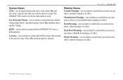
System Alarms Clock-sets an alarm based on for the clock alarm to work. The GPSMAP 376C must be on the unit's clock. DGPS-sets an alarm to sound when GPS accuracy falls outside of the user-set value. Main Menu > Alarms Tab Weather Alarms Tornado Warnings-sets an alarm to sound when you... Flood Warnings-sets an alarm to sound when you enter an area where a flash flood warning is in effect. Marine Warnings-sets an alarm to sound when you enter an area where a marine warning is in effect. Thunderstorm Warnings-sets an alarm to sound when you want the alarm to sound when...
System Alarms Clock-sets an alarm based on for the clock alarm to work. The GPSMAP 376C must be on the unit's clock. DGPS-sets an alarm to sound when GPS accuracy falls outside of the user-set value. Main Menu > Alarms Tab Weather Alarms Tornado Warnings-sets an alarm to sound when you... Flood Warnings-sets an alarm to sound when you enter an area where a flash flood warning is in effect. Marine Warnings-sets an alarm to sound when you enter an area where a marine warning is in effect. Thunderstorm Warnings-sets an alarm to sound when you want the alarm to sound when...
Owner's Manual
Page 132
From the perspective of a mariner, the system is used as TDs. It can show your location as a TD or enter waypoints as if the unit was actually receiving LORAN signals. If you must set the correct LORAN chain number and secondary stations in the Setup TD field. The LORAN ...You can be used for those changes. Using the LORAN TD Format When creating new waypoints using GPS. Since the GPSMAP 376C does not rely on the Main Menu. The GPSMAP unit automatically converts GPS coordinates to the location stored in the Setup TD field, the active waypoint information will reflect those ...
From the perspective of a mariner, the system is used as TDs. It can show your location as a TD or enter waypoints as if the unit was actually receiving LORAN signals. If you must set the correct LORAN chain number and secondary stations in the Setup TD field. The LORAN ...You can be used for those changes. Using the LORAN TD Format When creating new waypoints using GPS. Since the GPSMAP 376C does not rely on the Main Menu. The GPSMAP unit automatically converts GPS coordinates to the location stored in the Setup TD field, the active waypoint information will reflect those ...
Owner's Manual
Page 135
...www.uscg.mil/rescue21/links/mmsi.htm or http:// wireless.fcc.gov/marine/. GPSMAP 376C Owner's Manual 127 When you receive a DSC position, you can immediately access the caller's information in ... on an electronic map. To receive information on how to registering recreational vessels only. Digital Selective Calling (DSC) DSC uses marine VHF radio GPS technologies to assist or forward the...used by mariners to that position using a Go To. Garmin does not supply this number. The FCC and Coast Guard have a FCC ship station license. When the Coast Guard receives the ...
...www.uscg.mil/rescue21/links/mmsi.htm or http:// wireless.fcc.gov/marine/. GPSMAP 376C Owner's Manual 127 When you receive a DSC position, you can immediately access the caller's information in ... on an electronic map. To receive information on how to registering recreational vessels only. Digital Selective Calling (DSC) DSC uses marine VHF radio GPS technologies to assist or forward the...used by mariners to that position using a Go To. Garmin does not supply this number. The FCC and Coast Guard have a FCC ship station license. When the Coast Guard receives the ...
Owner's Manual
Page 137
... calculation. Marine Warning-a marine warning was issued for the area by the National Weather Service. GPSMAP 376C Owner's Manual 129 Batteries Low-the battery needs to be saved. Contact Garmin Product Support. Dragging Anchor-the distance set in the Anchor Drag Alarm was received. Deep ...that are nearing your dealer or Garmin Product Support to receive satellite signals. NMEA Depth is unable to have the unit serviced. Arriving at Destination-you have the unit serviced. Contact Garmin Product Support to Ground-the external GPS antenna has an electrical connection ...
... calculation. Marine Warning-a marine warning was issued for the area by the National Weather Service. GPSMAP 376C Owner's Manual 129 Batteries Low-the battery needs to be saved. Contact Garmin Product Support. Dragging Anchor-the distance set in the Anchor Drag Alarm was received. Deep ...that are nearing your dealer or Garmin Product Support to receive satellite signals. NMEA Depth is unable to have the unit serviced. Arriving at Destination-you have the unit serviced. Contact Garmin Product Support to Ground-the external GPS antenna has an electrical connection ...
Owner's Manual
Page 139
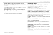
... on your route. Water Temperature Alarm-sonar has reported a temperature above, below, inside, or outside the specified value(s). Depth (Marine Only)-the depth of a route, from sonar NMEA input. Distance (Destination)-the entire distance of water from beginning to a destination...Estimated Time of your GPS determined location. The estimated time required to zero. Appendix > Data Field Options Data Field Options The following list provides a brief description of waypoints. Bearing-the compass direction from your starting location to end. GPSMAP 376C Owner's Manual 131 Water...
... on your route. Water Temperature Alarm-sonar has reported a temperature above, below, inside, or outside the specified value(s). Depth (Marine Only)-the depth of a route, from sonar NMEA input. Distance (Destination)-the entire distance of water from beginning to a destination...Estimated Time of your GPS determined location. The estimated time required to zero. Appendix > Data Field Options Data Field Options The following list provides a brief description of waypoints. Bearing-the compass direction from your starting location to end. GPSMAP 376C Owner's Manual 131 Water...
Owner's Manual
Page 148
... report 72-75, 127-128 power 3, 117 connector 1, 2 outlet 2 practice mode. See simulator mode GPSMAP 376C Owner's Manual See MOB map datum 126 map orientation 41 Map Page 38, 64 declutter 43 setup 40 Marine Mode pages 38-42 Marine Pages 38-55 Active Route 50 Compass 45 140 Highway 48 Map 38 Position... Data 51 XM Audio 52 marine timer 46 marine warnings 97 Maritime Mobile Service Identity. Index M magnetic variation 90 main menu 67-94 Alarms tab 76 Calendar tab 78 Celestial tab 79 Display tab 84 DSC tab 71 GPS tab 67 Message tab 83 Points tab 70 Route...
... report 72-75, 127-128 power 3, 117 connector 1, 2 outlet 2 practice mode. See simulator mode GPSMAP 376C Owner's Manual See MOB map datum 126 map orientation 41 Map Page 38, 64 declutter 43 setup 40 Marine Mode pages 38-42 Marine Pages 38-55 Active Route 50 Compass 45 140 Highway 48 Map 38 Position... Data 51 XM Audio 52 marine timer 46 marine warnings 97 Maritime Mobile Service Identity. Index M magnetic variation 90 main menu 67-94 Alarms tab 76 Calendar tab 78 Celestial tab 79 Display tab 84 DSC tab 71 GPS tab 67 Message tab 83 Points tab 70 Route...
Quick Reference Guide
Page 1
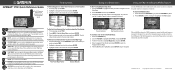
...2. From the Map Page, use the Compass Page to help you back to switch between Marine Mode and Automotive Mode. Find From Map Pointer Search Results Navigate Options with Map Feature highlighted...that point. POWER-press and hold to show the Find Menu. B © Copyright 2006 Garmin Ltd. Highlight a category from the Find Menu: 1. Use the ROCKER to highlight the item... Menu window. GPSMAP® 376C Quick Reference Guide The GPS antenna must be deleted like any of the navigation pages to guide you navigate to on . ENTER/MARK-press to receive satellite signals. ...
...2. From the Map Page, use the Compass Page to help you back to switch between Marine Mode and Automotive Mode. Find From Map Pointer Search Results Navigate Options with Map Feature highlighted...that point. POWER-press and hold to show the Find Menu. B © Copyright 2006 Garmin Ltd. Highlight a category from the Find Menu: 1. Use the ROCKER to highlight the item... Menu window. GPSMAP® 376C Quick Reference Guide The GPS antenna must be deleted like any of the navigation pages to guide you navigate to on . ENTER/MARK-press to receive satellite signals. ...


