Installation Instructions
Page 7
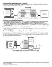
...To select between visual and audible alerts, install a switch. GPSMAP 400/500 Series Installation Instructions 7 Refer to the wiring diagram for wire identification. 2. For Garmin devices, the ground (black) wires serve as NMEA 0183 ground and must be used with a lamp, a horn, or both, to sound or flash ... limit the current from the GPSMAP 400/500 wiring harness to the NMEA 0183 in (or Rx/A +) wire on the same terminal as a DSC or AIS device. GPSMAP 400/500 series chartplotter Wire color Fuse 3 A Red Black (ground) + - Battery Wire color 10-32 Vdc* Fuse 3 A Red (...
...To select between visual and audible alerts, install a switch. GPSMAP 400/500 Series Installation Instructions 7 Refer to the wiring diagram for wire identification. 2. For Garmin devices, the ground (black) wires serve as NMEA 0183 ground and must be used with a lamp, a horn, or both, to sound or flash ... limit the current from the GPSMAP 400/500 wiring harness to the NMEA 0183 in (or Rx/A +) wire on the same terminal as a DSC or AIS device. GPSMAP 400/500 series chartplotter Wire color Fuse 3 A Red Black (ground) + - Battery Wire color 10-32 Vdc* Fuse 3 A Red (...

Installation Instructions
Page 11
...21146 USA www.nmea.org GPSMAP 400/500 Series Installation Instructions 11 Water Referenced Water Depth AIS Class A Position Report AIS Class B Position Report AIS Class B Extended Position Report AIS Class A Static and Voyage Related Data Radio Frequency/Mode/Power DSC Call Information Wind ... Group Function Transmit/Receive PGN List Group Function Product Information Vessel Heading Engine Parameters - Communication NMEA 2000 PGN Information (Only Applicable to peak) Frequency: 50/200 kHz (dual frequency and 1 kW), 80/200 kHz (dual beam) Depth: 2,500 ft. (762 m) (1 kW), 1,500 ft (...
...21146 USA www.nmea.org GPSMAP 400/500 Series Installation Instructions 11 Water Referenced Water Depth AIS Class A Position Report AIS Class B Position Report AIS Class B Extended Position Report AIS Class A Static and Voyage Related Data Radio Frequency/Mode/Power DSC Call Information Wind ... Group Function Transmit/Receive PGN List Group Function Product Information Vessel Heading Engine Parameters - Communication NMEA 2000 PGN Information (Only Applicable to peak) Frequency: 50/200 kHz (dual frequency and 1 kW), 80/200 kHz (dual beam) Depth: 2,500 ft. (762 m) (1 kW), 1,500 ft (...

Owner's Manual
Page 5
...Viewing System Information 48 Configuring System Settings 48 Configuring Units of Measure 49 Changing the System Language 49 Configuring Navigation Preferences 50 Configuring Communications Settings 51 Setting Alarms 53 Setting the Total Fuel Onboard Alarm 54 Configuring My Boat 55 Configuring Other ... Man-Overboard Distress Calls Initiated from the Chartplotter 64 Position Tracking 64 Placing an Individual Routine Call 65 Calling an AIS Target 66 Appendix 67 Specifications 67 Alarms and Messages 69 Capturing Screenshots 72 Caring for the Unit 72 Software License Agreement...
...Viewing System Information 48 Configuring System Settings 48 Configuring Units of Measure 49 Changing the System Language 49 Configuring Navigation Preferences 50 Configuring Communications Settings 51 Setting Alarms 53 Setting the Total Fuel Onboard Alarm 54 Configuring My Boat 55 Configuring Other ... Man-Overboard Distress Calls Initiated from the Chartplotter 64 Position Tracking 64 Placing an Individual Routine Call 65 Calling an AIS Target 66 Appendix 67 Specifications 67 Alarms and Messages 69 Capturing Screenshots 72 Caring for the Unit 72 Software License Agreement...

Owner's Manual
Page 8
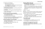
...the language to display on your unit, you have NMEA 0183 devices connected to a serial port, specify which ports are connected. AIS Receiver (not available if you select None for location readings. Position Format-specify the coordinate system to use for NMEA Devices)-Select Yes...2 GPSMAP 400/500 Series Owner's Manual Store Demonstration-select Off. (This option is only available the first time the unit is an AIS (Automatic Identification System) receiver. Time Format-specify whether you must configure the initial settings. Home Screen Initializing Unit Settings The first time ...
...the language to display on your unit, you have NMEA 0183 devices connected to a serial port, specify which ports are connected. AIS Receiver (not available if you select None for location readings. Position Format-specify the coordinate system to use for NMEA Devices)-Select Yes...2 GPSMAP 400/500 Series Owner's Manual Store Demonstration-select Off. (This option is only available the first time the unit is an AIS (Automatic Identification System) receiver. Time Format-specify whether you must configure the initial settings. Home Screen Initializing Unit Settings The first time ...
Owner's Manual
Page 9
...selected for depth, temperature, distance, speed, elevation, volume, and pressure. Refer to your boat (page 56). AIS Alarm Range-select the distance at which an alarm will sound if an AIS vessel nears your boat specifications for on the Rocker to adjust the brightness. If a water speed wheel is ...Water Alarm-only available if you want to calibrate it now. Refer to your boat (page 56). AIS Alarm Time To-select the time within which an alarm will sound if an AIS vessel is automatically set the time zone you are receiving NMEA sonar depth data. System Units-specify ...
...selected for depth, temperature, distance, speed, elevation, volume, and pressure. Refer to your boat (page 56). AIS Alarm Range-select the distance at which an alarm will sound if an AIS vessel nears your boat specifications for on the Rocker to adjust the brightness. If a water speed wheel is ...Water Alarm-only available if you want to calibrate it now. Refer to your boat (page 56). AIS Alarm Time To-select the time within which an alarm will sound if an AIS vessel is automatically set the time zone you are receiving NMEA sonar depth data. System Units-specify ...
Owner's Manual
Page 14
Stop Navigation-stop navigating to an external AIS (Automatic Identification System) or DSC (Digital Selective Calling) device (page 62). Data bars 8 GPSMAP 400/500 Series Owner's Manual Other Vessels-view information about other ...
Stop Navigation-stop navigating to an external AIS (Automatic Identification System) or DSC (Digital Selective Calling) device (page 62). Data bars 8 GPSMAP 400/500 Series Owner's Manual Other Vessels-view information about other ...

Owner's Manual
Page 21
... anchorages. Mariner's Eye 3D Navigation Chart Press the Range (+) key to move the view away from above and behind the boat (according to an external AIS (Automatic Identification System) or DSC (Digital Selective Calling) device (page 62). Press the Range (-) key to move the view closer to your unit must be...
... anchorages. Mariner's Eye 3D Navigation Chart Press the Range (+) key to move the view away from above and behind the boat (according to an external AIS (Automatic Identification System) or DSC (Digital Selective Calling) device (page 62). Press the Range (-) key to move the view closer to your unit must be...
Owner's Manual
Page 47
...other boats, your chartplotter, select Information > User Data > Clear User Data. 2. DSC List-view the 100 most -recent call in the Garmin\UserData folder. 2. Select Options > Delete All to identify and track other boats from the list. Select Add Contact. 2. Complete one of ...the calls from the Home screen, select Information > Other Vessels. To add a DSC contact: 1. Automatic Identification System The Automatic Identification System (AIS) enables you to delete all waypoints, routes, and tracks: 1. See page 62 for more information. If a second call was received. Enter ...
...other boats, your chartplotter, select Information > User Data > Clear User Data. 2. DSC List-view the 100 most -recent call in the Garmin\UserData folder. 2. Select Options > Delete All to identify and track other boats from the list. Select Add Contact. 2. Complete one of ...the calls from the Home screen, select Information > Other Vessels. To add a DSC contact: 1. Automatic Identification System The Automatic Identification System (AIS) enables you to delete all waypoints, routes, and tracks: 1. See page 62 for more information. If a second call was received. Enter ...

Owner's Manual
Page 48
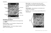
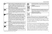
... emergency position reports when activated. The direction in which the triangle is pointing indicates the direction in which the AIS vessel is reporting AIS information. When connected to area traffic. The information reported for collision avoidance, you track a SART transmission to the ...nearest approach. Lost AIS target Tracking AIS target AIS vessel Dangerous AIS target Closest point and time of the vessel was reported, the nearest approach, and the time to locate and assist...
... emergency position reports when activated. The direction in which the triangle is pointing indicates the direction in which the AIS vessel is reporting AIS information. When connected to area traffic. The information reported for collision avoidance, you track a SART transmission to the ...nearest approach. Lost AIS target Tracking AIS target AIS vessel Dangerous AIS target Closest point and time of the vessel was reported, the nearest approach, and the time to locate and assist...
Owner's Manual
Page 49
...with a red line attached to the target indicates the heading of the target. GPSMAP 400/500 Series Owner's Manual Viewing Information AIS-SART transmission. Changes in range. Dangerous target in the speed, the course over ground and heading information are provided by the ...a dashed line on the value of their SART device, and does not represent a true emergency. A red X indicates that target. AIS-SART transmission lost , and the chartplotter displays a message banner asking whether the vessel should continue to see more information about the SART transmission...
...with a red line attached to the target indicates the heading of the target. GPSMAP 400/500 Series Owner's Manual Viewing Information AIS-SART transmission. Changes in range. Dangerous target in the speed, the course over ground and heading information are provided by the ...a dashed line on the value of their SART device, and does not represent a true emergency. A red X indicates that target. AIS-SART transmission lost , and the chartplotter displays a message banner asking whether the vessel should continue to see more information about the SART transmission...

Owner's Manual
Page 50
... MMSI Heading Target with Course over Ground, Heading, and Rate of Turn When course over ground and heading information are provided by an activated AIS target, the projected course of test alerts and symbols in which the target is turning, which is also based on the rate-of-turn ...information, is calculated based on the course over ground, heading, and rate-of-turn information is calculated based on by an activated AIS target, but rate-of-turn information are provided by default. The length of the target is not provided, the projected course of the barb ...
... MMSI Heading Target with Course over Ground, Heading, and Rate of Turn When course over ground and heading information are provided by an activated AIS target, the projected course of test alerts and symbols in which the target is turning, which is also based on the rate-of-turn ...information, is calculated based on the course over ground, heading, and rate-of-turn information is calculated based on by an activated AIS target, but rate-of-turn information are provided by default. The length of the target is not provided, the projected course of the barb ...

Owner's Manual
Page 51
...3D. 3. Heading-allows you to that appears using a trail. Press SELECT. 4. GPSMAP 400/500 Series Owner's Manual 45 You can view the AIS signal status, MMSI, GPS speed, GPS heading, and other information that is applied only to that chart or to enter the projected heading time for...in map supports Fishing charts. 1. Select a distance or select Show All. Viewing Information • Details-shows or hides details about a Targeted AIS Vessel You can configure how other vessels. Fishing charts are available if you use a BlueChart g2 Vision SD card or if your built-in map...
...3D. 3. Heading-allows you to that appears using a trail. Press SELECT. 4. GPSMAP 400/500 Series Owner's Manual 45 You can view the AIS signal status, MMSI, GPS speed, GPS heading, and other information that is applied only to that chart or to enter the projected heading time for...in map supports Fishing charts. 1. Select a distance or select Show All. Viewing Information • Details-shows or hides details about a Targeted AIS Vessel You can configure how other vessels. Fishing charts are available if you use a BlueChart g2 Vision SD card or if your built-in map...

Owner's Manual
Page 52
...SD card or if your built-in map supports Fishing charts. 46 GPSMAP 400/500 Series Owner's Manual Select AIS Vessel. Select AIS Vessel > Deactivate. The safe zone is used for an AIS Vessel Note: Mariner's Eye 3D charts are available only if you use a BlueChart g2 Vision SD card. ...Select Navigation Chart, Fishing Chart, Perspective 3D, or Mariner's Eye 3D. 3. Select MENU > Other Vessels > AIS Alarm > On. Select Range to set the measured radius of AIS Targets Note: Mariner's Eye 3D charts and Fish Eye 3D charts are available only if you use a BlueChart g2 Vision...
...SD card or if your built-in map supports Fishing charts. 46 GPSMAP 400/500 Series Owner's Manual Select AIS Vessel. Select AIS Vessel > Deactivate. The safe zone is used for an AIS Vessel Note: Mariner's Eye 3D charts are available only if you use a BlueChart g2 Vision SD card. ...Select Navigation Chart, Fishing Chart, Perspective 3D, or Mariner's Eye 3D. 3. Select MENU > Other Vessels > AIS Alarm > On. Select Range to set the measured radius of AIS Targets Note: Mariner's Eye 3D charts and Fish Eye 3D charts are available only if you use a BlueChart g2 Vision...
Owner's Manual
Page 53
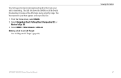
From the Home screen, select Charts. 2. Select Navigation Chart, Fishing Chart, Perspective 3D, or Mariner's Eye 3D. 3. Select MENU > Other Vessels > AIS List. The AIS target list shows information about all of the boats your boat appears at the top of the AIS boats and is monitoring. The boat nearest to an AIS Target See "Calling an AIS Target" (page 66). Making a Call to your unit is sorted by range. GPSMAP 400/500 Series Owner's Manual Viewing Information 47 The AIS list shows the MMSIs or (if the boat is broadcasting it) names of the list. 1.
From the Home screen, select Charts. 2. Select Navigation Chart, Fishing Chart, Perspective 3D, or Mariner's Eye 3D. 3. Select MENU > Other Vessels > AIS List. The AIS target list shows information about all of the boats your boat appears at the top of the AIS boats and is monitoring. The boat nearest to an AIS Target See "Calling an AIS Target" (page 66). Making a Call to your unit is sorted by range. GPSMAP 400/500 Series Owner's Manual Viewing Information 47 The AIS list shows the MMSIs or (if the boat is broadcasting it) names of the list. 1.
Owner's Manual
Page 57
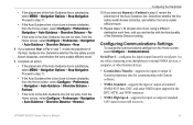
... placement of the Auto Guidance line. Repeat steps 1-10 at least once more, using a different destination each time, until you are familiar with Garmin software. • NMEA Standard-supports the input or output of standard NMEA 0183 data, DSC, and sonar NMEA input support for the DPT, ...; If the Auto Guidance line is too close to external NMEA devices, a computer, or other Garmin devices. • Garmin Data Transfer-supports the input or output of Garmin-proprietary data for most AIS receivers. If you selected Nearest or Farthest in the Auto Guidance line are too wide, from the...
... placement of the Auto Guidance line. Repeat steps 1-10 at least once more, using a different destination each time, until you are familiar with Garmin software. • NMEA Standard-supports the input or output of standard NMEA 0183 data, DSC, and sonar NMEA input support for the DPT, ...; If the Auto Guidance line is too close to external NMEA devices, a computer, or other Garmin devices. • Garmin Data Transfer-supports the input or output of Garmin-proprietary data for most AIS receivers. If you selected Nearest or Farthest in the Auto Guidance line are too wide, from the...
Owner's Manual
Page 62
...unit reboots and prompts you have entered. 1. The zone can be displayed. to 2.0 mi). • Time to (Safe Zone)-sounds an alarm if AIS or MARPA determines that are within the defined time interval (from 1 to adjust unit settings (page 2). 56 GPSMAP 400/500 Series Owner's Manual Select Yes... the Chartplotter Fuel Capacity-enter the total fuel capacity of the safe-zone ring to a specified distance from 500 ft. NOTE: To configure AIS or DSC information for boats other boats, your boat for boats that a target will intersect the safe zone within range and equipped with a ...
...unit reboots and prompts you have entered. 1. The zone can be displayed. to 2.0 mi). • Time to (Safe Zone)-sounds an alarm if AIS or MARPA determines that are within the defined time interval (from 1 to adjust unit settings (page 2). 56 GPSMAP 400/500 Series Owner's Manual Select Yes... the Chartplotter Fuel Capacity-enter the total fuel capacity of the safe-zone ring to a specified distance from 500 ft. NOTE: To configure AIS or DSC information for boats other boats, your boat for boats that a target will intersect the safe zone within range and equipped with a ...

Owner's Manual
Page 72
... more information on selecting a channel other than the default channel (Channel 72), see (page 65). Select AIS Vessel > Call with Radio. 4. On your Garmin VHF radio, select Call. On your Garmin VHF radio, select Call. 66 GPSMAP 400/500 Series Owner's Manual Select the station to call from the... Send to send the information about the call to the radio. 5. Calling an AIS Target When you connect your Garmin chartplotter to a Garmin VHF NMEA 2000-compatible radio, you can use the Rocker to select an AIS target . 2. Digital Selective Calling To make an individual routine call to an...
... more information on selecting a channel other than the default channel (Channel 72), see (page 65). Select AIS Vessel > Call with Radio. 4. On your Garmin VHF radio, select Call. On your Garmin VHF radio, select Call. 66 GPSMAP 400/500 Series Owner's Manual Select the station to call from the... Send to send the information about the call to the radio. 5. Calling an AIS Target When you connect your Garmin chartplotter to a Garmin VHF NMEA 2000-compatible radio, you can use the Rocker to select an AIS target . 2. Digital Selective Calling To make an individual routine call to an...

Owner's Manual
Page 75
Alarms and Messages The unit uses an on the data card is not unlocked for your chartplotter. AIS: Dangerous Target-shows the MMSI (Maritime Mobile Service Identity) of the antenna wiring is crimped, broken, or contacting the chassis. Battery Alarm-battery voltage ...has fallen below the value entered in your dealer or Garmin Product Support if the problem persists. remove and reinsert. voltage value in the Battery Alarm setup is Shorted-a part of the dangerous target. Card Needed...
Alarms and Messages The unit uses an on the data card is not unlocked for your chartplotter. AIS: Dangerous Target-shows the MMSI (Maritime Mobile Service Identity) of the antenna wiring is crimped, broken, or contacting the chassis. Battery Alarm-battery voltage ...has fallen below the value entered in your dealer or Garmin Product Support if the problem persists. remove and reinsert. voltage value in the Battery Alarm setup is Shorted-a part of the dangerous target. Card Needed...

Owner's Manual
Page 80
... apparent wind 36 74 Appearance 60 arrival alarms 53 Auto Magnetic 49 automatic guidance 21, 50 autopilot 30 Auto Power 48 B backing up data 40 backlight adjusting 3 barometer, reference... Color Scheme 61 Communications 51 Compass 31 compass rose 12 Compass Tape 9 contact information, Garmin iv coordinates, grid creating waypoints using 25 course up 12 current stations 38 customizing chart ...delete a waypoint 26 depth line 60 Depth Log 59 depth waypoint 61 detail 12 details, AIS vessels 45 Device List 52 Display 48 distance, measuring 26 Distress Calls 63 DSC 56, ...
... apparent wind 36 74 Appearance 60 arrival alarms 53 Auto Magnetic 49 automatic guidance 21, 50 autopilot 30 Auto Power 48 B backing up data 40 backlight adjusting 3 barometer, reference... Color Scheme 61 Communications 51 Compass 31 compass rose 12 Compass Tape 9 contact information, Garmin iv coordinates, grid creating waypoints using 25 course up 12 current stations 38 customizing chart ...delete a waypoint 26 depth line 60 Depth Log 59 depth waypoint 61 detail 12 details, AIS vessels 45 Device List 52 Display 48 distance, measuring 26 Distress Calls 63 DSC 56, ...

Owner's Manual
Page 82
...60 setting up 60-61 setup 60 specifications 68 split frequency 58 split zoom 58 temperature log 59 specifications 67 Speed Filter 48 Speed Sources 50 Split Frequency 58 Split Zoom 58 spot depths 13 Surface Noise 60 symbols 13 System Alarms 53 System Information 48 viewing 48 system settings 48...49 T Temp Log 59 Temp Offset 55 Tides/Currents 11 Animated 11 tide stations 37 viewing information 11 Time (options) 49 tracks 17, 28 trails AIS 45 DSC 65 transducer dual frequency 61 transferring data 39, 40 True (north) 49 true wind 36 turn the unit off 2 Turn Transition...
...60 setting up 60-61 setup 60 specifications 68 split frequency 58 split zoom 58 temperature log 59 specifications 67 Speed Filter 48 Speed Sources 50 Split Frequency 58 Split Zoom 58 spot depths 13 Surface Noise 60 symbols 13 System Alarms 53 System Information 48 viewing 48 system settings 48...49 T Temp Log 59 Temp Offset 55 Tides/Currents 11 Animated 11 tide stations 37 viewing information 11 Time (options) 49 tracks 17, 28 trails AIS 45 DSC 65 transducer dual frequency 61 transferring data 39, 40 True (north) 49 true wind 36 turn the unit off 2 Turn Transition...


