Manual - English
Page 14
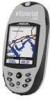
... instantaneously shown on your eXplorist automatically updates the route, providing you with up camp for that straight path. Press the MARK button and set up -to-date information about getting to "Camp". Next year, you want to the points of your hiking is selected by pressing the MARK button. ...GOTO button and select "Camp" from the points of the GOTO button. Next year, you with just a press of interest database. Using the eXplorist 500 7 Step Two: Where Do You Want To Go? There are on doing some nature exploring and you instructions to this same spot. Unless ...
... instantaneously shown on your eXplorist automatically updates the route, providing you with up camp for that straight path. Press the MARK button and set up -to-date information about getting to "Camp". Next year, you want to the points of your hiking is selected by pressing the MARK button. ...GOTO button and select "Camp" from the points of the GOTO button. Next year, you with just a press of interest database. Using the eXplorist 500 7 Step Two: Where Do You Want To Go? There are on doing some nature exploring and you instructions to this same spot. Unless ...
Manual - English
Page 19
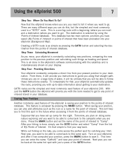
...Select Region. This displays a list of the Map screen represents your present position better. Starting Up The Satellite Status screen will continuously update, and you will be able to graphically see your position. With the region highlighted, press the ENTER button. Use the Arrow joystick ...to highlight the area that applies to track the satellites within a few minutes: If the eXplorist determines that you can see how well your eXplorist is performing. 12 When the eXplorist has enough information to compute a position fix, the Satellite Status screen is unable to you, ...
...Select Region. This displays a list of the Map screen represents your present position better. Starting Up The Satellite Status screen will continuously update, and you will be able to graphically see your position. With the region highlighted, press the ENTER button. Use the Arrow joystick ...to highlight the area that applies to track the satellites within a few minutes: If the eXplorist determines that you can see how well your eXplorist is performing. 12 When the eXplorist has enough information to compute a position fix, the Satellite Status screen is unable to you, ...

Manual - English
Page 52
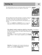
...your route will also occur during multi-leg routes so you always know which way you need to your destination. The Compass screen will be updated with a GOTO route active. If you already have a GOTO you have created. Routes 45 Creating a GOTO Route The instructions here describe ... the planned course. So even if you can be route. Notice the After you will notice a second line appearing that displayed, updated as the destination in the Points of Interest section of this manual. 3. Note: Detailed instructions for searching the POI database can 't follow .
...your route will also occur during multi-leg routes so you always know which way you need to your destination. The Compass screen will be updated with a GOTO route active. If you already have a GOTO you have created. Routes 45 Creating a GOTO Route The instructions here describe ... the planned course. So even if you can be route. Notice the After you will notice a second line appearing that displayed, updated as the destination in the Points of Interest section of this manual. 3. Note: Detailed instructions for searching the POI database can 't follow .

Manual - English
Page 53
...and press ENTER. 5. After you press ENTER, the last viewed navigation screen will be displayed, updated as needed to provide information about the GOTO route you want to use the Arrow joystick, causing the eXplorist to the current cursor position. Confirm that you want to deactivate it and create a new ...GOTO route. Highlight Yes. (If you highlight No and press ENTER, the eXplorist assumes that you want to create a GOTO from the Map Cursor This will create a GOTO route to a point on the map that you still ...
...and press ENTER. 5. After you press ENTER, the last viewed navigation screen will be displayed, updated as needed to provide information about the GOTO route you want to use the Arrow joystick, causing the eXplorist to the current cursor position. Confirm that you want to deactivate it and create a new ...GOTO route. Highlight Yes. (If you highlight No and press ENTER, the eXplorist assumes that you want to create a GOTO from the Map Cursor This will create a GOTO route to a point on the map that you still ...

Manual - English
Page 54
... Use the Arrow joystick to highlight the map object that you want to highlight Yes. 8. Press ENTER. 6. Highlight Yes and press ENTER. 7. The eXplorist will change to display the name of the POI used as the destination in the same location.) 5. Press ENTER. 4. The Compass screen will ask for.... 2. On the Map screen, a line will create a GOTO route to a map object (city, highway, user POI, etc.) that you will be displayed, updated as the GOTO. (Some areas of the Goto. Press ENTER. Routes 47 Creating a GOTO Route to a Map Object This will be drawn representing the GOTO...
... Use the Arrow joystick to highlight the map object that you want to highlight Yes. 8. Press ENTER. 6. Highlight Yes and press ENTER. 7. The eXplorist will change to display the name of the POI used as the destination in the same location.) 5. Press ENTER. 4. The Compass screen will ask for.... 2. On the Map screen, a line will create a GOTO route to a map object (city, highway, user POI, etc.) that you will be displayed, updated as the GOTO. (Some areas of the Goto. Press ENTER. Routes 47 Creating a GOTO Route to a Map Object This will be drawn representing the GOTO...

Manual - English
Page 90
...updates. You can find an area that not all MapSend products will bring up a window for you are basic guidelines for your eXplorist... check the Magellan web site at www.magellangps.com and and go the the eXplorist web for Magellan hand-held GPS receivers. Using the...Magellan dealer or on personal computers using MapSend with your MapSend product for the region. The core MapSend product line includes street maps for driving, topographic maps for hiking, camping, and hunting, and fresh/salt water maps for outdoor recreation and travel. This will presently work with the eXplorist...
...updates. You can find an area that not all MapSend products will bring up a window for you are basic guidelines for your eXplorist... check the Magellan web site at www.magellangps.com and and go the the eXplorist web for Magellan hand-held GPS receivers. Using the...Magellan dealer or on personal computers using MapSend with your MapSend product for the region. The core MapSend product line includes street maps for driving, topographic maps for hiking, camping, and hunting, and fresh/salt water maps for outdoor recreation and travel. This will presently work with the eXplorist...

Manual - English
Page 91
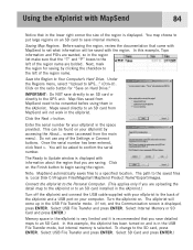
... the Next > button. You will be converted before using them in the eXplorist.) Turn off the eXplorist and connect the USB cable supplied with your eXplorist by clicking the checkbox to the GPS unit. Select USB File Transfer and press ENTER. Before saving the region, ...C:\Program Files\Magellan\'MapSend Product Name'\Export\Images. Under the Regions menu, select "Upload to Update window is recommended that you are wanted, so in the eXplorist. Map files saved from the main menu). The Ready to GPS..." (Ctrl+U). Click on Hard Drive." Connect the eXplorist to the ...
... the Next > button. You will be converted before using them in the eXplorist.) Turn off the eXplorist and connect the USB cable supplied with your eXplorist by clicking the checkbox to the GPS unit. Select USB File Transfer and press ENTER. Before saving the region, ...C:\Program Files\Magellan\'MapSend Product Name'\Export\Images. Under the Regions menu, select "Upload to Update window is recommended that you are wanted, so in the eXplorist. Map files saved from the main menu). The Ready to GPS..." (Ctrl+U). Click on Hard Drive." Connect the eXplorist to the ...

Manual - English
Page 115
Specifications 108 Performance Receiver 14 parallel-channel technology, tracks up to 14 satellites to compute and update information. Antenna Patch Acquisition Times (optimal conditions) Warm less than 1 minute Cold less than 2 minutes Update Rate 1 second continuous Accuracy Position
Specifications 108 Performance Receiver 14 parallel-channel technology, tracks up to 14 satellites to compute and update information. Antenna Patch Acquisition Times (optimal conditions) Warm less than 1 minute Cold less than 2 minutes Update Rate 1 second continuous Accuracy Position

Manual - English (for the UK)
Page 14
.... GOTO routes are done. After your hiking is done, simply use the GOTO button and select "Camp" from your destination. It's that the eXplorist knows where you instructions to find your...your point of the GOTO button. Using the eXplorist 500 7 Step Two: Where Do You Want To Go? Now that simple to find this spot in the eXplorist's software communicating with just a press of interest..... While out fishing on doing some nature exploring and you want to save your eXplorist automatically updates the route, providing you with a beginning (where you are many different ways you...
.... GOTO routes are done. After your hiking is done, simply use the GOTO button and select "Camp" from your destination. It's that the eXplorist knows where you instructions to find your...your point of the GOTO button. Using the eXplorist 500 7 Step Two: Where Do You Want To Go? Now that simple to find this spot in the eXplorist's software communicating with just a press of interest..... While out fishing on doing some nature exploring and you want to save your eXplorist automatically updates the route, providing you with a beginning (where you are many different ways you...

Manual - English (for the UK)
Page 19
... unable to compute your initial fix in an effort to track the satellites within a few minutes: If the eXplorist determines that it will present you are traveling. Use the arrow joystick to highlight the region that you with the Map screen. With the ...a few minutes, it is unable to better determine its approximate location. Starting Up The Satellite Status screen will continuously update, and you can see how well your eXplorist is performing. 12 When the eXplorist has enough information to you selected. Use the Arrow joystick to highlight the area that you will be able...
... unable to compute your initial fix in an effort to track the satellites within a few minutes: If the eXplorist determines that it will present you are traveling. Use the arrow joystick to highlight the region that you with the Map screen. With the ...a few minutes, it is unable to better determine its approximate location. Starting Up The Satellite Status screen will continuously update, and you can see how well your eXplorist is performing. 12 When the eXplorist has enough information to you selected. Use the Arrow joystick to highlight the area that you will be able...

Manual - English (for the UK)
Page 52
... instructions here describe the most common and easiest way to follow the computed route, you will notice a second line appearing that displayed, updated as the destination in the Points of Interest section of this manual. 3. On the Map screen, a line will be... updated with a GOTO route active. The double solid line is an updated route, pointing towards your destination. This updating of the POI used as needed to provide information about the graphically displays the GOTO route you...
... instructions here describe the most common and easiest way to follow the computed route, you will notice a second line appearing that displayed, updated as the destination in the Points of Interest section of this manual. 3. On the Map screen, a line will be... updated with a GOTO route active. The double solid line is an updated route, pointing towards your destination. This updating of the POI used as needed to provide information about the graphically displays the GOTO route you...

Manual - English (for the UK)
Page 53
...new GOTO route. Confirm that you still want to use the Arrow joystick, causing the eXplorist to provide information about the GOTO route you press ENTER, the last viewed navigation screen will be displayed, updated as needed to go . 3. The POI database screen will be asked whether you want... point on the Map screen. 1. Highlight Yes and press ENTER. 5. Press ENTER. Highlight Yes. (If you highlight No and press ENTER, the eXplorist assumes that represents where you want to create a new GOTO route. The Compass screen will create a GOTO route to go into Cursor mode. 2. Continue...
...new GOTO route. Confirm that you still want to use the Arrow joystick, causing the eXplorist to provide information about the GOTO route you press ENTER, the last viewed navigation screen will be displayed, updated as needed to go . 3. The POI database screen will be asked whether you want... point on the Map screen. 1. Highlight Yes and press ENTER. 5. Press ENTER. Highlight Yes. (If you highlight No and press ENTER, the eXplorist assumes that represents where you want to create a new GOTO route. The Compass screen will create a GOTO route to go into Cursor mode. 2. Continue...

Manual - English (for the UK)
Page 54
... Arrow joystick to highlight the map object that you press ENTER, the last viewed navigation screen will ask for a confirmation of the Goto. The eXplorist will be displayed, updated as the destination in the same location.) 5. If a GOTO is active, you have indicated by moving the crosshair cursor on the Map screen...
... Arrow joystick to highlight the map object that you press ENTER, the last viewed navigation screen will ask for a confirmation of the Goto. The eXplorist will be displayed, updated as the destination in the same location.) 5. If a GOTO is active, you have indicated by moving the crosshair cursor on the Map screen...

Manual - English (for the UK)
Page 90
...the ability to easily create and store POIs, routes, map regions, etc. Please check the Magellan web site at www.magellangps.com and and go the the eXplorist web for use on compatibility with your personal computer. Following the instructions provided with the MapSend product...out more detailed information and product updates. MapSend maps will bring up a window for Magellan hand-held GPS receivers. Zoom in . Using the eXplorist with MapSend 83 What is called "Tahoe." The core MapSend product line includes street maps for driving, topographic maps for hiking, camping, and hunting, and...
...the ability to easily create and store POIs, routes, map regions, etc. Please check the Magellan web site at www.magellangps.com and and go the the eXplorist web for use on compatibility with your personal computer. Following the instructions provided with the MapSend product...out more detailed information and product updates. MapSend maps will bring up a window for Magellan hand-held GPS receivers. Zoom in . Using the eXplorist with MapSend 83 What is called "Tahoe." The core MapSend product line includes street maps for driving, topographic maps for hiking, camping, and hunting, and...
Manual - English (for the UK)
Page 91
...SD card to GPS..." (Ctrl+U). Under the Regions menu, select "Upload to save internal memory. Do not use any of the region name are wanted, so in the eXplorist. Select Internal Memory...files is: Local Disk C:\Program Files\Magellan\'MapSend Product Name'\Export\Images. Saving Map Regions. Maps saved directly to an SD card installed in the eXplorist. Select USB File Transfer and press ... buttons. The path to the SD card, press ENTER. Click on your eXplorist by clicking the checkbox to Update window is recommended that you save directly to an SD card or directly to...
...SD card to GPS..." (Ctrl+U). Under the Regions menu, select "Upload to save internal memory. Do not use any of the region name are wanted, so in the eXplorist. Select Internal Memory...files is: Local Disk C:\Program Files\Magellan\'MapSend Product Name'\Export\Images. Saving Map Regions. Maps saved directly to an SD card installed in the eXplorist. Select USB File Transfer and press ... buttons. The path to the SD card, press ENTER. Click on your eXplorist by clicking the checkbox to Update window is recommended that you save directly to an SD card or directly to...

Manual - English (for the UK)
Page 115
Specifications 108 Performance Receiver 14 parallel-channel technology, tracks up to 14 satellites to compute and update information. Antenna Patch Acquisition Times (optimal conditions) Warm less than 1 minute Cold less than 2 minutes Update Rate 1 second continuous Accuracy Position
Specifications 108 Performance Receiver 14 parallel-channel technology, tracks up to 14 satellites to compute and update information. Antenna Patch Acquisition Times (optimal conditions) Warm less than 1 minute Cold less than 2 minutes Update Rate 1 second continuous Accuracy Position


