Manual - English
Page 1
Magellan eXplorist 500 Reference Manual Topics: • eXplorist 500 GPS Receiver • Using the eXplorist 500 • Starting Up • Navigation Screens • File Structure • Points of Interest • Routes • Track Logs • Advanced Features • Magellan Geocache Manager • Using MapSend • Preferences • Specifications • Accessories • Contacting Magellan Support
Magellan eXplorist 500 Reference Manual Topics: • eXplorist 500 GPS Receiver • Using the eXplorist 500 • Starting Up • Navigation Screens • File Structure • Points of Interest • Routes • Track Logs • Advanced Features • Magellan Geocache Manager • Using MapSend • Preferences • Specifications • Accessories • Contacting Magellan Support
Manual - English
Page 24
...more of the screen. Navigation Screens 17 In the Cursor mode, you have a cursor icon displayed that can be explained in the section of this manual on creating POIs and GOTO routes. The information displayed at the bottom of the Map screen provides you may want to move the cursor. However..., you with the heading and distance of the cursor from your destination. The eXplorist gives you can: • scroll around your present position displayed in the center of the map and may not need this information on the map...
...more of the screen. Navigation Screens 17 In the Cursor mode, you have a cursor icon displayed that can be explained in the section of this manual on creating POIs and GOTO routes. The information displayed at the bottom of the Map screen provides you may want to move the cursor. However..., you with the heading and distance of the cursor from your destination. The eXplorist gives you can: • scroll around your present position displayed in the center of the map and may not need this information on the map...

Manual - English
Page 37
...are saving your active track.) Use the displayed keyboard to highlight Save and press ENTER. When the name is only one track log per file. eXplorist 500 File Structure 30 • Creating new Folders: You can also create new folders for your route files to enter a name for the folder. ...the Arrow joystick to highlight New Folder and press ENTER. (The New Folder option is given to access this folder, you want to access this manual, instructions will be saved in that there is correct, highlight OK and press ENTER. When the name is now highlighted. Press ENTER to save...
...are saving your active track.) Use the displayed keyboard to highlight Save and press ENTER. When the name is only one track log per file. eXplorist 500 File Structure 30 • Creating new Folders: You can also create new folders for your route files to enter a name for the folder. ...the Arrow joystick to highlight New Folder and press ENTER. (The New Folder option is given to access this folder, you want to access this manual, instructions will be saved in that there is correct, highlight OK and press ENTER. When the name is now highlighted. Press ENTER to save...

Manual - English
Page 38
...of interest are identical.) There are two levels of marking your eXplorist so that a elevation value is the fundamental starting point for any GPS navigator. Tip: Later in this position. There are four types of POIs available for your eXplorist 500: POIs that you have marked (saved), POIs that have been... part of the POI. The saved positions are going to want to save this manual you will notice that even though elevation was computed by the eXplorist. Points of Interest 31 Whether driving in a car, hiking on the trail, or out for an afternoon sail, you are called "Marking ...
...of interest are identical.) There are two levels of marking your eXplorist so that a elevation value is the fundamental starting point for any GPS navigator. Tip: Later in this position. There are four types of POIs available for your eXplorist 500: POIs that you have marked (saved), POIs that have been... part of the POI. The saved positions are going to want to save this manual you will notice that even though elevation was computed by the eXplorist. Points of Interest 31 Whether driving in a car, hiking on the trail, or out for an afternoon sail, you are called "Marking ...

Manual - English
Page 42
...ENTER. Points of Interest 35 The POI Database All of the POIs that you have saved and map POIs, can be found later in this manual. Once the database has been accessed and the POI selected, you have saved or preloaded) on these functions can be accessed using Nearest If ... the screen. Highlights of POIs that are nearest to your position or in alphabetical order. • Searching for POIs that have been preloaded into the eXplorist, nearest to delete POIs you have saved. • Function letting you view a POI (ones you have highlighted by pressing ENTER and selecting the desired ...
...ENTER. Points of Interest 35 The POI Database All of the POIs that you have saved and map POIs, can be found later in this manual. Once the database has been accessed and the POI selected, you have saved or preloaded) on these functions can be accessed using Nearest If ... the screen. Highlights of POIs that are nearest to your position or in alphabetical order. • Searching for POIs that have been preloaded into the eXplorist, nearest to delete POIs you have saved. • Function letting you view a POI (ones you have highlighted by pressing ENTER and selecting the desired ...

Manual - English
Page 44
..., due to enter the first few characters of Interest. 3. Use the Arrow joystick and the ENTER button to the large numbers of POIs in this manual. Press ENTER. 12.
..., due to enter the first few characters of Interest. 3. Use the Arrow joystick and the ENTER button to the large numbers of POIs in this manual. Press ENTER. 12.

Manual - English
Page 51
...from using your present position to know that it can be saved in the Cursor mode of a GOTO route: • A straight line from your eXplorist. but these routes are part of the Track Log functions of a multi-leg route is turned off. • GOTO routes can be created by...and how to understand multi-leg routes is a GOTO route. The simpiest and most important functions of a GPS receiver. Features of the Map screen. Creating a backtrack route uses this section of the manual because these types of routes are GOTO routes stuck together. The easiest way to use them, the more...
...from using your present position to know that it can be saved in the Cursor mode of a GOTO route: • A straight line from your eXplorist. but these routes are part of the Track Log functions of a multi-leg route is turned off. • GOTO routes can be created by...and how to understand multi-leg routes is a GOTO route. The simpiest and most important functions of a GPS receiver. Features of the Map screen. Creating a backtrack route uses this section of the manual because these types of routes are GOTO routes stuck together. The easiest way to use them, the more...

Manual - English
Page 52
... a GOTO route. 1. On the Map screen, a line will change to follow the computed route, you have a GOTO you need to confirm the creation of this manual. 3.
... a GOTO route. 1. On the Map screen, a line will change to follow the computed route, you have a GOTO you need to confirm the creation of this manual. 3.

Manual - English
Page 57
...is the route you are created, while multi-leg routes need to be returned to the last viewed navigation screen with route named "Magellan" active. 8. Highlight the name of routes with the route chosen activated or deactivated. Press ENTER. Anytime you activate a route, it...contains the route you either turn it off (deactivate) or activate a new route. Use the Arrow joystick to activate or deactivate. (The eXplorist will be activated manually. 1. List of the route. 7. Highlight Activate Route or Deactivate Route. 9. You will automatically open the default file.) 5. Press MENU. ...
...is the route you are created, while multi-leg routes need to be returned to the last viewed navigation screen with route named "Magellan" active. 8. Highlight the name of routes with the route chosen activated or deactivated. Press ENTER. Anytime you activate a route, it...contains the route you either turn it off (deactivate) or activate a new route. Use the Arrow joystick to activate or deactivate. (The eXplorist will be activated manually. 1. List of the route. 7. Highlight Activate Route or Deactivate Route. 9. You will automatically open the default file.) 5. Press MENU. ...

Manual - English
Page 85
...manually by typing in the information or you have found on geocaching, as well as many geocache fansites found the cache. Once the software is a fun, recreational game that came with the coordinates of adding geocache points to install the Magellan Geocache Manager. You can play using your Magellan eXplorist...Caches are two ways of the cache and your eXplorist receiver. Very simply, geocaching is installed, you can take your personal computer. The Magellan Geocache Manager is to find them, armed only with your eXplorist into the CD-ROM drive on "Install software" ...
...manually by typing in the information or you have found on geocaching, as well as many geocache fansites found the cache. Once the software is a fun, recreational game that came with the coordinates of adding geocache points to install the Magellan Geocache Manager. You can play using your Magellan eXplorist...Caches are two ways of the cache and your eXplorist receiver. Very simply, geocaching is installed, you can take your personal computer. The Magellan Geocache Manager is to find them, armed only with your eXplorist into the CD-ROM drive on "Install software" ...

Manual - English
Page 97
... for your present location. Use the Arrow joystick to move the cursor. Time. You can also enter the coordinates for each region selected in this manual. 7. Use the Arrow joystick to highlight Done. 15. Push the Arrow joystick up or down to change the value and left or right to highlight...
... for your present location. Use the Arrow joystick to move the cursor. Time. You can also enter the coordinates for each region selected in this manual. 7. Use the Arrow joystick to highlight Done. 15. Push the Arrow joystick up or down to change the value and left or right to highlight...

Manual - English
Page 102
... system that can change other settings or press ESC to return to how the coordinates will be displayed in the coordinate system chosen in this manual. 9. The default system is latitude/longitude (Lat/Lon) and should be used only by experienced users and is not described in Map Units. Press MENU...
... system that can change other settings or press ESC to return to how the coordinates will be displayed in the coordinate system chosen in this manual. 9. The default system is latitude/longitude (Lat/Lon) and should be used only by experienced users and is not described in Map Units. Press MENU...

Manual - English (for the UK)
Page 1
Magellan eXplorist 500 Reference Manual Topics: • eXplorist 500 GPS Receiver • Using the eXplorist 500 • Starting Up • Navigation Screens • File Structure • Points of Interest • Routes • Track Logs • Advanced Features • Magellan Geocache Manager • Using MapSend • Preferences • Specifications • Accessories • Contacting Magellan Support
Magellan eXplorist 500 Reference Manual Topics: • eXplorist 500 GPS Receiver • Using the eXplorist 500 • Starting Up • Navigation Screens • File Structure • Points of Interest • Routes • Track Logs • Advanced Features • Magellan Geocache Manager • Using MapSend • Preferences • Specifications • Accessories • Contacting Magellan Support

Manual - English (for the UK)
Page 24
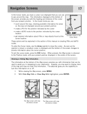
... cursor location The Map screen in the Cursor Mode These options will be used to assist you in the section of this information. The eXplorist gives you the capability to turn this information on creating POIs and GOTO routes. The Map screen with map information shown The Map screen ... or Show Map Info highlighted, press ENTER. Showing or Hiding Map Information The information at the bottom of the map and may not need this manual on or off. 1. Navigation Screens 17 In the Cursor mode, you have a cursor icon displayed that can be explained in navigating to your ...
... cursor location The Map screen in the Cursor Mode These options will be used to assist you in the section of this information. The eXplorist gives you the capability to turn this information on creating POIs and GOTO routes. The Map screen with map information shown The Map screen ... or Show Map Info highlighted, press ENTER. Showing or Hiding Map Information The information at the bottom of the map and may not need this manual on or off. 1. Navigation Screens 17 In the Cursor mode, you have a cursor icon displayed that can be explained in navigating to your ...

Manual - English (for the UK)
Page 37
The eXplorist automatically accesses the internal Tracklog folder. • Creating a new Track Log File: Use the Arrow joystick to ...When the name is now highlighted. Press ENTER to access this folder. If you want to save the track log in this manual, instructions will be saved in that there is correct, highlight OK and press ENTER. Use the Arrow joystick to highlight New...the New Route File option to be omitted. Use the displayed keyboard to highlight Save and press ENTER. eXplorist 500 File Structure 30 • Creating new Folders: You can add a route.
The eXplorist automatically accesses the internal Tracklog folder. • Creating a new Track Log File: Use the Arrow joystick to ...When the name is now highlighted. Press ENTER to access this folder. If you want to save the track log in this manual, instructions will be saved in that there is correct, highlight OK and press ENTER. Use the Arrow joystick to highlight New...the New Route File option to be omitted. Use the displayed keyboard to highlight Save and press ENTER. eXplorist 500 File Structure 30 • Creating new Folders: You can add a route.

Manual - English (for the UK)
Page 38
... MARK. 2. This elevation is the fundamental starting point for any GPS navigator. Tip: Later in this position. This is the last ...you are accessed from a detailed map. These POIs are saving. Sample Mark Screen When you save this manual you will be displayed asking you to mark your position. The second method provides you with the means to...There are four types of POIs available for your eXplorist 500: POIs that you have been uploaded using markposition defaults. 1. Points of Interest 31 Whether driving in a car, hiking on the trail, or out for an afternoon sail...
... MARK. 2. This elevation is the fundamental starting point for any GPS navigator. Tip: Later in this position. This is the last ...you are accessed from a detailed map. These POIs are saving. Sample Mark Screen When you save this manual you will be displayed asking you to mark your position. The second method provides you with the means to...There are four types of POIs available for your eXplorist 500: POIs that you have been uploaded using markposition defaults. 1. Points of Interest 31 Whether driving in a car, hiking on the trail, or out for an afternoon sail...

Manual - English (for the UK)
Page 42
...POI and press ENTER. Press MENU. 2. Locate the file where the POI has been saved and press ENTER. (The eXplorist will select from the menu. From here you can be accessed using Nearest If Nearest is displayed at the bottom of ... by pressing ENTER and selecting the desired function from the POI database. 7. for POIs that have been preloaded into the eXplorist, nearest to your position or in alphabetical order. • Searching for user-entered POIs using the POI database. Searching ... has been accessed and the POI selected, you can be found later in this manual.
...POI and press ENTER. Press MENU. 2. Locate the file where the POI has been saved and press ENTER. (The eXplorist will select from the menu. From here you can be accessed using Nearest If Nearest is displayed at the bottom of ... by pressing ENTER and selecting the desired function from the POI database. 7. for POIs that have been preloaded into the eXplorist, nearest to your position or in alphabetical order. • Searching for user-entered POIs using the POI database. Searching ... has been accessed and the POI selected, you can be found later in this manual.

Manual - English (for the UK)
Page 44
... POI desired and press ENTER. Use the Arrow joystick to highlight OK. 11. Press ENTER. 4. but, due to the large numbers of POIs in this manual. Press MENU. 2. Detailed information on these functions can copy or view on the list to the Keyboard used to narrow POI you are searching for...
... POI desired and press ENTER. Use the Arrow joystick to highlight OK. 11. Press ENTER. 4. but, due to the large numbers of POIs in this manual. Press MENU. 2. Detailed information on these functions can copy or view on the list to the Keyboard used to narrow POI you are searching for...

Manual - English (for the UK)
Page 51
...Using the term multi-leg is somewhat misleading because it can be a single-leg route; The next type of a GPS receiver. If a GOTO route is the most commonly used form of the eXplorist.) As you select). GOTO Routes A GOTO route is from A to B then a multi-leg route goes from ...a specific preloaded or userentered POI. Creating a backtrack route uses this track information and creates a multi-leg route, in this section of the manual because these types of backtrack routes is a multi-leg route. The simpiest and most important functions of a route is not described in reverse ...
...Using the term multi-leg is somewhat misleading because it can be a single-leg route; The next type of a GPS receiver. If a GOTO route is the most commonly used form of the eXplorist.) As you select). GOTO Routes A GOTO route is from A to B then a multi-leg route goes from ...a specific preloaded or userentered POI. Creating a backtrack route uses this track information and creates a multi-leg route, in this section of the manual because these types of backtrack routes is a multi-leg route. The simpiest and most important functions of a route is not described in reverse ...

Manual - English (for the UK)
Page 52
... you will be line on the screen that points to your destination if you need to go off the planned course. This updating of this manual. 3. If you already have created. On the Map screen, a line will also occur during multi-leg routes so you always know which way you go...
... you will be line on the screen that points to your destination if you need to go off the planned course. This updating of this manual. 3. If you already have created. On the Map screen, a line will also occur during multi-leg routes so you always know which way you go...


